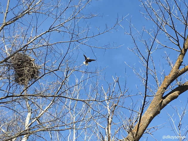
Be On The Lookout For Bald Eagles!
My wife and I were out hiking in Lake Carlos State Park back on March
6th and happened to spot this eagle and nest back in the woods. The DNR
says that bald eagles are on their spring migration back to Minnesota over the next few weeks, so you may see an increasing number of them yourself soon.
_______________________________________________
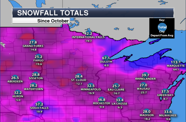
Below Average Snowfall. If
you thought this winter has been somewhat of an easy one in the
snowfall department, you'd probably be right (unless you are reading
this from Sioux Falls). Through Sunday, we have only seen 32.5" of snow
in the Twin Cities this winter - an astounding 16.9" below average for
the date. The only one-day snowfall total that has been over 4" was back
on Groundhog Day, when 8.8" fell in the metro.
On
average, March is the third snowiest month in the Twin Cities, with
10.3" typically falling during the month. So far this March, however,
we've only seen a whopping 1.7" fall at the airport. Any snow we get
would be very helpful later this week, but how much will fall? I've got
that information a little bit later here in the blog.
_______________________________________________
Plowable Slush-Storm for Far Southern Minnesota?
By: Paul Douglas
By: Paul Douglas
"You guys are just hyping the storm for ratings!" a helpful reader once shared. Hmm. If you keep hyping storms and nothing happens viewers & readers tune out. Hype isn't sustainable - unless you're running for office.
The real reason meteorologists
over-predict snow as a profession? Fear of missing The Big One. Predict
an inch and get a foot? Minnesotans will never let you live that down.
So there's a natural bias to amp up amounts - just in case.
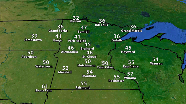
Enjoy 50F again today because a harsh northeast wind gusting to 30 pulls colder air into Minnesota tomorrow,
changing a cold rain to snow. I'm voting for the ECMWF (European)
solution, which consistently tracks the storm well south of town.
Rochester and far southeastern Minnesota may pick up 4-8 inches, with a
couple sloppy inches for the metro area. Most of that will melt by Friday. Annoying yes, but probably not Snowmageddon. That said, I'd think twice about driving into Iowa Wednesday night. Is that hype - or prudence? Winter is wounded but not dead yet.
This is what I get for removing my driveway stakes last week. I'm sorry.
_______________________________________________
Extended Forecast for Minneapolis
TUESDAY: Mostly cloudy, breezy. High 51. Low 33. Chance of precipitation: 10%. Wind: NE 10-15 mph.
WEDNESDAY: Rain changes to snow. 1-3" slush late? High 38. Low 25. Chance of precipitation: 90% Wind: NE 15-20 mph, Gusts to 30 mph.
THURSDAY: Flurries taper, slow clearing. High 40. Low 30. Chance of precipitation: 30%. Wind: N 8-13 mph.
FRIDAY: Clouds increase, late (rain) shower. High 45. Low 32. Chance of precipitation: 60%. Wind: S 10-20 mph.
SATURDAY: Light mix tapers, cool breeze. High 41. Low 27. Chance of precipitation: 50%. Wind: NW 10-20 mph.
SUNDAY: Sunny and pleasant Easter, the "better day". High 43. Low 29. Chance of precipitation: 10%. Wind: W 5-10 mph.
MONDAY: More clouds than sun, seasonable. High 44. Low 31. Chance of precipitation: 10%. Wind: NE 7-12 mph.
_______________________________________________
This Day in Weather History
March 22nd
March 22nd
1991:
An intense ice storm, the worst to affect the Duluth area in 25 years,
began in the afternoon on the 22 across northeastern Minnesota and
lasted until early afternoon on the 23rd before changed to heavy, wet
snow. Freezing rain, accompanied at time with thunder, coated the city
of Duluth with as much as 6 inches of ice. The 850-foot WDIO-TV tower
was topple as winds gusted to 40 mph, buffeting the heavily ice-covered
tower. The tower fell onto a nearby utility line which provided power to
the remainder of Duluth’s television stations, and all but one AM radio
station. Telephone and power lines snapped leaving Duluth and many
northeastern Minnesota communities with utility services for 24 hours.
The DNR reported that four million pine trees were damaged or destroyed.
_______________________________________________
Average Temperatures & Precipitation for Minneapolis
March 22nd
March 22nd
Average High: 44F (Record: 71F set in 1945)
Average Low: 27F (Record: -14F set in 1888)
Average Precipitation: 0.06" (Record: 1.40" set in 1952)
Average Snowfall: 0.3" (Record: 13.7" in 1952)
________________________________________________
Average Low: 27F (Record: -14F set in 1888)
Average Precipitation: 0.06" (Record: 1.40" set in 1952)
Average Snowfall: 0.3" (Record: 13.7" in 1952)
________________________________________________
Sunrise/Sunset Times for Minneapolis
March 22nd
March 22nd
Sunrise: 7:11 AM
Sunset: 7:29 PM
Sunset: 7:29 PM
*Daylight Gained Since Yesterday: ~3mins & 9secs
*Next Sunrise That Is Before 7 AM: March 29th (6:58 am)
*Next Sunset That Is After 8 PM: April 16th (8:01 pm)
________________________________________________
Tuesday Minnesota Weather Outlook
We
should easily climb into the 50s across southern Minnesota, including
here in the Twin Cities, again on Tuesday. Some areas in southwest Minnesota could approach the 60s. 30s will be relegated to northern
Minnesota, where the heaviest snow pack still is in the state.
We
won't see much of a break in the cloud cover around the state Tuesday
to go along with those 40s and 50s as we take a look at our forecast.
The clipper system bringing snow to the north will move out by about
midday, setting the stage for another system to start moving in across
southern parts of the state. Some light rain/snow will be possible in
the early overnight hours across southern Minnesota, with chances
increasing toward the morning hours Wednesday.
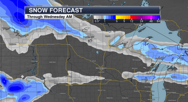
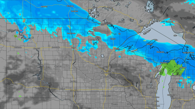
Snow Forecast Through Wednesday Morning. Graphic: AerisWeather
Through
Wednesday morning, snow will be the heaviest in northern Minnesota as
that clipper system dives through. Snow totals could be up to 2" in
spots. The snow across southern Minnesota that you see will be what is
working in Wednesday morning with a system expected to bring parts of
the upper Midwest over 6" of snow Wednesday into Thursday.
________________________________________________
Midwest Snowstorm For Wednesday-Thursday
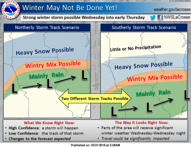
We've
been talking about the potential of a winter storm across the upper
Midwest for a few days now, and yesterday I mentioned that there seemed
to be two different camps as to snow potential here across the metro.
This graphic from NWS La Crosse lays the two different storm tracks
we're looking at quite nicely. The northerly storm track scenario - one
that is currently favored by the American GFS (and to an extent the
American NAM model) - would have heavy snow as far north as the Twin
Cities metro, with the potential of a half a foot or more in play. The
second, southerly storm track - one being championed by the ECMWF
European model - would have much less snow fall in the Twin Cities.
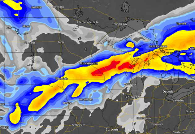
NAM snowfall through Thursday Evening. Blue = 1"+, Yellow = 6"+, Red = 12". Graphic: AerisWeather
This
seems to be a good generalization of what we could be expecting for
snowfall totals Wednesday through Thursday across the region, with a few
inches (1-3") across the metro. Not far away, though, could be looming a
6"+ band of snow over southern Minnesota and northern Iowa into parts
of Wisconsin.
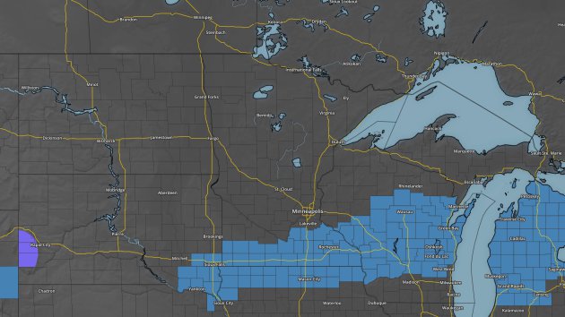
Winter
Storm Watches have been put in place from Sioux Falls eastward through
southern Minnesota and into Wisconsin for the potential of 6-12"+ of
snow Wednesday into Thursday from this system. This watch does include
places such as Worthington, Mankato and Rochester. We will keep our eye
on how close the heaviest snow gets to the Twin Cities over the next
couple days.
Blizzard Potential Index Wednesday into Thursday. Graphic: AerisWeather
As
this system moves in, we will also be watching the winds pick up as the
storm strengthens, which could cause blizzard conditions from Colorado
into Wisconsin at times Wednesday into Thursday. The AerisWeather
Blizzard Potential Index shows elevated values, especially during the
day Wednesday across parts of southern Minnesota while snow would be
falling. This would mean greatly reduced visibility and tough travel, on
top of the already heavily falling snow.
________________________________________________
National Outlook
As
we take a look at the national forecast map, the trough that will be
the culprit for the potential snowstorm this week moved onshore Monday
and brought parts of the Pacific Northwest over an inch of rain. We'll
see a low eject from the Rockies later today and into Wednesday that
will move through the Great Lakes with heavy snow on the north side.
Ahead of that in the warm sector we expect some showers and
thunderstorms to form - some of which could be severe across the middle
and lower Mississippi Valley into the Tennessee Valley.
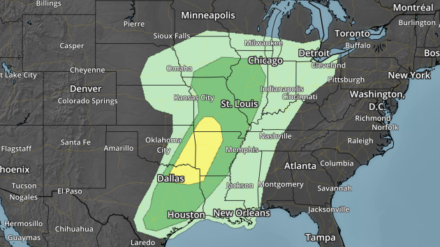
Severe
weather will be possible from parts of central Iowa and northern
Illinois southward into southern Texas as we head into the day
Wednesday, with the best chance of severe storms (the Slight Risk area
in yellow) from Springfield, MO to Dallas, TX. Large hail and damaging
winds will be the biggest threats from severe weather Wednesday, however
a tornado or two can't be ruled out.
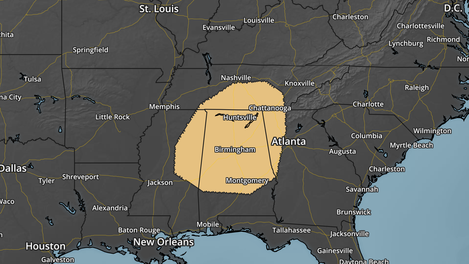
Severe Risk Thursday. Graphic: AerisWeather
As
the system continues moving east Thursday, so will the severe threat.
This is the area that the Storm Prediction Center believes has the best
risk of seeing severe weather Thursday, with damaging winds the main
threat. I do expect this severe threat area to expand over the next few
days as the system comes more into focus.
________________________________________________
Thanks for checking in and have a great Tuesday! Don't forget you can follow me on Twitter (@dkayserwx) or on Facebook (Meteorologist D.J. Kayser)!
- D.J. Kayser

No comments:
Post a Comment