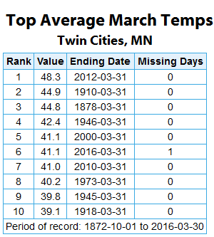
Top Ten Warmest Marches At MSP. Through Wednesday, the average March temperature in the Twin Cities was 41.1 degrees, which would be good enough to tie the fifth warmest March on record with Thursday left to go. That was on the back of three record highs and three record high minimums earlier this month. The final numbers for the month will roll in later Friday and I'll have a March recap in the Saturday morning blog.
______________________________
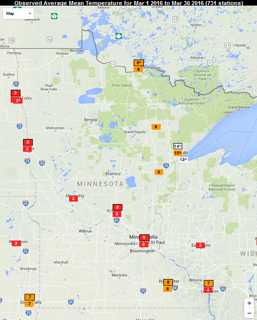
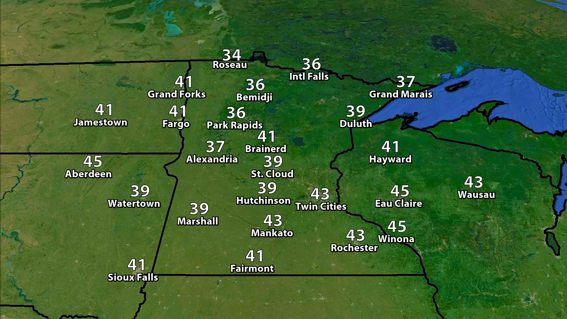
Warm March Across The State.
Using only data through the 30th, we can see most locations (with the
exception of Duluth) look to end the month within the top ten warmest.
It's been the third warmest first 30 days of March in St. Cloud, 8th
warmest in International Falls and Rochester, and 14th warmest in
Duluth.
______________________________
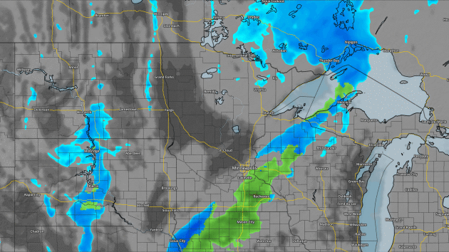
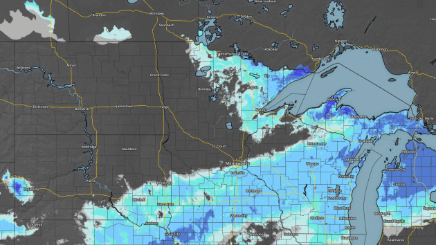 Loop of estimated snow depth across the state from Friday, March 25th to Thursday, March 31st. Graphic: AerisWeather Aeris Map Platform (AMP).
______________________________
Snow Cover Disappearing Across The State.
The warmth has been good for one thing - getting rid of the snow cover
across the state. This is a loop of estimated snow depth from last
Friday (the 25th) through Thursday, showing the only snow left across
the state in the Arrowhead.
______________________________
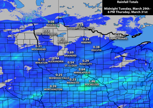
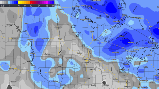
Rainfall Past Few Days. Between Midnight Tuesday and 6 PM on Thursday we picked up 0.64" of rain at the Twin Cities airport, with numerous totals between a quarter and three quarters of an inch across central and southern Minnesota. Some of the largest totals have been in southeastern Minnesota, where 1.59" fell in Winona and 1.46" in Rochester (again, totals from midnight Tuesday through 6 PM Thursday).
Duluth has now seen 3.94" of liquid this March, good enough for the fifth wettest March on record.
When I was young I'd compare dreams, aspirations and horsepower with my buddies. Now we compare minor injuries and medications. I guess it's part of the human condition to compare and contrast.
A year ago today it was 84F in the Twin Cities. But on this date in 1975 the metro woke up to 9F; it snowed nearly 5 inches on April 1, 2002. Spring at this latitude is...volatile.
A twist of cold air aloft may spark a quick coating of slush early; the sun now high enough in the southern sky to keep roads wet during the daylight hours. You'll need a heavy jacket into Saturday, but a fleeting surge of warmth boosts us into the 50s Sunday, before cooling off early next week.
Model guidance suggests that warm frontal passages will become more aggressive as we sail into mid-April; 50s and 60s the rule, not the exception.
El Nino is fading fast, but a persistent warm signal is expected to linger into the summer. NOAA data suggests a greater risk of sliding into a La Nina cool phase by autumn. That could, in turn, increase the threat of drought by late summer - something we'll have to watch.
______________________________
Rainfall Past Few Days. Between Midnight Tuesday and 6 PM on Thursday we picked up 0.64" of rain at the Twin Cities airport, with numerous totals between a quarter and three quarters of an inch across central and southern Minnesota. Some of the largest totals have been in southeastern Minnesota, where 1.59" fell in Winona and 1.46" in Rochester (again, totals from midnight Tuesday through 6 PM Thursday).
Duluth has now seen 3.94" of liquid this March, good enough for the fifth wettest March on record.
______________________________
No April Fools Joke: Slushy Coating Possible
By Paul Douglas
By Paul Douglas
When I was young I'd compare dreams, aspirations and horsepower with my buddies. Now we compare minor injuries and medications. I guess it's part of the human condition to compare and contrast.
A year ago today it was 84F in the Twin Cities. But on this date in 1975 the metro woke up to 9F; it snowed nearly 5 inches on April 1, 2002. Spring at this latitude is...volatile.
A twist of cold air aloft may spark a quick coating of slush early; the sun now high enough in the southern sky to keep roads wet during the daylight hours. You'll need a heavy jacket into Saturday, but a fleeting surge of warmth boosts us into the 50s Sunday, before cooling off early next week.
Model guidance suggests that warm frontal passages will become more aggressive as we sail into mid-April; 50s and 60s the rule, not the exception.
El Nino is fading fast, but a persistent warm signal is expected to linger into the summer. NOAA data suggests a greater risk of sliding into a La Nina cool phase by autumn. That could, in turn, increase the threat of drought by late summer - something we'll have to watch.
______________________________
Extended Forecast for Minneapolis
FRIDAY: Early coating, chilly. High 40. Low 28. Chance of Precipitation: 60%. Wind NW 15-25 mph.
SATURDAY: Blustery clipper, few flurries. High 38. Low 29. Chance of Precipitation: 50%. Wind NW 15-35 mph.
SUNDAY: Sunnier, milder. Instant spring. High 57. Low 30. Chance of Precipitation: 10%. Wind SW 10-20 mph.
MONDAY: Some sun - cooling off. High 43. Low 33. Chance of Precipitation: 10%. Wind N 10-15 mph.
TUESDAY: Clouds increase, few rain showers. High 46. Low 39. Chance of Precipitation: 50%. Wind SE 10-20 mph.
WEDNESDAY: Showers slowly taper. High 44. Low 33. Chance of Precipitation: 70%. Wind NW 10-20 mph.
THURSDAY: Gradual clearing, still chilly. High 42. Low 29. Chance of Precipitation: 10%. Wind NW 10-20 mph.
Sunset: 7:42 PM
*Length Of Day: 12 hours, 48 minutes and 46 seconds
*Daylight Gained Since Yesterday: ~3mins & 7secs
*Next Sunrise That Is Before 6:30 AM: April 14th (6:29 am)
*Next Sunset That Is After 8 PM: April 16th (8:01 pm)
Friday Minnesota Weather Outlook
SATURDAY: Blustery clipper, few flurries. High 38. Low 29. Chance of Precipitation: 50%. Wind NW 15-35 mph.
SUNDAY: Sunnier, milder. Instant spring. High 57. Low 30. Chance of Precipitation: 10%. Wind SW 10-20 mph.
MONDAY: Some sun - cooling off. High 43. Low 33. Chance of Precipitation: 10%. Wind N 10-15 mph.
TUESDAY: Clouds increase, few rain showers. High 46. Low 39. Chance of Precipitation: 50%. Wind SE 10-20 mph.
WEDNESDAY: Showers slowly taper. High 44. Low 33. Chance of Precipitation: 70%. Wind NW 10-20 mph.
THURSDAY: Gradual clearing, still chilly. High 42. Low 29. Chance of Precipitation: 10%. Wind NW 10-20 mph.
______________________________
This Day in Weather History
April 1st
2015: A record high of 84 degrees is set at Minneapolis.April 1st
______________________________
Average Temperatures & Precipitation for Minneapolis
April 1st
April 1st
Average High: 50F (Record: 84F set in 2015)
Average Low: 31F (Record: 9F set in 1975)
Average Precipitation: 0.07" (Record: 0.54" set in 1967)
Average Snowfall: 0.1" (Record: 4.6" in 2002)
______________________________
Average Low: 31F (Record: 9F set in 1975)
Average Precipitation: 0.07" (Record: 0.54" set in 1967)
Average Snowfall: 0.1" (Record: 4.6" in 2002)
______________________________
Sunrise/Sunset Times for Minneapolis
April 1st
Sunrise: 6:53 AMApril 1st
Sunset: 7:42 PM
*Length Of Day: 12 hours, 48 minutes and 46 seconds
*Daylight Gained Since Yesterday: ~3mins & 7secs
*Next Sunrise That Is Before 6:30 AM: April 14th (6:29 am)
*Next Sunset That Is After 8 PM: April 16th (8:01 pm)
______________________________
April
will start off on a cool note across the region, with highs only
reaching the low to mid 40s in the Twin Cities - 5-10 degrees below
average for this time of year. Highs statewide will be in the 30s and
40s.
Another
system will be departing early Friday morning after bringing some light
rain and snow to the region Thursday night. The next system will be a
clipper, bringing the best chance of any accumulating snow to northern
Minnesota. However, we do stand to see some light rain and snow across
central and southern Minnesota Friday night as it moves through.
Snow forecast through Saturday evening.
To
be honest, I'm ready to put the snow maps away for the year. However,
with that clipper moving through northern Minnesota Friday Night into
early Saturday, a few inches of snow is possible.
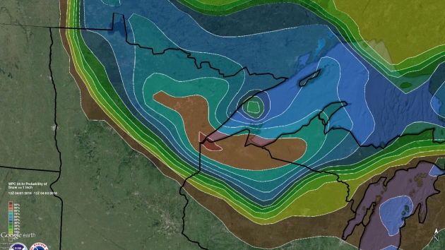
The
Weather Prediction Center says that the chance of seeing at least one
inch of snow Friday and Friday Night will be highest in the Duluth area,
with chances decreasing as you head up the North Shore.
______________________________
National Outlook
Looking
nationwide, we're watching a cold front sliding south and east over the
next couple days, bringing with it a severe weather threat across
portions of the Southeast into Mid-Atlantic. The other story we'll be
watching is a couple clipper systems that will bring parts of the the
Great Lakes region some snow.
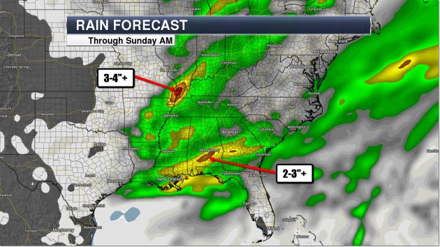
As
the front moves east, heavy rain will be likely across portions of the
Southeast over the next few days. Some areas could pick up 2-4"+ through
Sunday morning, leading to the potential of some flash flooding.
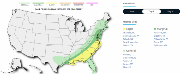
Severe threat Friday.
Severe
weather will also be possible as the front moves east on Friday. The
best chance of severe weather will be across portions of the Southeast
and Mid-Atlantic, including Charlotte, NC and New Orleans, LA. However, a
marginal threat of severe weather extends as far north as New York and
Washington D.C. Damaging winds, large hail and tornadoes are all
possible.
______________________________
Thanks for checking in and have a great Friday! Don't forget you can follow me on Twitter (@dkayserwx) or on Facebook (Meteorologist D.J. Kayser)!
- D.J. Kayser

No comments:
Post a Comment