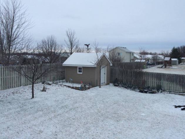
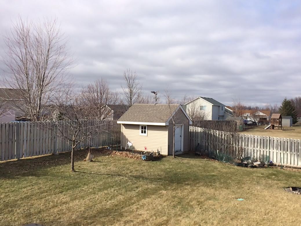
A coating of snow Saturday morning was sure pretty to look at, but caused some major issues on area roads... The good news is that it melted rather quickly in the morning as temperatures warmed into the mid 30s. The pictures below were taken AM Saturday and PM Sunday; two different landscapes.
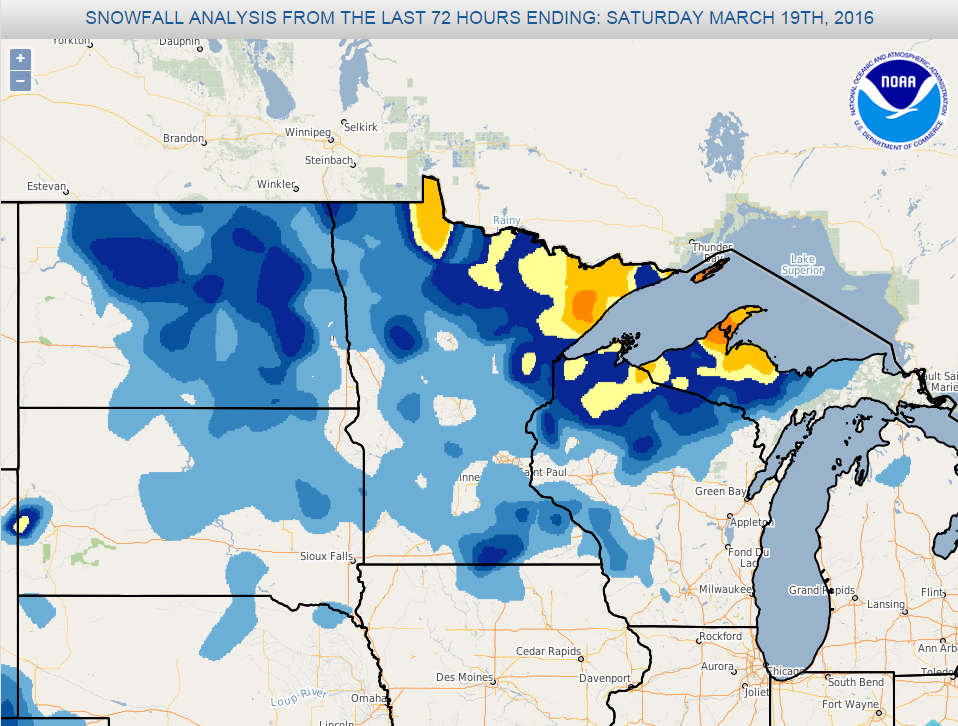
Snowfall Analysis From Last Week
A
large area of low pressure sat over the Western Great Lakes last week
and brought some heavy snow (6" to 12"+) across parts of
northeastern Minnesota, northern Wisconsin and the U.P. of Michigan. As
the storm system began to deteriorate, lingering moisture continue to
wrap through the region with lingering light snowfall, which lasted
through the early weekend.
Lake Superior Surfers??
Hey, this is neat... the same storm system that brought heavy snow to parts of the Western Great Lakes also brought strong winds and large waves to Lake Superior. In fact, the waves were so big that they drew the attention of fresh water surfers!! A good friend of mine, Adam Jagunich took some great video earlier this week.
See the video HERE:

_________________________________
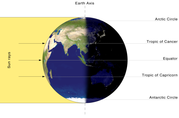
2016 is the Earliest Spring Since 1896!!!
Did you know that this years vernal equinox (spring) is the earlier since 1896? Here's why:
"2016
has the earliest spring since 1896. The March equinox can come on March
19, 20 or 21. And 2016 has the earliest March equinox since the year
1896. Is it a coincidence that 2012 also had the earliest spring since
1896? No. Recall that both 2012 and 2016 are leap years. But 2016’s
spring comes even earlier than the spring of 2012. In
a nutshell, this earliest spring is happening because the tropical
year, as measured between successive March equinoxes, doesn't’t have an
even number of days (365.242 days). Our calendar, on the other hand, has
an even 365 days in a common year and 366 days in a leap year."
Mark Seeley's Weather Talk:
Ever Friday, University of Minnesota climatologist Mark Seeley, puts together a nice piece regarding local weather... here's an excerpt from this weeks Weather Talk:
Last weekend produced some record-setting March high temperatures. Some of those reported over March 12 and 13 included:
74°F at Madison
73°F at Milan, Marshall, and Pipestone
72°F at Wheaton and Browns Valley
71°F at Montevideo
70°F at MSP, Willmar, Mora, Redwood Falls, and Lake Wilson
69°F at Winnebago and New Ulm
68°F at Windom, Lakefield, St Cloud, and Morrisw
67°F at Ada, Kimball, and Moose Lake
66°F at Moorhead and Isle
65°F at Austin and Preston
60°F at Duluth and International Falls
So far this month over 60 new daily warm maximum temperature records have been reported across Minnesota, and over 60 new warm daily minimum temperature records have been reported as well. Communities around the state are reporting average March temperatures so far that run from 11 to 15 degrees F above normal. This has provoked very early ice-out dates for many of Minnesota’s lakes, including Lake Minnetonka (Hennepin and Carver Counties) which saw loss of ice on March 17th, the earliest date since March 11, 1878. Other lakes that recorded earliest ice-out dates in history included: White Bear (Washington County) on March 16th; Cedar Lake (Scott County) on March 13th; and French Lake (Rice County) on March 15th.
Read more from this week's Weather Talk from UMN.edu HERE:

By Paul Douglas
This is about as chilly as it's going to get anytime soon. And no, ice will not be re-forming on area lakes. Lake Minnetonka just experienced the earliest ice-out since March 11, 1878. According to Dr. Mark Seeley White Bear and Cedar lake saw the earliest ice-outs on record. Over 60 new daily maximum temperatures and 60 warm daily minimum temperature records have been set so far in March. This month is running over 12F warmer than average, in spite of the recent cool-down. For the record today is "average", where we should be on March 19. We've just lost track of reality.
Keep a jacket handy, but go ahead and stash the parkas and boots into cold storage. 40s return next week; another puff or two of Canadian air before a Pacific flow boosts temperatures into the 50s and 60s in April. One more big and sloppy, slushy encounter? I don't see it - although a light mix is possible by Thursday. Hey, I removed my driveway stakes. What can possibly go wrong?
Disclaimer: when weather is too quiet for too long I start to get nervous. Because at some point the other shoe always drops.
___________________________________
Extended Forecast
SUNDAY:Partly sunny and pleasant. Winds: NW 7-12. High: 43
SUNDAY NIGHT: Mostly cloudy, nothing rough. Winds: NW 5-10. Low: 29
MONDAY: Sunny intervals, milder breeze. Winds: SE 10-20. High: 48
TUESDAY: More clouds than sun, mild. Winds: E 5-10. Wake-up: 33. High: 50
WEDNESDAY: Overcast, chance of rain. Winds: NE 10-20. Wake-up: 39. High: 43.
THURSDAY: Sloppy mix, slowly tapers. Winds: N 10-15. Wake-up: 33. High: 38.FRIDAY: Sunny start. Showery PM mix. Winds: S 8-13. Wake-up; 38. High: 40.
SATURDAY: Clearing. Cooler breeze kicks in. Winds: NW 10-15. Wake-up: 30. High: 37.
______________________________________
This Day in Weather History
March 20th
1991: An early season tornado hits Faribault county from Bricelyn to Wells.
______________________________________
Average High/Low for Minneapolis
March 20th
Average High: 43F (Record: 57F set in 2012)
Average Low: 26F (Record: -9F set in 1965)
_______________________________________
Sunrise/Sunset Times for Minneapolis
March 20th
Sunrise: 7:15am
Sunset: 7:26pm
*Daylight Gained Since Yesterday: ~3mins & 9secs
*Daylight Gained Since Winter Solstice (Dec. 21st): ~3hour & 25mins
_______________________________________
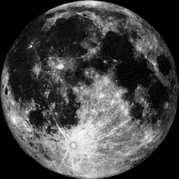
Moon Phase for March 20th at Midnight
2.2 Days Until Full (Worm) Moon
________________________________________
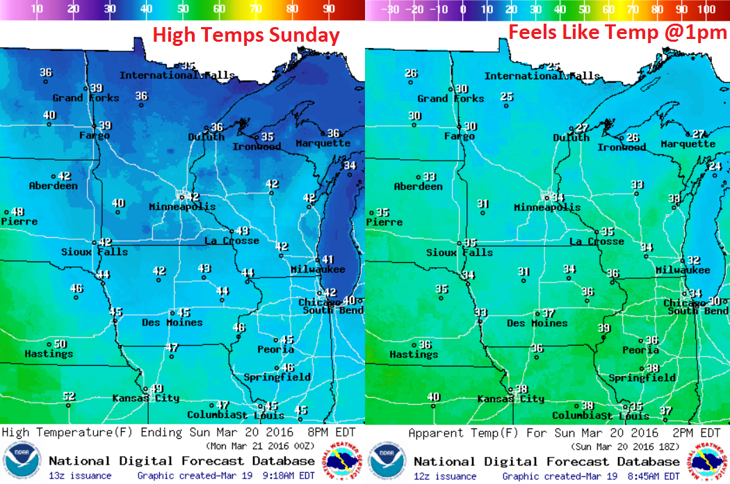
Sunday Weather Outlook
High temperatures on Sunday will once again be near average for mid/late March, but winds will still make it feel a little cooler midday.
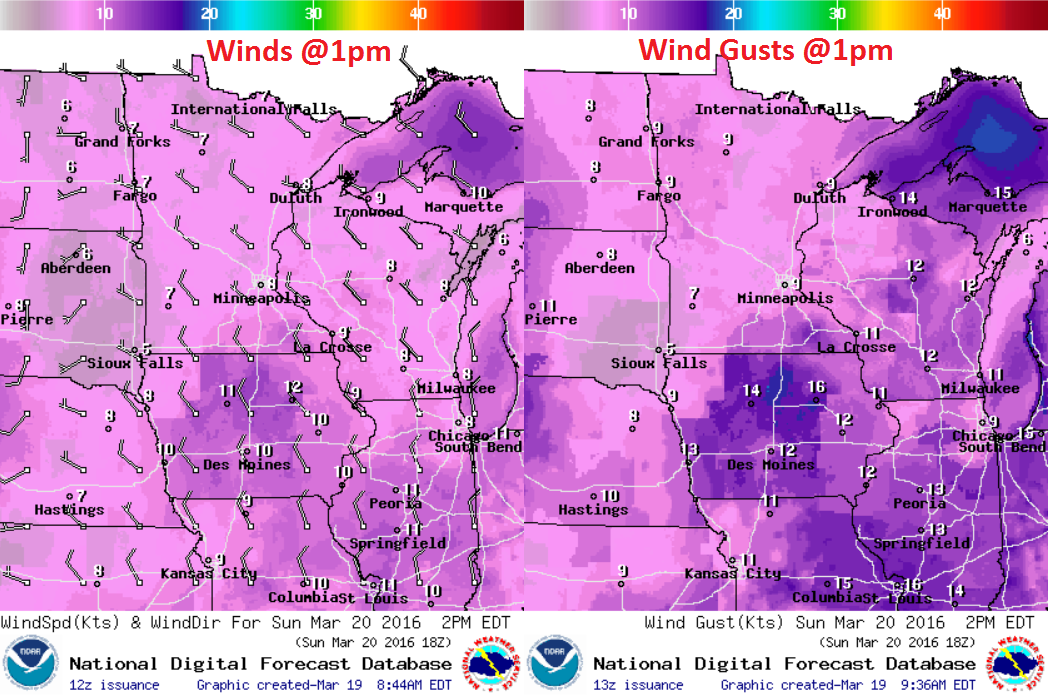
Sunday Weather Outlook
The good news is that winds won't be quite as biting as they were earlier this week. A light northwesterly breeze looks to continue through Sunday night before turning more southeasterly on Monday.
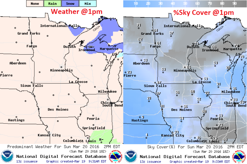
Sunday Weather Outlook
Sunday appears to be a little brighter across the region with lingering clouds. There may be a few light snow showers near Lake Superior, but nothing looks significant.
Simulated Radar
The weak system that brought us a little light early Saturday will continue to drift south of the region on Sunday. Note the next system that looks to move into the far northern part of the state Monday. There may be some minor snow accumulations along the international border through Tuesday.
___________________________________
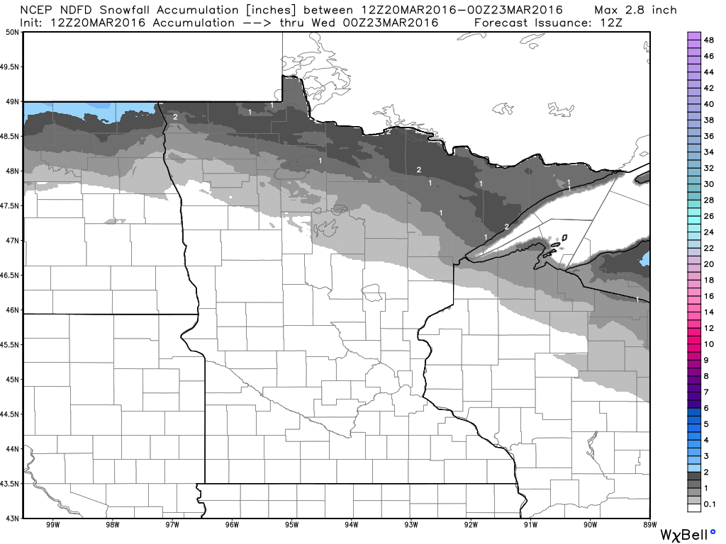
Snowfall Potential
The snowfall potential suggests light snowfall amounts along the international border with some 1" to near 2" tallies possible through 7pm Tuesday.
_________________________________
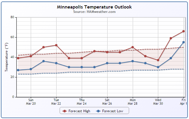
Minneapolis Temperature Trend
The extended forecast keeps temperatures in Minneapolis pretty consistently close to average highs through much of next week. However, note the slight warm up early next week into the 50s prior to falling back to near normal levels through the rest of the week.
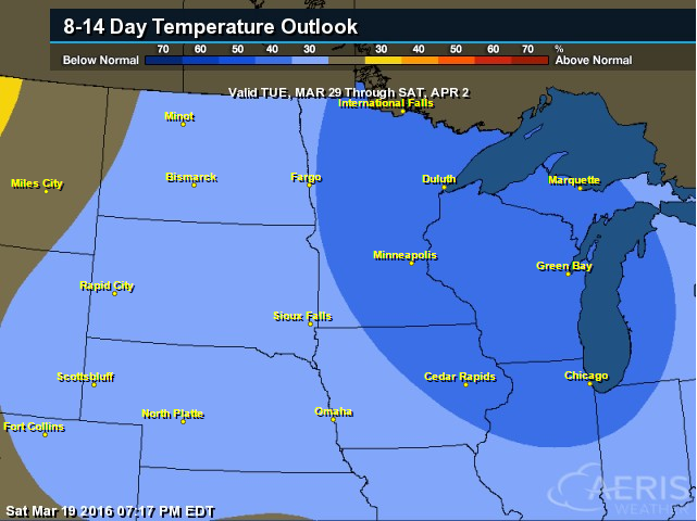
8 to 14 Day Temperature Trend
According to NOAA CPC, the 8 to 14 day temperature outlook suggests cooler than average temperatures will be possible across the Midwest/Great Lakes region by the end of the month...
______________________________
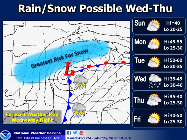
Snow Risk This Week?
Latest model runs are hinting at a potential weather system to impact the Midwest midweek with snow possible on the northern side of the area of low pressure. There is still much uncertainty as the actually storm is still located in the Eastern Pacific, so lots could change before then... stay tuned!
"The next few days will be dry, but a strong weather system could bring rain and snow to the area Wednesday and Wednesday night. Accumulating snow is possible."
(Image courtesy: NWS Twin Cities)
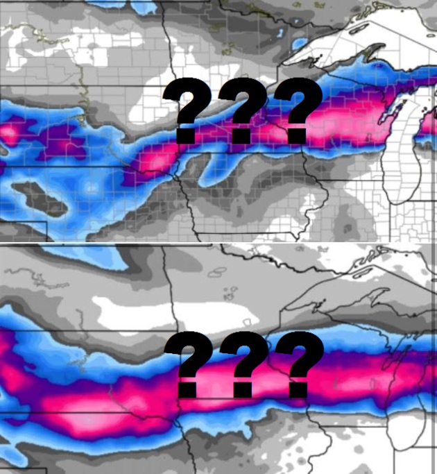
Increasing Snow Potential???
Here are two different models that are suggesting 'something' moving through the Midwest by midweek... It's important to keep in mind that it's still too early to get specific on timing or potential snowfall amounts. However, keep an eye on weather forecasts as we approach next week.
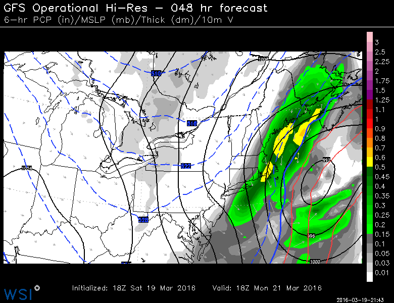
Northeast Snowfall Potential
As we continue tracking the storm along the East Coast, it appears that locations along the coast from Long Island to eastern Mass. and parts of Maine will likely see accumulating snow through the early week time frame.
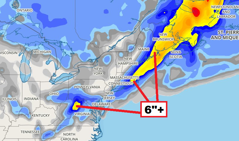
Northeast Snow Potential
Here's the northeast snowfall potential, which suggests some near 6"+ tallies possible along the East Coast through early next week...
________________________________
National Weather Outlook
The storm along the East Coast will quickly move north through the early next week with weather conditions subsiding by Tuesday. Meanwhile, a much larger surge of moisture looks to move into the Western U.S. with heavy rain and high elevation snow potential.
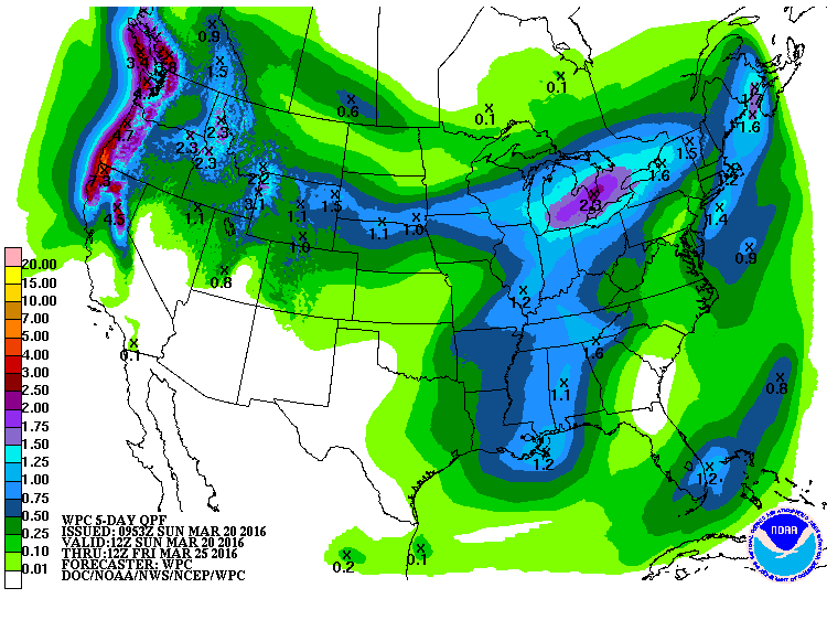
5 Day Precipitation Outlook
According to NOAA's WPC, the 5 day precipitation outlook suggests heavy moisture possible from northern California to the Pacific Northwest with some near 3" to 6"+ possible! Also note the heavier moisture across the Great Lakes Region, this is in response to the midweek storm system that may develop with heavier snow potential on the northern side of the storm... Stay tuned for more on that later this week.
________________________________________
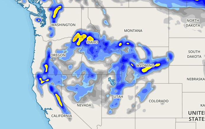
Western Snowfall Potential
Some spots in the Western U.S. have seen significant moisture so far this month and we're not quite done... here's the snowfall potential through early next week. Note that some in the higher elevations could see 6"+ (yellow).
_________________________________
Waterspout in Fort Lauderdale Beach, FL
Saturday was somewhat stormy across parts of Central/Southern Florida with a number of wind damage reports. However, take a look this waterspout that was captured in Fort Lauderdale Beach, FL!
See the video from @patrickm954 HERE:

Saturday Storm Reports in Florida
A number of wind damage reports came in on Saturday as storms developed during the afternoon.
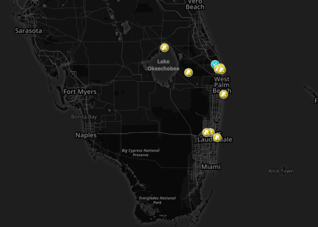
Saturday Storms in Florida
Here's the radar loop from Saturday afternoon as thunderstorms developed across parts of Central/Southern Florida.
Emails, Tweets Too Causing Climate Change
Who knew?? Here's an interesting article from Economictimes.indiatimes.com
"Biking or carpooling to work, eating less meat, turning down the thermostat a notch in winter, becoming an 'eco-responsible' consumer - these are some of the many ways folks can make a small difference, especially in rich countries with higher per-capita CO2 emissions. At the same time, however, a parallel realm of carbon-polluting activity - ranging from email exchanges to social network chatter (tweets, posts etc) to streaming movies on smartphones - has slipped largely unnoticed under the climate change radar. In isolation, these discrete units of our virtual existence seem weightless and without cost. A short email, for example, is estimated to add about four grams of CO2-equivalent (CO2e) into the atmosphere. By comparison, humanity emits some 40 billion tonnes of CO2 every year. But as the digital era deepens, the accumulated volume of virtual messages has become a significant part of humanity's carbon footprint."
Read more from Economictimes.indiatimes.com HERE:
(Image credit: pirweb.org)

_____________________________________
Thanks for checking in and have a great rest of your weekend! Don't forget to follow me on Twitter @TNelsonWX

No comments:
Post a Comment