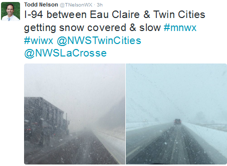
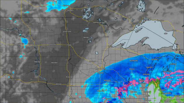
Snowy Commute Home (In Parts Of The Metro) Wednesday
For
those in parts of the south and east metro, it was a very slow commute
home due to snow falling Wednesday evening across the area. Meanwhile,
many in the north and west metro had a nice commute home with barely any
snow falling. It's amazing to see where the cutoff of the snow occurs
with storm systems like these. It's also very hard to forecast!
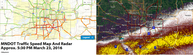
Snow Totals Through 6:30 PM

While
we still have a bit of snow to go through, here were the snow totals
across the metro as of 6:30 PM Wednesday evening. 10" of snow had
already reported in Burnsville and Prior Lake, with 9" in Cottage Grove
and 8" in Inver Grove Heights. However, go toward the west or north part
of the metro and not much had fallen - only 0.9" in North St. Paul and
0.3" in Minnetonka.
_______________________________________________
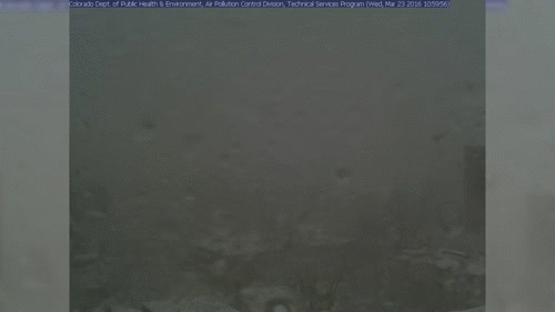 Just
be glad you weren't in Denver today, which saw blizzard conditions
throughout the day. You can't even see the city in this webcam
timelapse loop from about 11 AM to 2 PM local time today as the webcam was coated with snow.
Just
be glad you weren't in Denver today, which saw blizzard conditions
throughout the day. You can't even see the city in this webcam
timelapse loop from about 11 AM to 2 PM local time today as the webcam was coated with snow.
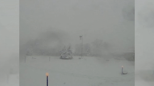 This webcam timelapse view from Lakewood, CO (just to the southwest of Denver)
showed the very gusty winds and new snow they received Wednesday. This
is part of the same system that brought us snow Wednesday into early
Thursday across the Twin Cities and southern Minnesota.
This webcam timelapse view from Lakewood, CO (just to the southwest of Denver)
showed the very gusty winds and new snow they received Wednesday. This
is part of the same system that brought us snow Wednesday into early
Thursday across the Twin Cities and southern Minnesota.
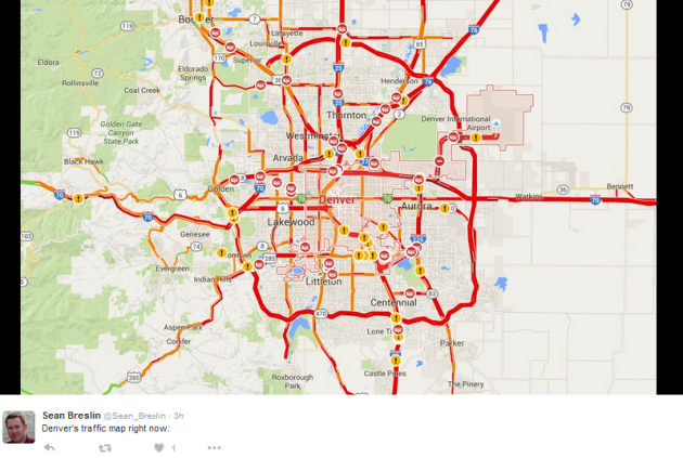 The
combination of heavy snow and blizzard conditions led to road
conditions quickly deteriorating in the Denver metro during the day
today - lots of red on the traffic map.
The
combination of heavy snow and blizzard conditions led to road
conditions quickly deteriorating in the Denver metro during the day
today - lots of red on the traffic map.
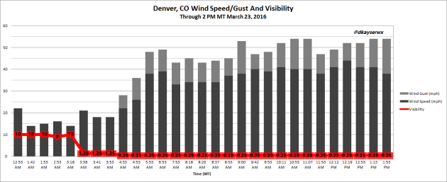 Here
were the conditions that people in Denver had to deal with throughout
the morning and into the afternoon Tuesday in Denver - visibility
dropped to a quarter mile with sustained winds of at least 35 mph and wind
gusts over 50 mph at times. Blizzard criteria is met when you have
sustained winds of 35 mph or greater with visibility down to at least a
quarter mile for at least three hours - and they certainly exceeded it.
Here
were the conditions that people in Denver had to deal with throughout
the morning and into the afternoon Tuesday in Denver - visibility
dropped to a quarter mile with sustained winds of at least 35 mph and wind
gusts over 50 mph at times. Blizzard criteria is met when you have
sustained winds of 35 mph or greater with visibility down to at least a
quarter mile for at least three hours - and they certainly exceeded it.
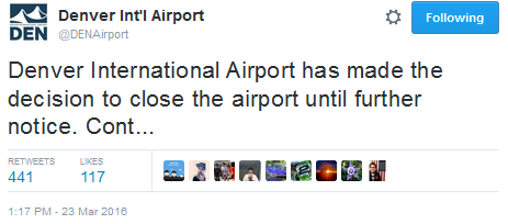 The
conditions were so bad in Denver, the International Airport was shut
down. Due to the blizzard conditions, the visibility was unsafe for
planes to arrive or depart from the airport. Pena Boulevard, which takes
you to DIA, was also impassable.
The
conditions were so bad in Denver, the International Airport was shut
down. Due to the blizzard conditions, the visibility was unsafe for
planes to arrive or depart from the airport. Pena Boulevard, which takes
you to DIA, was also impassable.
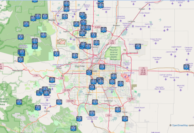 While
the Denver International Airport only saw 7.6" of snow, it was measured
in feet in parts of the metro area. There was a 25.5" amount reported
just east of Boulder, and 18" reported a few miles southeast of Denver.
While
the Denver International Airport only saw 7.6" of snow, it was measured
in feet in parts of the metro area. There was a 25.5" amount reported
just east of Boulder, and 18" reported a few miles southeast of Denver.
Sunset: 7:31 PM
*Length Of Day: 12 hours, 23 minutes and 40 seconds
*Daylight Gained Since Yesterday: ~3mins & 9secs
*Next Sunrise That Is Before 7 AM: March 29th (6:58 am)
*Next Sunset That Is After 8 PM: April 16th (8:01 pm)
National Outlook
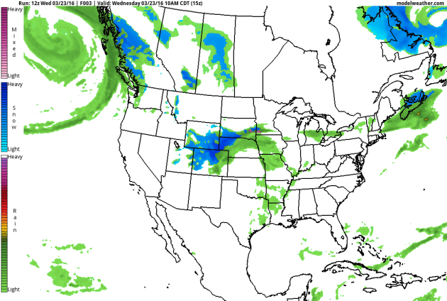 While
we watch the system that brought us snow depart off to the east, snow
will continue to be possible across parts of the Great Lakes and New
England Thursday, along with severe weather in the warm sector (more on
that in a moment). The frontal boundary associated with this system
moving across the country is expected to stall out over the southeast
late this week, bringing them unsettled weather into the weekend. The
next prominent system on our map is a clipper diving out of Canada as we
end the week, bringing some rain and snow to parts of the Rockies and
upper Midwest.
While
we watch the system that brought us snow depart off to the east, snow
will continue to be possible across parts of the Great Lakes and New
England Thursday, along with severe weather in the warm sector (more on
that in a moment). The frontal boundary associated with this system
moving across the country is expected to stall out over the southeast
late this week, bringing them unsettled weather into the weekend. The
next prominent system on our map is a clipper diving out of Canada as we
end the week, bringing some rain and snow to parts of the Rockies and
upper Midwest.
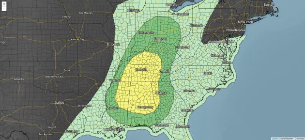
Severe threat Thursday. Graphic: AerisWeather
In
the warm sector of our departing storm Thursday, severe weather will
once again be likely from the Ohio Valley southward toward the Gulf
Coast. Large hail, damaging winds and a few tornadoes are possible.

It Could Be Worse: Denver Edition
_______________________________________________
No Worries: Forecast Calls for Rapid Melting
By Paul Douglas
By Paul Douglas
"It
was one of those March days when the sun shines hot and the wind blows
cold: when it is summer in the light, and winter in the shade" wrote
Charles Dickens in "Great Expectations". The arrival of spring is always
a sordid affair - flailing spasms of cold and snow amidst emboldened
warm fronts. Winter never goes quietly.
Tell
that to residents of southeastern Minnesota, clawing out from a cool
foot of slush. The MSP metro area was on the northern fringe of
accumulating snow. A sun angle as high in the sky as it was back on September 18
will melt most of the slush on your lawn today, as blue sky lures the
mercury to 40F. That's the beauty of a March snow: a quick photo-op,
then it's gone.
A weak frontal passage whips up a few showers late Friday into Saturday;
the atmosphere mild enough for a light rain-snow mix. No additional
accumulation is expected. Temperatures mellow into the 50s next week
with a few cracks of thunder by Wednesday.
NOAA
models show another chilly slap the weekend after next, but in general
heavy jackets will be increasingly rare in the weeks to come.
_______________________________________________
Extended Forecast for Minneapolis
THURSDAY: Partly sunny, brisk. High 40. Low 28. Precipitation Chance: 10%. Wind: N 10-15 mph.
FRIDAY: Clouds increase, late shower possible. High 44. Low 34. Precipitation Chance: 40%. Wind S 10-20 mph.
SATURDAY: Light mix, no accumulation expected. High 42. Low 29. Precipitation Chance: 50%. Wind NW 10-15 mph.
SUNDAY: More clouds than sun, drier day. High 45. Low 30. Precipitation Chance: 20%. Wind SW 7-12 mph.
MONDAY: Partly sunny and milder. High 48. Low 34. Precipitation Chance: 10%. Wind SE 7-12 mph.
TUESDAY
Breezy, late day showers. High 54. Low 42. Precipitation Chance: 50%. Wind SE 10-20 mph.
WEDNESDAY: Showers, chance of thunder. High 56. Low 38. Precipitation Chance: 70%. Wind S 15-25 mph.
_______________________________________________
This Day in Weather History
March 24th
1851: Minnesota experiences an early spring 'heat wave' with 60s and 70s common.March 24th
_______________________________________________
Average Temperatures & Precipitation for Minneapolis
March 24th
March 24th
Average High: 45F (Record: 76F set in 1939)
Average Low: 27F (Record: -8F set in 1965)
Average Precipitation: 0.07" (Record: 1.06" set in 1949)
Average Snowfall: 0.2" (Record: 6.8" in 1996)
________________________________________________
Average Low: 27F (Record: -8F set in 1965)
Average Precipitation: 0.07" (Record: 1.06" set in 1949)
Average Snowfall: 0.2" (Record: 6.8" in 1996)
________________________________________________
Sunrise/Sunset Times for Minneapolis
March 24th
Sunrise: 7:08 AMMarch 24th
Sunset: 7:31 PM
*Length Of Day: 12 hours, 23 minutes and 40 seconds
*Daylight Gained Since Yesterday: ~3mins & 9secs
*Next Sunrise That Is Before 7 AM: March 29th (6:58 am)
*Next Sunset That Is After 8 PM: April 16th (8:01 pm)
________________________________________________
Thursday Minnesota Weather Outlook
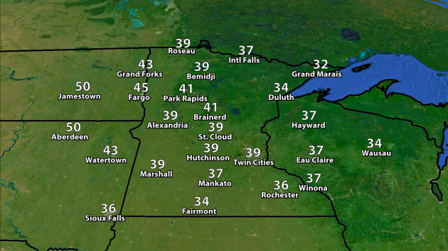
We'll
see temperatures stay cool across the region, only getting into the
upper 30s to maybe low 40s even with sunshine returning throughout the
day. Reason? The new snow pack. That's certainly evident in southern
Minnesota, where Fairmont is only expected to reach a high of 34. Where
there isn't snow on the ground, up toward Brainerd and Fargo, highs will warm into the low to mid 40s.
Forecast satellite and radar every three hours from 7 AM Thursday through 1 AM Friday. Graphic: AerisWeather
The system responsible for our snow will be on the way out
in the morning hours, and clearing skies will work into the Twin Cities
as we head toward the lunch hour (sooner if you are off to the north
and west). Skies should remain fairly clear through the afternoon hours
into the overnight.
________________________________________________
Severe threat Thursday. Graphic: AerisWeather
________________________________________________
Thanks for checking in and have a great Thursday! Don't forget you can follow me on Twitter (@dkayserwx) or on Facebook (Meteorologist D.J. Kayser)!
- D.J. Kayser
No comments:
Post a Comment