GOES Project Science
Want
to take a look at some amazing satellite imagery? Here's a great link
from NOAA's GOES Project Science that has all the latest satellite
images/loops... great bookmark!
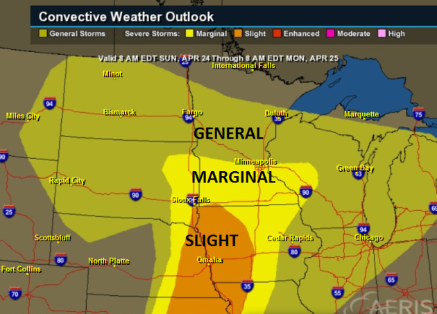
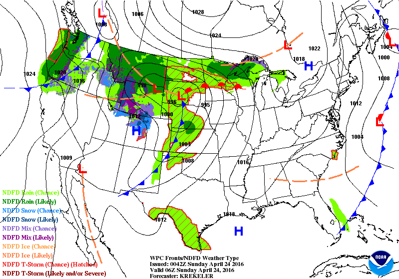
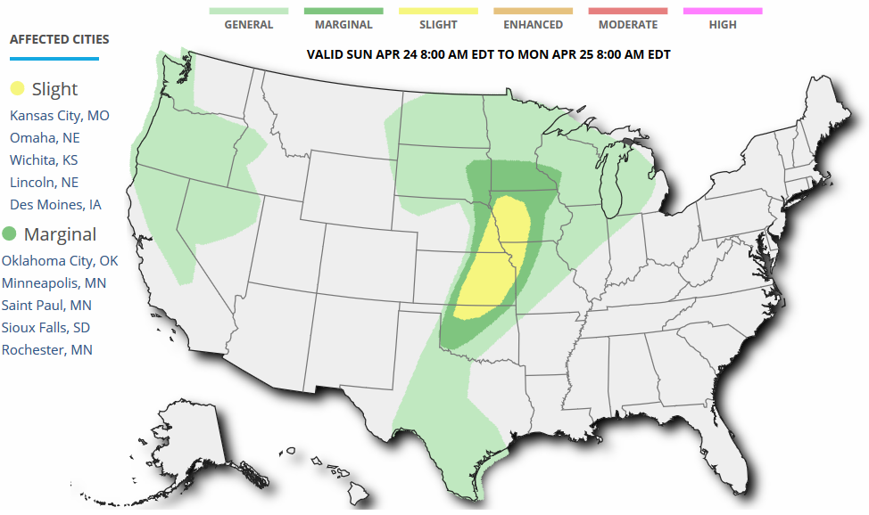
Sunday Severe Threat?
The
storm system responsible for our mild temperature outlook over the
weekend will also be responsible for some scattered shower and storm
development, mainly PM Sunday. In fact, the Storm Prediction Center has
issued a Marginal risk of severe weather across parts of southern MN for
Sunday. While it doesn't look like a major severe weather outbreak, a
few storms could be a little more vigorous later Sunday
afternoon/evening... Stay tuned.
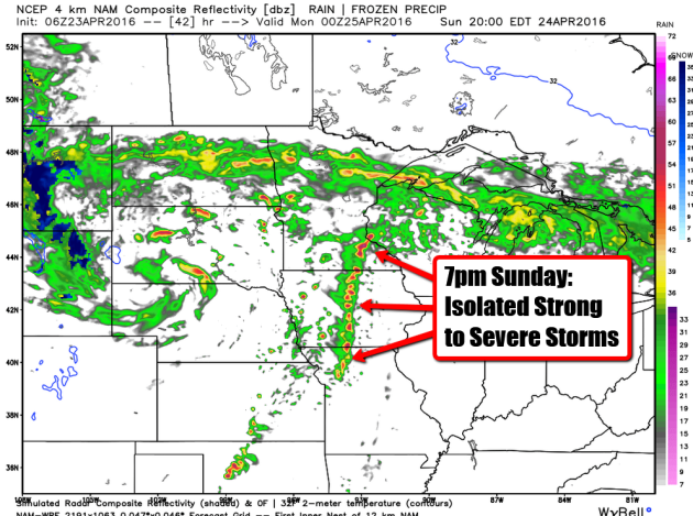
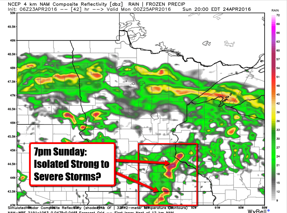
Radar Outlook for 7pm Sunday
Here's
what the simulated radar picture looks like by 7pm Sunday. While this
view is not 100% accurate of what will happen then, it's important to
watch weather trends as we head into the end of the weekend in case a few
strong to severe storms do decide to pop.
____________________________________
Somewhat Soggy Sunday - Scatter PM Thunder
By Todd Nelson, filling in for Douglas.
I'm beat. I wore myself out yesterday trying to pack in as much outdoor stuff as I could. Maybe Mother Nature is telling me to take it easy today. Cloudier skies and increased rain chances may be ideal napping weather. I see some Zzzs in my future.
Weather maps look active over the next several days. A series of Pacific storms will make the end of April a little more interesting for us. The first storm system will be with us through early next week. However, scattered showers and a few strong rumbles will flirt with southern Minnesota later today.
The next, more impressive storm system moves in by the middle part of next week. The Storm Prediction Center has highlighted Tuesday and Wednesday as potential severe weather outbreak days in the Central U.S. for several days now. It appears that Tuesday will feature the strongest of storms.
Extended rainfall forecasts are suggesting heavier moisture for us through the end of next week. This is good news! May flowers and recently fertilized lawns will be delighted.
Nap time...
_____________________
Extended Forecast
SATURDAY NIGHT: Mostly cloudy. Chance of thunder overnight. Winds: SE 10-15. Low: 55
SUNDAY: Breezy. Scattered showers and storms. Winds: ESE 10-15. High: 68.
SUNDAY NIGHT: Scattered showers, a few rumbles of thunder. Winds: NE 10-15. Low: 47.
MONDAY: Cloudy and wet, rumble of thunder. Winds: NE 10-15. High: 53.
TUESDAY: Mostly cloudy and cool, a few spits. Winds: ESE 10-15. Wake-up: 39. High: 56.
WEDNESDAY: Windy with cool rain showers. Winds: 10-20. Wake-up: 40. High: 52.
THURSDAY: Lingering clouds, few showers. Winds: ENE 10-15. Wake-up: 40. High: 54
FRIDAY: More sun, feels better. Winds: ESE 5-10. Wake-up: 40. High: 60.
SATURDAY: Breezy. Clouds thicken with PM rain. Winds: ESE 10-15. Wake-up: 43. High: 61.
_________________________
_________________________
This Day in Weather History
April 24th
April 24th
1854: It feels like summertime at Ft. Snelling with temperatures in the 80s..
_________________________
_________________________
Average High/Low for Minneapolis
April 24th
April 24th
Average High: 62F (Record: 84F set in 1962)
Average Low: 41F (Record: 24F set in 1875)
__________________________
Average Low: 41F (Record: 24F set in 1875)
__________________________
Sunrise/Sunset Times for Minneapolis
April 24th
April 24th
Sunrise: 6:12am
Sunset: 8:10pm
Sunset: 8:10pm
*Daylight gained since yesterday: ~2mins & 52secs
*Daylight gained since winter solstice: ~5hours & 12mins
______________________________
*Daylight gained since winter solstice: ~5hours & 12mins
______________________________
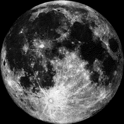
Moon Phase for April 24th at Midnight
3.1 Days After Full (Pink) Moon
3.1 Days After Full (Pink) Moon
________________________________
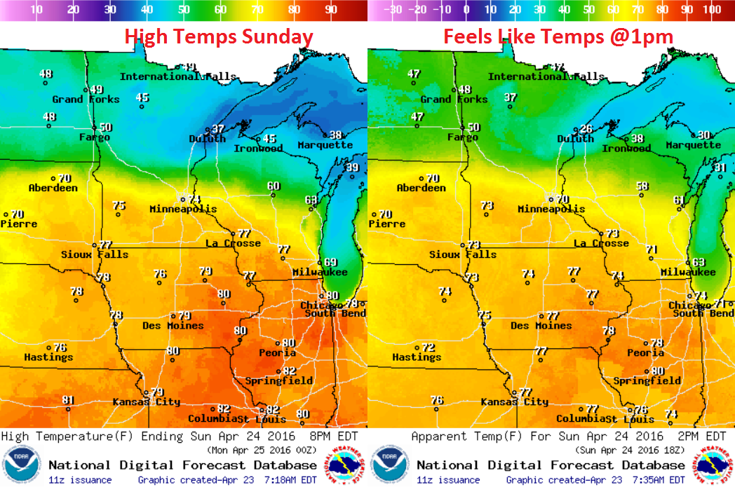
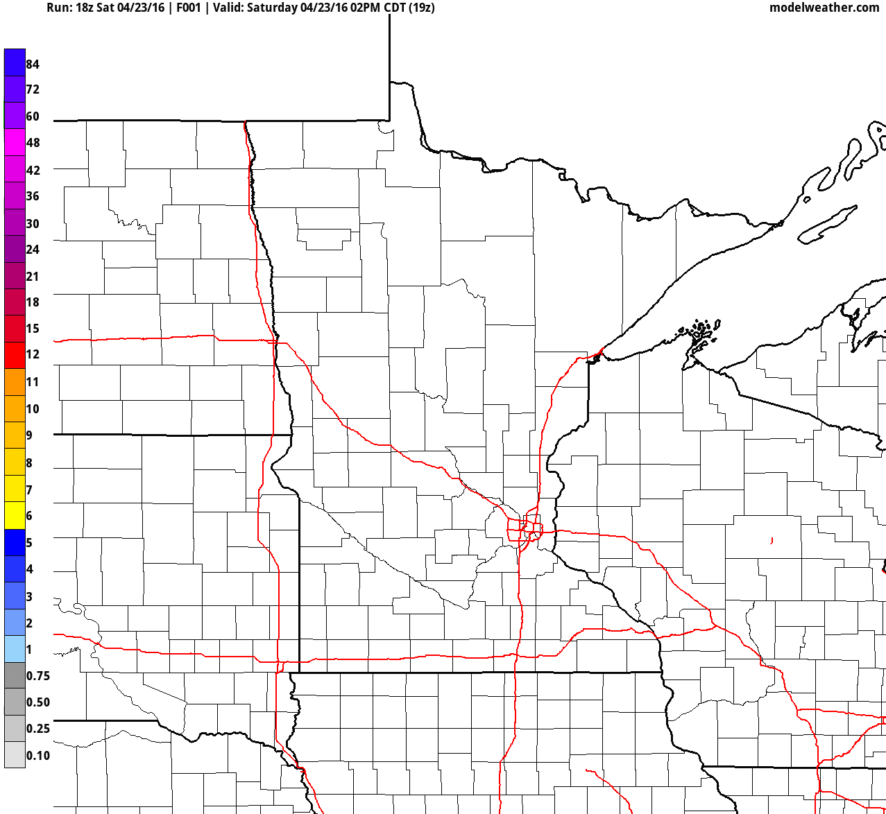
Sunday Weather Outlook
Highs
on Sunday will be quite divided across the state as a storm system
moves into the region. The sharp temperature contrast across the Dakota,
Minnesota and Wisconsin will be due to a warm front draped across the
area. Temperatures north of this warm front will generally be in the
40s, but highs south of the front will warm into the 70s!
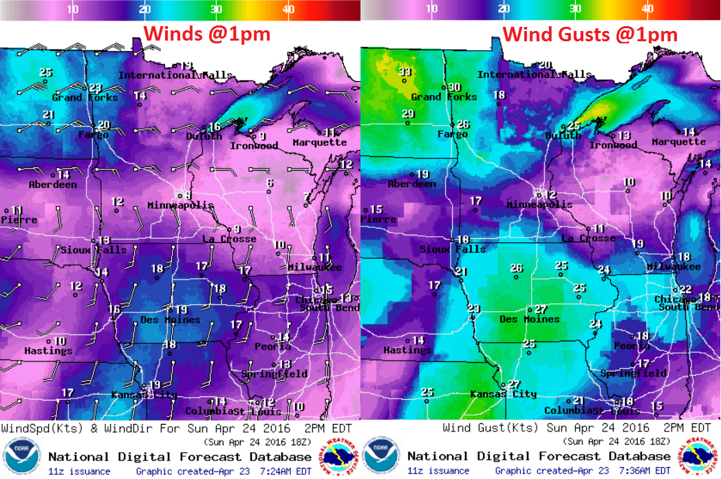
Sunday Weather Outlook
Note
the overall counter-clockwise flow across the region. The winds will be
circulating around a developing area of low pressure that will move
through the region through early next week. Winds and times may be gusty
as the storm system slides through.
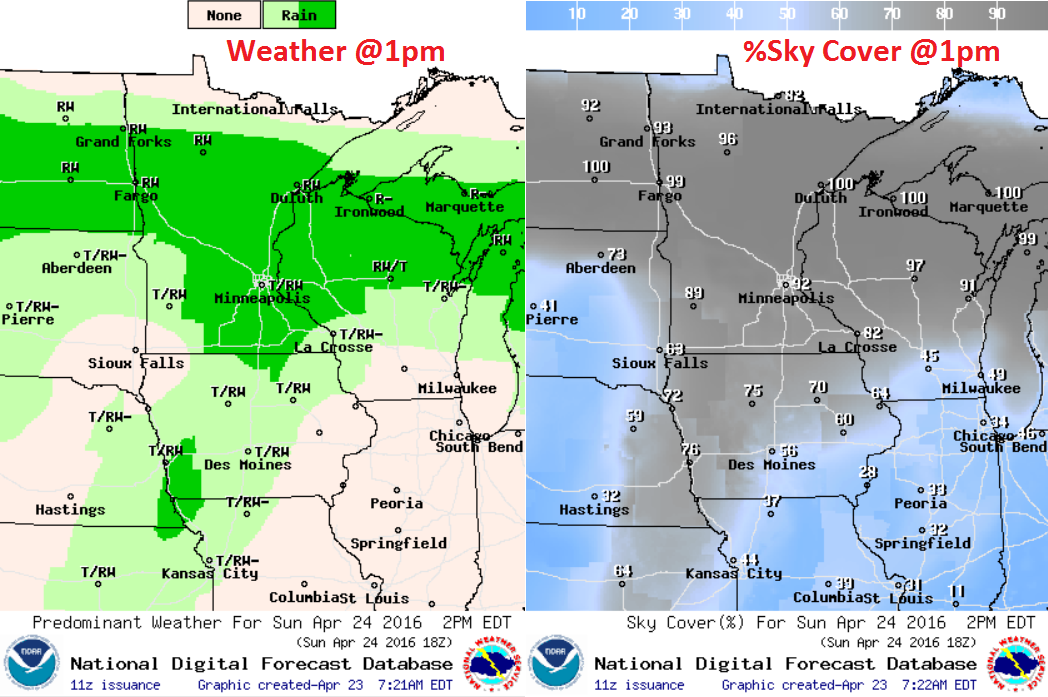
Sunday Weather Outlook
Weather
conditions look fairly wet along and north of the warm front. Note the
darker green color showing up from North Dakota through central/northern
Minnesota and into Wisconsin. This is where a steadier/colder rain will
be found with heavier rainfall tallies through Monday.
Simulated Radar
Here's
the simulated radar from PM Friday to midday Monday. Note that the
weekend looks to start off dry, but we should end on a fairly unsettled
note with scattered showers and storms developing later Sunday. A
lingering cold rain looks to continue on Monday with a wintry mix
possible across parts of northern Minnesota..
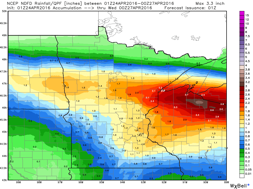
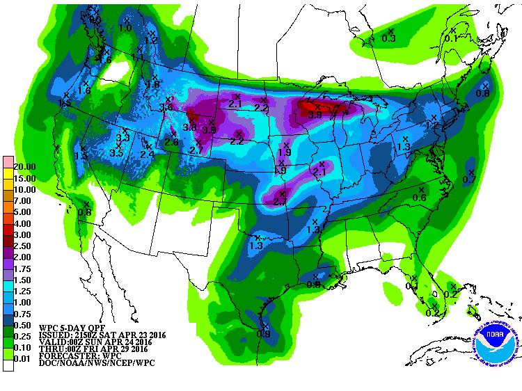
Precipitation Outlook
Here's
the precipitation outlook through 7pm Monday, which suggests some
steadier 1"+ tallies across parts of northern Minnesota and Wisconsin.
Some of this rain will be associated with thunderstorm activity,
especially Sunday. Interestingly, we're also getting indications that
some of this moisture could be in a light wintry fashion across parts of
the northern Minnesota by Monday.
__________________________________________
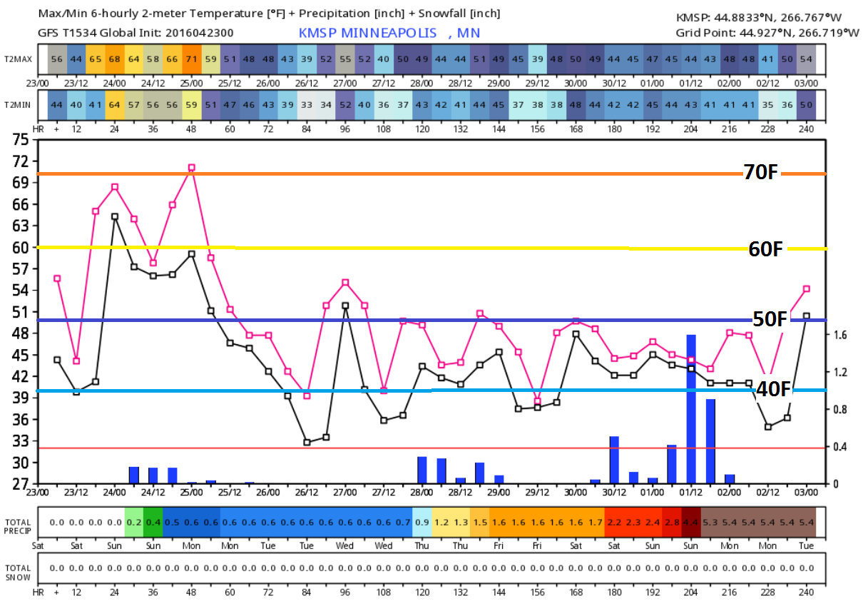
Extended Outlook
The
extended forecast through the end of April/early May shows warmer
temperatures this weekend before we see a bit of a dip next week. Highs
next week look to be in the 50s, perhaps even into the 40s across
northern Minnesota. Interestingly, we're getting indications that some
of the moisture that falls next week could fall in a wintry mixed
fashion.
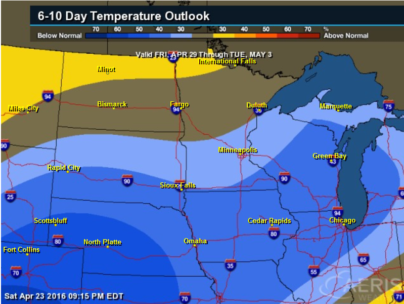
6 to 10 Day Temperature Outlook
According
to NOAA's CPC, the 6 to 10 day temperature outlook suggests a decent
chance of cooler than average temperatures across the Midwest by end of
the month/start of May.
____________________________
National Weather Outlook
The
national weather outlook through the early Monday shows our next storm
system sliding into the Midwest with a fairly substantial amount of
liquid. Note that some of the moisture will be related to convective
feedback (thunderstorms), but also note that there appears to be a bit
of a wintry mix showing up Monday morning across parts of northern
Minnesota! It appears that weather conditions stay fairly active into
next week with another storm system arriving by the middle and end of
next week.
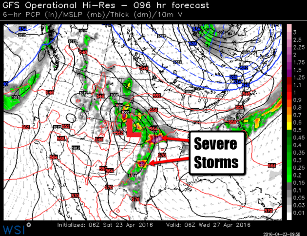
Severe Threat Sunday
...SUMMARY...
   STRONG TO SEVERE THUNDERSTORMS ARE POSSIBLE SUNDAY AFTERNOON AND
   EVENING ACROSS PARTS OF OKLAHOMA AND EASTERN KANSAS INTO THE MIDDLE
   MISSOURI VALLEY TO SOUTHERN MINNESOTA...AND ACROSS PARTS OF SOUTH
   TEXAS.

   ...SYNOPSIS...
   A WELL-DEFINED MID-UPPER-LEVEL SHORTWAVE TROUGH IS EVIDENT ON THE
   MOST RECENT WATER VAPOR LOOP OVER THE GREAT BASIN...AND THIS FEATURE
   WILL SHIFT EWD INTO THE CNTRL HIGH PLAINS BY 12Z SUN MORNING. A
   GENERAL WEAKENING/DEAMPLIFICATION OF THIS SHORTWAVE TROUGH WILL
   OCCUR WITH EWD PROGRESSION ACROSS THE CNTRL PLAINS AND MID-MO
   VALLEY...AS AN ASSOCIATED MIDLEVEL LOW LAGS ACROSS SD/NEB. THE
   PRIMARY AREA OF SFC CYCLOGENESIS WILL INITIALLY OCCUR ACROSS SD...IN
   VICINITY OF A PREEXISTING QUASI-STATIONARY W-E ORIENTED BOUNDARY
   ACROSS THE DAKOTAS. A DRYLINE WILL EXTEND SWD FROM THIS FEATURE
   ACROSS THE CNTRL PORTIONS OF NEB/KS...AND SHOULD SERVE AS ONE FOCUS
   FOR TSTM DEVELOPMENT DURING THE AFTERNOON. ADDITIONAL TSTMS ARE ALSO
   LIKELY ALONG/N OF THE QUASI-STATIONARY BOUNDARY EARLY IN THE
   PERIOD...WITH ADDITIONAL TSTM REDEVELOPMENT POSSIBLE ACROSS THE
   DAKOTAS INTO THE UPPER MS VALLEY DURING THE AFTERNOON/EVENING.

   ELSEWHERE...SUBSTANTIAL AMPLIFICATION OF A MID-UPPER-LEVEL TROUGH
   WILL OCCUR OVER THE WRN CONUS AS A POWERFUL SPEED MAX APPROACHES THE
   CA COAST. A SRN STREAM IMPULSE MOVING ACROSS NRN MX WILL REACH THE
   RIO GRANDE VALLEY SUN MORNING AND CONTRIBUTE TO INCREASED CONVECTIVE
   POTENTIAL OVER SOUTH TX.
5 Day Precipitation
Weather
conditions look quite active now as we head through the rest of April. A
series of Pacific storms will roll through the country and intensity
across the Central U.S.. Scattered showers and storms (some severe) will
result in heavier precipitation potential, mainly across the northern
tier of the nation. There will also be areas of snow, some of which
could accumulate to shovelabe amounts, mainly in the higher elevation in
the Western U.S.
Snowfall Potential?
Here's
the snowfall potential through the end of April according to the GFS
model. Note that most of the accumulations will be found across the
higher elevations in the Western U.S., however, note that it is showing
some minor slushy stuff from parts of the Upper Midwest to the Great
Lakes. While it doesn't appear to be much, it would indicate that
temperatures would be chilly down to below average levels for this to
occur. So next week looks a little chiller than we've seen in recent
days.
___________________________
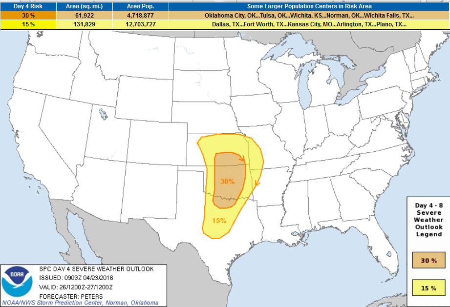
Upcoming Severe Weather Concerns Next Week
...DISCUSSION...
   CONCERN FOR A MORE ACTIVE SPRINGTIME SEVERE WEATHER PATTERN
   CONTINUES WITH THIS OUTLOOK ISSUANCE FOR THE CENTRAL AND SOUTHERN
   PLAINS ON DAY 4/TUESDAY AND INTO THE MID MS VALLEY TO NORTHEAST TX
   REGION ON DAY 5/WEDNESDAY.
Severe Threat Tuesday, April 26th
...DAY 4/TUESDAY...
   THE GREATEST THREAT FOR SEVERE WEATHER APPEARS TO BE ON DAY 4/TUE.
   DETERMINISTIC AND ENSEMBLE GUIDANCE CONTINUES TO BE IN FAIRLY GOOD
   AGREEMENT...INDICATING INGREDIENTS IN PLACE FOR A POTENTIAL SEVERE
   WEATHER OUTBREAK ACROSS PORTIONS OF THE SOUTHERN/CENTRAL PLAINS
   TUESDAY AFTERNOON/EVENING.  A STRONG UPPER TROUGH OVER THE WESTERN
   STATES WILL BECOME NEGATIVELY TILTED WHILE PIVOTING EAST TOWARD THE
   PLAINS.  A 50-60+ KT SOUTHWESTERLY MIDLEVEL JET WILL OVERSPREAD NM
   INTO WRN TX/OK AND KS BY TUESDAY AFTERNOON.  AT THE SURFACE...A LEE
   CYCLONE WILL DEVELOP OVER EASTERN CO AND SHIFT TO THE EAST/NORTHEAST
   INTO CENTRAL AND OR NORTHWEST KS.  A SHARP DRYLINE WILL EXTEND SOUTH
   THROUGH SOUTHWEST/SOUTH-CENTRAL KS THROUGH WESTERN OK TO
   WEST-CENTRAL TX.  MEANWHILE...A WARM FRONT SHOULD BE DRAPED ACROSS
   NRN KS INTO THE MID-MS VALLEY.  MODEL VARIABILITY WITH THE PLACEMENT
   OF THE SURFACE LOW...WARM FRONT AND DRY LINE HAS RESULTED IN WEST
   AND NORTHWEST EXPANSIONS OF THE 15% AND 30% SEVERE-WEATHER THREAT
   AREAS.

   SOUTH/SOUTHEASTERLY LOW LEVEL FLOW WILL TRANSPORT MID 60S TO NEAR 70
   DEW POINTS NORTHWARD ACROSS THE WARM SECTOR...WITH MODERATE TO
   STRONG INSTABILITY IN PLACE BY AFTERNOON.  STEEP MIDLEVEL LAPSE
   RATES AND STRONG...VERTICALLY VEERING SHEAR PROFILES WILL FAVOR
   SUPERCELLS CAPABLE OF ALL SEVERE HAZARDS INCLUDING VERY LARGE HAIL
   AND TORNADOES.  THESE THREATS ARE EXPECTED TO PERSIST TUESDAY
   EVENING ACROSS THE CENTRAL AND SOUTHERN PLAINS AS STRONGER
   FORCING/HEIGHT FALLS SPREAD ACROSS THESE AREAS.
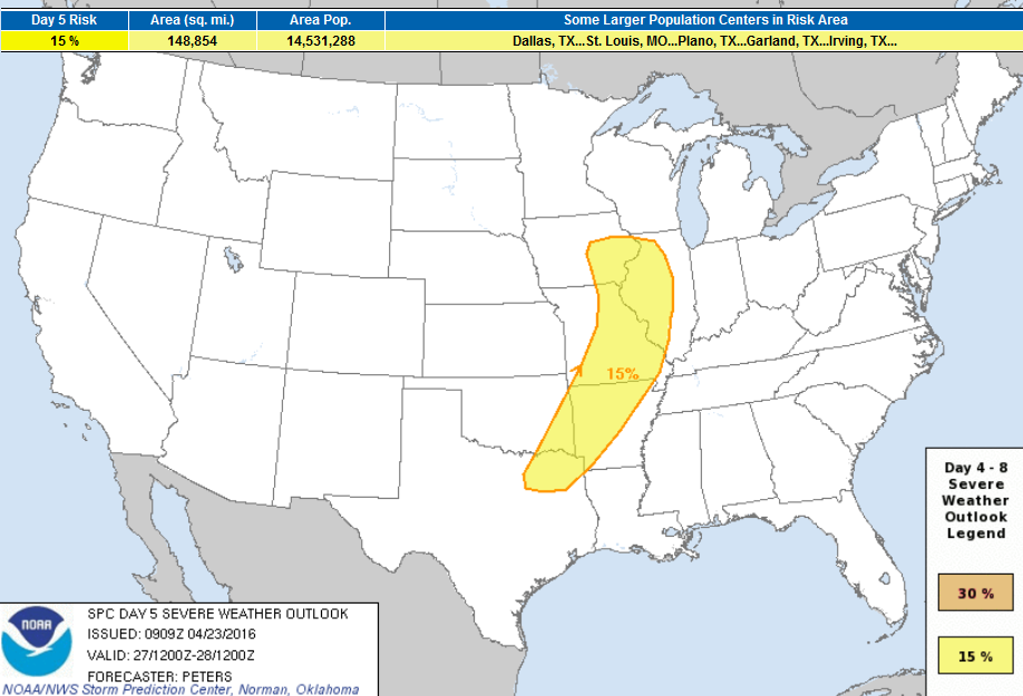
Severe Threat Wednesday, April 27th
...DAY 5/WEDNESDAY...
   THE SEVERE THREAT IS EXPECTED TO SHIFT EASTWARD ON DAY 6/WED ACROSS
   PARTS OF THE MIDDLE MS VALLEY TO NORTHEAST TX AHEAD OF THE
   EASTWARD-ADVANCING SURFACE LOW AND COLD FRONT.  CONVECTION WILL
   LIKELY BE ONGOING WEDNESDAY MORNING ACROSS EASTERN PARTS OF THE
   CENTRAL AND SOUTHERN PLAINS INTO THE MID-MS VALLEY.  THE FORECAST
   CAPE/SHEAR PARAMETER SPACE ACROSS THE WARM SECTOR SUGGESTS A 15%
   SEVERE-WEATHER THREAT AREA REMAINS WARRANTED FROM THE MID MS VALLEY
   TO THE NORTHEAST TX REGION FOR WEDNESDAY AFTERNOON AND
   EVENING...WITH ALL SEVERE HAZARDS POSSIBLE.
...DAY 6/THURSDAY - DAY 7/FRIDAY...
   WHILE THERE IS SOME MODEL VARIABILITY IN THE TRACK OF THE CENTRAL
   U.S. TROUGH AND SURFACE FEATURES DURING DAYS 4 AND 5...THE MODEL
   SPREAD INCREASES LATE THIS WEEK.  ALTHOUGH STRONG TO SEVERE STORMS
   COULD OCCUR ON DAY 6/THURSDAY ACROSS THE MIDWEST/OH VALLEY...MODEL
   SYNOPTIC VARIABILITY RESULTS IN DIFFERING LOW-LEVEL MASS RESPONSES
   AND DEGREE OF DESTABILIZATION.  THEREFORE...NO SEVERE PROBABILITY
   AREA WILL BE DELINEATED FOR DAY 6 IN THE MIDWEST/OH VALLEY.

   MEANWHILE...MODELS ARE IN GENERAL AGREEMENT FARTHER WEST SHOWING AN
   MID- TO UPPER-LEVEL TROUGH DEEPENING ACROSS THE GREAT BASIN INTO THE
   NORTHWEST MEXICO ON DAY 6/THU AND SHIFTING EAST INTO THE CENTRAL/
   SOUTHERN ROCKIES AND NORTHERN MEXICO ON DAY 7/FRI.  THIS UPPER
   PATTERN WILL RESULT IN SOUTHWEST FLOW EXTENDING ACROSS THE DRY LINE
   IN WEST TX ON THURSDAY AND FRIDAY...AND POSSIBLY INTO WESTERN KS ON
   FRIDAY AS WELL.  THIS SCENARIO WOULD SUPPORT STRONG TO SEVERE STORM
   DEVELOPMENT ALONG THE DRY LINE...BUT UNCERTAINTY IN THE STRENGTH OF
   LOW-LEVEL CONVERGENCE AND TIMING OF ANY MIDLEVEL IMPULSES PRECLUDES
   THE INTRODUCTION OF 15% SEVERE PROBABILITIES FOR THU/FRI.
_____________________________________________
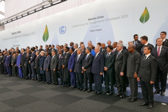
Paris Agreement Offers New Climate Covenant with Future
"NEW YORK—U.N. Secretary-General Ban Ki-moon this morning declared the signing today of the Paris Agreement on climate change “a new covenant with the future.” Addressing a crowded assembly at U.N. headquarters, Ban said leaders from a record 171 nations have gathered to officially sign onto the landmark deal. It is, he said, the largest number of countries to ever sign onto an international agreement on a single day. Secretary of State John Kerry will address the gathering shortly, as well as French President François Hollande and leaders from China, India and dozens of other nations. “We are breaking records in this chamber. But records have also been broken outside,” Ban said. “Record global temperatures, record ice loss, record carbon levels in the atmosphere. We are in a race against time. I urge all countries to move quickly to join the agreement at the national level so the Paris Agreement can enter into force as early as possible.” Environmental groups quickly heaped praise on the festivities but said the ceremony is the start of what will be decades of hard work."Read more from ScientificAmerican.com HERE:
(Image Credit: Presidencia de la República Mexicana/Flickr, CC BY 2.0 via ScientificAmerican.com)
The Key Players in Climate Change
Diplomats from at least 167 countries are gathering in New York to sign the climate accord reached in December in Paris. Whether they make good on their pledges to slow dangerous greenhouse gas emissions will depend in large part on the actions in the years ahead by the world’s largest polluters. A status report on the key players follows.
Read more from NYTimes.com HERE:
(Image Courtesy: Spencer Platt/Getty Images via NYTIMES.com)
Thanks for checking in and have a great rest of your week and weekend ahead!
Follow me on Twitter @TNelsonWX
Follow me on Twitter @TNelsonWX

No comments:
Post a Comment