85 F. high in St. Cloud Sunday.
80 F. average high on June 26.
82 F. high on June 26, 2015.
June 27, 1908: A tornado hits Clinton in Big Stone County.
A Comfortable Week - Pondering What Can Go Wrong on the 4th of July
"Life is a long preparation for something that never happens" said Yeats. After a time one learns to embrace dashed expectations.
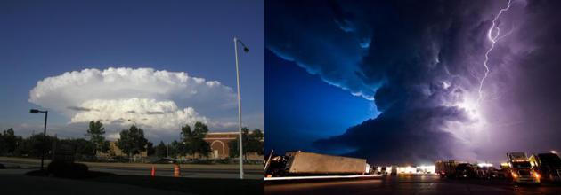
Every year I imagine the 4th of July in Norman Rockwell pastels: kids waving flags, laughter on the lake, a quick family photo in front of the setting sun before the oohs and aahs of fireworks. The reality many years? Running and screaming; chased by vile bugs - or swarms of atmospheric mushroom clouds; lines of flickering storms piled up on the horizon - like some imminent invasion of alien fireflies.
Enjoy comfortable air this week as Canada donates low dew points & fresh breezes with a string of days in the 70s and nights in the 50s. A reinforcing cool front may spark showers Thursday, otherwise its a mainly dry forecast into the 4th of July.
The most comfortable weather of the holiday weekend comes Friday & Saturday (you may need a sweatshirt after dark up north). 80s return Sunday and the 4th of July; ECMWF guidance hinting that storms may hold off until next Tuesday as 90s return.
In fact long-range models hint a streak of 90s by mid-July.
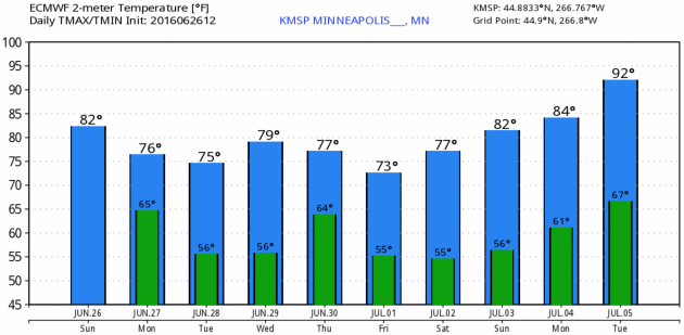
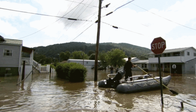
Photo credit: "West Virginia State Trooper C.S. Hartman uses a boat to navigate the flooded streets of Rainelle, W. Va., on Saturday, June 25, 2016." CBS News.
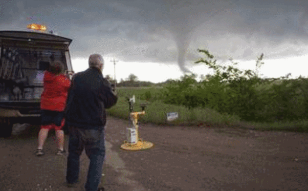
Atmospheric Scientists Boldly Go Into The Heart of a Tornado. The National Science Foundation has the story; here's an excerpt: "...TWIRL’s
field season ran from May 1 through June 15. That's the time of year
when two ingredients required for tornadoes -- very unstable air and
strong vertical wind shear -- are most common. The TWIRL scientists are
developing 3-D maps of the strongest tornado winds near the ground, and
studying how these winds cause damage to buildings, power lines, trees
-- and anything else in their way. "TWIRL researchers are focusing on
low-level winds flowing into the cores of tornadoes," said Ed Bensman,
program director in NSF's Division of Atmospheric and Geospace Sciences,
which funds TWIRL..."
Photo credit: "TWIRL researchers get a tornado pod set-to-go; a tornado is about to pass by." Credit: Center for Severe Weather Research/Robin Lorenson.
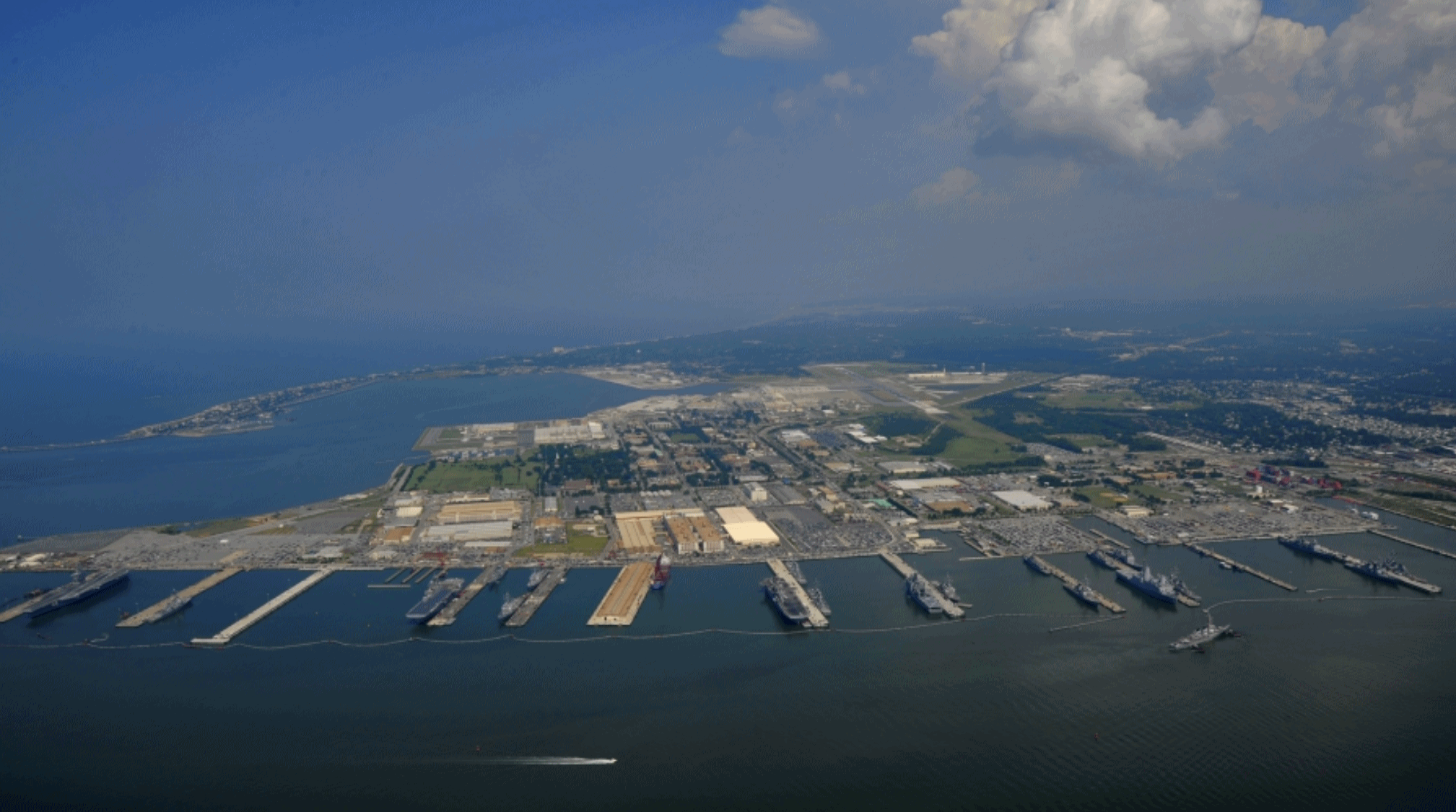
Photo credit: "Naval Station Norfolk may experience as much as six feet of relative sea-level rise by the end of the century. Defense officials are beginning to work with nearby city governments to ensure vital infrastructure is protected." Credit: Navy handout obtained by Reuters in 2013.
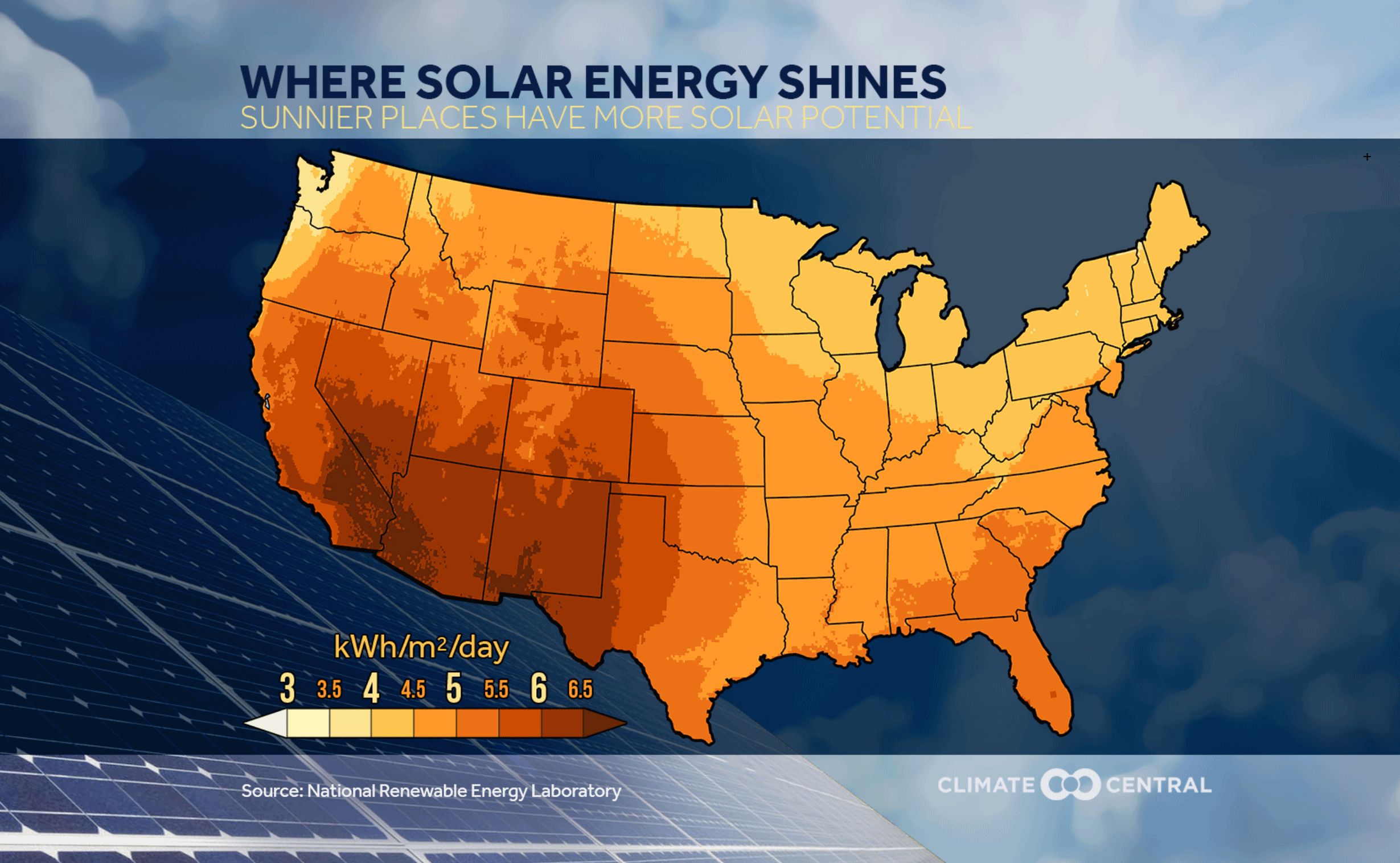
Here's Where Solar Energy Shines in the U.S. Climate Central has the story - here's a clip: "...The
price paid for electricity varies across the country, depending on how
it is generated and other factors. But according to the Department of
Energy, the average national price of electricity to residential
customers is about 12 cents per kWh. If a home gets 400 kWh a month from
solar, it would cut the annual energy bill for the average home by
around $600. Since 2008, the cost of generating electricity from solar
panels has been cut in half. The number of U.S. solar installations have increased by a factor of 17 over that period, and they now have the capacity topower the equivalent of 4 million average American homes.
With solar panel costs expected to continue falling, solar energy may
become an increasingly attractive proposition to homeowners..."
TODAY: Some sun, cool wind. Winds: NW 10-20. High: 73
MONDAY NIGHT: Partly cloudy and cool for late June. Low: 56
TUESDAY: Hints of September. Bright sunshine, less wind. Winds: NW 3-8. High: 76
WEDNESDAY: Partly sunny and milder. Winds: S 7-12. Wake-up: 61. High: 80
THURSDAY: Showers likely, possible thunder. Winds: N 8-13. Wake-up: 64. High: 78
FRIDAY: Sunny, comfortably cool. Winds: E 5-10. Wake-up: 57. High: 75
SATURDAY: Blue sky, low dew points (50s). Winds: SE 7-12. Wake-up: 56. High: 79
SUNDAY: Sunny, warmer for lake stuff. Winds: SE 10-20. Wake-up: 58. High: 82
Climate Stories...
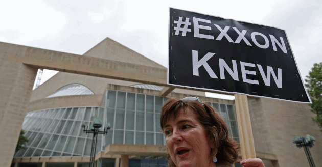
Exxon Mobil Is Abusing the First Ammendment. Here's an excerpt of a Washington Post Op-Ed from the Dean of the Yale Law School: "...If
ExxonMobil has committed fraud, its speech would not merit First
Amendment protection. But the company nevertheless invokes the First
Amendment to suppress a subpoena designed to produce the information
necessary to determine whether ExxonMobil has committed fraud. It thus
seeks to foreclose the very process by which our legal system acquires
the evidence necessary to determine whether fraud has been committed. In
effect, the company seeks to use the First Amendment to prevent any
informed lawsuit for fraud...."
Photo credit: "Activist Danna Miller Pyke protests near the Dallas site where the ExxonMobil annual shareholder meeting is taking place in May." (Jae S. Lee/The Dallas Morning News via Associated Press).
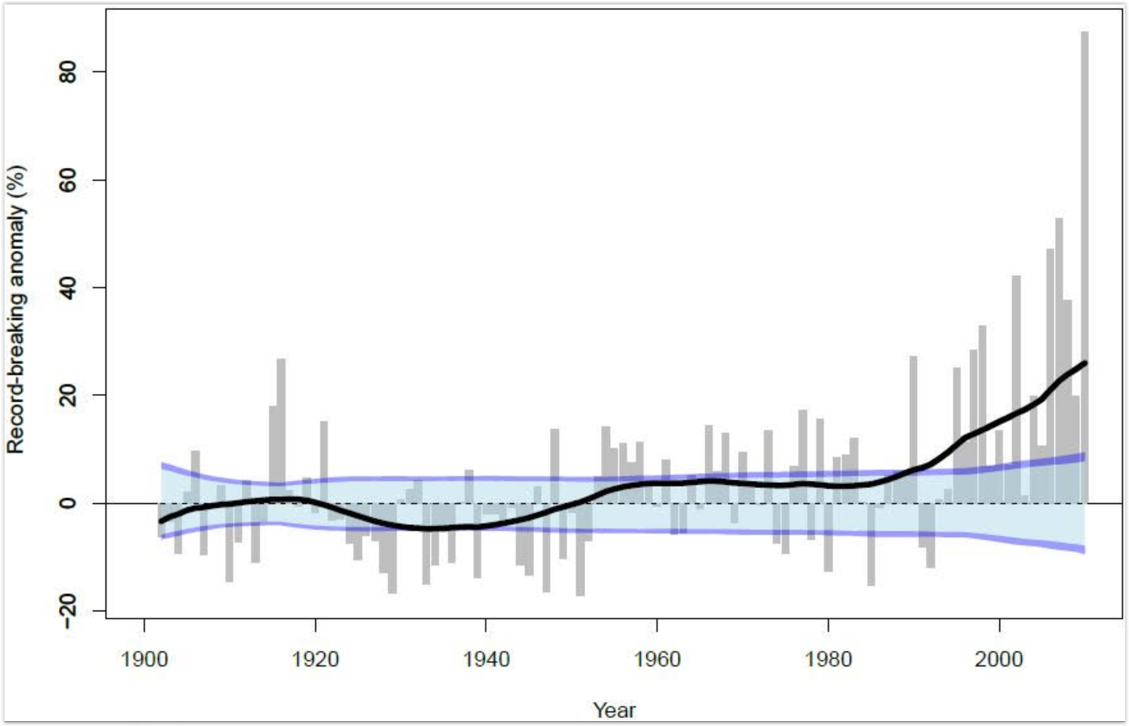
Not Just West Virginia. It's a Hard Rain Fallin'. No, it's not your imagination - warm season rains are falling harder, worldwide. Here's an excerpt from Climate Denial Crock of the Week: "...So
not only does a loading up of the hydrological cycle with moisture
result in heavier rainfall events generally, it also results in a
greater fraction of overall rainfall coming in the form of heavy rain.
In other words climate change causes heavier rain on top of heavier
rain. The worst events, as a result do not just get worse, they get
much, much worse. And this is due to the added convection — or updrafts —
that keep moisture in the air longer. In other words, the rain in a
hotter world needs to be heavier to fall out of clouds that are pushed
higher and with greater force by heat rising up off the Earth’s surface..." (Graphic: Lehmann et all, 2015).
After Thousands of Years, Earth's Frozen Life Forms Are Waking Up. Gizmodo reports: "...Cryofreezing is best known for its appearances in science fiction, but self-styled "resurrection ecologists" are now showing the world just how real it is. In 2012, scientists germinated flowers from a handful of 32,000 year old seeds excavated from the Siberian tundra. Last year, researchers hatched 700-year old eggs from the bottom of a Minnesota lake, while another team resuscitated an Antarctic moss
that had been frozen since the time of King Arthur. Bacteria, however,
are the uncontested masters of cryogenics—one bug, at least, was alive
and kicking after 8 million years of suspended animation..."
No comments:
Post a Comment