77 F. high in St.Cloud on Friday.
83 F. average high on July 15, the midpoint of meteorological summer.
85 F. high on July 15, 2015.
July 16, 1963: A downpour falls at St. Charles, where half a foot of rain accumulates in one day.
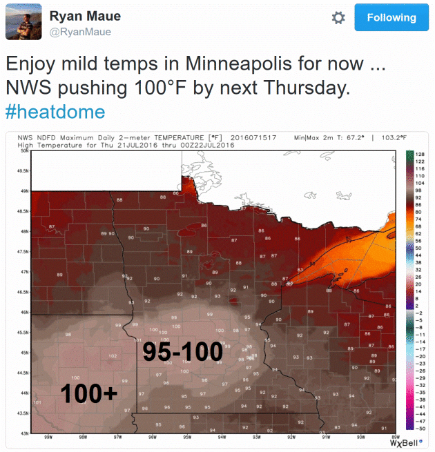
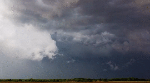
Record Rains - Risky Heat Spike Late Next Week
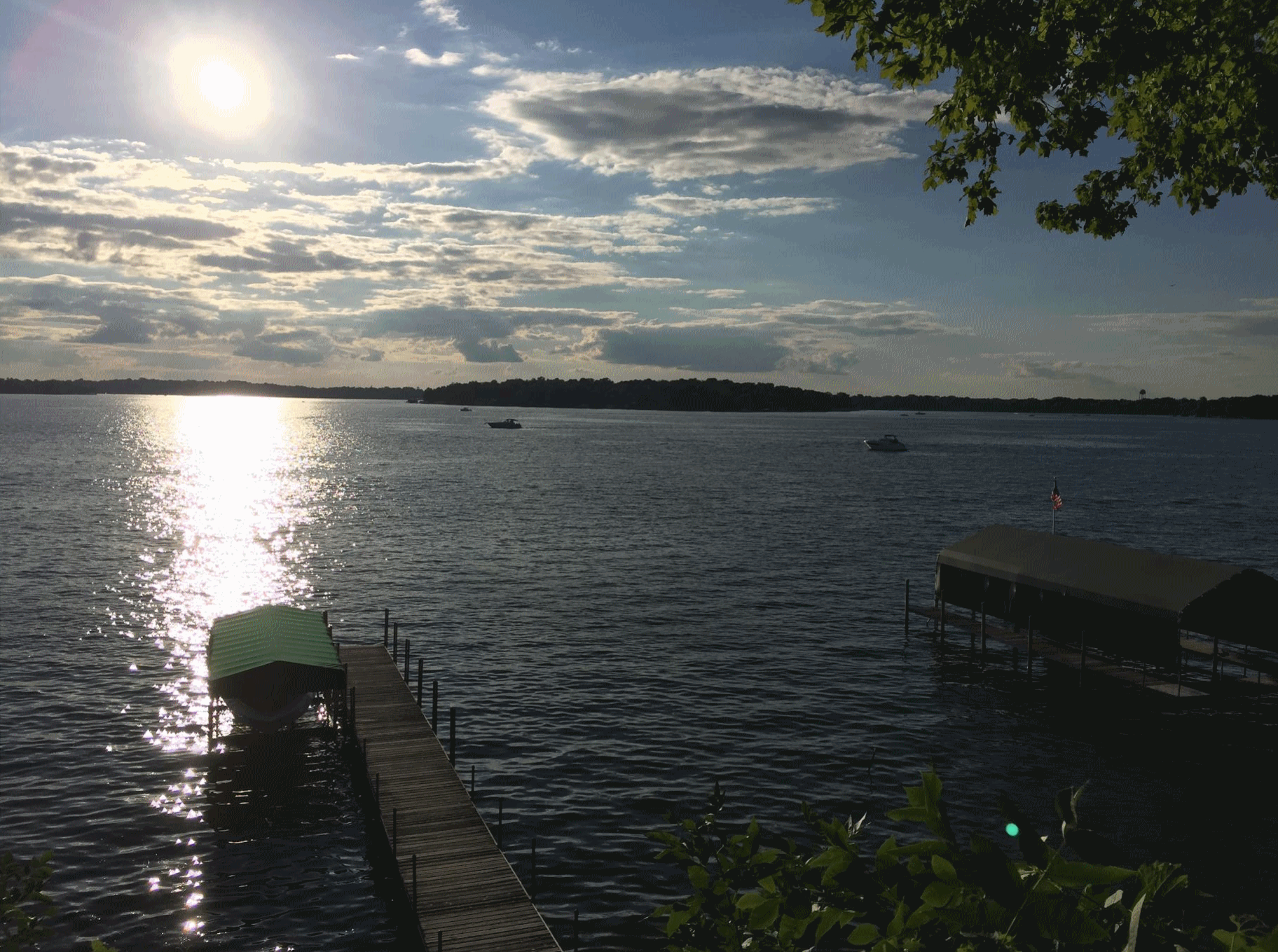
So who cares about a couple degrees of warming? Maybe the guy up in Brainerd who reported nearly 9 inches of rain in his rain gauge earlier this week. Warmer air holds more water vapor, more moisture to fuel intense summer rains.
Monday was another "mega-rain" event, classified as 6 inches of rain falling on at least 1,000 square miles. According to Mark Seeley there have been 13 such Minnesota floods since the early 1800s. Six of these have occurred since 2002.
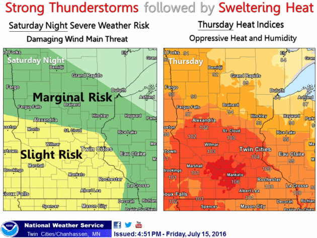
A warmer background temperature also increases the frequency and intensity of extreme heat events, similar to what it's in store next week. NOAA's local Twin Cities office said: "This set-up is even more favorable than some of the hottest heat waves in the past. Confidence continues to increase for a potentially dangerous heat wave."
The heat peaks next Thursday or Friday, when a few towns nearby may hit 100F. Factor in dew points in the 70s for a heat index close to 110F. A serious sauna - and very dangerous.
An MCS T-storm complex tonight packs torrential rains; 1-3 inches may soak a few towns. Welcome to the steaming jungles of Minnesota!


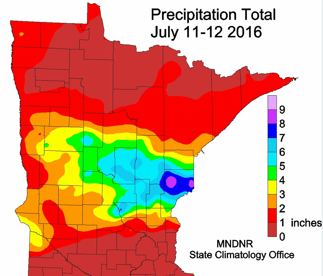
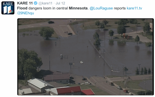
This Week's Northland Flood Biggest Since 2012. So says the Minnesota DNR and State Climatology Office; here's an excerpt: "The largest flash flood since the June 19-20, 2012 event in northeast Minnesota struck some of the same areas on July 11-12, 2016. This time Pine County was hit especially hard. The highest two-day total found so far with this event was 9.34 inches at a DNR rain gauge volunteer site near Cloverton in eastern Pine County, near the Wisconsin border. The event was approximately 24 hours in duration, but spanned over the observer's observation time. Flooding rains also affected parts of Morrison, Aitkin, Cass, Crow Wing, Benton, Mille Lacs, Kanabec and Carlton Counties. Numerous roads were affected by water in the hardest hit counties. Southbound I-35 was closed for a time and Highway 61 was closed during the afternoon hours of the 12th. The area covered by six inches or more of rainfall exceeded 2,000 square miles, with at least 1,000 square miles in Pine County alone...."


CDC found that over 650 people die per year from exposure to extreme heat (most of any weather threat). These deaths are preventable. Heat is considered a silent killer. It doesn’t come in toppling down trees or damaging homes, and often people don’t even know that they are suffering from heat illness.Dr. Hawkins is spot on. I cringe when I hear a death from heat and football called an “accident...”
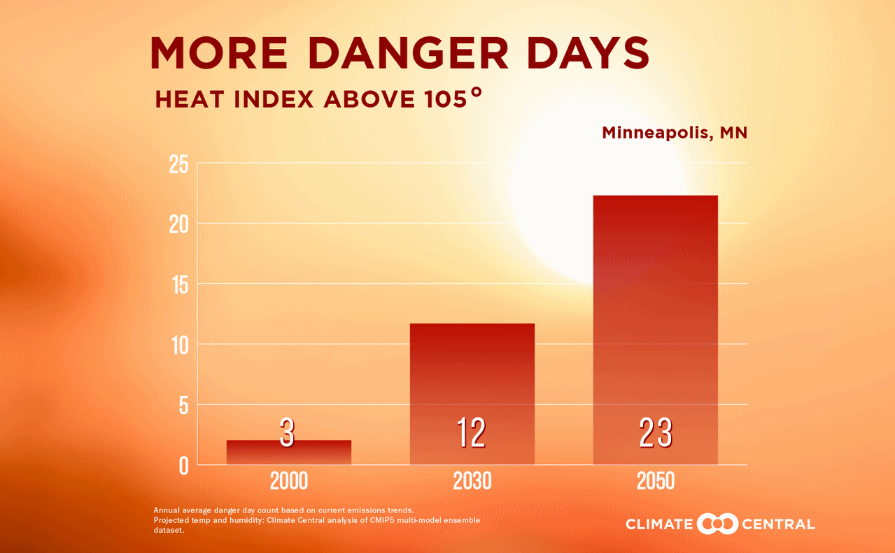
Twin Cities Heat Index and Dew Point History. It is quite possible that heat late next week will rival the heat observed in 1936, so this post is highly relevant. The Minnesota DNR takes a look at 100-degree heat and the history of dew point and heat index observations; here's the intro: "...Hitting
100 degrees is not a common occurrence for the Twin Cities metro area
and happens in about one in five years. The most recent 100 degree
reading occurred on July 4th and 6th of 2012. The hottest temperatures
in the Twin Cities occurred in July 1936, during the Dust Bowl era. An
all-time record of 108 degrees was observed on July 14, 1936. A high of
106 was recorded for each day from July 10th through the 12th in July
1936. In total an impressive 8 days in July 1936 were above 100 degrees,
with another day in August also above 100. This put the summer of 1936
at 9 days with temperatures at or above the century mark. This is a
record amount for the Twin Cities..."
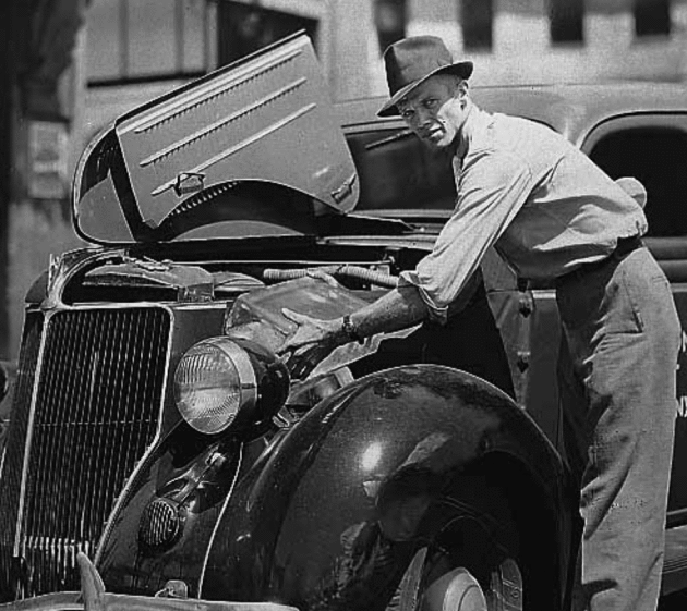
Photo credit: "Cooling a Car in the 1930's." Courtesy: Minnesota Historical Society.
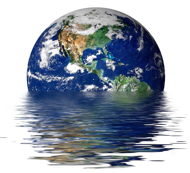
U.S. Faces Dramatic Rise in Extreme Heat, Humidity. Climate Central has some timely perspective: "...Heat is the No.1 weather related killer, and as carbon pollution continues, global temperatures will keep climbing, bringing hotter summers and more extreme and dangerous heat. Climate Central's States at Risk project analyzed historic trends in summer temperatures since 1970 as well as projections for future extreme heat for hundreds of metro areas across the lower 48 states. Using several measures, our findings show that most U.S. cities have already experienced large increases in extreme summer heat and absolute humidity, which together can cause serious heat-related health problems..."
Tornado Warning Forces 3 World Leaders Into School Basement. You may think you're hot stuff, until Mother Nature puts you in your place. The Star Tribune explains: "Three
former world leaders were forced to take shelter in the lower level of
an Arkansas high school after tornado sirens blared during a graduation
ceremony for the Presidential Leadership Scholars Program. Former
Presidents George W. Bush and Bill Clinton and former Britain Prime
Minister Tony Blair were attending the ceremony at Little Rock's Central
High School when the storm struck Thursday night. The attendees were
moved to the lower level of the high school, and a spokesman for Clinton
says the three leaders also took shelter downstairs, away from the
crowd..."
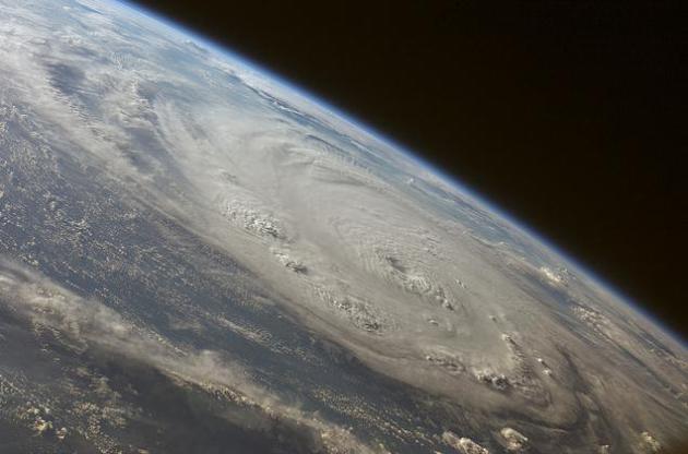
Where Are The Hurricanes?
No shortage of record typhoons in the western Pacific, but it's been
supernaturally quiet in the Atlantic for over a decade, in spite of
warming water. Here's a clip from a New York Times story: "The
United States coastline has been calm so far this hurricane season,
just as it has been over the last decade. Since 2005, the year of Hurricanes Katrina, Rita and Wilma, the country has been in a hurricane “drought,” with no major hurricane (Category 3 or above, meaning winds above 110 miles per hour)
making landfall. The nation’s most hurricane-prone regions, the
Southeast and Gulf Coasts, have been eerily quiet. Even so, climate
scientists like me believe that human-induced climate change
will strengthen hurricanes and lead to worse disasters. We know that
significant global warming, over a degree and a half Fahrenheit, has
already occurred since preindustrial days. So where, you might ask, are
the powerful hurricanes?..." (2007 Hurricane Felix file image: NASA).
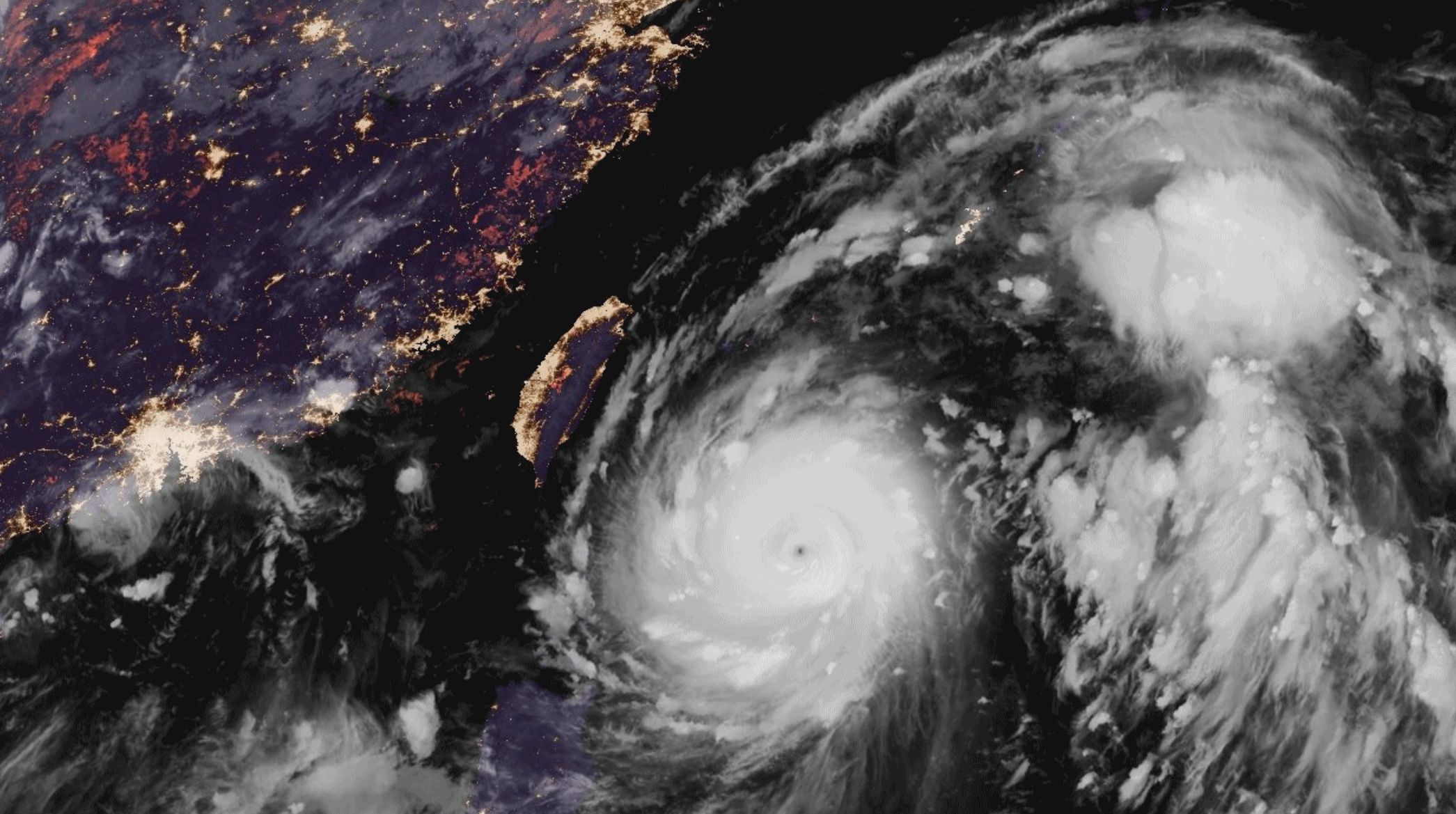
In Warming Oceans, Stronger Currents Releasing Heat in Bigger Storms, Study Says. InsideClimate News has a summary of recent research; here's an excerpt: "Global
warming is intensifying some of the world's most important ocean
currents, new research shows, raising the risk of damaging storms along
heavily populated coastlines of China and Japan. The findings are
sobering as China and Taiwan rebound from the devastating effects of
super typhoon Nepartak last week.
The western boundary currents, which run along the eastern coasts of
South Africa, Asia, Australasia, and South America, carry massive
amounts of heat from the tropics northward. The recent research by a group of scientists with the Alfred Wegener Institute Helmholtz Centre for Polar and Marine Research in Germany found they are strengthening, warming and moving poleward..."
Storm Chaser's Time-Lapse Video Is As Gorgeous As It Is Terrifying. I agree. Thanks to Mike Olbinski and Treehugger for passing this along: "Storms
chasers are a special breed of people. Upon a storm warning the natural
reaction for most of us might be, "ACK, take cover." Not for storms
chasers, it's more like, "Let's go get that thing!" Which seems to be
the exact attitude held by storm chaser (and wedding photographer!) Mike Olbinski who set out to capture some storms, and man did he ever..."
Video clip credit: Mike Olbinski/Vimeo
Why You Should Fear an "Ecological Recession". Because nature always bats last. Here's a snippet from TIME: "More than half of the world may be experiencing a dangerous loss in biodiversity. Human efforts to slow biodiversity loss are falling short across the globe, which could in turn harm future human development and wellbeing, according to new research. Researchers behind study, published in the journal Science, found that human-caused pressures like land use change—the
destruction of natural habitats often for timber, agriculture or
residential developments—have cause biodiversity to fall to
unsustainable levels more than half of the world’s surface..."

Here's How The World Could End - And What We Can Do About It. Science has a quick read that will make it a bit harder to fall asleep; here's an excerpt: "...Some researchers fear that another Carrington-like event could destroy tens to hundreds of transformers, plunging vast portions of entire continents into the dark for weeks or months—perhaps even years, Murtagh says. That’s because the custom-built, house-sized replacement transformers can’t be bought off the shelf. Transformer manufacturers maintain that such fears are overblown and that most equipment would survive. But Thomas Overbye, an electrical engineer at the University of Illinois, Urbana-Champaign, says nobody knows for sure. “We don’t have a lot of data associated with large storms because they are very rare,” he says. What’s clear is that widespread blackouts could be catastrophic, especially in countries that depend on highly developed electrical grids. “We’ve done a marvelous job creating a great vulnerability to this threat,” Murtagh says. Information technologies, fuel pipelines, water pumps, ATMs, everything with a plug would be rendered useless. “That’s going to affect our ability to govern the country,” Murtagh says..."
Photo credit: "Electrical surges due to a solar storm shocked telegraph operators in 1859; today, they could wreak havoc on power grids and electronics." NASA/Martin Stojanovski.

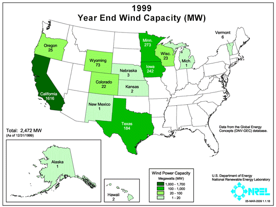
Map credit: "The year-by-year growth in wind capacity, by state." CREDIT: Department of Energy.

The Future of Breaking News? We'll
still need cable news to help with analysis and perspective (or will
we?) but the past few nights I've glimpsed the future of live, global
news coverage with Periscope and Facebook Live. Extremely powerful
technology - with any luck shining a light on events with our
smartphones may illicit better behavior, knowing people are watching.
Wishful thinking?

Why Did American Cats Get Blamed For So Many Divorces? I had no idea, but here comes Atlas Obscura to make sense of the senseless: "...The
relative newness of cats as pets was a fulcrum for these early divorce
cases. Household pets were not assumed the respect they might be given
today, which put couples at odds when one of them was more partial to
cats. Another 1912 divorce report from the The Los Angeles Herald,
a veritable record of cat and divorce news, concerned a 74-year-old
Civil War veteran who could not handle his wife’s 35 cats and two dogs,
in part because she “gave them more care than she gave him.” He seemed
traumatized: "In all my experience of four years as a soldier,” he said,
“I never had to contend with such conditions as those dogs and cats
created in our home....”
Image credit: "Too many cats has also been cited as a reason for divorce, although in that case there were certainly more than two." (Photo: Internet Archive/Public Domain).

Dog Days Coming. These guys won't even notice the heat next week. Where do I sign up? A very funny video clip courtesy of Barkhaus on Facebook. Yeah, I have those same sunglasses but they look better on him.
TODAY: Intervals of sunshine, a few degrees warmer. Winds: S 10-15. High: 81
TONIGHT: Strong T-storms possible, a few may be severe. Low: 66
SUNDAY: Unsettled, humid. More T-storms around. Winds: SW 8-13. High: 85
MONDAY: Partly sunny, almost comfortable. Winds: NW 5-10. Wake-up: 65. High: 82
TUESDAY: Sticky sunshine returns. Wake-up: Winds: S 8-13. 67. High: 86
WEDNESDAY: Early thunder, then hot sun. Winds: S 10-15. Wake-up: 70. High: 90
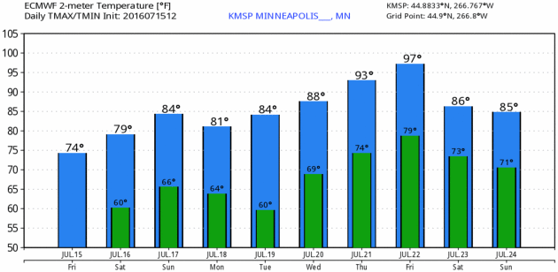
THURSDAY: Broiling sun, feels like 105 to 110F. Wake-up: 74. High: 98
FRIDAY: Scottsdale with lakes! Hot sun. Winds: NE 5-10. Wake-up: 80. High: 96
SUNDAY: Unsettled, humid. More T-storms around. Winds: SW 8-13. High: 85
MONDAY: Partly sunny, almost comfortable. Winds: NW 5-10. Wake-up: 65. High: 82
TUESDAY: Sticky sunshine returns. Wake-up: Winds: S 8-13. 67. High: 86
WEDNESDAY: Early thunder, then hot sun. Winds: S 10-15. Wake-up: 70. High: 90
THURSDAY: Broiling sun, feels like 105 to 110F. Wake-up: 74. High: 98
FRIDAY: Scottsdale with lakes! Hot sun. Winds: NE 5-10. Wake-up: 80. High: 96
* Long-range models hint at slight relief the weekend of July 23-24.
Climate Stories...
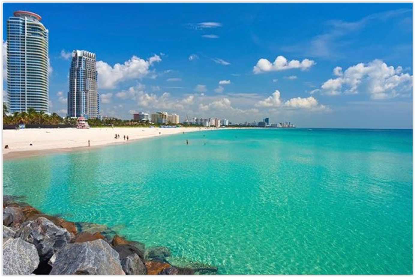
At Ground Zero for Rising Seas, TV Meteorologist Talks Climate. I have a lot of respect for John Morales in Miami, talking on the air about the ways a warming climate is already flavoring weather across south Florida. Here's an excerpt of an interview at Yale Environment 360: "...Ten years ago we had a big problem among broadcast meteorologists, who by greater than 50 percent seemed to be in the skeptic camp of anthropogenic global warming, according to some surveys. They either weren't communicating it, or they were finding ways to disparage the state of the science. Recognizing this, Bob Ryan, a former president of the American Meteorological Society (AMS), and myself, we co-authored an article in 2007 in the Bulletin of the American Meteorological Society saying that our profession is the face of science for the general public, that it is our responsibility to communicate the state of the science of climate change, that, in doing so, we need to divorce ourselves from political, religious, personal, and other views and just simply communicate the state of the science at the time..." (File image of Miami Beach: Trip Advisor).

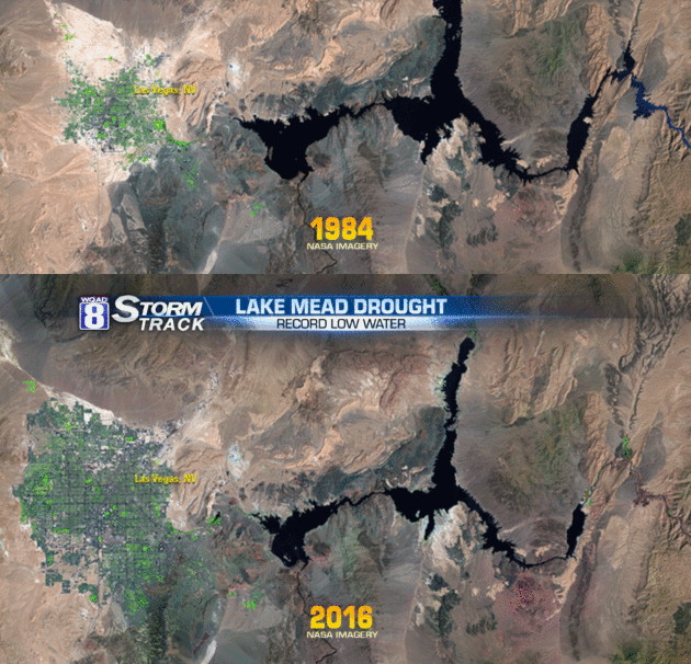
Scientists Think They've Just Pinpointed the Key Driver of Ice Loss in Antarctica. Chelsea Harvey reports at The Washington Post: "The Antarctic Peninsula is headed for trouble — that much scientists know. Glaciers on the peninsula, which extends from the increasingly unstable West Antarctic region, have been retreating for decades, and some in the region have undergone particularly accelerated melting since the 1990s. Until recently, many scientists assumed that a steady increase in air temperature around the peninsula, the product of global warming, was the primary cause behind most of the ice loss. But new research looking at the western side of the peninsula suggests that this may not be the case after all. A study published Thursday in the journal Science suggests that warm ocean water may be the biggest driver of glacial retreat in that region — and it’s a problem that may not be getting enough attention..."
Photo credit: "An edge of the Thwaites Ice Shelf in Antarctica." ( Jim Yungel/NASA).
Here Is What a Conservative Climate-Action Agenda Would Look Like. A carbon tax (let's call it a fee), eliminating all subsidies across the board, a market-friendly approach that reduces the need for government intervention over time? Here's an excerpt from Grist: "...The tax code is riddled with provisions that promote inefficiency and favor politically connected industries. Leading Republicans including House Speaker Paul Ryan and every presidential candidate in the last few cycles have argued for cleaning up and simplifying the tax code. One great way to do so would be to eliminate the various tax breaks for fossil fuel producers, particularly for oil and gas, which currently cost taxpayers several billion dollars per year. Republican politicians, of course, often favor these gifts because fossil fuels are popular among their base and are dominant in the economies of many red states. But principled conservatives should favor getting rid of them. (And if they want to make sure the government isn’t left favoring wind and solar, they could schedule fossil-fuel and clean-energy tax credits to phase out simultaneously.)..."
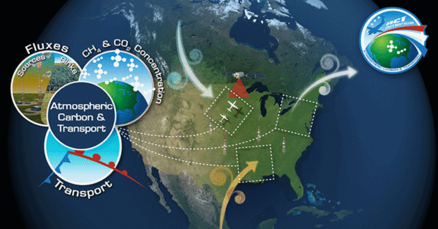
Graphic credit: "ACT-America, or Atmospheric Carbon and Transport – America, will conduct five airborne campaigns across three regions in the eastern United States to study the transport and fluxes of atmospheric carbon dioxide and methane."

Image credit: "This July 13 image captured by a device on NASA’s Aqua satellite shows Franz Josef Land in the Arctic Ocean." (AFP/NASA)

State Attorneys General Subpoenaed by Rep. Lamar Smith for Exxon Fraud Probe. Here's the latest from InsideClimate News: "Rep.
Lamar Smith, chairman of the House Science Committee, escalated his
confrontation over the climate probes of ExxonMobil by issuing subpoenas
to two state attorneys general and several nongovernmental advocacy
groups on Wednesday. Smith (R-Tex.) announced the
action in a news conference on Capitol Hill, saying the attorneys
general of New York and Massachusetts were trying to criminalize the
opinions of people and companies who hold alternative views on climate
science..."
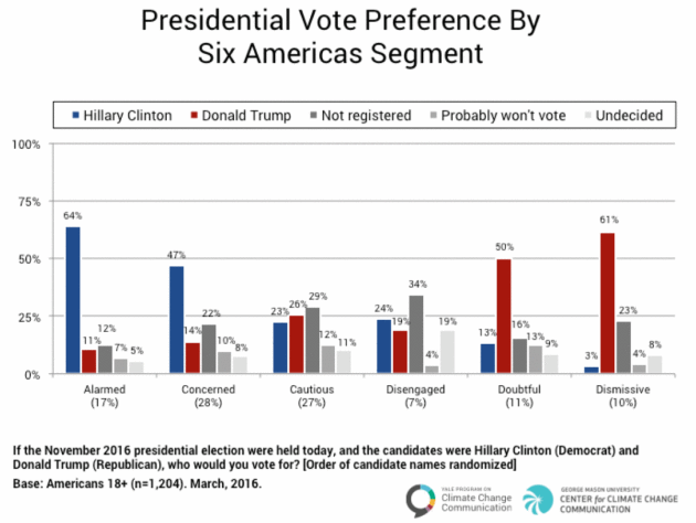
What Type of Climate Voter Are You? Here's a clip from Fusion: "A
new analysis has found that 10% of the population of voters are more
likely to vote for a candidate who opposes action on global warming.
Conducted by Yale University and George Mason University, the survey
found that Americans can be divided into six distinct groups when it
comes to climate and environmental voting preferences. Only members of
the most anti-climate action group, the Dismissive (10% of the
population; 10% of registered voters), are likely to vote for a
presidential candidate who actually prioritizes their opposition to
taking action to curtail human-caused climate change..." (Graphic: Yale University and George Mason University).

The Climate Anxiety Doctor is "In". Here's a clip from an article at Hakai Magazine: "...In the psychological literature, there is an increasing body of research demonstrating the toll that climate change
can take. Climate change can affect mental health both as a result of
individual significant weather events, and as a result of more gradual
changes in climate. Psychologists have found that catastrophic events
induce different mental health issues than gradual changes: catastrophic
events are more likely to induce trauma responses, major depression,
and complicated grief, while gradual changes can cause anxiety,
fatalism, and chronic depression. A common thread running through all
these effects is fear of an increasingly uncertain future, and the
anxiety that fear generates is often not constructively addressed..."
No comments:
Post a Comment