83 F. average high on July 17.
85 F. high on July 17, 2015.
July 18, 2000: Fall apparel makes an early debut with a 60 degree high temperature at the Twin Cities, 54 at Brainerd and 52 at Cambridge.
July 18, 1970: A tornado slices right through the center of Miltona.
July 18, 1867: The greatest 'unofficial' rainstorm in Minnesota history is reported. 36 inches of rain is recorded in 36 hours near Sauk Center. Disastrous flooding occurs in central Minnesota. The Pomme De Terre river becomes impassable; a courier attempted to cross on horseback and drowned. Flooding also occurs on the Mississippi, with millions of logs lost on the river.

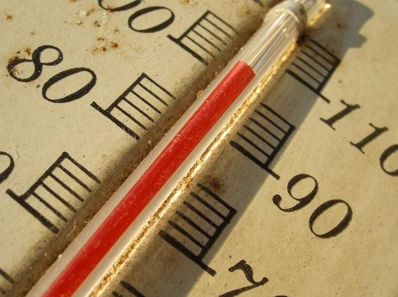
Hot Flash: Heat Warnings Likely Later This Week
"If you can’t fly then run, if you can’t run then walk, if you can’t walk then crawl, but whatever you do you have to keep moving forward" preached Martin Luther King Jr.
We live in a fantastical age of running water, ice cream, air conditioning and swimming pool memberships. I wonder what the pioneers who settled Minnesota in the 1830s would make of all the creature comforts that insulate us from Mother Nature on a daily basis? They had little or no warning of heat waves, floods or tornadoes.
Did they complain - or take it one day at a time - with grim determination?
A heat wave is defined as "a prolonged period of abnormally hot weather". The next 2 weeks may fit that (squishy) definition. 90s are likely Wednesday into Friday; models hinting at 100-degree heat over central and western Minnesota. Factor a dew point in the 70s and it may feel like 105F later this week. Models cool us off slightly next weekend before another surge of sweaty 90s arrive late next week.
100 degrees in the metro area? I wouldn't rule it out. The last time MSP hit 100F was July 6, 2012 (102F).
Time to dig out your inner-pioneer.
- Excessive Heat Warning—Take Action! An Excessive Heat Warning is issued within 12 hours of the onset of extremely dangerous heat conditions. The general rule of thumb for this Warning is when the maximum heat index temperature is expected to be 105° or higher for at least 2 days and night time air temperatures will not drop below 75°; however, these criteria vary across the country, especially for areas not used to extreme heat conditions. If you don't take precautions immediately when conditions are extreme, you may become seriously illness or even die.
- Excessive Heat Watches—Be Prepared!Heat watches are issued when conditions are favorable for an excessive heat event in the next 24 to 72 hours. A Watch is used when the risk of a heat wave has increased but its occurrence and timing is still uncertain.
- Heat Advisory—Take Action! A Heat Advisory is issued within 12 hours of the onset of extremely dangerous heat conditions. The general rule of thumb for this Advisory is when the maximum heat index temperature is expected to be 100° or higher for at least 2 days, and night time air temperatures will not drop below 75°; however, these criteria vary across the country, especially for areas that are not used to dangerous heat conditions. Take precautions to avoid heat illness. If you don't take precautions, you may become seriously illness or even die.
- Excessive Heat Outlooks are issued when the potential exists for an excessive heat event in the next 3-7 days. An Outlook provides information to those who need considerable lead-time to prepare for the event.
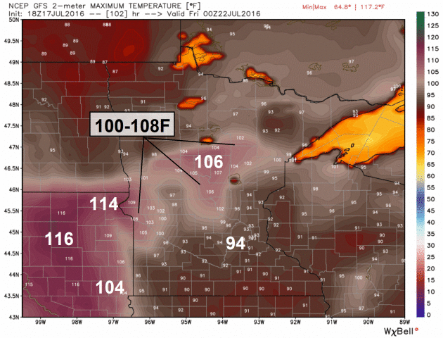
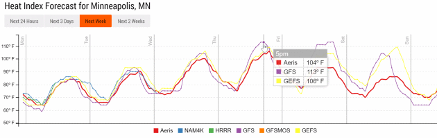
Thursday Highs Above 100F?
GFS guidance is predicting maximum temperatures as high as 106F from
near Wheaton to Wadena and Brainerd on Thursday, with a heat index as
high as 110 to 115F. It does appear the best chance of 100-degree surface
temperatures will be over western and central Minnesota later this
week. Map: WeatherBell.
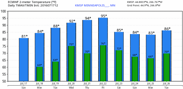
European Numbers.
ECMWF guidance predicts mid-90s Thursday and Friday with a heat index
well above 100F in the Twin Cities; slight relief returning next weekend
with mid-80s. You know it's stinking hot when 80s represents "relief".
Graphic: WeatherBell.
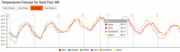
Hottest Days: Wednesday into Friday.
Our internal model ensemble shows fairly tight alignment among the
various solutions; mid-90s likely Thursday, possibly Friday before a
slight cooling trend next weekend. But air temperature tells only half
the story. Meteogram: Aeris Enterprise.

Corn and Climate: A Sweaty Topic. More on corn, evapotranspiration, rising dew points and the siting of weather instruments in a 2011 post at UCAR: "...Stephen Corfidi, a forecaster with the NOAA Storm Prediction Center, has been keeping an eye on Midwestern moisture trends for decades. “Subjectively, from analyzing surface data over my career, I would say with near certainty that surface dew points have increased in the upper-mid Mississippi and lower Ohio Valleys over the last 30 years,” Corfidi told me by e-mail. “In particular, it seems as though broad swaths (say, 300- to 50-mile–wide corridors) with surface dew points averaging in the mid 70s Fahrenheit are no longer uncommon.” NCAR’s Peggy LeMone was inspired by a chat with Corfidi to look further into the issue. As she explains in a 2007 blog post, corn is being grown in ever-more-dense fields, and this could be helping to boost dewpoints. However, the exact role of intensified cropping is difficult to isolate. Corn-based agriculture is shifting in a variety of ways, including the use of longer-season cultivars and earlier planting, as recently noted by scientists from NCAR and the University of Wisconsin–Madison..." (photo credit: Star Tribune).

* Check out the new and improved Springbrook Nature Center for yourself. This is where the July 18, 1986 tornado spent most of its time, ripping trees out of the park as if they were weeds. You can still see some evidence of the tornado, but park staff and volunteers have done a wonderful job creating a remarkable urban park unlike any other in the Twin Cities metro.

Photo credit: "A sign reads, "WATKINS TOUGH" is proudly propped outside of a residence on Sunday, July 17 in Watkins." (Photo: Jessie Wade, jwade@stcloudtimes.com)
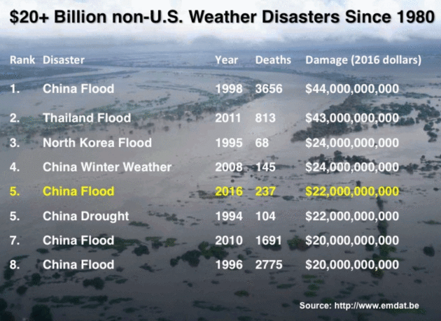
Image credit: "This summer's floods in China are the fifth most expensive weather-related natural disaster outside of the U.S. in recorded history, according to the International Disaster database, EM-DAT."


TODAY: Sunny & pleasant. Winds: NW 5-10. High: 84
MONDAY NIGHT: Partly cloudy and mild. Low: 67
TUESDAY: Sticky sunshine, bordering on hot. Winds: S 10-15. High: 89
WEDNESDAY: Isolated T-storm, feels like 100F+ Dew point: 75. Wake-up: 74. High: 92
THURSDAY: Heat Warning. Beastly hot, feels like 105-110F. Wake-up: 77. High: 97
FRIDAY: Still sauna-like, nighttime T-storms. Feels like 100-105F. Winds: NE 5-10. Wake-up: 79. High: 95
SATURDAY: Early storms. Clearing, slight relief. Winds: NW 10-15. Wake-up: 73. High: 87
SUNDAY: Sunny and pleasant. Not as sweaty. Winds: NW 5-10. Wake-up: 68. High: 86
Climate Stories...

The World's Climate Pledges Are Not Even Close to Good Enough. Here's the intro to a story at Co.Exist: "In a little over a decade, if every country around the world keeps every current promise to cut carbon emissions, it's likely the planet will warm up 1.5 degrees Celsius. By 2100, the world's average temperature may have gone up as much as 3.1 degrees—with a risk of hitting 4 degrees, well into the range for global catastrophe. A recent study looked at the pledges made at the Paris climate talks in 2015, where countries agreed to keep warming below 2 degrees Celsius—and ideally below 1.5 degrees. The goal is what most scientists think is necessary to avoid the worst impacts of climate change. The problem is that the pledges each country has made so far will completely miss the target..."
Video: Las Vegas office of The National Weather Service.

Here Is What a Conservative Climate-Action Agenda Would Look Like. A carbon tax (let's call it a fee), eliminating all subsidies across the board, a market-friendly approach that reduces the need for government intervention over time? Here's an excerpt from Grist: "...The tax code is riddled with provisions that promote inefficiency and favor politically connected industries. Leading Republicans including House Speaker Paul Ryan and every presidential candidate in the last few cycles have argued for cleaning up and simplifying the tax code. One great way to do so would be to eliminate the various tax breaks for fossil fuel producers, particularly for oil and gas, which currently cost taxpayers several billion dollars per year. Republican politicians, of course, often favor these gifts because fossil fuels are popular among their base and are dominant in the economies of many red states. But principled conservatives should favor getting rid of them. (And if they want to make sure the government isn’t left favoring wind and solar, they could schedule fossil-fuel and clean-energy tax credits to phase out simultaneously.)..."

No comments:
Post a Comment