Meteorological Jackpot - Best Weekend of Summer 2016?
By Todd Nelson, filing in for Douglas
Wow, what a weekend! Not sure I've seen weather maps so nice, so perfect since the 4th of July weekend. Summer can always be a gamble. It's either too hot or too muggy or too something, but not this weekend. In fact, it might be too perfect. Enjoy it, summer is slipping away fast!
Get this, we've lost nearly 1 hour of daylight since the Summer Solstice back on June 20th. The average high temperature in Minneapolis has dropped 2 degrees from its peak of 84 degrees in mid July. The average high actually drops to the upper 70s by the end of the month. Don't get me wrong, we still have lots of summer weather to come, but we're a little more than 2 weeks away from the start of the MN State Fair! My mouth is already starting to water; I better start dieting now.
Bright sun, low humidity and a mild breeze will make this summer weekend one of the best of 2016. Let me know if you figure out how we can bottle this up and open 4 to 5 months from now when we're talking wind chill. Sticky weather returns this week with a chance of thundery downpours.
_________________________________
_________________________________
Extended Forecast
FRIDAY NIGHT: Clear and pleasant. Winds: NW 0-5. Low: 60
SATURDAY: Bright sun and beautiful. Winds: NNW 5-10. High: 80. Dewpoint: 57.
SATURDAY NIGHT: Mostly clear, quiet and comfortable. Winds: NW 0-5. Low: 61.
SUNDAY: More sun, still gorgeous. Winds: SSE 5. High: 82. Dewpoint: 58.
MONDAY: More humid, spotty thunder overnight. Winds: SSE 7-12. Wake-up: 62. High: 83. Dewpoint: 62
TUESDAY: Summer muggies return. Spotty PM T-shower. Winds: SSW 5-10. Wake-up: 68. High: 87. Dewpoint: 70.
WEDNESDAY: Sticky sun, afternoon storms possible. Winds: ESE 7-12. Wake-up: 70. High: 87. Dewpoint: 70.
THURSDAY: Scattered storms, some with heavy rain. Winds: SSE 5-10. Wake-up: 70. High: 84. Dewpoint: 66.
FRIDAY: Unsettled. Still warm and somewhat humid. Winds: E 7-12. Wake-up: 69. High: 85. Dewpoint: 66.
_____________________________________
_____________________________________
This Day in Weather History
August 6th
August 6th
1969: Tornadoes sweep across northern Minnesota, hitting Ely, Backus, Outing and Dark Lake. Damage could still be seen 20 years later in the BWCA.
1866: Torrential rain dumps 10.30 inches at Sibley in 24 hours. Widespread flooding occurs, washing out bridges and drowning many people. In Fillmore County it is known as the 'Wisel Flood' because 3 members of the Wisel family perished in the flood.
_________________________________
_________________________________
Average High/Low for Minneapolis
August 6th
August 6th
Average High: 82F (Record: 99F set in 2001)
Average Low: 63F (Record: 48F set in 1977)
__________________________________
Average Low: 63F (Record: 48F set in 1977)
__________________________________
Sunrise/Sunset Times for Minneapolis
August 6th
August 6th
Sunrise: 6:05am
Sunset: 8:32pm
Sunset: 8:32pm
Daylight lost since yesterday: ~2mins & 33secs
Daylight lost since Summer Solstice: ~1hour
___________________________________
Daylight lost since Summer Solstice: ~1hour
___________________________________
Moon Phase for August 6th at Midnight
3.5 Days Before First Quarter
3.5 Days Before First Quarter

____________________________________
Temperature Outlook for Minneapolis
It'll be a brilliant weekend across much of the Upper Midwest with bright sunshine, low humidity and a mild breeze. Temperatures will be at or slightly below averae through the early week timeframe, but not the heat bubbling back as we head into the middle part of next week. Some spots could see readings back in the 90s with dewpoints in the 70s.
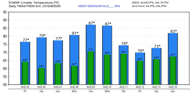
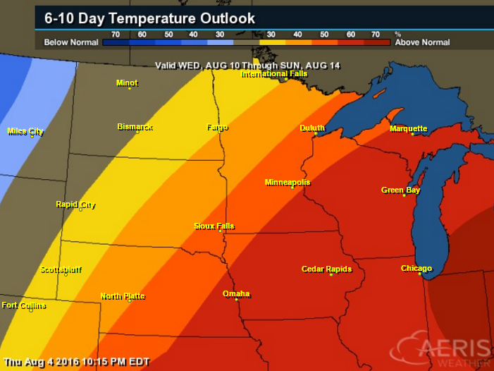
6 to 10 Day Temperature Outlook
Here's the 6 to 10 day temperature outlook from NOAA's CPC, which suggests a fairly decent chance of warmer than average temperatures from August 10th - 14th. The 8 to 14 day temperature outlook suggests that we'll be a little closer to average, which will take us through mid August.
_____________________________________________
Saturday Weather Outlook
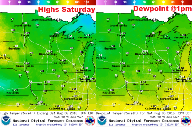
Looking at the high temperature and dewpoing map for Saturday, it looks like a winner! Temperatures will be running at or slightly below average, while dewpoints will be quite comfortable in the mid/upper 50s. No worries!
Saturday Weather Outlook
As a bubble of high pressure drifts over the Upper Midwest this weekend, winds will be fairly light. Winds will generally be out of the north on Saturday, which will help to continue our more comfortable temps and humidity values on Saturday.
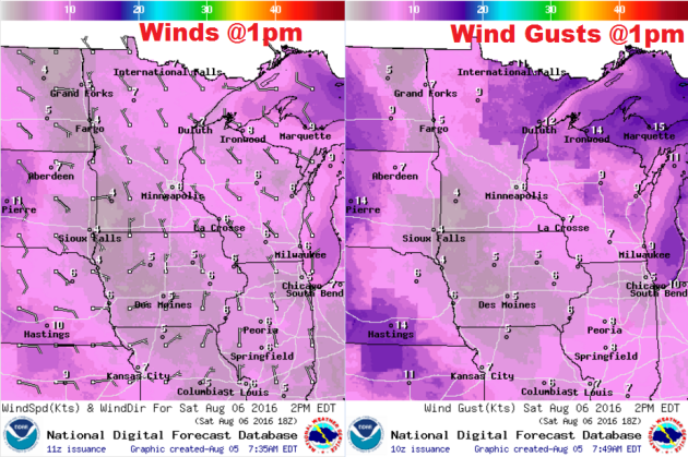
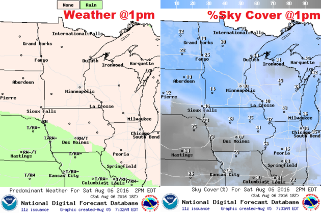
Saturday Weather Outlook
No problem with the map below either. Lots of sun and no threat of any rain. You'll more more than ok planning any outdoor activities Saturday or Sunday.
Weather Outlook
Here's the weather outlook through early next week, which doesn't suggests any moisture making its way into the region. Our next best chance of any spotty shower or thunderstorm activity won't arrive until late Monday or Tuesday. The best chances of rain will arrive mid/late week next week. Stay tuned.
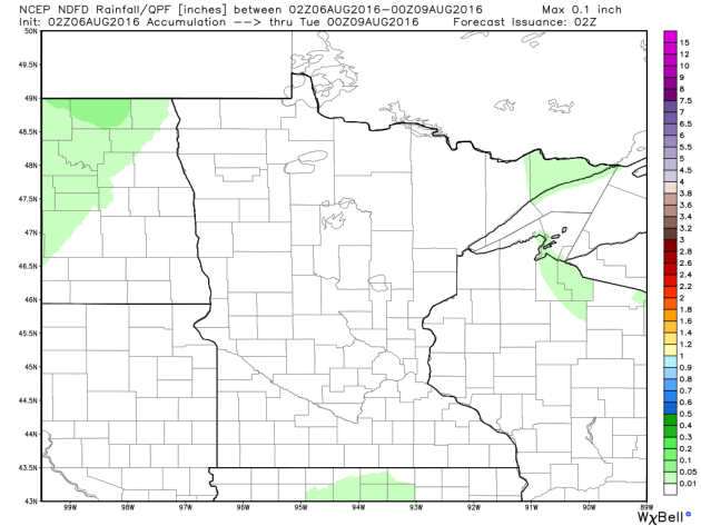
Rainfall Potential
Here's the rainfall potential through the weekend. Nothing, nada, zilch...
_______________________________
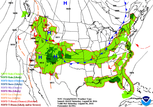
National Weather Outlook
The national weather outlook below shows the cold that pushed through the Upper Midwest on Thursday, continuing to push through the Eastern U.S. through the weekend. In its wake, cooler less humid air. Most of the rain and thunder potential this weekend will be found from the Southwest to the Southeast. Some areas there could see heavy rain and flooding.
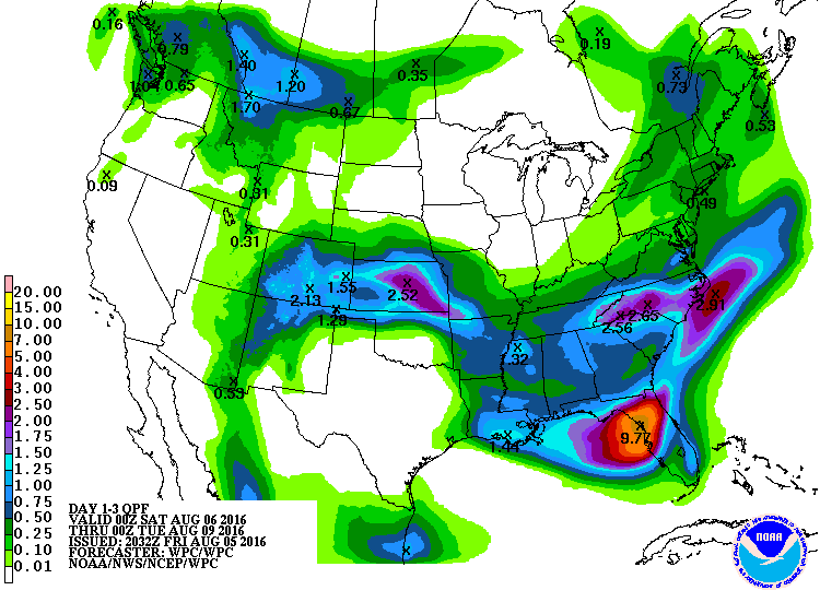
3 Day Precipitation Outlook
According to NOAA's WPC, the rainfall potential through the weekend suggests heavier rainfall across the Southwest through the Central U.S. and back into the Southeast. Some areas in the Southwest and into Florida could see the best potential of flooding this weekend. Note the significant rainfall across parts of central and northern Florida, where up to 3" to 6"+ can't be ruled out!
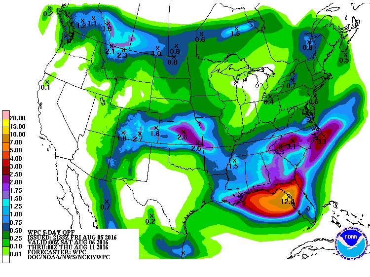
5 Day Precipitation Outlook
Looking at the 5 Day, note how widespread the heavy rainfall appears to be from the Gulf Coast to the Outer Banks of North Carolina. Areas within this area could see signifant rainfall and flooding concerns through the early part of next week.
____________________________________
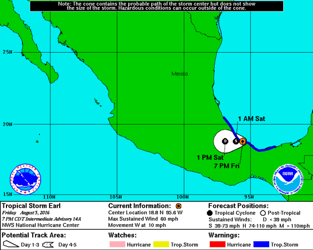
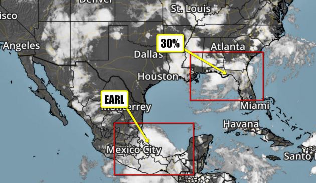
Tropical Update
Here's a look at Tropical Storm Earl from Thursday and it continued to bring heavy rainfall to parts of southern Mexico. Earl made landfall as a hurricane late Wednesday night/early Thursday morning in Belize bofore quickly dimishing over land.
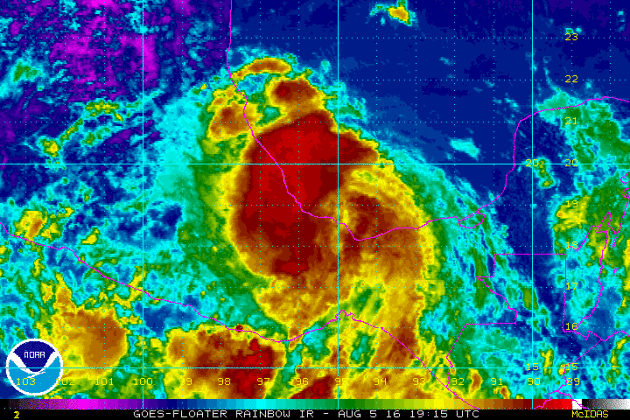
Earl will continue track slowly inland over southern Mexico before raining itself out at some point this weekend. With that said, heavy rainfall is expected with some flood concerns there.
According to NOAA's NHC, there is a 20% chance of tropical development in the northeastern part of the Gulf of Mexico. Although this particular wave has a low chance of development, heavy rainfall and flooding may be possible over the next several days from the Gulf Coast through northern Florida and into the Mid-Atlantic States.
__________________________________________
"Record-breaking year shows Earth’s climate is in real trouble"
"Dozens of climate records were broken last year, according to a report nicknamed the annual physical for the planet. Soon after 2015 ended, it was proclaimed the hottest on record – and the new report shows the broad extent of other records and near-records set last year. Those include record heat energy absorbed by the oceans and the lowest groundwater storage levels globally, according to the research from the National Oceanic and Atmospheric Administration (NOAA) in the US. “I think the time to call the doctor was years ago,” said NOAA climate monitoring chief Deke Arndt, co-editor of the report. “We are awash in multiple symptoms.” The 2015 State Of The Climate report examined 50 different aspects of climate, including dramatic melting of Arctic sea ice and glaciers worldwide."
 ____________________________________________________
Thanks for checking in and have a great weekend! Don't forget to follow me on Twitter @TNelsonWX.

No comments:
Post a Comment