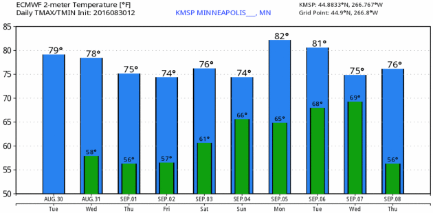
78 F. high temperature at KSTC Tuesday.
77 F. average high on August 30.
80 F. high on August 30, 2015.
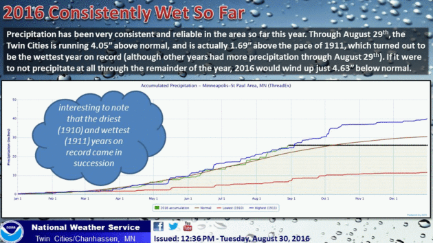
8.36" rain in St. Cloud in August. Normal rainfall is 3.66"
7.33" wetter than average since June 1.
 Comfortably Cool and Dry Weather Into Saturday
The
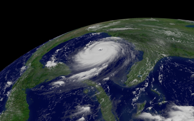
proliferation of Texas-size storms in the tropics got me thinking about
relative risk. As much grief as we get for our winters, when was the
last time you had to evacuate your home because of bad weather? Red
River flooding? Maybe. But snowstorms, even blizzards don't create the
kind of dislocation and dollar loss that a tropical storm or hurricane
does.
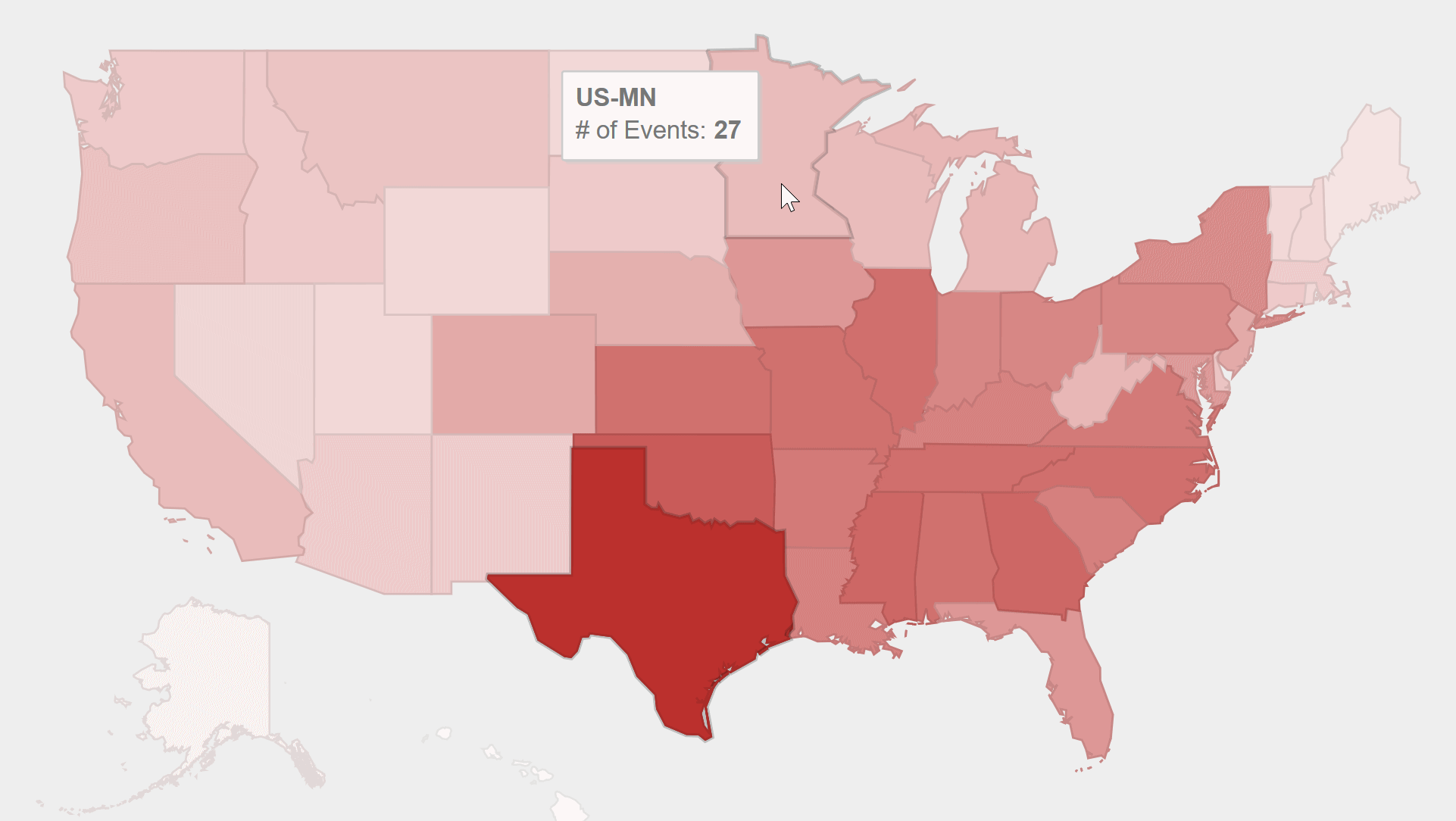
NOAA has analyzed all billion-dollar disasters in the U.S.
since 1980. Minnesota has experienced 26 such events, compared to 43 in
Florida and 83 in Texas - much higher numbers because both states are in
"Hurricane Alley". Safest state in the USA? Maine.
A tropical storm should hit Florida's Panhandle
Thursday before churning up the Carolina coast.
We salvage 4 more dry days in a row with a comfortable Canadian breeze and daytime highs mostly in the 70s.
Friday and
Saturday look like the sunniest, driest (nicest) days of the holiday weekend. T-storms prowl the state
Sunday and
Monday; have a Plan B ready to go, just in case.
And the truth? All those cold fronts inoculate Minnesota from the wildest storms on Earth.
Billion-dollar U.S. Weather Disasters: 1980-2016, courtesy of
NOAA NCDC.
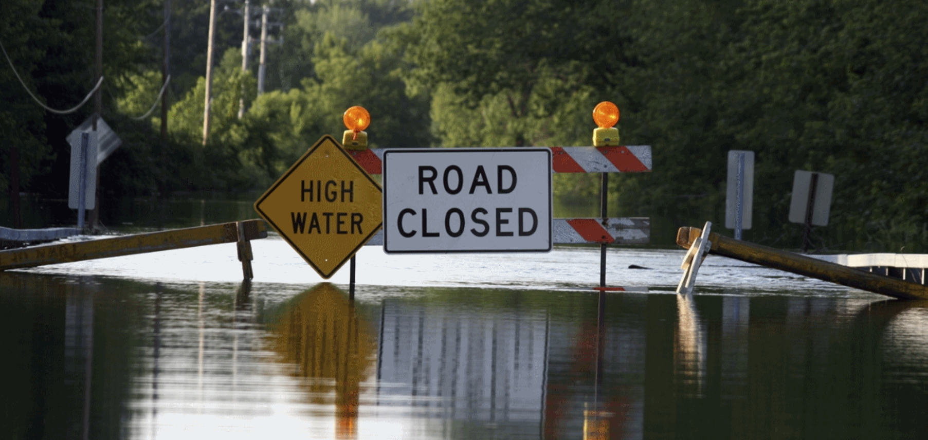
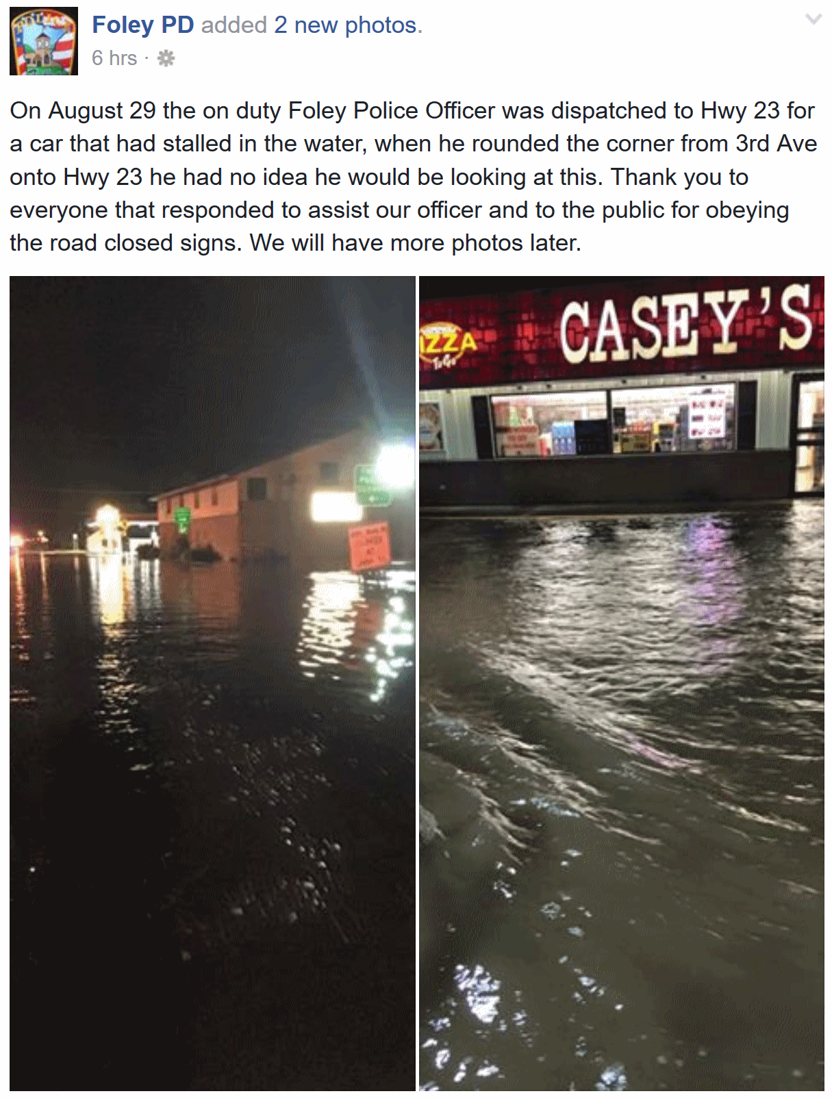 Monday Night Flash Flooding in Foley
. Check out the
Facebook post from the Foley Police Department - glad everyone is OK up there after crazy rains the other night!
Dry Into Saturday.
Cram your lake-time into Friday and Saturday, because showers and
T-storms return Sunday and Labor Day (of course). Models hint at
another 1-2" rain early next week. Just when you thought it couldn't get
any wetter. Model data: Aeris Enterprise.
Break From The Heat.
No more (stinking hot) weather looking out 2 weeks or so. We cool off
into late week before warming up a bit in time for Labor Day. Typical
weather for early September. Source: WeatherBell.
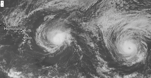
Two "Unprecedented" Hurricanes Are Churning Toward Hawaii.
Gizmodo has details: "
In
what’s being hailed a meteorological first, two back-to-back hurricanes
are marching toward Hawaii, both of them threatening torrential rains
and rip-roaring winds this week. The closer of the two, hurricane
Madeline, could break a second meteorological record as the first
hurricane to strike the Big Island since bookkeeping began in 1949.
Rumbling west at approximately 9 mph, Madeline is currently packing Category 3 windspeeds of 120 mph. Its latest track has the storm passing south of the Big Island on Thursday..."
Graphic credit: Aeris AMP.
Aeris Weather Briefings:
Issued Tuesday morning,
August 30, 2016
* Confidence levels grow (7 out of 10) that a strong tropical storm will reach Florida north of Tampa (Big Bend area)
Thursday with moderate impacts.
*
Greatest risk is inland flooding from 6-12" rains associated with this tropical system.
River and urban flooding is likely.
* 1 in 3 chance this system could strengthen into a weak Category 1 hurricane before landfall
on Thursday.
*
Sustained winds of 40-60 mph may create minor/moderate problems with
power outages in Ocala and Gainesville to Daytona Beach and
Jacksonville.
* Second system (Tropical Depression Eight) brushes
Outer Banks of North Carolina with 40 mph winds and heavy rains next 36
hours.
* Generally speaking -
we are heading into a busy tropical period.
NOAA's GFS model brings a hurricane close to the East Coast by the
second week of September. Conditions are ripe for more tropical close
encounters, even a few more direct hits over the next 2 weeks.
Brewing Tropical Storm.
The tropical depression (nine) in the Gulf of Mexico is packing 35 mph
sustained winds. When winds reach 39 mph we'll have Tropical Storm
Hermine, which should begin recurving toward the north and northeast
within 24 hours,
on a track which should take it into the Big Bend Region of Florida's
Gulf Coast. Map courtesy of Aeris AMP. Details via NOAA NHC:
HAZARDS AFFECTING LAND
----------------------
RAINFALL:  The depression is expected to produce additional rain
accumulations of 2 to 4 inches over western Cuba through Wednesday,
with maximum storm total amounts up to 12 inches.  These rains
could cause life-threatening flash floods and mud slides.  Storm
total rainfall amounts of 5 to 10 inches are possible over much of
the Florida peninsula through Friday morning, with isolated maximum
amounts of 15 inches possible.  This rainfall may cause flooding
and flash flooding.
Tropical Depression Eight.
Another system scheduled to intensify to tropical storm status (either
Hermine or Ian, depending on timing), Tropical Depression Eight is
producing 35 mph winds, already impacting the Outer Banks of North
Carolina with 20-40 mph winds and pounding surf. Minor flooding is
possible from Cape Hateras to Duck, Corolla and Virginia Beach close to
high tide. Map: NOAA NHC.
Official NOAA Track.
The system in the Gulf of Mexico is forecast to reach central and
northern Florida during the day Thursday as a moderate to strong
tropical storm, before accelerating out to sea over the weekend.
Strong Model Consensus.
The spaghetti plot of hurricane models has pretty well converged on a
coherent solution that brings the center of the tropical storm over
northern Florida
within 72 hours.
Map credit: Tropicaltidbits.com
Intensity Forecast.
A majority of models pull Hermine (or Ian?) into Florida as a healthy
tropical storm with sustained winds of 45-60 mph. There's at least a 1
in 3 chance that the storm will reach Category 1 hurricane status
before landfall
on Thursday.
Thursday Morning: HWRF Solution. NOAA's high-resolution hurricane model brings a ragged eye ashore over a lightly-populated region of Florida early
Thursday,
tropical storm force winds as far south as Tampa/St. Pete and even
Orlando. Tropical storm conditions move rapidly across Ocala and
Gainesville toward Tallahassee and Jacksonville. Map credit:
WeatherBell.
Thursday Morning: ECMWF Solution.
Meteorologists exhale (slightly) when models agree, and we now have
fairly strong agreement between NOAA and European models, showing
landfall well north of Tampa
on Thursday.
The biggest risk is inland flooding (river and urban) with rainfall amounts as high as 10-15".
Map credit: WSI.
Tropical Storm Impacts.
Our internal guidance shows a potential swath of minor to moderate
damage from Tampa and Orleando to Ocala, Gainesville, Daytona Bbeach and
Jacksonville, where I do anticipate sporadic power outages and
disruptions to transportation, especially Thursday.
Predicted Storm Surge.
With a strong counter-clockwise flow the highest storm surge will come
south/east of the storm's track, with greatest impacts north of
Clearwater, where a 6-8 foot surge can't be ruled out. A surge of 3-6
feet in the Tampa Bay area may create problems and lowland inundation,
especially close to high tide.
Biggest Risk: Inland Flooding.
With Gulf of Mexico water temperatures in the 85-90F range and
near-record amounts of water vapor available, extreme rainfall amounts
are expected across central and northern Florida, and then coastal
Georgia and the Carolinas with these 2 tropical systems. Flash flooding
is likely, even imminent. If you live in an area prone to flooding odds
are you'll experience more flooding over the next 72 hours.
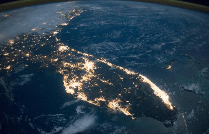
Best-Case Scenario.
The nighttime NASA satellite image tells the tale of population density
in Florida. With the exception of the Everglades, the Big Bend area of
northwest Florida is perhaps the most lightly-populated - no major
cities along the coast. This may reduce damage somewhat, but I don't
want to underestimate impacts from river and urban flooding associated
with this storm.
Summary: a tropical storm will reach northern and central Florida by
Thursday. Preparations should accelerate today; with conditions rapidly deteriorating late
Wednesday as the storm approaches. Another update
Wednesday morning.
Paul Douglas, Senior Meteorologist, AerisWeather
Why Long-Range Model Forecasts for the Tropics Can't Often Be Trusted: A Case Study. Good, timely perspective from
The Weather Channel; here's an excerpt: "...
While
numerical modeling and meteorology have advanced the past few decades,
any model forecast beyond 5-7 days should be taken with a large grain of
salt. This is particularly true in the tropics, where data to feed the
forecast model's initial guess of the current state of the atmosphere is
typically more sparse. Forecasts for tropical cyclones at any stage of
their lifetime extend out only to five days because the science hasn't
advanced enough to be greatly accurate beyond that time frame, although
we are getting there..."
Map credit above: GFS forecast, valid Sunday evening - courtesy of WSI.
7 Big Changes Since Katrina Made Landfall. Jason Meyers has some interesting nuggets at
WFTS-TV in Tampa: "...
More
storms, hurricanes and large hurricanes formed that year than any other
year in recorded history. Half of the six most intense hurricanes on
record formed in 2005. Most of the storms formed earlier than previous
storms in the past, and the season lasted all the way into the next year
while most seasons end at the end of November. Since all those records
have been broken, it's been a long, relatively quiet decade where the
United States has been lucky enough to avoid anything close to Katrina..."
Foggy Forecasts: Meteorologists Chat About How Tough It Is To Predict a Hurricane. Here's an excerpt of an interesting dialogue at
FiveThirtyEight moderated by Eric Holthaus: "...
Lanza:
Only thing I’d say is just to remind people to try not to get too much
heartburn over every zig and zag they see shared by people/media
regarding the models. Some situations, you simply don’t know where
things are going to end up, and you just have to be prepared to act over
a broad area with a plan. Hurricanes are a part of life here, and this
won’t be the last storm we get. Be aware, and have a plan. Eosco:
I echo this. Stay hurricane strong by preparing before a storm. One
last comment is that social media is a wonderful place to have a
dialogue, but we must remember that it is part of a public sphere. The
scientific community should discuss all of this, but give care to how it
is discussed. Don’t overhype. When the next big one does hit, we want
folks to listen..."
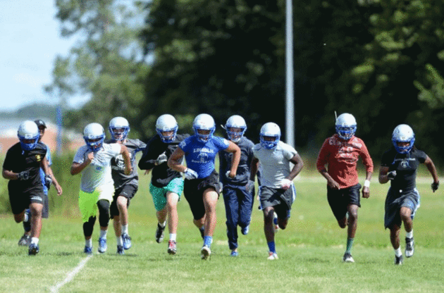
First Two Weeks of Football Practice The Most Dangerous for Heat-Related Illness. Coaches should pay attention to a story out of
The University of Georgia: "
As
the college football season heats up, a new University of Georgia study
finds players are more likely to suffer from heat-related illness
during the first two weeks of practice, especially those in the
Southeast. The four-year study evaluated the rates of exercise-related
heat illness among NCAA football players at 60 colleges across the U.S.
Bud Cooper, associate clinical professor in the department of
kinesiology at UGA's College of Education, said the results show the
need for players to get acclimated to the environmental conditions
during the first two weeks of practice-especially during hot weather.
"Environmental stress, especially hot weather, can be a key component
when assessing this stress," said Cooper, the lead author on the study.
"Certain variables can be manipulated to reduce that risk..." (File image: annarbor.com).
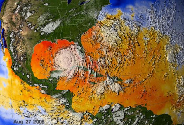
 Historic August Flood Caused by "Seemingly Innocuous" Disturbance, Louisiana's Climatologist Says
. Here's an excerpt of a story at
Baton Rouge Business Report that caught my eye: "...
To
be classified as a 1,000-year flood event, 21.3 inches of rainfall is
required, Keim says. Some areas in the Baton Rouge area far exceeded
that. Watson received a whopping
31.39 inches of rain. The Brownfields area saw 26.8 inches, and Denham
Springs had 25.5 inches. Keim says nine recording stations exceeded the
1,000-year flood mark. It was the heaviest rainfall on record in the
history of Louisiana. “Not only did we beat the record—we crushed it,” Keim says.
A flood of this magnitude originating from a small tropical wave is
very unusual, Keim says, but the high moisture in the atmosphere from
the Gulf of Mexico and the high humidity enabled the system. It was able
to take the moisture in the atmosphere and bring it to the ground, he
says..."
Poisonous Algae Blooms Threaten People, Ecosystems Across U.S. KQED and NPR have an eye-opening story that makes you want to stay out of the water; here's a clip: "Serious
algae outbreaks have hit more than 20 states this summer. Organisms are
shutting down beaches in Florida, sickening swimmers in Utah and
threatening ecosystems in California. The blooms are a normal part of
summer, but the frequency, size and toxicity this year are worse than
ever. And water managers are rattled. "Everyone's on edge with the
cyanobacteria," says Bev Anderson, a scientist with the California Water
Resources Control Board. Emails reporting outbreaks of cyanobacteria —
or blue-green algae — fill Anderson's inbox every morning..."
Photo credit: "
Officials
found the toxin microcystin in the blue-green algae present at
Discovery Bay, Calif. For people exposed to the toxin, symptoms include
dizziness, rashes, fever, vomiting and in more unusual cases, numbness.
" Lesley McClurg/KQED
Welcome to the Anthropocene. TIME has the story; here's the intro: "The
Earth has entered a new geological epoch defined by human impact,
scientists say. Humanity’s influence on the Earth is so great, an
entirely new geological epoch called the Anthropocene should be
declared, according to scientists from the Working Group on the
Anthropocene, who recommended the change to the International Geological
Congress in Cape Town on Monday, the Guardian
reported. The Anthropocene epoch should begin in about 1950, as
man-made developments ended the geological time defined by the current
epoch, the Holocene, the scientists said..."
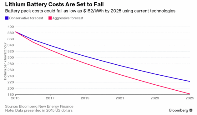
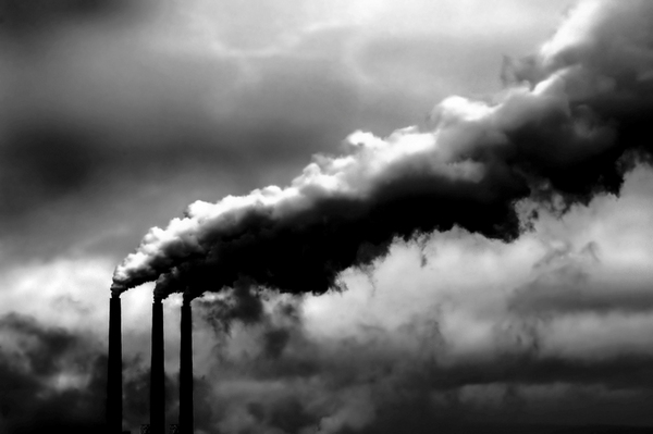
The $8 Trillion Fight Over How To Rid America of Fossil Fuels.
Bloomberg reports: "...
His
conclusions pivot on the price of—and estimated need for—nationwide
electricity storage. Assume that the U.S. needs enough backup for just
one day: Then renewables and batteries are already cheaper than
carbon-free nuclear reactors. Posit two days worth of storage, or, as
others have argued, a week: In that case, nuclear, which is economically
prohibitive today, becomes far and away the cheaper option, Heal says.
That leaves a range of answers to his main question. The investment to
make sufficient electricity to power America, with an 80 percent cut in
greenhouse gas emissions by 2050, would cost anywhere from $1.28
trillion to $5.28 trillion..."
It's Not Just Solar Panels. Electric Cars Can Be Contagious Too. Vox reports: "
We already know that solar power can be contagious.
Studies have found that if you install a rooftop solar system, it
increases the odds that your neighbors will too. Now along comes tantalizing evidence
that electric vehicles have a similar dynamic. When charging stations
are more visible, people become much more likely to consider buying a
plug-in car:
Placing charging
stations at workplaces, where cars spend much of their time, will be
uniquely powerful. When a workplace installs a charging station,
employees are 20 times as likely to buy a vehicle with a plug, according to a survey from the U.S. Department of Energy.
Graphic credit: "
Contagion, contagion everywhere!"
(Shutterstock).
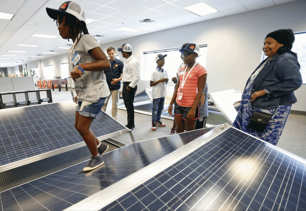
In Minnesota Churches, Let There Be Light - Solar Light. Why wouldn't churches, temples and mosques take advantage of (free) solar power? Here's an excerpt from The Star Tribune: "When
the Bible quotes God declaring “Let there be light,” it wasn’t exactly
referring to solar power. But across Minnesota, there’s been an
unprecedented surge in religious congregations installing rooftop solar
panels, subscribing to off-site solar “gardens” and urging their
faithful to do the same. The most ambitious project is slated for this
fall at Shiloh Temple International Ministries in north Minneapolis,
which will build a solar garden on its roof, make energy available for
up to 40 neighbors, and be part of a solar installation job-training
program for lower-income workers..."
Image credit: Jerry Holt, Star Tribune. "Maniya Dorsey, 9, toured Ten K Solar in Bloomington with her church group last week."
John Skipper is Steering ESPN Through Turbulent Times. Here's an excerpt from
The Washington Post: "...
But
the business model upon which ESPN was built may be going away.
Millennials especially are deciding they don’t need cable and are
instead turning to on-demand services and buying their programming a la
carte. ESPN’s subscription numbers are dropping, a trend that is costing
Disney, its parent company, hundreds of millions of dollars. “The whole
industry is struggling with the right answer,” said Rich Greenfield, a
media analyst with BTIG Research. “We have all these people growing up
and deciding they don’t need to spend the money. The tide is going out
on the whole sector...”
Photo credit: "
ESPN President John Skipper during a news conference in New York in 2014." (Mark Lennihan/Associated Press).
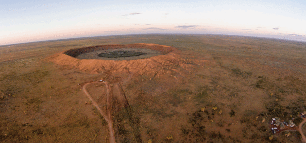
9 Incredible Meteorite Craters That Look Straight Out of "Deep Impact". Or Pink Floyd's "Dark Side of the Moon". Atlas Obscura has the list: "The
human species may not (yet) have encountered extraterrestrial life, but
our planet is pockmarked with the scars of alien visitors of a
different sort: the giant rocks that have come hurling out of space over
the millennia, hitting the Earth’s surface with such force a
gaping hole is left behind as a cosmic souvenir. There is a certain
unearthly beauty to these meteorite craters dotting the planet. In fact
their unique geology has been used as an analogue for outer space to
help astronauts train for the Moon landing or missions to Mars.
Others have given rise to gorgeous lakes and ancient cults or wiped out
the dinosaurs and other forms of life on the planet..."
Photo credit:
Stephan Ridgway/CC BY 2.0
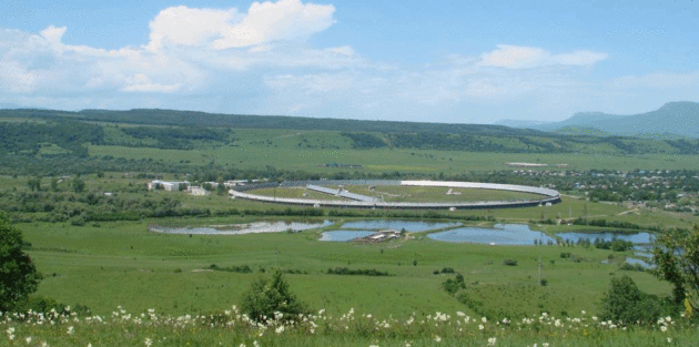
Not a Drill: SETI Is Investigating a Possible ET Signal from Space.
I have my doubts, but I wonder: would confirmation of an alien world
trigger better behavior on this planet - or sheer anarchy? Here's a
hair-raising article at Observer: "An
international team of scientists from the Search for Extraterrestrial
Intelligence (SETI) is investigating mysterious signal spikes emitting
from a 6.3-billion-year-old star in the constellation Hercules—95 light
years away from Earth. The implications are extraordinary and point to
the possibility of a civilization far more advanced than our own. The unusual signal was originally detected on May 15, 2015, by the Russian Academy of Science-operated RATAN-600 radio telescope in Zelenchukskaya, Russia, but was kept secret from the international community. Interstellar space reporter Paul Gilster broke the story after the researchers quietly circulated a paper announcing the detection of “a strong signal in the direction of HD164595...”
Photo credit: "The RATAN-600 Radio Telescope in Russia."
(Photo: Wikimedia Commons).
* Then again, this "bafflng signal" may be none of the above, according to this thread.
The Pentagon's Plan For Any Future Alien Visit (or Invasion) is Underwhelming. So says the author of a story at Mother Jones: "...How
would you plan for the arrival of an advanced civilization without any
understanding whatsoever of their capabilities, technology or
intentions?" He added that his sense was that the government had "little
if any idea" of what we'd be up against and "whatever it is would be so
far beyond us it would look and appear magical or spiritual, totally
beyond our ability to cope with or resist if hostile. If such an event
occurred we'd simply have to muddle through as best we could."
"Meanwhile," he says, "DoD has an overflowing plate already and I
suspect the Joint Staff has little patience for such seemingly unlikely,
open-ended and ill-defined scenarios..." (Image credit
here).
What Aliens Just Wouldn't Get About The Human Race.
CNN takes a crack at a long list.
Map Shows Most Popular Language In Each State Besides English and Spanish. Here's an excerpt from
wideopencountry.com: "...
This map created by Ben Blatt, of Slate,
shows the most common languages in every state after English and
Spanish. To create the map, Blatt examined data from the Census Bureau’s
American Community Survey,
which, in part, gathers information about the languages most commonly
used in American households. Survey participants are given a blank box
to write in their language rather than choose from a list of languages.
For more information about how Blatt compiled each language, check out
Blatt’s full article here..." (Map credit: Ben Blatt/Slate).
Surgeons Want to Transplant a Human Head - Really - and a Russian Is Offering His. Here's an excerpt of a bizarre and troubling story at
The Washington Post: "...
Sam Kean’s story about the project, published in the Atlantic magazine,
is deeply weird. Canavero says the transplant could happen as early as
2017 and has a “90 percent plus” chance of success. If it does take
place, it would require 80 surgeons and cost tens of millions of
dollars. Many scientists and ethicists have derided the project as “junk
science” that raises false hopes. One says that if Spiridonov dies — a
not-unlikely outcome — the doctors should be prosecuted for murder..."
Photo credit: "
Valery
Spiridonov, who has a disease that is usually fatal, has volunteered to
have his head transplanted to another person’s body." (Maxim Shipenkov/EPA).
TODAY: Comfortable sunshine, crisp breeze. Winds: N 7-12. High: 78
WEDNESDAY NIGHT: Clear and cool. Low: 55.
THURSDAY: Plenty of sun, good fair day. Winds: SE 5-10. High: 76
FRIDAY: Sunny with a mild breeze. Winds: S 10-15. Winds: S 10-15. Wake-up: 57. High: 78
SATURDAY: Partly sunny, last dry day in sight. Winds: S 10-20. Wake-up: 59. High: 79
SUNDAY: Sticky with showers and T-storms. Winds: S 10-15. Wake-up: 62. High: 76
LABOR DAY: Intervals of sun, nagging thunder risk. Winds: SW 7-12. Wake-up: 63. High: 82
TUESDAY: Unsettled, more showers and storms. Winds: S 10-15. Wake-up: 65. High: near 80
Climate Stories...
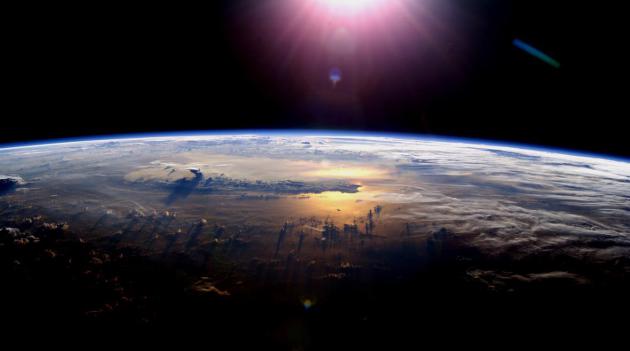
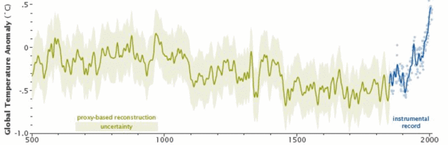
NASA: Earth is Warming At A Pace "Unprecedented in 1,000 Years". The Guardian explains: "
The
planet is warming at a pace not experienced within the past 1,000
years, at least, making it “very unlikely” that the world will stay
within a crucial temperature limit agreed by nations just last year,
according to Nasa’s top climate scientist. This year has already seen
scorching heat around the world, with the average global temperature peaking at 1.38C above levels experienced in the 19th century, perilously close to the 1.5C limit agreed in the landmark Paris climate accord. July was the warmest month since modern record keeping began in 1880, with each month since October 2015 setting a new high mark for heat..."
Graphic: NASA Earth Observatory.
The Toughest Question in Climate Change: Who Gets Saved?
When we talk about moving entire communities the politics will get very
sticky, especially when it comes to "who pays?" Here's an excerpt from
Bloomberg View: "...
The contest, called the National Disaster Resilience Competition,
was the first large-scale federal effort to highlight and support local
solutions for coping with climate change. It wound up demonstrating
something decidedly less upbeat: The federal government is still
struggling to figure out which communities should be moved, and when,
and how to pay for it. The importance of answering those questions is
shifting from hypothetical to urgent. The Alaskan town of Shishmaref
this month became the latest coastal community to vote
in favor of relocating; more will follow it. Figuring out who most
deserves money to move will only get more contentious as more places
raise their hand. If cutting emissions seems like a political nightmare,
just wait..." (File image: Andrew Demp, Yale).
 The "Social Cost of Carbon" Is The Most Historic Climate Change Decision Yet
.
The Daily Beast has details: "
One of the most significant court cases about climate change was decided
earlier this month by a federal appeals court in Chicago. Given that it
was steeped in the enervating context of refrigerator regulations, you
may have missed it. But amid the stultifying discussions of compressors
and insulation foam was a crucial advance in our nation’s belated
attempts to forestall global climate catastrophe. It all comes down to a
new phrase: the Social Cost of Carbon. Here’s why it’s important. By law, government agencies—in this case, the Department of Energy—are often required to show that the benefits of a proposed regulation exceed the costs..."
Illustration credit: Kelly Caminero/The Daily Beast.
The Challenge of Cutting Coal Dependence.
The New York Times reports: "
It
won’t be easy to get rid of coal. Worried the nation might miss its
2020 target to drastically cut emissions of carbon dioxide, the German
government proposed a steep levy last year on the most heavily polluting
generators. The tax was intended to deliver a decisive blow against
lignite or brown coal, the dirtiest fuel around and Germany’s main
source of electricity. Germany views itself as a leader in the push
against climate change.
It is probably the world’s most enthusiastic investor in renewable
energy, mainly wind and sun. But even the powerful Chancellor Angela
Merkel couldn’t quite pull it off..."
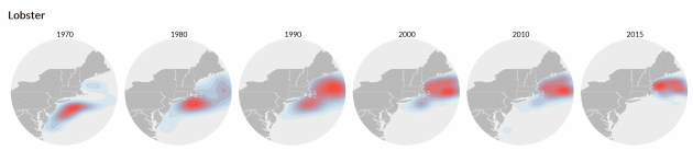
Beneath the Waves, Climate Change Puts Marine Life on the Move. The fish are shifting north as waters continue to warm, according to a story at
ctmirror.org: "...
We’ve
found quite dramatic shifts in where species are found,” said Malin
Pinsky, an ecologist and evolutionary biologist with the Rutgers
University Department of Ecology, Evolution and Natural Resources who
researches how climate change affects fish and fisheries. He has used
data collected by the National Oceanic and Atmospheric Administration to
create OceanAdapt, which includes animations that regionally show
how dozens of marine species have moved in the last 50 years.
“Especially here in the Northeast you have something like American
lobster about 200 miles further north than they used to be, and other
species shifting similar amounts...”
Image credit: "
Using
data collected by the National Oceanic and Atmospheric Administration,
Malin Pinsky of Rutgers University has shown that marine species in the
northeast Atlantic Ocean have moved generally north and east in the last
few decades. This is thought to be precipitated by warmer waters due to
climate change. Distribution is indicated from low to high."
Why It Matters: Climate Change. Seth Borenstein explains at
The Big Story from AP, complete with links and compelling evidence: "...
Dozens of measurements show Earth is warming. And it's worsening. The overwhelming majority of climate scientists and nearly every professional organization of scientists have said climate change is real, man-made and a problem. The last 15 months in a row
have set records globally for heat, according to the National Oceanic
and Atmospheric Administration. The world is on pace to break the record
for hottest year, a record broken in 2010, 2014 and 2015. The five hottest years recorded have all been from 2005 on and it is about 1.8 degrees warmer than a century ago. But it's more than temperatures. Arctic sea ice keeps flirting with record low amounts. Hot water has been killing coral as never before seen. Scientists have connected man-made climate change to extreme weather , including deadly heat waves , droughts and flood-inducing downpours . They even have connected it as one of several factors in the Syrian drought and civil war that led to a massive refugee crisis..."
 Grasping Climate Change.
 Phil Plait explains why it's so hard for our brains to grasp at
Slate: "
And
that is the true evil of climate change. It’s slow, and patient. It’s
everywhere, but takes its time. It operates every day, but its effects
don’t manifest for decades. Weather changes every day, every hour, and
that noise washes out the signal of climate change. Unless, that is, we
too are patient, and keep our eyes on the long view. When we do, we see
the trend, not the bumps and wiggles. This short, one-minute video
frames it the best way I have ever seen: as a person walking a dog: If
we watch the trend, and not the wiggles, we see the impact of humanity
on our planet. The temperature trend is actually quite clear now. And
that trend is up..." (File photo: Santiago Borja).


No comments:
Post a Comment