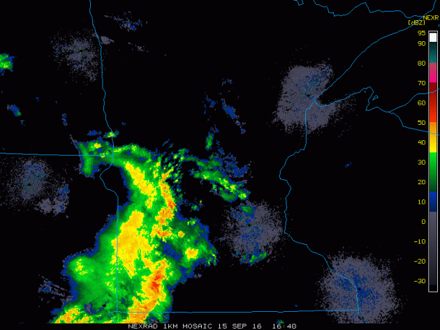
Thursday Storms
Thunderstorms blew up along the leading edge of a cool front on Thursday afternoon. Here's a look at the line as it approached the Twin Cities from the West-Southwest. Up to 5" of rain fell across parts of southern Minnesota as this line of showers and storms moved through.
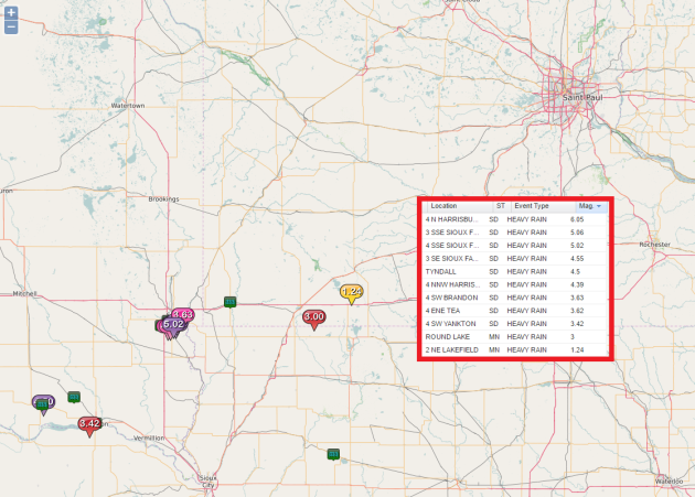
Heavy Rain
Here are some of the heavy rainfall reports that came in on Thursday near Sioux Falls, SD. Some spots here saw as much as 3" to 6" of rain!
Large Low Pressure
The visible satellite loop from Thursday shows a fairly mature storm system centered over the Dakotas. Interestingly, this is the same storm that brought snow to some of the mountains in the Western U.S.. Due to the slow moving nature of this storm, scattered showers and storms will linger across the Upper Midwest on Friday with a slow clearing trend taking place on Saturday.
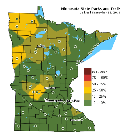
Fall Color Update
According to the MN DNR, we are well on our way in the fall color department with some 25%-50% color being reported across parts of Central and Northwestern Minnesota. Keep in mind that the average peak for the Twin Cities is generally late September to mid October.
 ___________________________________________________
Soggy Friday gives way to more sun late weekend
We certainly haven't had an issue with dry weather over the last several weeks and months have we? Timely bouts of heavy rain have many lawns looking quite lush. My gas can in the garage is spider web free as it has been getting regular reps filling up the lawnmower this summer. And at this rate, I don't see any slowing in lawn mowing duties anytime soon.
A slow moving storm system responsible for mountain snow out West earlier this week, will churn through the Upper Midwest today with continued thundershower chances. Weather conditions look a little drier for prep football games this evening, but it might not be a bad idea to drag something waterproof along if your travels take you north and east.
Stubborn clouds and spits of light rain rotate around the low as it works through northeastern Minnesota on Saturday. Sunday will be the pick day of the weekend with bright sun and temps in the 70s.
According to the U.S. Drought Monitor, Minnesota is drought free, while 21% of California is in an Exceptional Drought.
____________________________________________________
____________________________________________________
Extended Weather Outlook
THURSDAY NIGHT: Scattered storms early. Winds: SE 5. Low: 64
FRIDAY: Humid with peeks of sun, stray T-shower risk. Winds: SSW 5-15. High: 74
FRIDAY NIGHT: Slight thunder chance early. Winds: W 5. Low: 57.
SATURDAY: Slow clearing trend, showers north. Winds: WNW 5-10. High: 68
SUNDAY: Bright sun, warmer winds. Winds: S 10-15. Wake-up: 53. High: 77
MONDAY: Breezy. Spotty PM thunder. Winds: NW 5-15. Wake-up: 61. High: near 80
TUESDAY: Sunny, warm and pleasant. Winds: NW 5-10. Wake-up: 57. High: 75
WEDNESDAY: More wind. PM storms develop. Winds: SE 10-20. Wake-up: 60. High: 74
THURSDAY: Lingering clouds and showers. Winds: NE 10-15. Wake-up: 57. High: 71.
_______________________________
_______________________________
This Day in Weather History
September 16th
September 16th
1992: New Market receives nearly a foot of rain. A bridge collapses during a flood in northern Le Sueur County.
1955: An F1 tornado touches down in Mille Lacs and Kanabec Counties, causing 1 fatality and $500,000 in damages.
2006: A rapidly forming tornado hits Rogers just before 10pm, causing one fatality.
________________________________
Average High/Low for Minneapolis
September 16th
September 16th
Average High: 72F (Record: 94F set in 1955)
Average Low: 52F (Record: 38F set in 1873)
_________________________________
Average Low: 52F (Record: 38F set in 1873)
_________________________________
Sunrise/Sunset Times for Minneapolis
September 16th
September 16th
Sunrise: 6:53am
Sunset: 7:21pm
Sunset: 7:21pm
*Daylight Lost Since Yesterday: ~3mins & 5sec
*Daylight Lost Since Summer Solstice: ~3hours and 6mins
__________________________________
*Daylight Lost Since Summer Solstice: ~3hours and 6mins
__________________________________
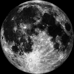
Moon Phase for September 16th
Full HARVEST Moon at 2:05pm CDT
Full HARVEST Moon at 2:05pm CDT
"The Full Harvest Moon. Traditionally, this designation goes to the full moon that occurs closest to the autumnal equinox. At the peak of the harvest, farmers can work into the night by the light of this moon. Usually the full moon rises an average of 50 minutes later each night, but for the few nights around the Harvest Moon, the moon seems to rise at nearly the same time each night: just 25 to 30 minutes later across the United States, and only 10 to 20 minutes later for much of Canada and Europe. Corn, pumpkins, squash, beans and wild rice — the chief Indian staples — are now ready for gathering."
___________________________________
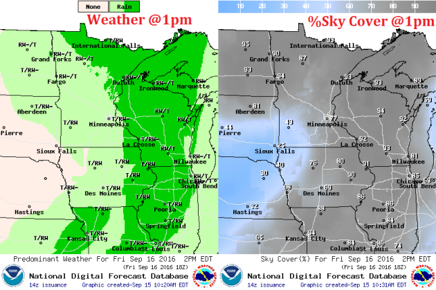
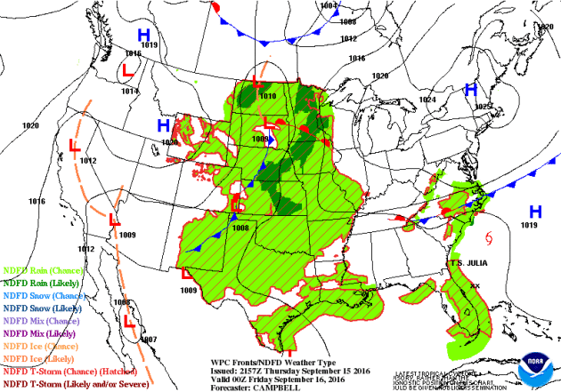
Weather Outlook Friday
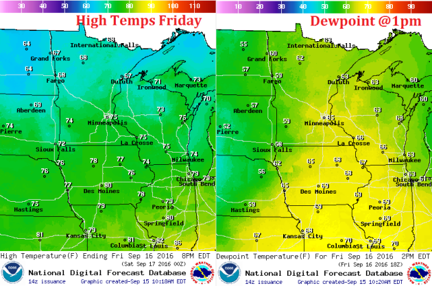
Scattered showers and storms will continue to rotate around an area of low pressure that will continue to slowly push through the Upper Midwest on Friday. Temperatures will be in the 70s across the southern half of the state with dewpoints in the mid 60s, so it'll feel a little muggy. Meanwhile, temperatures across the northern part of the state will hang steady in the mid/upper 60s.
Weather Outlook Friday
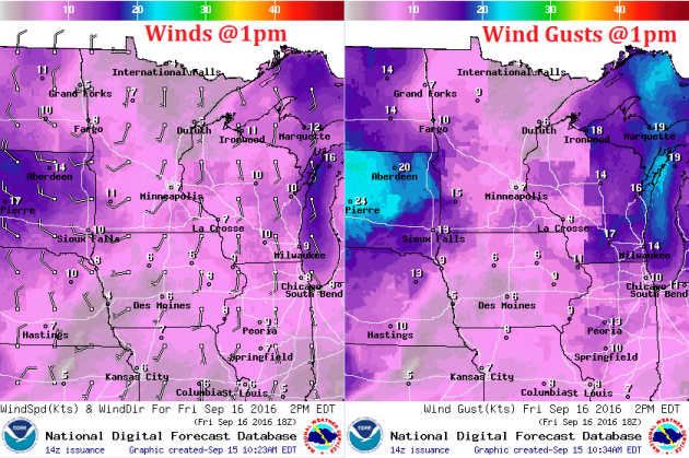
Note the counter-clockwise circulation in the wind field with the center of circulation located in far northwestern Minnesota around midday. This is the are of low pressure responsible for our scattered showers and storms on Thursday and Friday. Winds will pick up a bit across the Dakotas with some wind gusts approaching 20 to 25mph+.
Weather Outlook Friday
The heaviest precipitation looks to push east of the Mississippi River Valley by midday Friday with lingering showers and storms possible during the afternoon hours. Note that parts of far southwestern Minnesota could break out into a little sunshine later, while thick clouds continue to hover over northern Minnesota and all of Wisconsin.
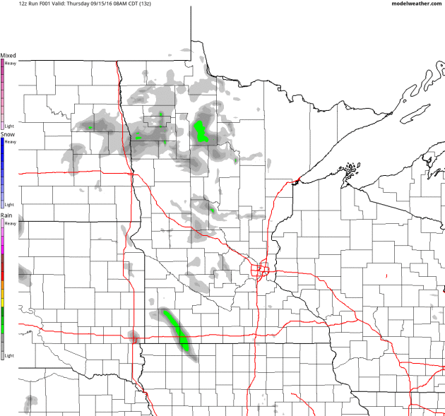
Simulated Radar
The simulated radar from AM Thursday to PM Saturday shows scattered showers and storms moving into the region during the PM hours on Thursday and lingering across the area on Friday. Wrap around moisture will be found across the northern/northeastern part of Minnesota and northern Wisconsin no Saturday with skies becoming mostly clear and sunny on Sunday.
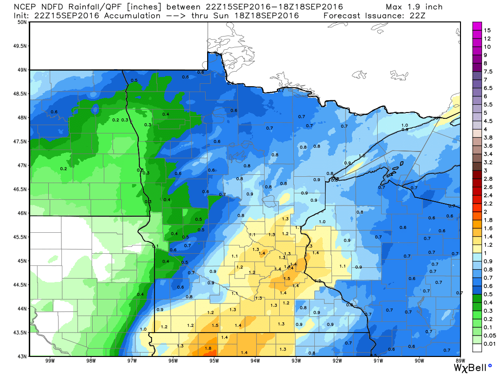
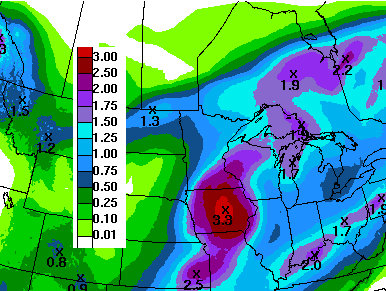
Rainfall Potential
Here's the rainfall potential through PM Saturday, which suggests some fairly decent amounts of rain with the initial line of storms that moved through PM Thursday. Lingering showers and storms look to continue to push through the region Friday and perhaps on Saturday. In total, some locations could see up to 1" of rain or more through Saturday.
__________________________________________
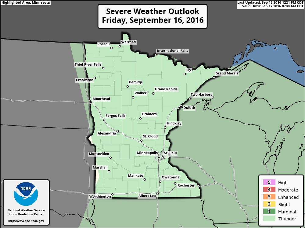
Severe Threat Friday
While NOAA's Storm Prediction Center does not have a severe risk for Minnesota on Friday, there is still a risk of general thunderstorms with lightning and locally heavy downpours.
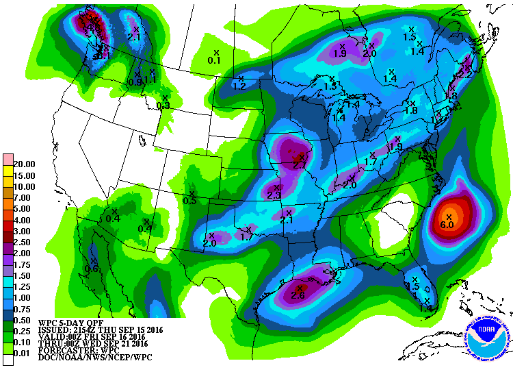
7 Day Rainfall Outlook
According to NOAA's WPC, the 7 day precipitation forecast suggests 1" to 2"+ rainfall tallies across the Upper Midwest as 2 different storms impact the area. The first storm from Thursday - Saturday will bring some 1"+ amounts to a few locations, while another larger storm looks to develop by the middle/end of next week.
Extended Weather Outlook
Mild temperatures ahead! Keep in mind that our average high in the Twin Cities is in the low 70s now, so after temperatures briefly getting back to near average readings on Friday and Saturday, it appears that above average temperatures returns for much of next week! The extended forecast is sniffing out some 60s by the last weekend of September... Stay tuned!
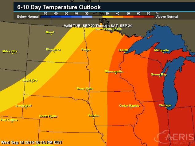
6 to 10 Day Temp Outlook
According to NOAA's CPC, the 6 to 10 day temperature outlook suggests warmer than average temperatures will be with much of the Midwest and Great Lakes region during much of next week! Good news for folks that aren't quite ready for fall-like weather just yet.
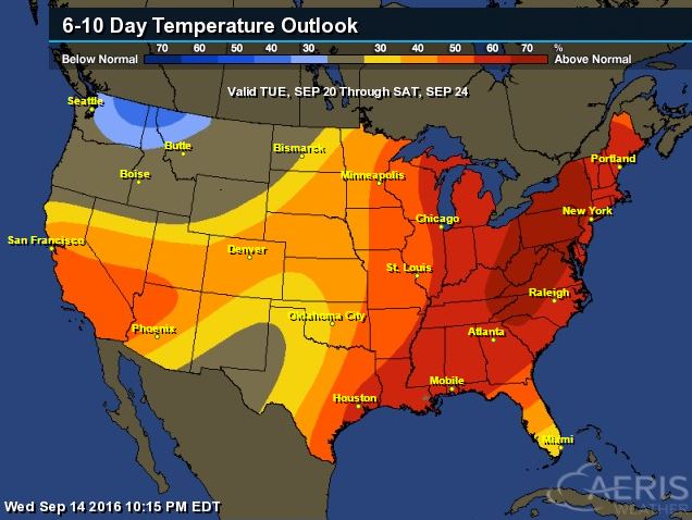
6 to 10 Day Temp Outlook
Here's a look at the national temperature outlook, which suggests that much of the nation and especially the eastern half of the country will be above average from September 20th - 24th. Note that there appears to be a dip of cold air moving in from the Pacific Northwest once again. This may help to bring parts of the Midwest cooler temps by the last weekend of September. Stay tuned!
__________________________________________
National Weather Outlook
Take a look at the slow moving area of low pressure in the middle part of the country. This particular storm system brought snow to the high elevations in the Western U.S. and heavy rain to parts of the Central U.S. on Thursday. The slow progression east will allow additional heavy rainfall potential to fall from the Great Lakes to the middle part of the country on Friday and Saturday.
Precipitation Outlook
Heavy rainfall potential will be possible across the central part of the country over the next few days. Some spots could see up to 1" to 2"+ through the early part of next week. Note also the heavier blob of rain off the Mid-Atlantic coast in association with the remnants of Ian.
__________________________________________
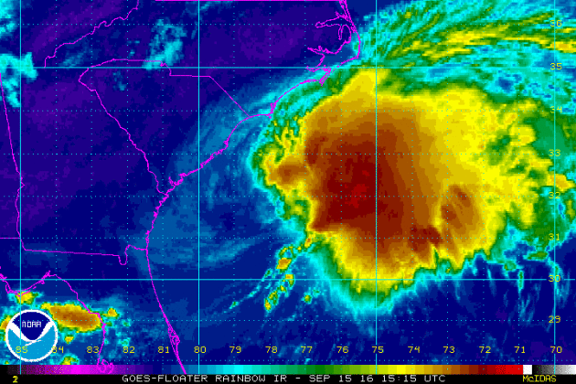
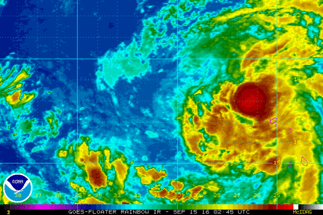
JULIA
Here's a look at Julia from Thursday evening. Julia has been an interesting storm that according to NOAA's NHC had a low chance of tropical development earlier this week and then turned into a Tropical Storm. Is lost a little steam as in moved over South Carolina and dropped a lot of rain. It then moved back over the warm Atlantic waters and regained tropical storm status on Thursday.
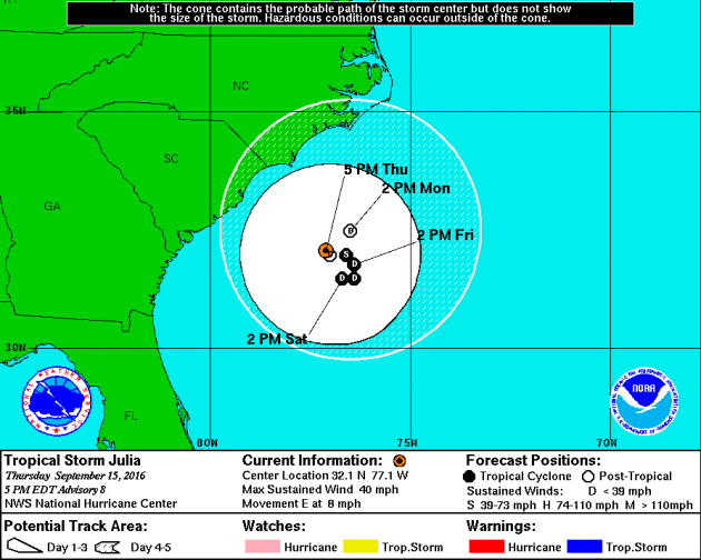
Tracking Julia
According to NOAA's NHC, Julia looks to wobble offshore for another few days and drop to tropical depression status once again. A few showers on the outer bands of Julia may still impact the East Coast.
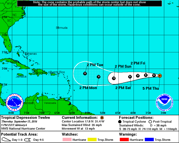
Tropical Depression TWELVE
There is another storm that we are watching just off the western tip of Africa. Say hello to Tropical Depression TWELVE, which may become Karl at some point as the storm drifts west.
Tracking TWELVE
Here's T.D. Twelve's track, which shows it becoming a tropical storm by late this weekend. If so, this would become Karl and the 11th named storm of the 2016 Atlantic Hurricane Season.
____________________________________
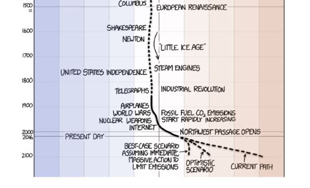
"Epic Climate Cartoon Goes Viral, But It Has One Key Problem"
"From anthrax outbreaks in thawing permafrost to rice farms flooded with salty water, climate change seems to play a bigger and bigger role in global health each year. But sometimes it can be hard to grasp what all the numbers and stats mean. For instance, when scientists say Earth's average surface temperature has gone up about 1 degree Celsius over the past 150 years or so, what does that really mean? Besides, hasn't Earth's temperature always fluctuated? Now a cartoon from Randall Munroe, a former roboticist at NASA and founder of the website xkcd, helps put the numbers into perspective. Before scrolling through it, check out those axes. Along the x-axis is temperature change. And each vertical block of color is 1 degree Celsius or 1.8 degrees Fahrenheit. On the y-axis, we've got time. The whole cartoon, which starts at the end of the last ice age, represents about 22,000 years. People have been around for about 200,000 years. The dinosaurs were around about 65 million years ago. And Earth is 4.5 billion years old. So the graph is only a teeny-tiny period of Earth's lifetime."
 ____________________________________________
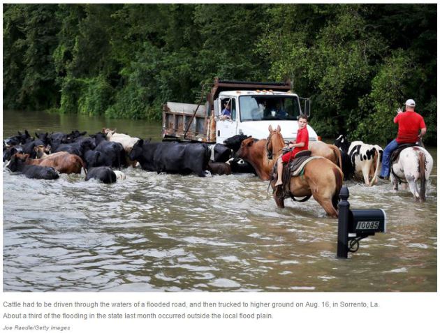
"Outdated FEMA Flood Maps Don't Account For Climate Change"
"The floods that hit Louisiana last month were caused by rainfall that was unlike anything seen there in centuries. Most of the southern part of the state was drenched with up to two or three inches in an hour. A total of 31 inches fell just northeast of Baton Rouge in about three days; 20 parishes were declared federal disaster areas. Climate scientists and flood managers suspect there could more like that to come — in Louisiana and in other parts of the country. There have always been extraordinary rainstorms — storms stronger than anyone can remember. But Nicholas Pinter, a geologist at the University of California, Davis, who researches floods, says we shouldn't write these off as once-in-a-lifetime freak events. "[In] our experience," Pinter says, "these kind of — call them 'acts of God explanations' — are served up just a little too easily." Sure, he says, amazing rainstorms do happen. But lately, big floods seem to be following storms more often. "Hundred-year floods — floods of a magnitude that usually occur only once a century — [and] other large [weather] events are occurring bigger and more frequently than the published probabilities predict," Pinter says. And some of those floods look different."
______________________________________________
"Military Leaders Warn That Climate Poses Security Threats"
"A bipartisan group of defense experts and former military leaders are calling on the next administration to consider climate change as a grave threat to national security. It’s not just about protecting military bases from sea-level rise, they argue in a climate consensus statement issued this morning in advance of today’s Climate and National Security Forum. The effects of climate change present a risk to U.S. national security and international security, and the United States should advance a comprehensive policy for addressing the risk, its authors say. The Pentagon must game out catastrophic climate scenarios, track trends in climate impacts and collaborate with civilian communities, they say. Stresses from climate change can increase the likelihood of international or civil conflict, state failure, mass migration and instability in strategically significant areas around the world. Climate change presents a significant and direct risk to U.S. military readiness, operations and strategy—and military leaders say it should transcend politics."

____________________________________________
Thanks for checking in and have a great end of the week and weekend ahead!
Don't forget to follow me on Twitter @TNelsonWX
Don't forget to follow me on Twitter @TNelsonWX

No comments:
Post a Comment