Ryder Cup Excellence
"This week was magical because of the beautiful Minnesota weather."
Davis Love II - Captain of the 2016 USA Ryder Cup Team
What an excellent stretch of weather we had for the Ryder Cup at Hazeltine in Chaska, MN! The course looked amazing and the weather made it sparkle even more. Congrats to everyone who helped make it great!


 -Image below courtesy Wade Weidner-

"This week was magical because of the beautiful Minnesota weather."
Davis Love II - Captain of the 2016 USA Ryder Cup Team
What an excellent stretch of weather we had for the Ryder Cup at Hazeltine in Chaska, MN! The course looked amazing and the weather made it sparkle even more. Congrats to everyone who helped make it great!
_______________________________________________
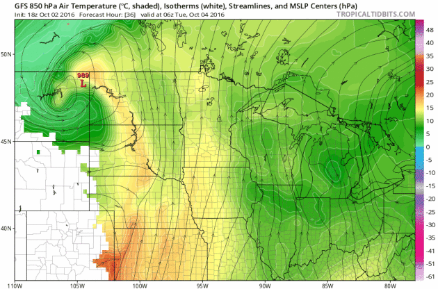
Storm System Next Week
A storm system brewing in the Western U.S. will move into the Upper Midwest by the middle part of next week with scattered showers and storms along the cold front. Heavier rainfall potential may be possible along the cold front as it moves through the Mississippi River Valley. Note that temperatures may even be cold enough for snow potential across NW North Dakota.
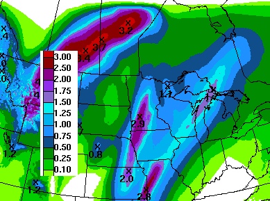
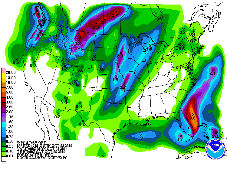
Heavy Rainfall Potential Returns
Here's the 7 day rainfall potential, which suggests heavier rain possibly moving back into the Upper Midwest by the middle part of next week. Some locations could see up to an additional 1" to 2" through next weekend.
Turning Colder Next Week
Temperatures ahead of the cold front will warm into the 70s through the early part of next week, but note how much cooler it gets post front by the middle/end of next week. I wouldn't be surprised to see more frost and freeze concerns develop by the end of next week.
_________________________________________
Hurricane Matthew
Hurricane Matthew became the 5th hurricane of the 2016 Atlantic hurricane season on Thursday and strengthened rapidly into a MAJOR category 3 hurricane Friday morning. Overnight Friday, Matthew strengthened even more into a category 5 storm with sustained winds up to 160mph. Interestingly, Matthew became the first category 5 hurricane in the Atlantic Basin since Hurricane Felix in 2007. Matthew is located in the Caribbean and is expected to lift straight north this weekend toward Cuba and the Bahamas by early next week.
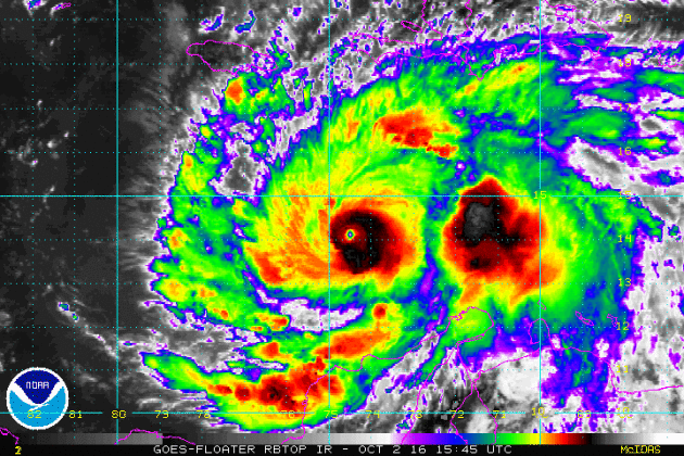
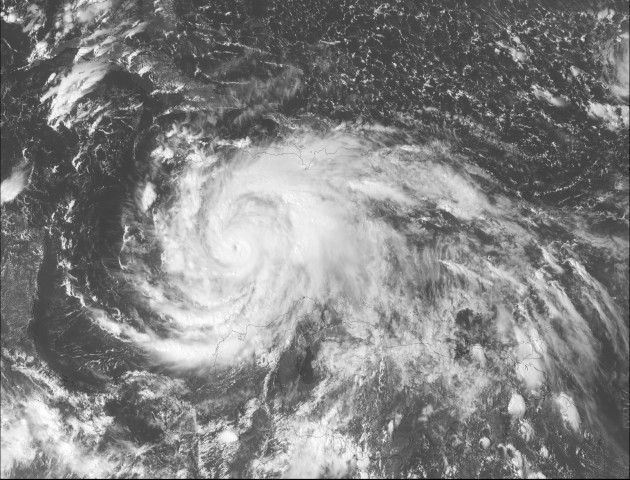
After strengthening into a category 5 hurricane (the first in 9 years; since Felix in 2007), models project that we may still see major hurricane strength (category 3 or higher) over the next few days.
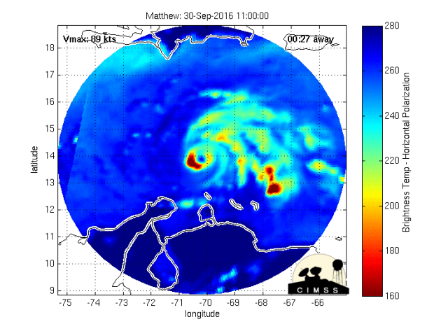
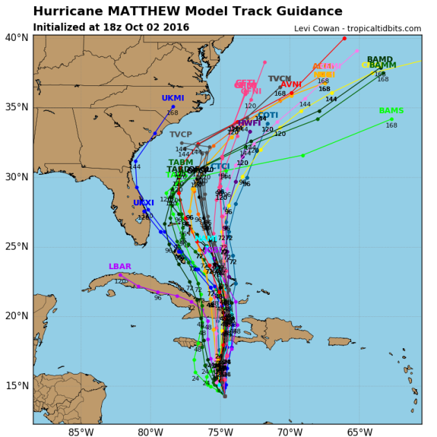
Tracking Matthew
Hurricane watches and warnings have been issued for a number of locations in advance of Matthew. The official track from the National Hurricane Center suggests Matthew will continue at major hurricane strength through early and middle part of next week as it makes a close encounter with Jamaica, Haiti and slides over eastern Cuba. Note that the the northerly track takes it over the Bahamas by the middle/end of next week as a major hurricane.
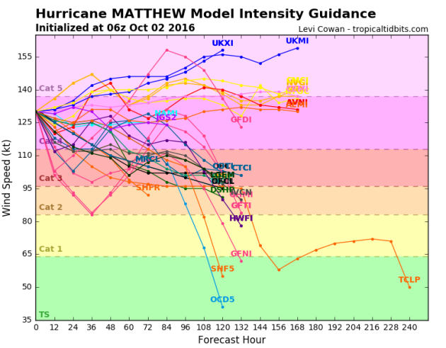
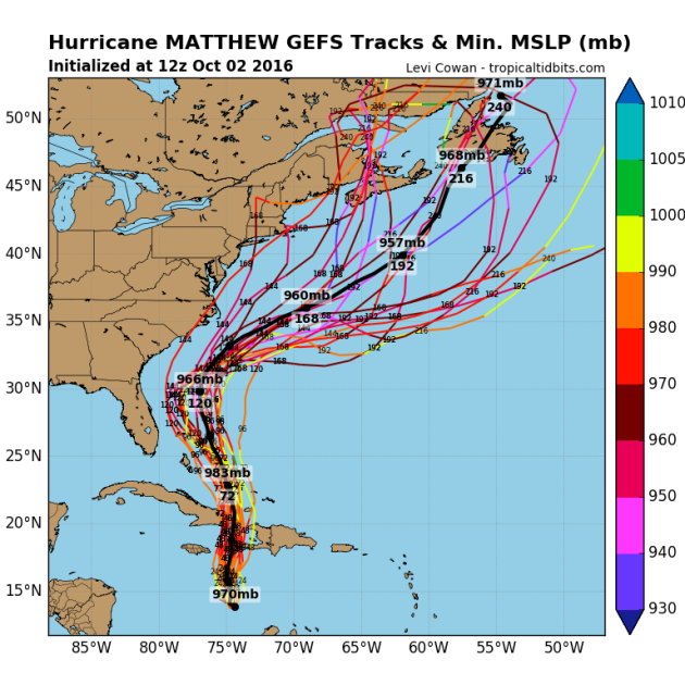
Here are a few different model solutions for Matthew. Note that most are pretty consistent as it tracks over eastern Cuba and the Bahamas early next week. The extended forecast for mid/late week gets a little hairy as some track the system into the Eastern U.S., while others take it out into the Atlantic Ocean.
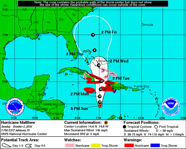
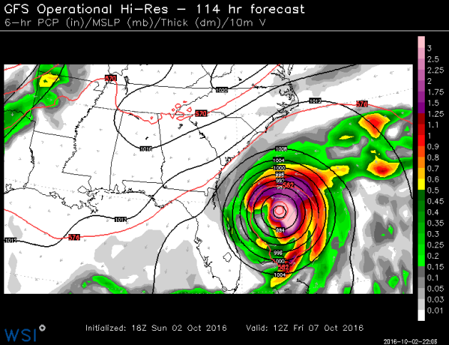
Here's the latest GFS track for Matthew by late week. Note that the storm looks to potentially take a very close track to the east coast of Florida and the Mid-Atlantic.
___________________________________
Signs of fall are starting to pop a little more each and every day. Things are a little more advanced across the central and northern part of the state, but we're getting there.

Monday looks like another brilliant day with continued sunshine and temperatures warming into the low/mid 70s across much of the state. A southeast breeze kicks up a little this afternoon in advance of a storm system that will bring widely scattered showers and storms late tomorrow. Some of the rain could be heavy at times; some spots could see an additional 1 to 2 inches by Wednesday.
Jacket-worthy weather returns late this week as temperatures dip into the low/mid 50s. It'll feel like late October with overnight lows reaching frost and freeze levels across the northern half of the state. Some models are even hinting at the potential of flurries across the international border this weekend!
Meanwhile, hurricane watches and warnings continue in advance of "Matthew" heading toward the Bahamas midweek.
___________________________________________________
1922: A hot fall day occurs in Minnesota. Notable highs are 95 in Ada and 93 at Moorhead.
________________________________
Average High/Low for Minneapolis
October 3rd
 _______________________________________________________________________
___________________________________________________________
 ___________________________________________
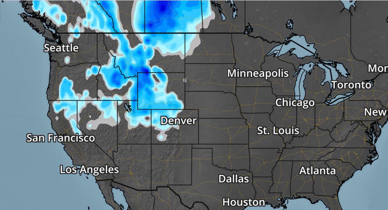
.gif) Snowfall Potential
Snowfall Potential
As the storm system works inland, moisture will turn to snow across the higher elevations from the Sierra Nevada Range to the Colorado Rockies. There may even be a little snow in the lower elevations along the Front Range.

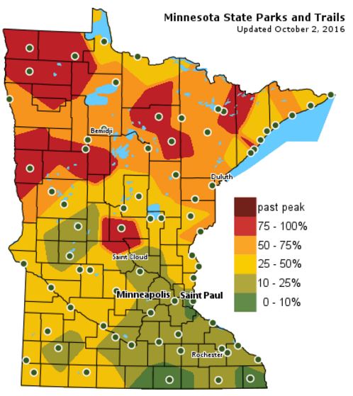
Fall Color Update
The latest update from the MN DNR shows that we are well on our way in the fall color department with some peak colors (75% - 100%) color being reported across parts of Central and Northwestern Minnesota. Note that only 10% to 25% color can be found across the Twin Cities; the average peak there is generally late September to mid October.
_______________________________________________
Approaching storm brings heavy rain and cold temps
I think Mother Nature was looking out for us. One of the world's biggest golf stages was set in our own backyard. Hazeltine looked amazing already, but the pristine early fall weather helped to make it sparkle even more. WOW!Monday looks like another brilliant day with continued sunshine and temperatures warming into the low/mid 70s across much of the state. A southeast breeze kicks up a little this afternoon in advance of a storm system that will bring widely scattered showers and storms late tomorrow. Some of the rain could be heavy at times; some spots could see an additional 1 to 2 inches by Wednesday.
Jacket-worthy weather returns late this week as temperatures dip into the low/mid 50s. It'll feel like late October with overnight lows reaching frost and freeze levels across the northern half of the state. Some models are even hinting at the potential of flurries across the international border this weekend!
Meanwhile, hurricane watches and warnings continue in advance of "Matthew" heading toward the Bahamas midweek.
___________________________________________________
Extended Weather Outlook
SUNDAY NIGHT: Mostly clear and quiet. Winds: E 5. Low: 53
MONDAY: Mostly sunny and mild. Winds: SE 10-20. High: 73
MONDAY NIGHT: Partly cloudy and quiet. Winds: SE 10. Low: 58.
TUESDAY: Breezy with scattered storms later. Winds: SSE 15-25. High: 71
WEDNESDAY: Soggy start. Gradual PM clearing. Winds: W 10-15. Wake-up: 59. High: 68
THURSDAY: Cooler. Clouds return with a few showers. Winds: WNW 10-15. Wake-up: 48. High: 59.
FRIDAY: Feels like late October. Frost up north. Winds: NW 10-15. Wake-up: 42. High: 54.
SATURDAY: More sun. Jacket-worthy. Winds: NNE 5-10. Wake-up: 38. High: 55.
SUNDAY: More chilly sunshine. Dry. Winds: ESE 5-10. Wake-up: 39. High: 59.
_______________________________
_______________________________
This Day in Weather History
October 3rd
1999: The earliest ever single digit temperature in Minnesota is recorded at Embarrass, with a low of 9.October 3rd
1922: A hot fall day occurs in Minnesota. Notable highs are 95 in Ada and 93 at Moorhead.
________________________________
Average High/Low for Minneapolis
October 3rd
Average High: 64F (Record: 90F set in 1997)
Average Low: 45F (Record: 26F set in 1996)
_________________________________
Average Low: 45F (Record: 26F set in 1996)
_________________________________
Sunrise/Sunset Times for Minneapolis
October 3rd
October 3rd
Sunrise: 7:14am
Sunset: 6:49pm
Sunset: 6:49pm
*Daylight Lost Since Yesterday: ~3mins & 5sec
*Daylight Lost Since Summer Solstice: ~4hours and 2mins
______________________________________________________________________
*Daylight Lost Since Summer Solstice: ~4hours and 2mins
______________________________________________________________________
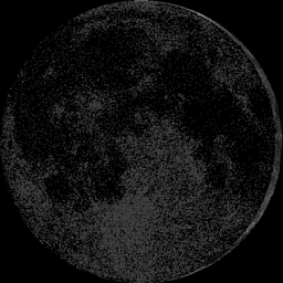
Moon Phase for October 3rd at Midnight
3.3 Days Since New Moon
3.3 Days Since New Moon
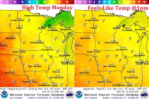
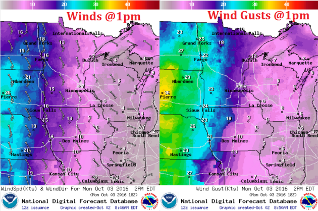
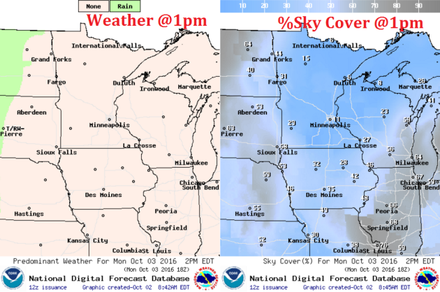
Weather Outlook Monday
High temperatures on Monday will once again be warmer than average with highs approaching the low to mid 70s across much of the state. The only difference between Sunday and Monday will be a stronger wind that develops by the afternoon hours.
Weather Outlook Monday
Winds on Monday will become a little stronger by the afternoon hours, especially across the western part of the state, where some 20mph+ wind gusts will be possible. These stronger winds will be ahead of a developing storm system that will bring us scattered showers and storms Tuesday and Wednesday with late October-like winds developing later this week.
Weather Outlook Monday
Monday looks to be another fairly decent day with mild temperatures and plenty of sunshine. The only issue may be a little stronger wind by the afternoon. Enjoy the mostly quiet day as clouds and scattered storms return Tuesday.
___________________________________________________________
Simulated Radar
The simulated radar from Sunday to Wednesday shows mostly dry weather continuing across the region Monday with weather conditions souring a bit Tuesday as a line of showers and storms moves in. Some of the rain could be heavy at times.
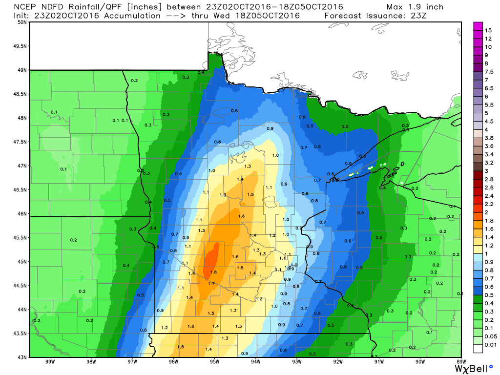
Rainfall Potential
Rainfall potential through Wednesday suggests scattered showers and storms moving into the state by PM Tuesday with locally heavy rainfall potential. Some spots could see up to 1" or more through midweek.
_________________________________________
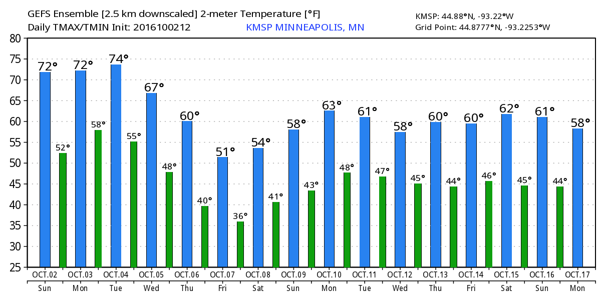
Extended Weather Outlook
The extended temperature outlook over the next 16 days suggests temperatures warming to near 70F over the next few days and into early next week. A fairly significant cold front sweeps through by the middle/end of next week. High temperatures by the second of October looks to be potentially very chilly.
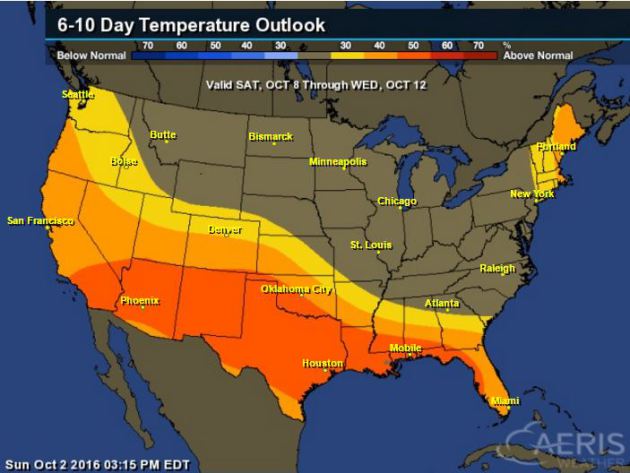
6 to 10 Day Temp Outlook
Here's the national temperature outlook from October 8th - 12th, which shows warmer than average conditions across the southern half of the nation with neutral temps across the northern half of the nation.
__________________________________________
National Weather Outlook
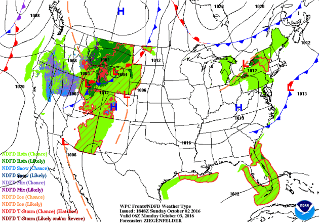
The next storm system will move into the Central U.S. with scattered showers and storms by midweek. Prior to that, parts of the Intermountain West will see mountain snow.
Precipitation Outlook
The heaviest rainfall over the next few days will once again develop across the Central U.S. as our next storm system moves in. There will also be heavier precipitation across the West Coast and the High Plains. Also note the heavy precipitation just east of the East Coast, this is associated with "Matthew".
___________________________________________
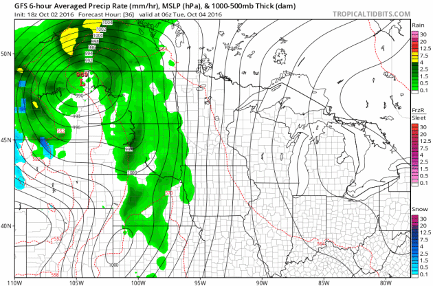
Western Storm System
The next storm system is forecast to move into the Western U.S. with some gusto by this weekend and early next week. Gusty winds, colder temps and high elevation snow will be possible. Interestingly, this storm will bring chances of widespread rain/thunder to the Upper Midwest by the middle part of next week.
As the storm system works inland, moisture will turn to snow across the higher elevations from the Sierra Nevada Range to the Colorado Rockies. There may even be a little snow in the lower elevations along the Front Range.
_______________________________________________________
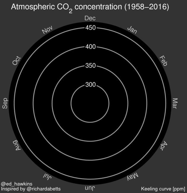
"OK Fine, Here’s the Carbon Dioxide Spiral"
"The world has blown past the 400 parts per million carbon dioxide milestone, and is unlikely to return below that threshold again in our lifetimes. It’s the biggest climate news of the week and quite possibly, the year. And it’s also a sobering reminder of what our carbon pollution problem is doing to the world. With that in mind, perhaps you’ve ruminated on it and stared at the Keeling Curve, trying to fathom how we got here. But if it hasn’t fully sunk in yet, please take a look at the carbon dioxide spiral below to get a grip on what our new reality looks like."
 __________________________________________________________________
"The world has blown past the 400 parts per million carbon dioxide milestone, and is unlikely to return below that threshold again in our lifetimes. It’s the biggest climate news of the week and quite possibly, the year. And it’s also a sobering reminder of what our carbon pollution problem is doing to the world. With that in mind, perhaps you’ve ruminated on it and stared at the Keeling Curve, trying to fathom how we got here. But if it hasn’t fully sunk in yet, please take a look at the carbon dioxide spiral below to get a grip on what our new reality looks like."
Thanks for checking in and don't forget to follow me on Twitter @TNelsonWX
No comments:
Post a Comment