Hurricane Matthew - The Threat is Real
After battering Haiti, eastern Cuba and parts of the Bahamas with hurricane force winds and exceptional rainfall, Matthew is now on track to impact the Southeastern U.S. later this week and weekend. Latest forecasts have Matthew sustaining Major hurricane status (category 3 or higher) as it nears Florida by Friday.
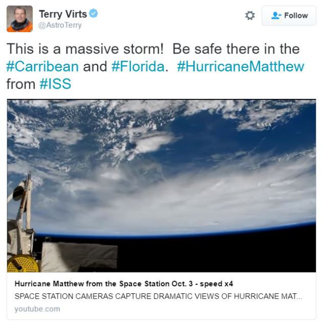
 Matthew from the International Space Station
Take a look at this video that Terry Virts @AstroTerry posted as he flew over Hurricane Matthew from aboard the International Space Station midweek.
See the video HERE
___________________________________
Florida Bracing for Matthew
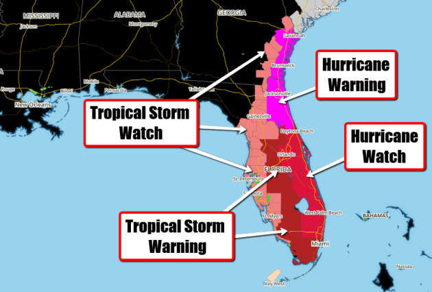
Hurricane Watches and Warnings have been posted for parts of Florida and Georgia in advance of Matthew as it continues to slowly drift northwest toward the Peninsula. Latest forecast tracks take this along the east coast of Florida later this week/weekend ahead with significant impacts. Mandatory evacuations have already been order for parts of the state as Matthew threatens.

________________________________________
Hurricane Matthew

____________________________________
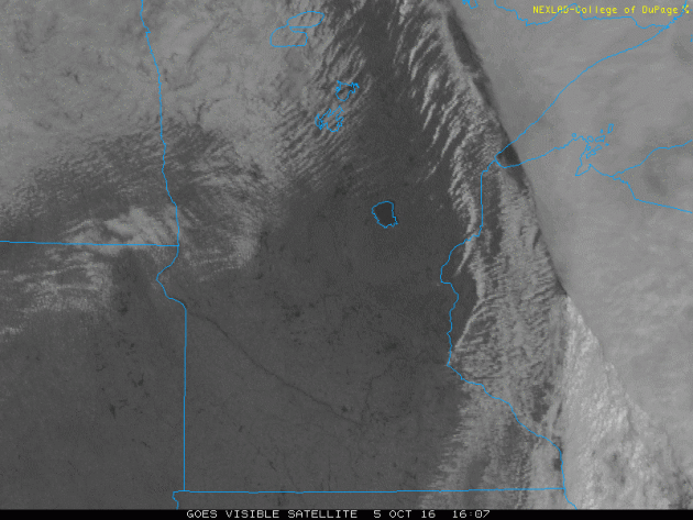
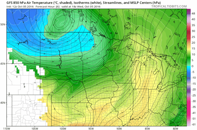
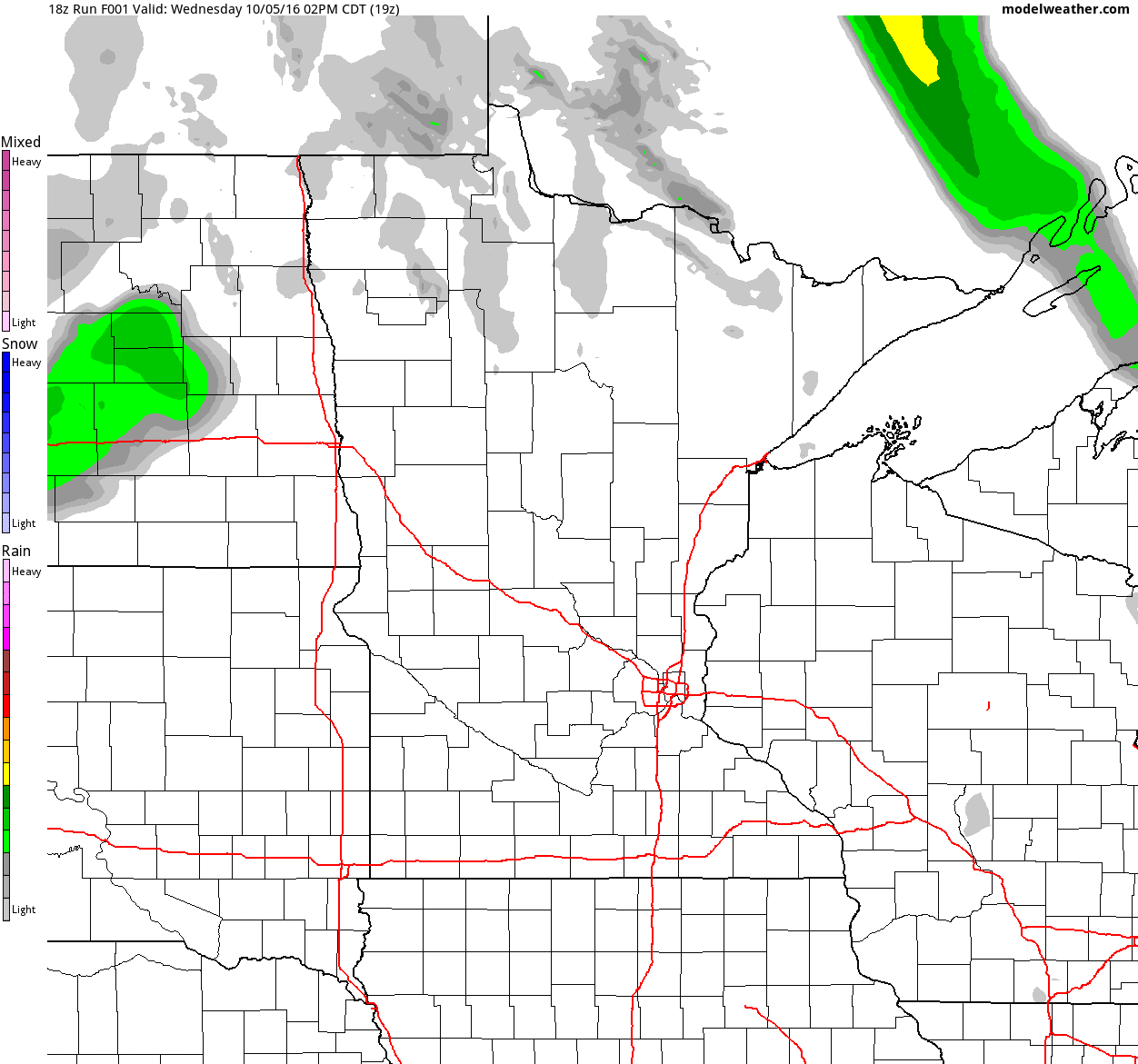
After a soggy start to the day Wednesday, we cleared out rapidly post cold front. Look at how sharp the clearing line was midday as it moved across northeast Minnesota and Wisconsin. This left the rest of the region under mostly sunny skies the rest of the day.
After battering Haiti, eastern Cuba and parts of the Bahamas with hurricane force winds and exceptional rainfall, Matthew is now on track to impact the Southeastern U.S. later this week and weekend. Latest forecasts have Matthew sustaining Major hurricane status (category 3 or higher) as it nears Florida by Friday.
Take a look at this video that Terry Virts @AstroTerry posted as he flew over Hurricane Matthew from aboard the International Space Station midweek.
See the video HERE
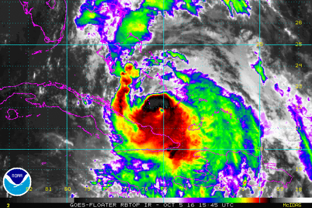
Images of Matthew
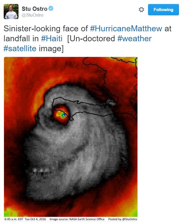
Here's an image of Hurricane Matthew that has been making the rounds on Twitter. This is a REAL infrared satellite image that was taken as Matthew was making landfall with Haiti early AM Tuesday. Kind of creepy, no?
___________________________________
Hurricane Watches and Warnings have been posted for parts of Florida and Georgia in advance of Matthew as it continues to slowly drift northwest toward the Peninsula. Latest forecast tracks take this along the east coast of Florida later this week/weekend ahead with significant impacts. Mandatory evacuations have already been order for parts of the state as Matthew threatens.
...HURRICANE WATCH IN EFFECT... THE NATIONAL WEATHER SERVICE IN MELBOURNE HAS ISSUED A HURRICANE WATCH.
* WINDS...AS MAJOR HURRICANE MATTHEW MOVES CLOSER...THE THREAT FOR SUSTAINED HIGH WINDS IS LIKELY TO INCREASE. THE LATEST FORECAST IS FOR STRONG TROPICAL FORCE WINDS FROM LATE WEDNESDAY OVERNIGHT OR EARLY THURSDAY MORNING. HURRICANE FORCE WINDS WILL BE POSSIBLE FROM LATE THURSDAY AFTERNOON INTO FRIDAY.
* WAVES/SEAS...SEAS WILL LIKELY BEGIN TO INCREASE AS EARLY AS WEDNESDAY AFTERNOON AND PEAK THURSDAY NIGHT AND FRIDAY TO 25 TO 30 FEET OFFSHORE. MARINERS ARE ADVISED TO RETURN TO PORT BY WEDNESDAY AFTERNOON AND MAKE ALL PREPARATIONS TO SECURE THEIR VESSELS.
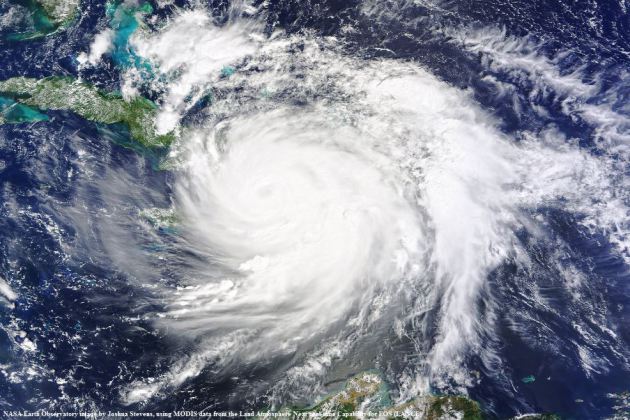
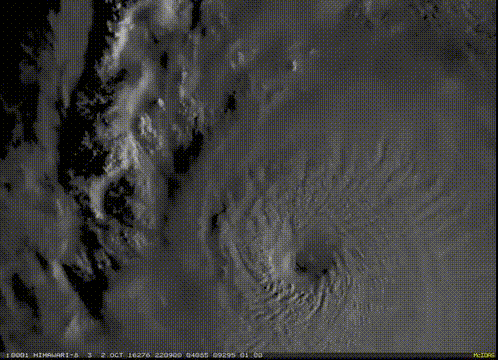
Hurricane Matthew
This was the view of Hurricane Matthew as of PM Wednesday, which showed it well north of Cuba and moving through the Bahamas. This northwest track will continue until it reaches the east coast of Florida. It is then forecast to make a more northerly turn by the weekend.
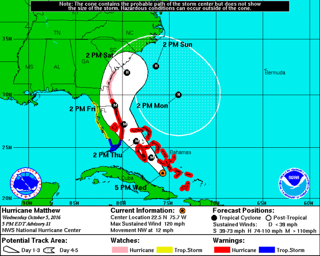
Tracking Matthew
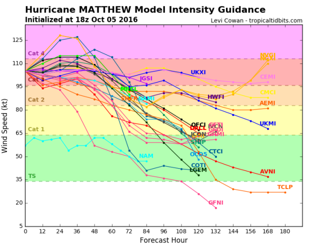
Here's the latest from the National Hurricane Center, which suggests Matthew will continue at major hurricane strength through the end of the week as it drifts over the Bahamas and slides along the east coast of Florida. This will be a dangerous storm system and bears watching as the forecast track could change.
Tracking Matthew
Here's the latest GFS and ECMWF track for Matthew by early Friday morning. Note that the storm looks to potentially take a very close track to the east coast of Florida. Interestingly, both models seem to be pretty close together at that point! This is a very disturbing signal as Matthew could be quite intense at this point.
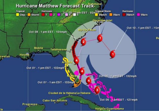
Tracking Matthew
Well, this is interesting. While some models take Matthew out to sea, some loop it back around into Florida by next week with a secondary heavy blow... stay tuned for latest forecasts.
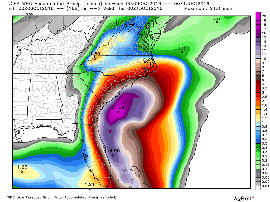
Heavy Rainfall Potential
With Matthew tracking a little farther west, heavy rainfall is now going to be a major issue across the East Coast. Note that some locations could see up to 6" to 10"+ with some significantly higher tallies possible along the coast.
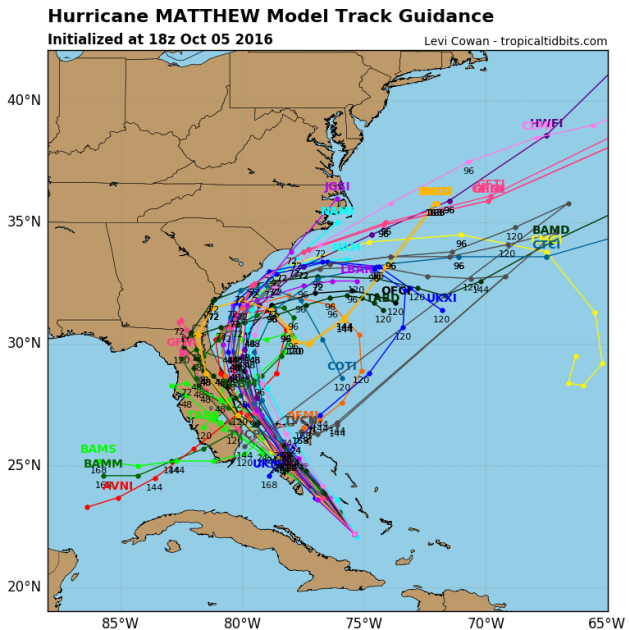
Tracking Matthew
After strengthening into a category 5 hurricane late last week (the first in the Atlantic basin since Felix in 2007; 9 years), models project that we may still see major hurricane strength (category 3 or higher) over the next few days.
________________________________________
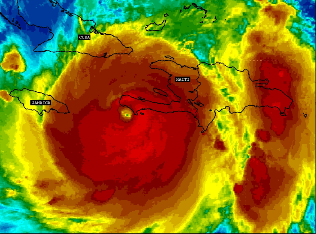
Hurricane Matthew became the 5th hurricane of the 2016 Atlantic hurricane season on Thursday of last week and strengthened rapidly into a MAJOR category 3 hurricane Friday morning. Overnight Friday, Matthew strengthened even more into a category 5 storm with sustained winds up to 160mph. Interestingly, Matthew became the first category 5 hurricane in the Atlantic Basin since Hurricane Felix in 2007. 7AM EDT Tuesday, Matthew made landfall in southwest Haiti as a strong category 4 storm with winds up to 145mph; this was the first category 4 hurricane to make landfall with Haiti since Cleo in 1964. The 2nd category 4 landfall occurred in eastern Cuba 8PM EDT Tuesday with winds of 140mph. This was the first category 4 land fall with Cuba since Ike in 2008! Interestingly, there have now been 15 category 4+ landfalls in recorded history, 7 of which have hit since 2001!
Matthew Made Two Category 4 Landfalls on Tuesday
Take a look at the loops below, which show Matthew making landfall in southwestern Haiti and eastern Cuba on Tuesday, both as a category 4 storm with sustained winds near 140mph! This brought significant weather impacts to these areas, not only strong winds, but extreme rainfall tallies as well.
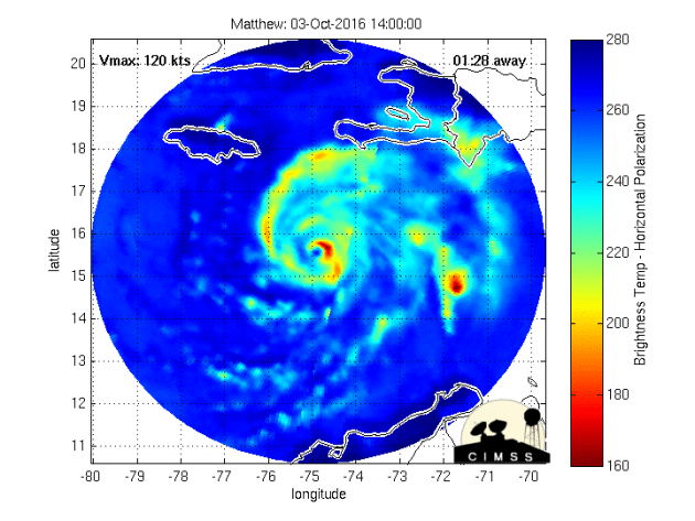
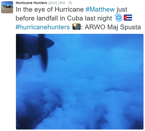
Radar Prior to Landfall with Haiti early AM Tuesday
Here's a look at the radar and an image from the Hurricane Hunter from inside the radar just prior to making landfall with southwestern Haiti early Tuesday morning. Note that the Hurricane Hunter estimated the eyewall to be nearly 14miles across at this point!
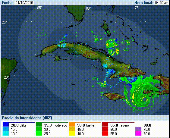
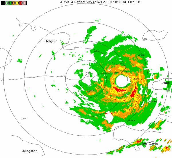
Radar Prior to Landfall PM Tuesday in Cuba
Here's another radar view and photo from inside the eye just prior to landfall with eastern Cuba late Tuesday.
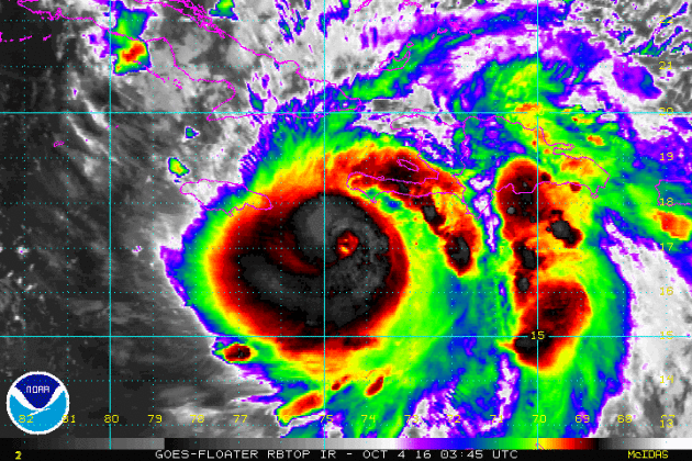
The Eye of Matthew
This is a high resolution visible satellite loop of Hurricane Matthew from late last week when it was near its peak intensity; high end category 4 to low end category 5 storm. What an impressive storm!
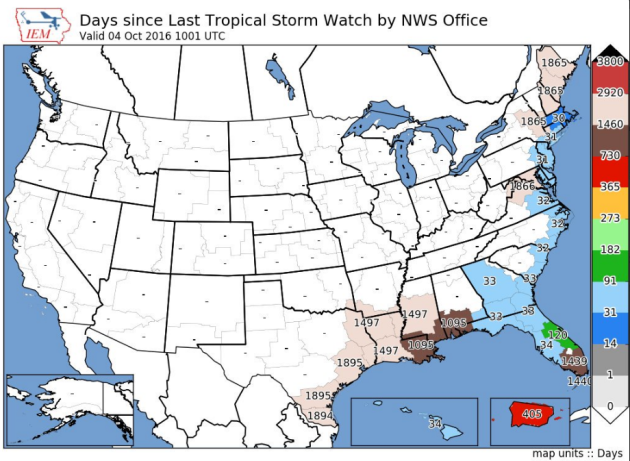
Days Since Late Tropical Watches
How about this stat! According to the @NWSKeyWest, prior to tropical watches being issued on Monday, it had been nearly 4 years since the last tropical storm watches had been issued for the Florida Keys!
____________________________________
Rapid Clearing Wednesday
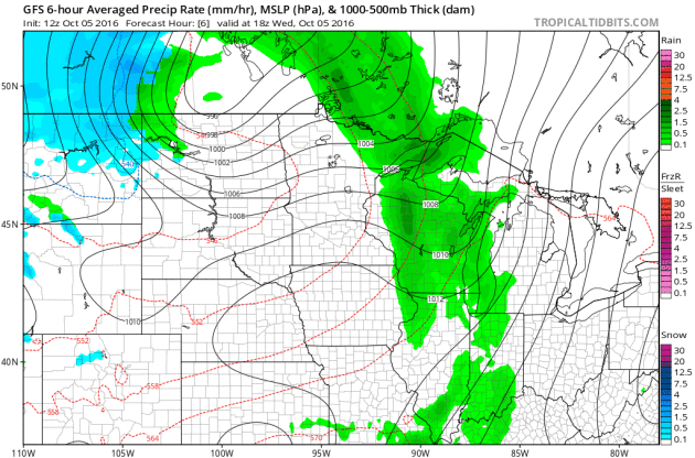
Another Surge of Rain PM Thursday/AM Friday
Heavy rain ended across the Minnesota early Tuesday morning, but another area of showers is expected to push through the region PM Thursday/AM Friday with additional rainfall tallies. In the wake of the secondary batch of rain PM Thursday, temperatures will drop through the end of the week and weekend ahead.
Turning Colder Late Week
Temperatures ahead of the cold front warmer into the 70s earlier this week, but note how much cooler it gets post front by the second half of the week. I wouldn't be surprised to see widespread frost and freeze headlines by the end of the week/weekend ahead.
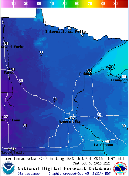
Frosty Friday Night Ahead - For Some
Take a look at the low temperatures expected across the state Friday night/AM Saturday. With lows dipping into the low to mid 30s, I could see widespread frost and freeze headlines posted later this week. Stay tuned!
_________________________________________
Signs of Fall Closer to Home
Signs of fall are starting to pop a little more each and every day. Things are a little more advanced across the central and northern part of the state, but we're getting there.

After a dry start Thursday, another surge of cold rain moves in Thursday night. Some models are even hinting at a few wet flakes mixing in across the international border early Friday morning. Yes, SNOW!
Meanwhile, Hurricane Warnings have been posted for parts of Florida in advance of Hurricane Matthew, which will impact the region later this week. Mandatory evacuation have already been issued for a number of locations as strong winds and flooding rains look to batter the Southeast through the weekend.
Extended forecasts are unclear. Some bring Matthew out to sea, while some circle it back into Florida for another heavy blow next week. Good grief!
___________________________________________________
1987: Snow falls over the Arrowhead region.
________________________________
Average High/Low for Minneapolis
October 6th
 _______________________________________________________________________
___________________________________________________________

...SUMMARY... SCATTERED SEVERE THUNDERSTORMS CAPABLE OF WIND...HAIL...AND ISOLATED TORNADOES ARE EXPECTED THURSDAY AFTERNOON AND EVENING ROUGHLY FROM EASTERN KANSAS INTO SOUTHWESTERN IOWA. LOCALIZED HAIL AND WIND IS ALSO POSSIBLE IN A MORE ISOLATED MANNER FROM CENTRAL OKLAHOMA INTO NORTHWEST TEXAS. ...SYNOPSIS... AN IMPRESSIVE SHORTWAVE TROUGH WILL MOVE ACROSS THE CNTRL AND NRN PLAINS ON THU WITH AN INTENSIFYING MID TO UPPER LEVEL SPEED MAX DEVELOPING LATE IN THE DAY FROM KS INTO THE UPPER MS VALLEY. AT THE SFC...LOW PRESSURE AHEAD OF A DEVELOPING COLD FRONT WILL MOVE FROM CNTRL KS AT 18Z INTO IA BY 00Z. PRECEDING THE LOW WILL BE A WARM FRONT WHICH WILL LIFT NWD INTO SERN NEB AND IA BY LATE AFTERNOON. TO THE S OF THESE BOUNDARIES...A MOIST AND UNSTABLE AIR MASS WILL DEVELOP WITH UPPER 60S F DEWPOINTS BENEATH COOL PROFILES ALOFT. THIS SHOULD RESULT IN A CONCENTRATED AREA OF SEVERE WEATHER BEGINNING DURING THE LATE AFTERNOON FROM ERN KS INTO IA. TO THE SW...OTHER SCATTERED STORMS WILL ALSO DEVELOP ALONG THE COLD FRONT FROM NRN OK INTO NWRN TX...BUT WITH A LESSER SEVERE WEATHER THREAT AS SHEAR PROFILES WILL NOT BE AS FAVORABLE AS POINTS N.

"Our kids are screwed thanks to climate change: scientist"
"The Earth is the hottest it’s been in 115,000 years, and it’s going to cost future generations trillions to effectively lower greenhouse gases, a top climate researcher warns in an alarming new report. Climate change is real and “we are running out of time,” according to former NASA climate scientist James Hansen, who is calling on President Obama and other world leaders to create a global tax on fossil fuel emissions. Hansen’s paper, titled “Young People’s Burden: Requirement of Negative CO2 Emissions,” has not yet been peer-reviewed but the outspoken climate researcher chose to release it on Tuesday to raise the alarm for future generations that will be forced to “clean up the mess.” Over the past 45 years, the heat has been rising at a rate of 0.18C per decade, explains the article in in Earth System Dynamics journal. The global temperature hasn’t been this steamy since the Eemian period during which the earth’s sea levels were 20 to 30 feet higher than they are today and there was much less ice than there is now."
See more from NYPost HERE:

__________________________________________________________________"Climate change could be a boon for crayfish and other freshwater creatures"
"British rivers could be set for an explosion of crayfish and other crustaceans as global warming pushes up inland water temperatures, new research predicts. While similar sea-based species are set to suffer from climate change, their freshwater counterparts are likely to benefit from a warmer habitat. Previous research involving land-based vertebrae has found that the diversity of a species tends to increase with warming and that this is a general trend across habitats."
See more from Telegraph.co.uk HERE:

____________________________________________________________

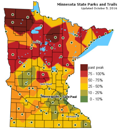
Fall Color Update
The latest update from the MN DNR shows that we are well on our way in the fall color department with several areas up north seeing peak colors (75% - 100%). There are even pockets of past peak colors across north-central and northwestern Minnesota near Scenic and Lake Bronson State Parks. Note that much of the Twin Cities is only 10% to 25% color, but is turning quickly! By the way, the average peak there is generally late September to mid October.
_______________________________________________
Cold Rain late - Florida Braces for Matthew
We've turned a meteorological corner here across the Upper Midwest. You can feel it in the air. Sure, we might be able to flirt with a few more warm days this fall, but there's a definite change.
Fall color is popping at an alarming rate and raking duties are getting underway. Don't blink, leaves will be off trees soon as they get ready to slumber through another long Minnesota winter.After a dry start Thursday, another surge of cold rain moves in Thursday night. Some models are even hinting at a few wet flakes mixing in across the international border early Friday morning. Yes, SNOW!
Meanwhile, Hurricane Warnings have been posted for parts of Florida in advance of Hurricane Matthew, which will impact the region later this week. Mandatory evacuation have already been issued for a number of locations as strong winds and flooding rains look to batter the Southeast through the weekend.
Extended forecasts are unclear. Some bring Matthew out to sea, while some circle it back into Florida for another heavy blow next week. Good grief!
___________________________________________________
Extended Weather Outlook
WEDNESDAY NIGHT: Partly cloudy and cooler. Winds: SSW 5-10. Low: 47
THURSDAY: Dry start, cold rain late. Winds: NNW 5-10. High: 64.
THURSDAY NIGHT: Scattered showers, possibly a rumble of thunder. Winds: N 5-10. Low: 40
FRIDAY: A nippy wind. A few AM flakes up north? Frosty overnight. Winds: W 10-15. High: 54.
SATURDAY: Some frost in the burbs. Chilled sun. Winds: WNW 5-10. Wake-up: 37. High: 55.
SUNDAY: Some crisp sunshine. Winds: SE 5-10. Wake-up: 39. High: 62.
MONDAY: Clouds increase. A few PM showers?. Winds: SW 5-15. Wake-up: 48. High: 67.
TUESDAY: Filtered sunshine. Average. Winds: NE 5-10. Wake-up: 49. High: 65.
WEDNESDAY: Passing clouds. Brief shower? Winds: SSE 5-10. Wake-up: 51. High: 67.
_______________________________
_______________________________
This Day in Weather History
October 6th
1997: Hail, wind, and an F0 tornado are reported in the early morning hours in several counties in west central Minnesota. Near Canby in Yellow Medicine County, hail combined with wind gusts nearing 60 mph damage the roof of a bus garage, elementary school windows and a school vehicle. Renville, McLeod, Carver, Scott, and Dakota counties also receive hail and strong winds. Widespread pea to marble size hail accumulates to three inches deep in several areas, and crops are severely damaged over a large part of Renville county. Many power lines and trees are blown down. Southeast of Bird Island, a barn collapses and kills over 100 pigs. Near Brownton in McLeod County, hail accumulates to a depth of 3 inches with one foot drifts. A brief tornado touches down near Stewart in McLeod County, damaging a few trees.October 6th
1987: Snow falls over the Arrowhead region.
________________________________
Average High/Low for Minneapolis
October 6th
Average High: 63F (Record: 87F set in 2007)
Average Low: 43F (Record: 25F set in 1873)
_________________________________
Average Low: 43F (Record: 25F set in 1873)
_________________________________
Sunrise/Sunset Times for Minneapolis
October 6th
October 6th
Sunrise: 7:18am
Sunset: 6:43pm
Sunset: 6:43pm
*Daylight Lost Since Yesterday: ~3mins & 5sec
*Daylight Lost Since Summer Solstice: ~4hours and 11mins
______________________________________________________________________
*Daylight Lost Since Summer Solstice: ~4hours and 11mins
______________________________________________________________________
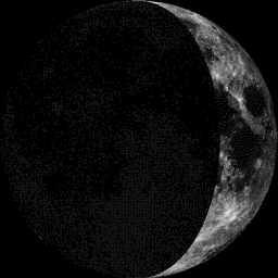
Moon Phase for October 6th at Midnight
1.9 Days Before First Quarter
1.9 Days Before First Quarter
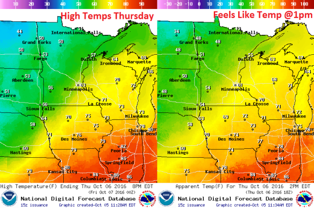
Weather Outlook Thursday
High temperatures on Wednesday will start cooling down post front. Note that readings will still be close to 70F across the southern part of the state, but note the much cooler air lurking across northern Minnesota with highs only in the 50s!
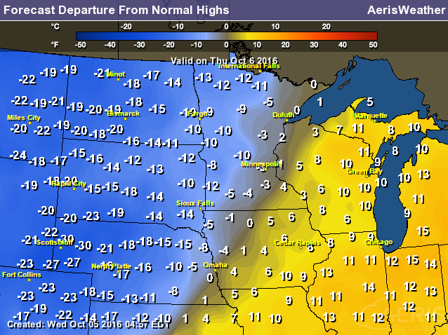
High Temperatures From Average Thursday
Weather Outlook Thursday
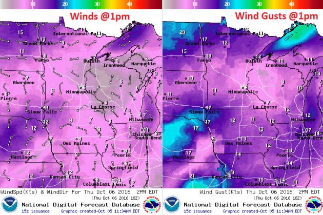
Winds on Wednesday won't be quite as strong as they were on Tuesday, however, it'll still be breezy. Winds will turn out of a more westerly direction, which will be a bit of a cooler wind and with wind gusts approaching 25mph+ across the northwestern part of the state, it'll fee even cooler there.
Weather Outlook Thursday
After heavy rainfall overnight Tuesday/early Wednesday, it looks like we clear out pretty decently on Wednesday just behind the cold front. Enjoy it because clouds and rain return on Thursday with MUCH cooler temperatures later this week.
___________________________________________________________
Simulated Radar
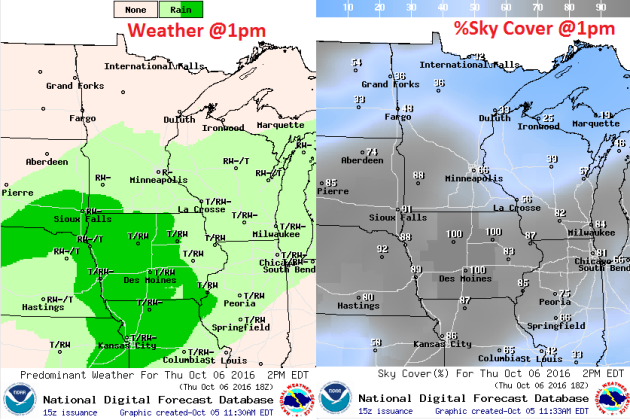
The simulated radar from Wednesday to Saturday shows quiet conditions on Wednesday turning to unsettled conditions PM Tuesday to AM Friday. Note the lingering precipitation along the international border. Some of this could be in the form a few wet snowflakes along the border.
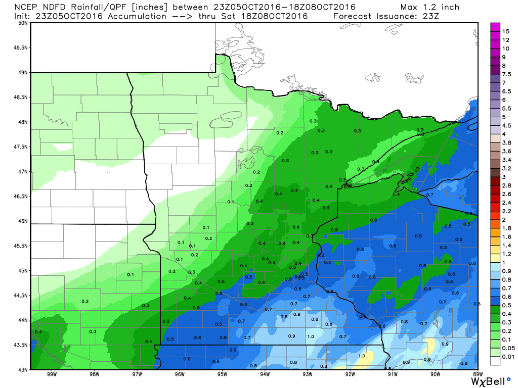
Rainfall Potential
Rainfall potential through Saturday suggests another round of showers moving in on Thursday. This batch looks a little lighter than what we had on PM Tuesday/AM Wednesday, but some could still see up to 0.5" or more, especially across the southeastern part of the state where a few thundershowers can't be ruled out.
_________________________________________
Extended Weather Outlook
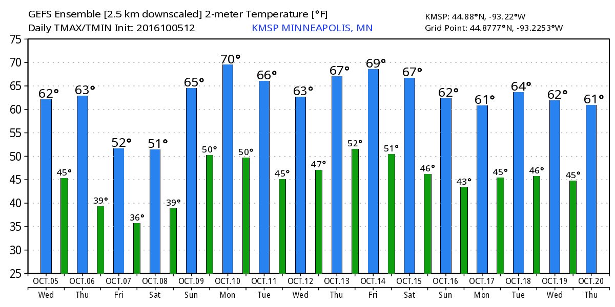
The extended temperature outlook over the next 16 days suggests moving in through second half of the week. High temperatures by Friday will dip into the 50s with overnight lows in the 30s. Some spots across the state will likely be dealing with frost and freeze conditions by then.
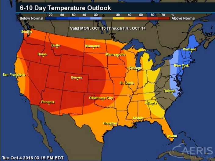
Warm Temperatures Return to Midwest
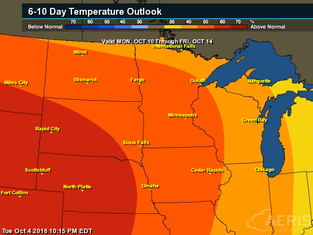
6 to 10 Day Temp Outlook
Here's the national temperature outlook from October10th - 14th, which shows warmer than average conditions across the western half of the nation after much below average temperatures and snowfall this week.
__________________________________________
National Weather Outlook
The same storm system that produced heavier snowfall across the high elevations across the Intermountain West will move east through the end of the week along with its colder air. Another surge of moisture will push through the Upper Midwest PM Thursday/AM Friday with a few rumbles of thunder and some isolated strong to severe storms across the Central U.S.. Note Hurricane Matthew moving into Florida and the Southeast with major impacts there.
Severe Threat Thursday
...SUMMARY... SCATTERED SEVERE THUNDERSTORMS CAPABLE OF WIND...HAIL...AND ISOLATED TORNADOES ARE EXPECTED THURSDAY AFTERNOON AND EVENING ROUGHLY FROM EASTERN KANSAS INTO SOUTHWESTERN IOWA. LOCALIZED HAIL AND WIND IS ALSO POSSIBLE IN A MORE ISOLATED MANNER FROM CENTRAL OKLAHOMA INTO NORTHWEST TEXAS. ...SYNOPSIS... AN IMPRESSIVE SHORTWAVE TROUGH WILL MOVE ACROSS THE CNTRL AND NRN PLAINS ON THU WITH AN INTENSIFYING MID TO UPPER LEVEL SPEED MAX DEVELOPING LATE IN THE DAY FROM KS INTO THE UPPER MS VALLEY. AT THE SFC...LOW PRESSURE AHEAD OF A DEVELOPING COLD FRONT WILL MOVE FROM CNTRL KS AT 18Z INTO IA BY 00Z. PRECEDING THE LOW WILL BE A WARM FRONT WHICH WILL LIFT NWD INTO SERN NEB AND IA BY LATE AFTERNOON. TO THE S OF THESE BOUNDARIES...A MOIST AND UNSTABLE AIR MASS WILL DEVELOP WITH UPPER 60S F DEWPOINTS BENEATH COOL PROFILES ALOFT. THIS SHOULD RESULT IN A CONCENTRATED AREA OF SEVERE WEATHER BEGINNING DURING THE LATE AFTERNOON FROM ERN KS INTO IA. TO THE SW...OTHER SCATTERED STORMS WILL ALSO DEVELOP ALONG THE COLD FRONT FROM NRN OK INTO NWRN TX...BUT WITH A LESSER SEVERE WEATHER THREAT AS SHEAR PROFILES WILL NOT BE AS FAVORABLE AS POINTS N.
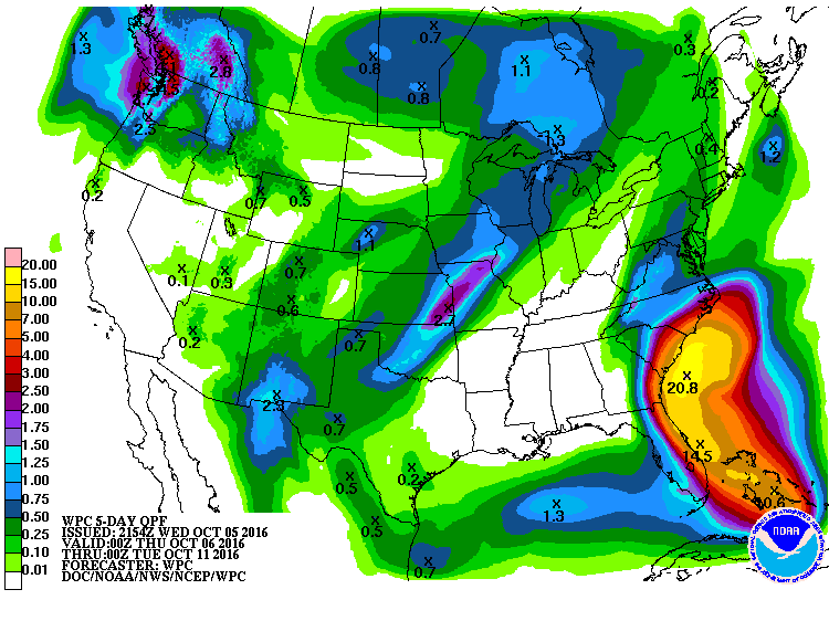
Precipitation Outlook
The heaviest rainfall over the next few days will be associated will Matthew in the Southeast, especially along the coast. Some spots could see 6" to 10"+, which could lead to major flooding.
___________________________________________
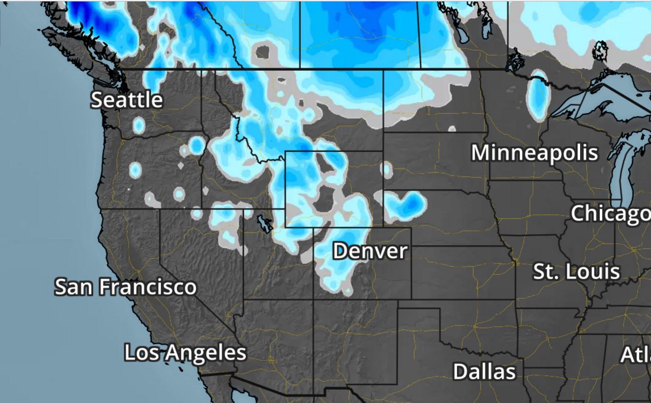
Snowfall Potential
Snowfall will linger across the Intermountain West as cold air and moisture linger there. However, note that there may be some light accumulations across the High Plains and the Dakotas through late week.
__________________________________________________________________"Our kids are screwed thanks to climate change: scientist"
"The Earth is the hottest it’s been in 115,000 years, and it’s going to cost future generations trillions to effectively lower greenhouse gases, a top climate researcher warns in an alarming new report. Climate change is real and “we are running out of time,” according to former NASA climate scientist James Hansen, who is calling on President Obama and other world leaders to create a global tax on fossil fuel emissions. Hansen’s paper, titled “Young People’s Burden: Requirement of Negative CO2 Emissions,” has not yet been peer-reviewed but the outspoken climate researcher chose to release it on Tuesday to raise the alarm for future generations that will be forced to “clean up the mess.” Over the past 45 years, the heat has been rising at a rate of 0.18C per decade, explains the article in in Earth System Dynamics journal. The global temperature hasn’t been this steamy since the Eemian period during which the earth’s sea levels were 20 to 30 feet higher than they are today and there was much less ice than there is now."
See more from NYPost HERE:
__________________________________________________________________"Climate change could be a boon for crayfish and other freshwater creatures"
"British rivers could be set for an explosion of crayfish and other crustaceans as global warming pushes up inland water temperatures, new research predicts. While similar sea-based species are set to suffer from climate change, their freshwater counterparts are likely to benefit from a warmer habitat. Previous research involving land-based vertebrae has found that the diversity of a species tends to increase with warming and that this is a general trend across habitats."
See more from Telegraph.co.uk HERE:
____________________________________________________________
Thanks for checking in and don't forget to follow me on Twitter @TNelsonWX
No comments:
Post a Comment