Twin Cities Climate Stat Pack From November 6th (through 7 PM)
High Sunday: 70
Low Sunday Morning: 46
Precipitation: 0.00"
Rainfall since January 1st: 35.20" (+7.16" from average)
Snowfall: 0"
Snowfall since September 1st: 0" (-1.6" from average)
Cities that saw records tied/fall Sunday:
- Duluth: 70 (previous record 66 in 1916)
- International Falls: 71 (previous record: 65 in 1975)
- Fargo, ND: 73 (previous record: 70 in 1887)
- Grand Forks, ND: 72 (previous record: 68 in 1975)
- Eau Claire, WI: 70 (tied record previously set in 1916 and 1895)
- La Crosse, WI: 71 (ties previous record set in 2001 and 1916)
Latest First 32 Degree Reading On Record
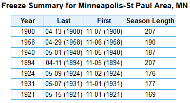
______________________________
Most Consecutive Days Above Freezing
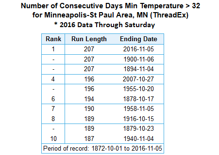
______________________________
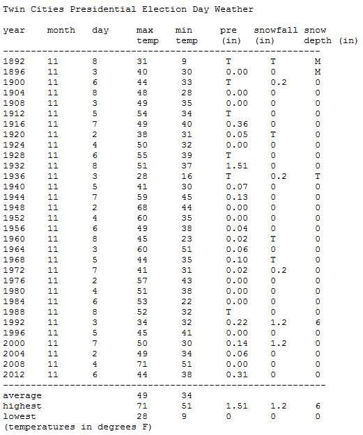
Twin Cities Election Day Weather
Tuesday is Election Day! The Minnesota Climatology Office
put together some past Presidential Election Day Weather for the Twin
Cities. The warmest was back in 2008 with a high of 71. Highs this year
will be in the mid 50s with mainly sunny skies. Here's a quick look at
past Presidential Election Day Weather for the Twin Cities:
______________________________
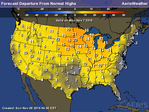
Record Breaking Stretch Of Weather ContinuesBy D.J. Kayser, filling in for Paul Douglas
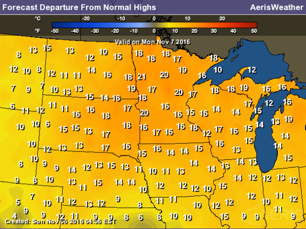
While the calendar may say November 7th, it certainly hasn't felt like it recently across the Twin Cities. Highs have topped 10-20 degrees above average for this time of year, and we haven't even dropped below 36 for a low so far this autumn. We set some record highs across the state over the weekend, and another record that has stood for the past 116 years in the Twin Cities will be tied today.
Back on this date in 1900 marks the latest first freeze in history as the temperature finally dropped to 32 or below that fall. That year also tied the longest stretch on record of 207 days where the temperature hadn't dropped to 32 or below. We've already broken that record, as the temperature at the Twin Cities Airport hasn't dropped to freezing since April 12th - 209 days ago including today.
As we look out into the future, there is the potential we could come close to freezing next weekend as cold air filters south behind a cold front. Until then, temperatures will continue to remain above average for this time of year.
______________________________
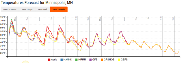
Extended Forecast for Minneapolis
MONDAY: Slight PM sprinkle chance. Mainly cloudy. High 62. Low 43. Chance of precipitation 10%. Wind S 5-10 mph.
TUESDAY: No weather concerns for Election Day. Sunny skies. High 55. Low 37. Chance of precipitation 0%. Wind NW 5-10 mph.
WEDNESDAY: Warmer weather returns. Mainly sunny. High 63. Low 43. Chance of precipitation 0%. Wind SW 3-7 mph.
THURSDAY: Passing dry cool front late in the day. Continued sunny. High 65. Low 40. Chance of precipitation 0%. Wind SW 5-10.
FRIDAY: Cool and windy Veterans Day. High 49. Low 34. Chance of precipitation 10%. Wind N 8-13 mph.
SATURDAY: Mix of clouds and sun. High 49. Low 33. Chance of precipitation 0%. Wind NE 3-7 mph.
SUNDAY: A touch warmer with sunshine. High 51. Low 33. Chance of precipitation 0%. Wind SW 8-13 mph.
______________________________
This Day in Weather History
November 7th
1844: A large prairie fire at Fort Snelling occurs, followed by more fires later on in the weekNovember 7th
______________________________
Average Temperatures & Precipitation for Minneapolis
November 7th
November 7th
Average High: 46F (Record: 72F set in 1874)
Average Low: 31F (Record: -6F set in 1991)
Average Precipitation: 0.06" (Record: 1.67" set in 1915)
Average Snow: 0.2" (Record: 4.2" in 1947)
______________________________
Average Low: 31F (Record: -6F set in 1991)
Average Precipitation: 0.06" (Record: 1.67" set in 1915)
Average Snow: 0.2" (Record: 4.2" in 1947)
______________________________
Sunrise/Sunset Times for Minneapolis
November 7th
Sunrise: 7:01 AMNovember 7th
Sunset: 4:53 PM
*Length Of Day: 9 hours, 52 minutes and 02 seconds
*Daylight Lost Since Yesterday: ~2 minutes and 37 seconds
*Next Sunrise That Is After 7:30 AM: December 1st (7:32 am)
*Earliest Sunset Of The Year: December 9th (4:31 pm)
______________________________
Minnesota Weather Outlook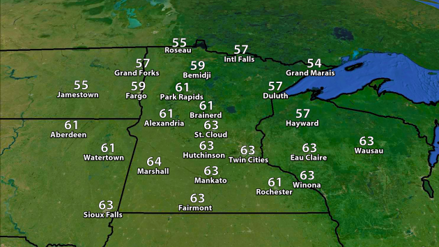
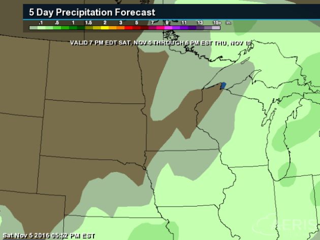
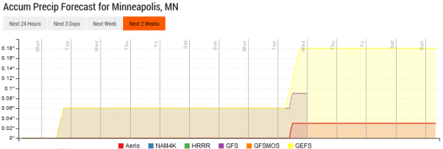
Looking
out at the precipitation forecast, there might be a better chance of
some rain as we head toward next Tuesday (the 15th). That would come
with another cool front, helping knock back temperatures once again.
______________________________
National Weather Stories
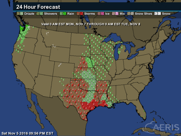
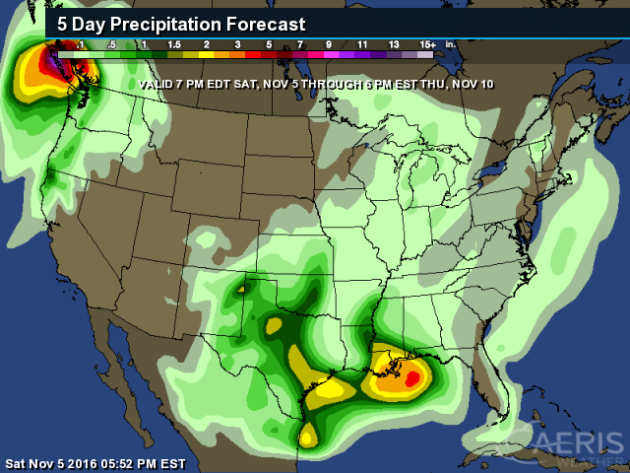
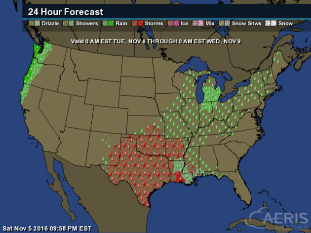
Rain
will be likely Monday once again across the Pacific Northwest.
Meanwhile, showers will be possible across the mid-section of the
country, with storms from Nebraska to the Mexico border.
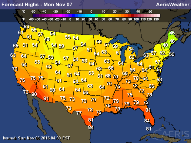
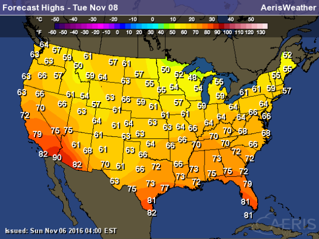
The
coolest highs across the nation Monday will be in northern New England,
with highs only in the 40s. The warmest temperatures will be seen
across the Southwest, with highs in the low 90s in spots.
Election Day Forecast
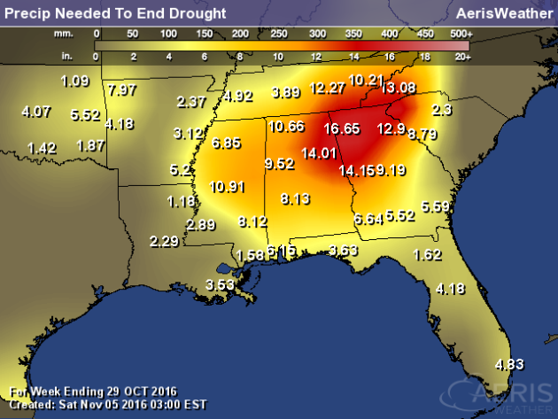
Southeast Drought Continues
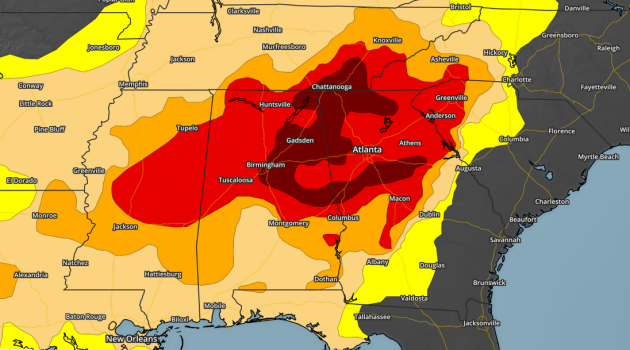
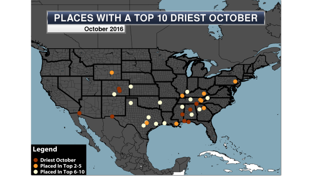
- Birmingham, AL – 0.00″ (driest October on record)
- Colorado Springs, CO – 0.00″ (driest October on record)
- El Paso, TX – 0.00″ (driest October on record)
- Mobile, AL – 0.00″ (driest October on record) – only the second overall month on record with no precipitation falling
- Pensacola, FL – 0.00″ (driest October on record)
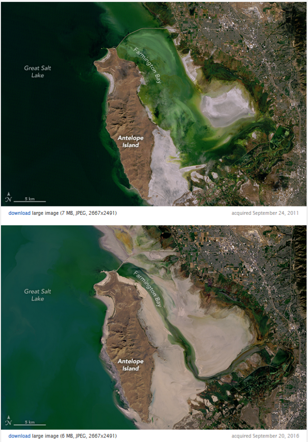
The Great Salt Lake Is Drying Up
______________________________
Thanks for checking in and have a great Monday! Don't forget to follow me on Twitter (@dkayserwx) and like me on Facebook (Meteorologist D.J. Kayser)!
- D.J. Kayser

No comments:
Post a Comment