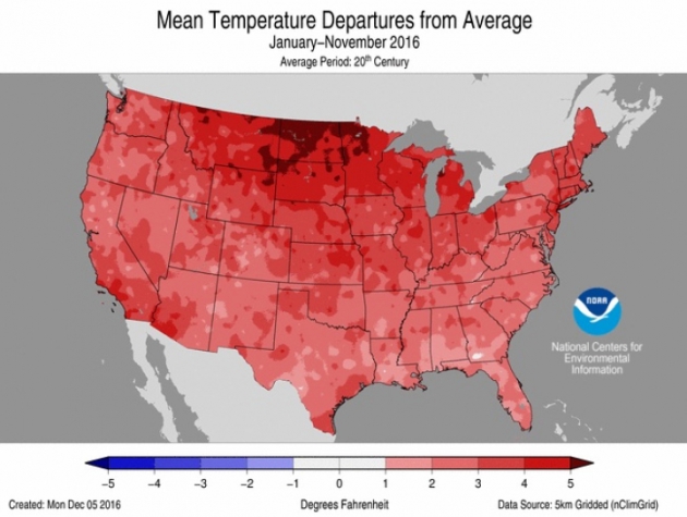
"Record-Warm Autumn Solidifies 2nd-Hottest Year for U.S."
The numbers are in from NOAA and after a record-warm autumn for the contiguous U.S., we should have no problem setting the 2nd-hottest year on record for the U.S.. Take a look at the excerpt below, I've highlighted a few notable stats from the Climate Central article:
It's almost certain that 2016 will be the second-hottest year on record for the contiguous U.S., with new data showing that November was the second warmest on record for the Lower 48, capping off a record-hot autumn (for the second year in a row). Through November, 2016 as a whole has been the second hottest in 122 years of record keeping, the National Oceanic and Atmospheric Administration announced Wednesday, and now there’s only one month to go. "Even if December were one of the 20 coldest on record, the average temperature in 2016 for the CONUS would still be second warmest,” Chris Fenimore, a physical scientist with NOAA’s National Center for Environmental Information, said in an email. Alaska, meanwhile, continues to see its hottest year by a large margin. All of these temperature records are in line with the broader warming of the planet caused by heat-trapping greenhouse gases that will also help 2016 easily beat out 2015 as the hottest year on record globally.
See more from Climate Central HERE:
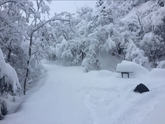
 Heavy Snow in Juneau, Alaska
Thanks to the National Weather Service in Juneau, AK for the picture below, which shows a fairly good dumping of snow. As of midday Wednesday, there was nearly a foot of snow on the ground at the NWS office there!
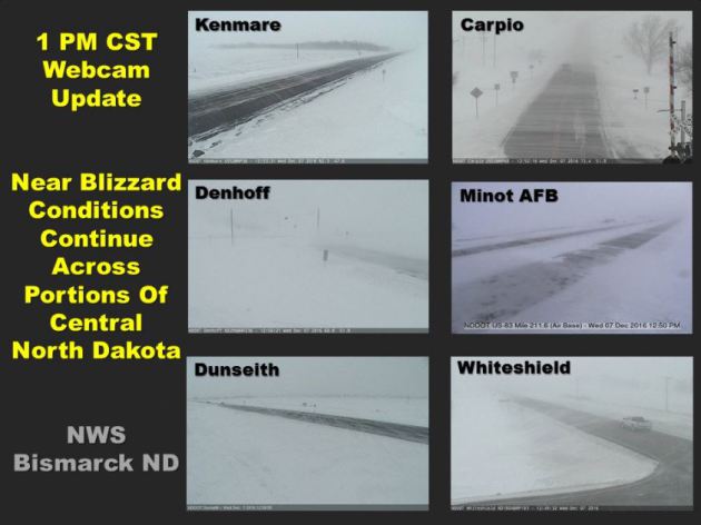
 Blowing Snow & Ground Blizzard Conditions in North Dakota
Thanks to the NWS out of Bismarck, ND for the tweet below from midday Wednesday. This is what the webcams looked like across parts of the state as strong, gusty winds created continued blowing snow and ground blizzard conditions
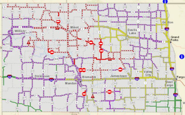
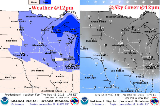
 North Dakota Road Conditions
Road conditions across much of North Dakota were still very poor on Wednesday. Note the red colored roads, which indicate either Closed or no travel advised. Much of the rest of the state reported difficult driving conditions due to snow or ice covered roads.
North Dakota Road Conditions
Road conditions across much of North Dakota were still very poor on Wednesday. Note the red colored roads, which indicate either Closed or no travel advised. Much of the rest of the state reported difficult driving conditions due to snow or ice covered roads.
 ____________________________________________________________________________
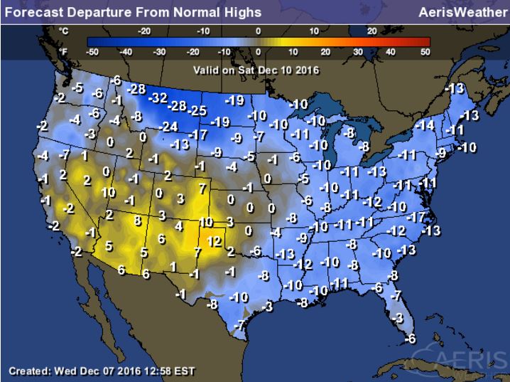
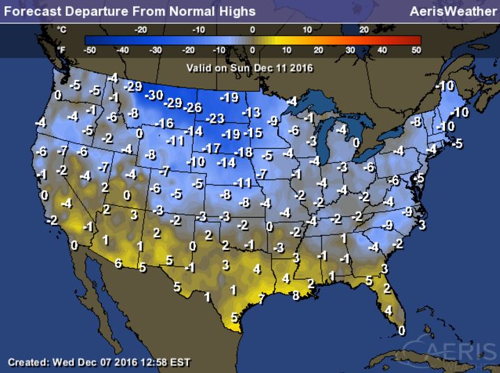
Here's that blob of Arctic as it continues to spread through the eastern half of the country through the rest of the week. Many locations will dip to near 10F to 20F+ below average levels, which will likely be some of the coldest air of the season.
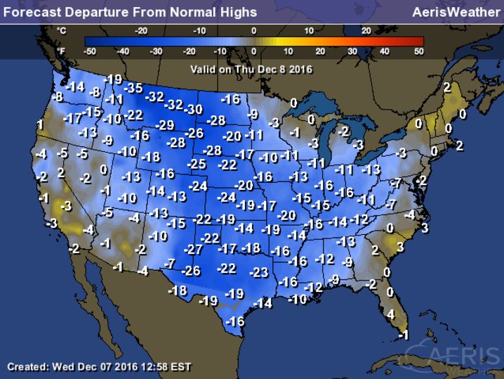
 High Temperatures From Average From Thursday through Sunday
__________________________________________________________________
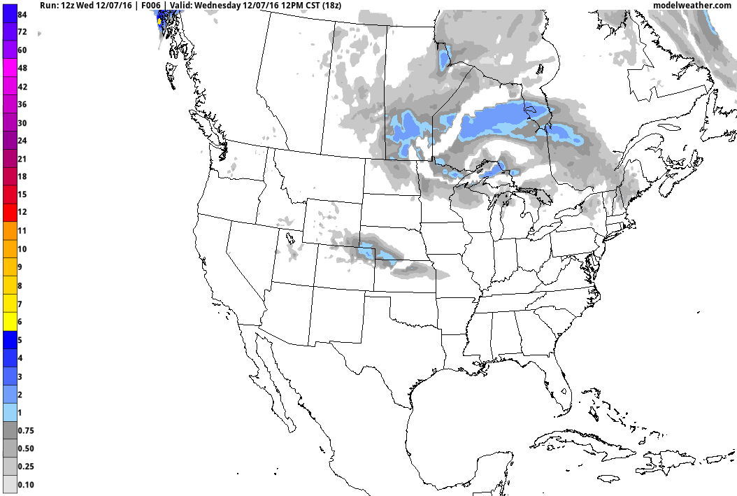
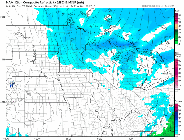
84-Hour Outlook
Here's the national weather outlook through Saturday, which shows heavy lake effect snow developing across the Great Lakes Region through the end of the week. The next surge of Pacific moisture begins to slide into the Western US with heavy rain along the coast and heavy snow in the high elevations. The next wave of energy will develop into a snow maker across the Upper Midwest and the Great Lakes by the weekend.
.gif)
The numbers are in from NOAA and after a record-warm autumn for the contiguous U.S., we should have no problem setting the 2nd-hottest year on record for the U.S.. Take a look at the excerpt below, I've highlighted a few notable stats from the Climate Central article:
It's almost certain that 2016 will be the second-hottest year on record for the contiguous U.S., with new data showing that November was the second warmest on record for the Lower 48, capping off a record-hot autumn (for the second year in a row). Through November, 2016 as a whole has been the second hottest in 122 years of record keeping, the National Oceanic and Atmospheric Administration announced Wednesday, and now there’s only one month to go. "Even if December were one of the 20 coldest on record, the average temperature in 2016 for the CONUS would still be second warmest,” Chris Fenimore, a physical scientist with NOAA’s National Center for Environmental Information, said in an email. Alaska, meanwhile, continues to see its hottest year by a large margin. All of these temperature records are in line with the broader warming of the planet caused by heat-trapping greenhouse gases that will also help 2016 easily beat out 2015 as the hottest year on record globally.
See more from Climate Central HERE:
Thanks to the National Weather Service in Juneau, AK for the picture below, which shows a fairly good dumping of snow. As of midday Wednesday, there was nearly a foot of snow on the ground at the NWS office there!
Thanks to the NWS out of Bismarck, ND for the tweet below from midday Wednesday. This is what the webcams looked like across parts of the state as strong, gusty winds created continued blowing snow and ground blizzard conditions
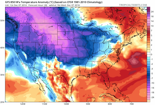
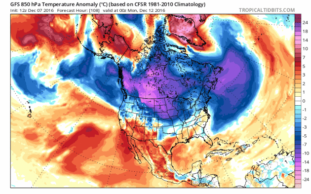
Arctic Air Plunges into the Lower 48
The image below shows the temperature anomaly from Wednesday, December 7th and note the bright purple from Alaska into the northwestern part of the US. This denotes MUCH cooler than average temperatures. This is the chunk of Arctic air that will continue to surge south into the Lower 48 through the rest of the week. The cold blast will be felt in the Eastern US by the end of the week.
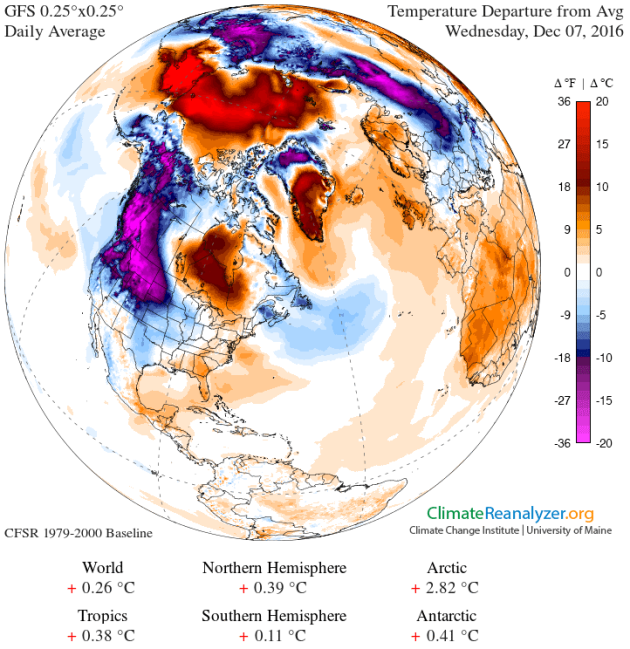
Arctic Air Surges SouthThe image below shows the temperature anomaly from Wednesday, December 7th and note the bright purple from Alaska into the northwestern part of the US. This denotes MUCH cooler than average temperatures. This is the chunk of Arctic air that will continue to surge south into the Lower 48 through the rest of the week. The cold blast will be felt in the Eastern US by the end of the week.
Here's that blob of Arctic as it continues to spread through the eastern half of the country through the rest of the week. Many locations will dip to near 10F to 20F+ below average levels, which will likely be some of the coldest air of the season.
Here's a look at high temperatures from average across the nation Thursday through Sunday and note that many locations will be nearly 10F to 20F colder than average! Some spots along the Front Range of the Rockies could be nearly 30F below average then... BRR!
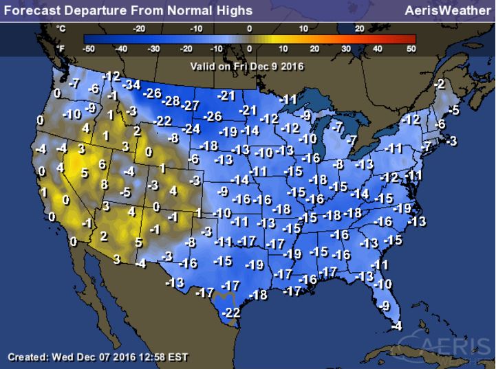
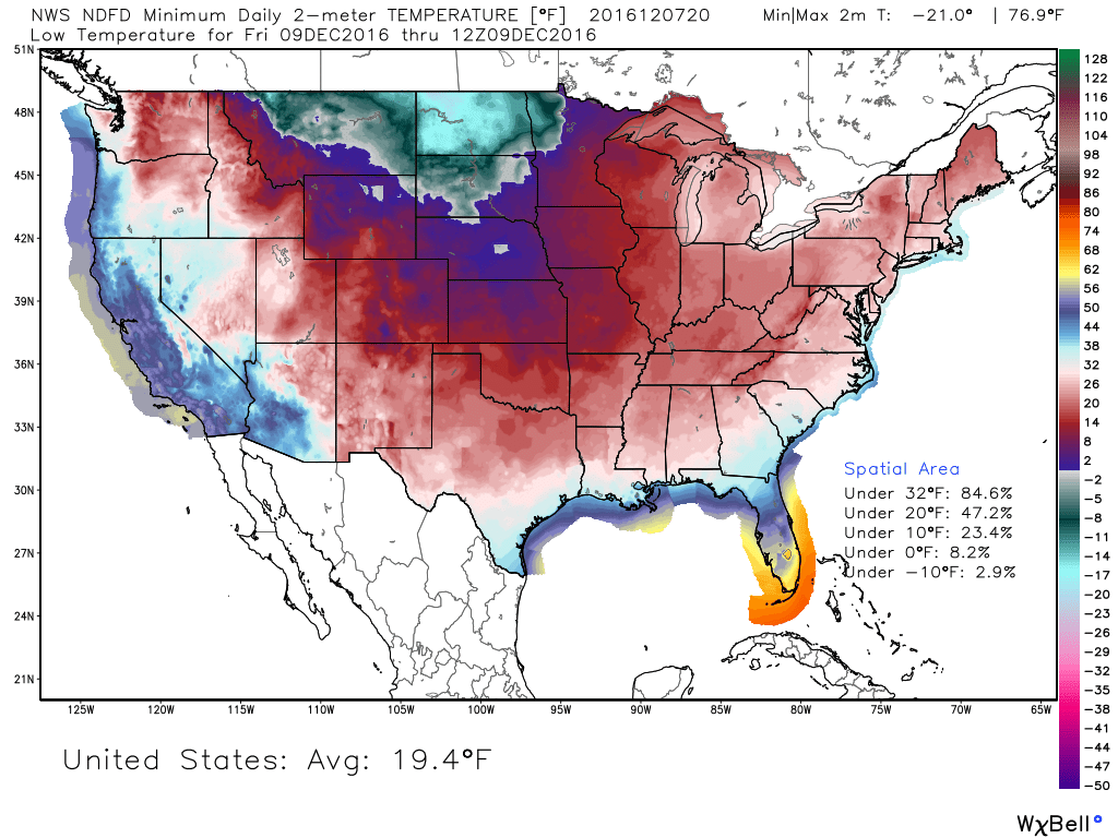
Much of the Nation Below Freezing Friday Morning
Friday morning appears to be the most widespread (cold) morning of the week with nearly 85% of the nation seeing low temperatures below freezing! The coldest air will be found in the High Plains where some spots across North Dakota could drop into the teens below zero! Wind chills there could be in the 20s below zero by Friday morning too!
_________________________________________________________________________
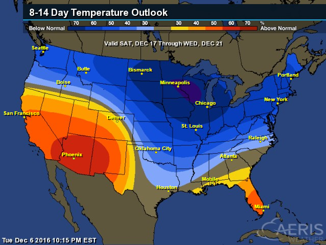
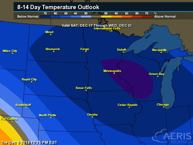
8 to 14 Day Temperature Outlook
According to NOAA's Climate Prediction Center, the 8 to 14 day temperature outlook suggests that colder than average temperatures will be with much of us in northern tier of the nation and across much of the eastern half of the country. The coldest of which will be found across the Upper Midwest and Great Lakes Region. With that said, look for several bouts of lake effect snow over the next couple weeks.
Another Surge of Arctic Air Next
Another surge of Arctic air will blow into the Lower 48 as we head into next week. Take a look at the bright purple blob surging south of the international border from Monday, December 12th to Friday, December 16th. For some across the Upper Midwest, Great Lakes and even into the Northeast, this will be the coldest air of the season thus far.
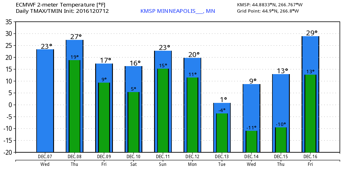
Extended Outlook for Minneapolis, MN
Take a look at the extended outlook for Minneapolis, MN, which shows colder temperatures through the upcoming weekend, but another surge of even colder air will be moving in by the early/middle part of next week. High temperatures will likely dip into the single digits with overnight lows in the teens below zero!
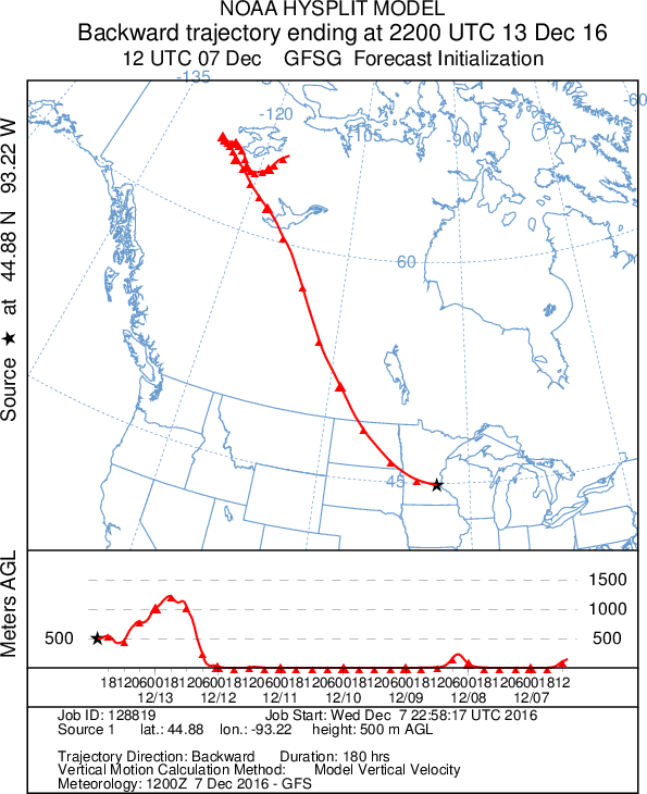
Backwards Trajectory Model
Here's an interesting look at the backwards trajectory of the airmass that will be in place by Tuesday of next week. Note that the origin of the airmass comes right out of Arctic region. If you think it's cold now in Minnesota. Wait till next week!
__________________________________________________________________
Here's the national weather outlook through Saturday, which shows heavy lake effect snow developing across the Great Lakes Region through the end of the week. The next surge of Pacific moisture begins to slide into the Western US with heavy rain along the coast and heavy snow in the high elevations. The next wave of energy will develop into a snow maker across the Upper Midwest and the Great Lakes by the weekend.
10-Day Snowfall Outlook
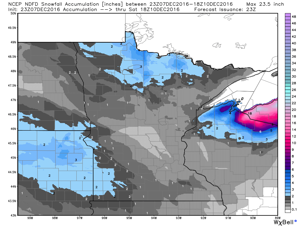
Here's the 10 day snowfall potential, which initially shows heavier snow ongoing across the Upper Midwest and translating into heavier lake effect snow across the Great Lakes Region. The next surge of Pacific moisture will bring heavy snow to the high elevation. As this next surge of Pacific moisture moves inland, it appears that some across the Midwest may be in for some additional accumulating snow by the weekend.
Here's the 10 day snowfall potential, which initially shows heavier snow ongoing across the Upper Midwest and translating into heavier lake effect snow across the Great Lakes Region. The next surge of Pacific moisture will bring heavy snow to the high elevation. As this next surge of Pacific moisture moves inland, it appears that some across the Midwest may be in for some additional accumulating snow by the weekend.
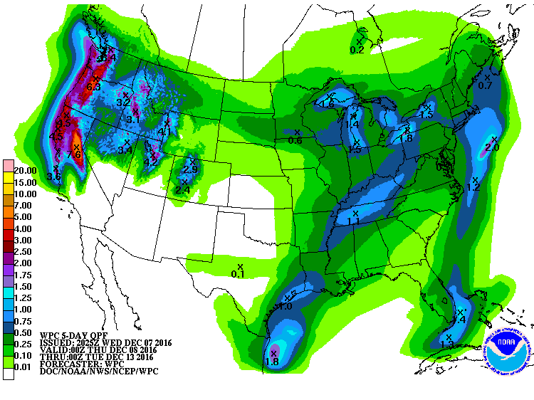
5 Day Precipitation Outlook
According to NOAA's WPC, the 5 day precipitation outlook suggests heavy precipitation in the Western US, especially along the coast in the higher elevations. Some spots could see as much as 3" to 7"+ liquid through early next week. Also note the heavy moisture around the Great Lakes, which will fall in the form of heavy lake effect snow over the next several days! There will also be some fairly decent tallies across parts of the Tennessee Valley and into Kentucky, which will further help the drought.
______________________________________________________________________________
Ahh, now that's more like it! Single-digit wind chills and wind- whipped snowflakes. Nothing like a good old-fashioned Arctic cold front! Come to think of it, I haven't had my nose hairs frozen since last winter. Gee, what a feeling. Our state motto should be, "Come for the culture, stay because your car won't start."
Pick your wintry poison. Mother Nature will dish up a little something for everyone over the next 7 days. You think it's cold now? Wait until next week! Extended models look a bit bullish with the next batch of Arctic air plunging into the region. Single digit highs and sub-zero overnight lows will be possible by midweek.
In the meantime, brisk winds and scattered flurries will be with us again Thursday. Nagging winds finally subside on Friday with a few peeks of cold sunshine. A fast moving Pacific storm blows into town Saturday with the potential of shovelable snow across the southern half of the state.
Those waiting patiently to flood outdoor hockey rinks, go for it! Send me an invite with the pick-up games start.
___________________________________________________
Extended Weather Outlook
WEDNESDAY NIGHT: Scattered snow showers. Still breezy. Winds: 15-25. Low: 15.
THURSDAY: Brisk wind. Scattered light snow. Winds: NW 10-25. High: 22.
THURSDAY NIGHT: Cold. A few light snow showers. Winds: WNW 5-15. Low: 10.
FRIDAY: Less wind, still cold. Peeks of sun. Winds: WNW 5-10. High: 17.
SATURDAY: Shovel-worthy PM snow develops. Winds: E 10-15. Wake-up: 9. High: 20.
SUNDAY: Lingering AM flakes. Gradual PM clearing. Winds: NNW 5-10. Wake-up: 16. High: 19.
MONDAY: Bitter winds return. Flurries north. Winds: WNW 10-15. Wake-up: 5. High: 13.
TUESDAY: Arctic chill. Heavy coasts needed. Winds: WSW 5-10. Wake-up: 2. High: 7.
WEDNESDAY: Cold with light snow possible. Winds: WNW 5-15. Wake-up: 0. High: 5.
_______________________________
_______________________________
This Day in Weather History
December 8th:
1995: A strong low pressure system passes across Northern Minnesota, producing considerable snowfall in advance of an intense cold front. Snowfall of five to eight inches was common with eight inches recorded at New London and Alexandria. The most snow reported was 9.6 inches in Mound. The Minneapolis St. Paul International Airport received 7.1 inches. The cold front moved through by late morning on the 8th as temperatures dropped 20 degrees within an hour of the frontal passage. Strong northwest winds of 20 to 40 mph immediately behind the front resulted in severe blowing and drifting and white-out conditions in many areas. Over 150 schools closed early or canceled classes. Many businesses closed early as well. The Governor ordered state offices closed at noon on the 8th, sending thousands of state employees home. Over 100 outbound flights were canceled at the Twin Cities International Airport, but the airport remained open.December 8th:
1876: The term 'Blizzard' is first used in the government publication 'Monthly Weather Review.'
1804: John Sayer at the Snake River Fir Trading Post near present day Pine City mentions: 'Cold day. Thermometer 10 degrees below freezing.' Lewis and Clark also noted this cold wave at their winter quarters in Ft. Mandan, North Dakota near present day Bismarck.
________________________________
Average High/Low for Minneapolis
December 8th
Average High: 29F (Record: 50F set in 1990)
Average Low: 15F (Record: -22F set in 1876)
Average Low: 15F (Record: -22F set in 1876)
Record Snowfall: 7.1" set in 1995
_________________________________
_________________________________
Sunrise/Sunset Times for Minneapolis
December 8th
December 8th
Sunrise: 7:38am
Sunset: 4:32pm
Sunset: 4:32pm
*Daylight Lost Since Yesterday: ~1mins & 1sec
*Daylight Lost Since Summer Solstice: ~6hours and 41mins
______________________________________________________________________
*Daylight Lost Since Summer Solstice: ~6hours and 41mins
______________________________________________________________________
Moon Phase for December 7th at Midnight
0.9 Days Since First Quarter
0.9 Days Since First Quarter
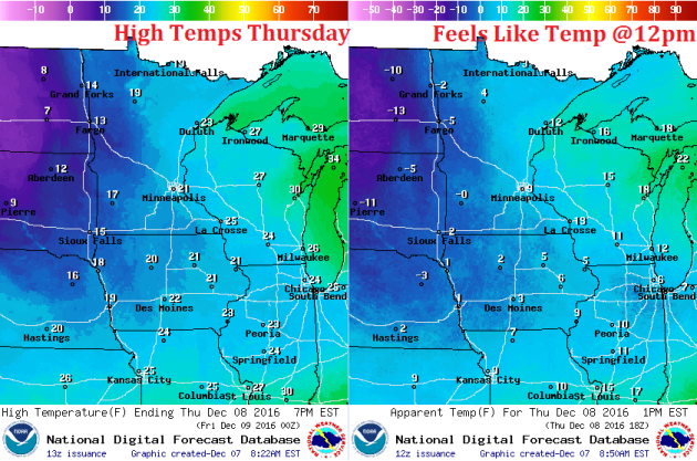
Weather Outlook Thursday
High temperatures on Thursday will again be quite cold. Daytime highs will be in the teens for much of the state with wind chills values in the single digits above and below zero. Note that wind chill values across the Dakota midday Thursday will still be stuck in the teens below zero!
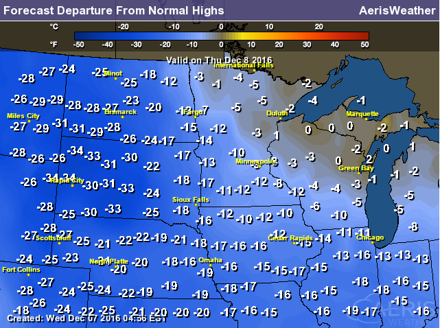
High Temperatures From Average Thursday
Here's a look at high temperatures from average on Thursday suggest well below average temperatures, especially across the Dakotas where temperatures will be nearly -20F to -30F below average. High temperatures across the state of Minnesota will be nearly -5F to -15F below average, but it'll feel much colder than that.
Weather Outlook Thursday
Winds will be gusty across the state again on Thursday with sustained winds in the 10mph to 20mph range. Wind gusts will still exceed 25mph in spots across western and southern Minnesota, which means that wind chill values will be quite chilly for much of the day.
Weather Outlook Thursday
The weather outlook for Thursday shows widespread light snow showers and flurries continuing throughout much of the day. We won't see much in the way of accumulation, except along the south shore of Lake Superior where heavy lake effect snow will taking place.
___________________________________________________________
Simulated Radar
The simulated radar from Wednesday to AM Saturday shows continued light snow showers and flurries tapering through Thursday. Gusty winds will also begin to fade by the end of the week before our next storm system moves in this weekend with more snow. Shovelable snow is looking likely for many across the southern half of the state through PM Saturday through AM Sunday. Stay tuned.
Snowfall Potential
Here's the snowfall potential through Midday Saturday, which shows snow tapering across northern MN through the end of the week as our current stubborn storm system slowly winds down. Note the next batch of snow starting to take shape across South Dakota and western MN. This is the next snow event that will move in across the southern half of the state during the PM hours of Saturday.
Somewhat Active Pattern With Colder Temps Ahead.
Here's the weather outlook through Sunday. Scattered light snow showers fade through the end of the week across the Upper Midwest and transition into heavy lake effect snow across parts of the Great Lakes Region as the cold air settles south. The next system rolls through the Upper Midwest this weekend with the potential of shovelable/plowable for some. Stay tuned!
__________________________________________________________________________
8 to 14 Day Temperature Outlook
According to NOAA's CPC, the 8 to 14 day temperature outlook suggests colder than average temperatures continuing through the 3rd weekend of December.
___________________________________________________________________________
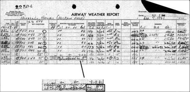
75th Anniversary of the Bombing of Pearl Harbor
December 7th, 2016 was the 75th anniversary of the bombing of Pearl Harbor. Here's something weather related and it's really interesting... Here are the weather observations taken at the time of the bombing of Pearl Harbor at the Honolulu Airport (Hickman Field).
_________________________________________________________________________________
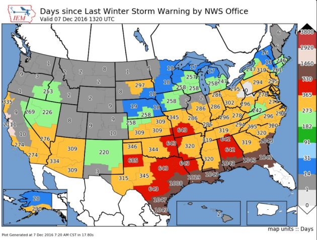
Days Since Last Winter Storm Warnings Issued By NWS Office
Here's an interesting graphic from IEM that shows the number of days it has been since it has been since local NWS offices have issue Winter Storm Warnings for their specific county warning area. Note that it has been nearly 1 to 2 years since some locations in the South central US have been under a Winter Storm Watch!
__________________________________________________________________________________
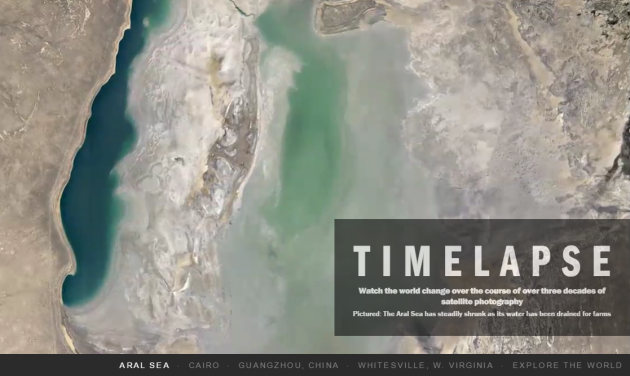
"Google Unveils a 3-Decade Time-Lapse of the Earth"
WOW! This is pretty spectacular. Take a look at what 30 years has done to some spots across the world. The fine folks at Google put these amazing time lapses together:
See the full story from TIME HERE:
"In the years all of the satellites have been flying they’ve taken millions upon millions of high-definition images, which NASA and the U.S. Geological Survey (USGS) have collated and assembled into something of a flip book that reveals the slow but steady alteration of our world. What the two science agencies started, the folks at Google have finished, turning the usually choppy, sometimes-hazy images into smoothly streaming videos, revealing decades of topographic changes in 10-second sweeps. (Click for source material). Those brief glimpses belie the extraordinary amount of computer-engineering muscle that went into making the mini-movies possible. The Google Earth Engine team worked with more than 5.4 million discrete images taken since 1984, and gave each one individual attention. In some, cloud cover had to be scrubbed away; in others missing pixels had to be filled in. In all of the images, there were plenty of those pixels to attend to. The average high-definition TV image is made of about 300,000 individual points of light. The Google time-lapse images pack 3.95 trillion pixels into a single frame."
(Image Credit: Google via TIME: The Areal Seas has steadily shrunk as its water has been drained for farms)
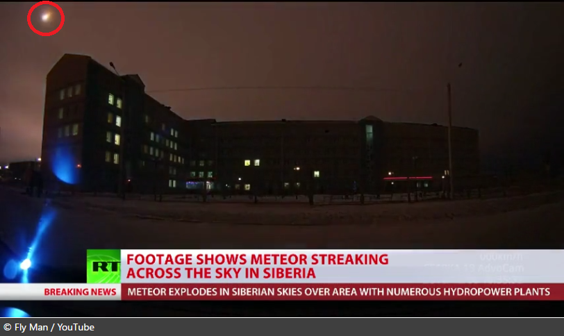
"Meteor explodes over Siberian city, turning night into day"
A large fireball was reported earlier this week in over a Siberian city, which brightened the night sky. It was also caught on camera. Take a look at the video link below from RT.com:
"People in the Republic of Khakassia in southwest Siberia witnessed a large fireball exploding in the sky on Tuesday, which briefly made the evening as bright as the day. Some even managed to catch the event on camera. “At first, I couldn’t understand what’s going on. There was a sudden luminescence. It wasn’t as light as day, but still quite bright,” witness Olga Sagalakova told RT. “We looked at the mountain near us… and there was huge meteor flying above it. It had a tail. Frankly, I was scared. I thought that it was a bomb,” she said."
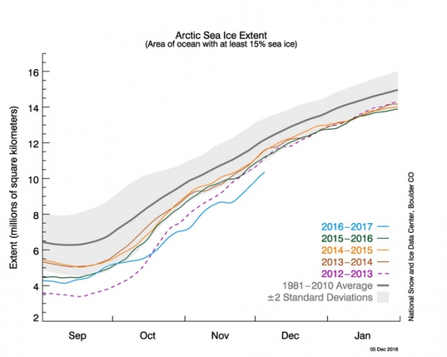
"Arctic Sea Ice Sees Strange Cold Season Retreat"
Arctic sea ice has been receding at unprecedented rate as new record low ice extents were set during the month of November. Here's an excerpt from Climate Central:
The Arctic is missing a chunk of sea ice the size of Mexico. While fall ushers in the season of sea ice growth, November saw a brief retreat that was virtually unprecedented in nearly 40 years of satellite records, according to data released Tuesday by the National Snow and Ice Data Center. That dip helped November set a record low for sea ice area — the seventh month to do so this year, also a record. At the opposite pole, the sea ice fringing Antarctica also set a record low for November, reversing several years of record highs, though what’s driving the flip-flopping isn’t clear. “It is very striking this November in both hemispheres,” NSIDC scientist Julienne Stroeve said in an email. “It certainly is continuing the long-term decline in Arctic sea ice. It’s a bit more curious about what is happening in Antarctica, so more research on that is needed.”
See more from Climate Central HERE:
(The daily Arctic sea ice extent as of Dec. 5, 2016, along with daily ice extent data for four previous years. 2016 is shown in blue, 2015 in green, 2014 in orange, 2013 in brown, and 2012 in purple. The 1981 to 2010 average is in dark gray. Credit: National Snow and Ice Data Center)
 ___________________________________________________________________________
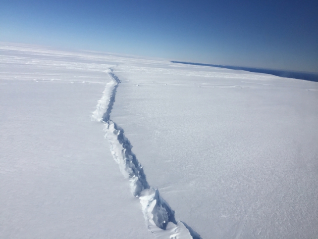
"Odd Rifts in Antarctic Ice Could Mean ‘Sayonara, Glacier’"
Here's another excerpt from Climate Central regarding unusual rifts in Arctic sea ice that could point to contributions in global sea level rises.
In August of 2015, a large iceberg broke off from the floating section of Antarctica’s massive Pine Island Glacier. While such an event is part of the natural life cycle of glaciers, this one was precipitated by an unusual rift in the middle of the ice that could point to a new mechanism for the collapse of this and potentially other glaciers, accelerating their contributions to global sea level rise. The researchers think the rift was caused by the same warm ocean waters that have been spilling into the cavities below many Antarctic ice shelves, driven by changes in wind patterns potentially linked to the warming climate, and eating away at them from below. As the ice shelves have thinned, the glaciers have flowed more quickly to the sea, adding once land-bound ice to the ocean.
See more from Climate Central HERE:
(This rift, photographed during NASA's Operation IceBridge on Nov. 4, 2016, is the second to form in the center of the ice shelf in the past three years. The first resulted in an iceberg that broke off in 2015. Credit: NASA/Nathan Kurtz)
 _____________________________________________________________________________
"What You Should Know About Trump’s Cabinet & Climate"
Are you interested in politics? Are you interested in climate change? Here's an excerpt from Climate Central regarding President-elect Trump's cabinet and there views on climate change... if you're interested.
"As President-elect Donald Trump continues to round out his cabinet and White House staff, his policies and priorities are coming more into focus. All indications so far point to a bleak future for addressing climate change, or even recognizing it as one of the world’s largest challenges. A number of his cabinet nominees, political appointees and closest advisors are outright climate deniers while others have funded the denial of climate change or are lukewarm on accepting the science. At best, climate action will likely take a backseat to other issues. At worst, there could be an all-out assault on the science, and as important, the funding that makes it possible. To glean a clearer picture of where Trump’s administration stands and where it may be headed, we’ve created a list of his major cabinet and agency appointees as well as his senior advisors. We’ll continue to update this as appointments are made."
See more from Climate Central HERE:
(Donald Trump with Lt. General Michael Flynn on the campaign trail. Flynn will serve as Trump's National Security Advisor. Credit: Mike Segar/REUTERS)

________________________________________________________________________________Arctic sea ice has been receding at unprecedented rate as new record low ice extents were set during the month of November. Here's an excerpt from Climate Central:
The Arctic is missing a chunk of sea ice the size of Mexico. While fall ushers in the season of sea ice growth, November saw a brief retreat that was virtually unprecedented in nearly 40 years of satellite records, according to data released Tuesday by the National Snow and Ice Data Center. That dip helped November set a record low for sea ice area — the seventh month to do so this year, also a record. At the opposite pole, the sea ice fringing Antarctica also set a record low for November, reversing several years of record highs, though what’s driving the flip-flopping isn’t clear. “It is very striking this November in both hemispheres,” NSIDC scientist Julienne Stroeve said in an email. “It certainly is continuing the long-term decline in Arctic sea ice. It’s a bit more curious about what is happening in Antarctica, so more research on that is needed.”
See more from Climate Central HERE:
(The daily Arctic sea ice extent as of Dec. 5, 2016, along with daily ice extent data for four previous years. 2016 is shown in blue, 2015 in green, 2014 in orange, 2013 in brown, and 2012 in purple. The 1981 to 2010 average is in dark gray. Credit: National Snow and Ice Data Center)
"Odd Rifts in Antarctic Ice Could Mean ‘Sayonara, Glacier’"
Here's another excerpt from Climate Central regarding unusual rifts in Arctic sea ice that could point to contributions in global sea level rises.
In August of 2015, a large iceberg broke off from the floating section of Antarctica’s massive Pine Island Glacier. While such an event is part of the natural life cycle of glaciers, this one was precipitated by an unusual rift in the middle of the ice that could point to a new mechanism for the collapse of this and potentially other glaciers, accelerating their contributions to global sea level rise. The researchers think the rift was caused by the same warm ocean waters that have been spilling into the cavities below many Antarctic ice shelves, driven by changes in wind patterns potentially linked to the warming climate, and eating away at them from below. As the ice shelves have thinned, the glaciers have flowed more quickly to the sea, adding once land-bound ice to the ocean.
See more from Climate Central HERE:
(This rift, photographed during NASA's Operation IceBridge on Nov. 4, 2016, is the second to form in the center of the ice shelf in the past three years. The first resulted in an iceberg that broke off in 2015. Credit: NASA/Nathan Kurtz)
"What You Should Know About Trump’s Cabinet & Climate"
Are you interested in politics? Are you interested in climate change? Here's an excerpt from Climate Central regarding President-elect Trump's cabinet and there views on climate change... if you're interested.
"As President-elect Donald Trump continues to round out his cabinet and White House staff, his policies and priorities are coming more into focus. All indications so far point to a bleak future for addressing climate change, or even recognizing it as one of the world’s largest challenges. A number of his cabinet nominees, political appointees and closest advisors are outright climate deniers while others have funded the denial of climate change or are lukewarm on accepting the science. At best, climate action will likely take a backseat to other issues. At worst, there could be an all-out assault on the science, and as important, the funding that makes it possible. To glean a clearer picture of where Trump’s administration stands and where it may be headed, we’ve created a list of his major cabinet and agency appointees as well as his senior advisors. We’ll continue to update this as appointments are made."
See more from Climate Central HERE:
(Donald Trump with Lt. General Michael Flynn on the campaign trail. Flynn will serve as Trump's National Security Advisor. Credit: Mike Segar/REUTERS)
Donald Trump is TIME's Person of the Year for 2016
TIME's Person of the Year goes to President-elect Trump. Interestingly, this is the 90th time they've name a Person of the Year. Here's an excerpt from TIME regarding their decision:
"This is the 90th time we have named the person who had the greatest influence, for better or worse, on the events of the year. So which is it this year: Better or worse? The challenge for Donald Trump is how profoundly the country disagrees about the answer.It’s hard to measure the scale of his disruption. This real estate baron and casino owner turned reality-TV star and provocateur—never a day spent in public office, never a debt owed to any interest besides his own—now surveys the smoking ruin of a vast political edifice that once housed parties, pundits, donors, pollsters, all those who did not see him coming or take him seriously. Out of this reckoning, Trump is poised to preside, for better or worse."
See more from TIME HERE:
(Image Credit: Photograph by Nadav Kander for TIME)

Thanks for checking in and don't forget to follow me on Twitter @TNelsonWX

No comments:
Post a Comment