Snowy Weekend Ahead. Plowable Across Southern Half of State.
Here's the snowfall potential through PM Monday, which shows the next round of snow pushing in across much of the state through the day Saturday and wrapping up early Sunday. Model runs have been consistently keeping the heaviest across the southern part of the state with a swath of 4" to 8" along the MN/IA border. Light amounts will be found in central and northern Minnesota, but because temperatures will be so cold, the snow will be fluffy and add up across much of the state.
If you have travel plans this weekend from Minneapolis to Madison, Milwaukee, Chicago or Detroit, be ready for heavy snow and major travel disruptions. The loop below shows the development of the snow across the Midwest and Great Lakes region from Saturday to AM Monday as the storm system pushes east.
.gif)
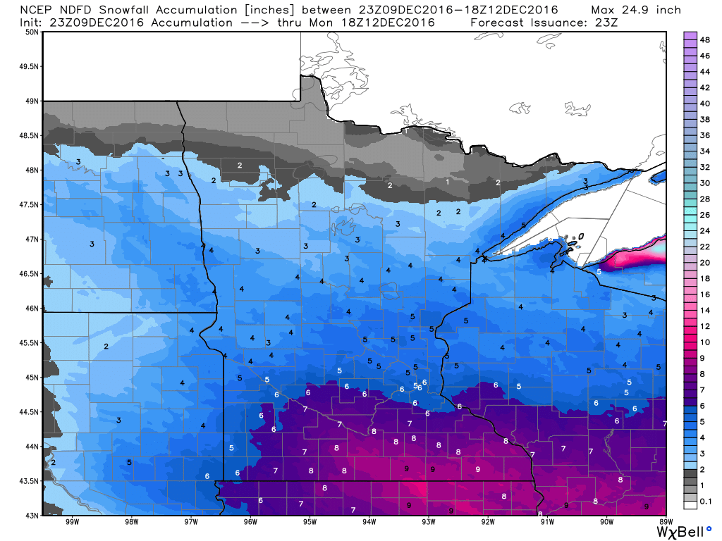
Snowfall Accumulations
The animation below shows the total snowfall accumulations from Saturday to AM Monday across the region. Note that the heaviest snowfall tallies will be from near Sioux Falls, SD to Madison, WI, Milwaukee, WI, Chicago, IL and Detroit, MI. Some spots could see up to 6" to 12" by the end of the weekend.
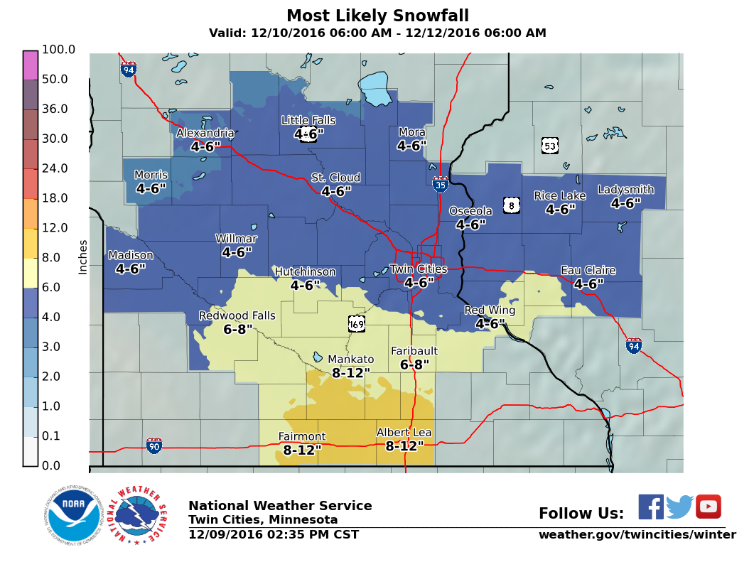
Minneapolis Snowfall Potential
Take a look at the potential snowfall accumulations for the Twin Cities and surrounding areas through Monday morning. Note that the heaviest will be across southern MN with lighter amounts farther north. However, there is a chance for some 4" to 6" tallies across the Twin Cities.
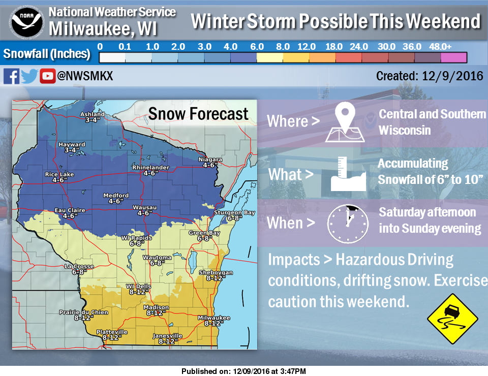
Wisconsin Snowfall Potential
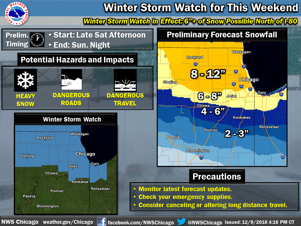
Here's the snowfall potential for Wisconsin, which shows the heaviest snowfall across southern Wisconsin. Note that Madison and Milwaukee could see 8" to 12" through the end of weekend.
Snow for Chicago, IL
Heavy snowfall is also expected for the Chicagoland region where as much as 8" to 12" can't be ruled out by the end of the weekend. This will certainly make for difficult travel conditions around the region, which will likely persist into early next week.
________________________________________________________
First the Snow and then the MORE Cold!
Take a look at the animation from Saturday, December 10th to Saturday, December 17th below, which shows the continuation of the Arctic air plunging across the Lower 48 over. Our first wave of Arctic air will begin to fade, while a another, even cold air surges south of the international border next week.
 High Temperatures From Average Next Wednesday
 Backwards Trajectory Model
____________________________________________________________________________
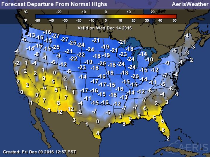
Temperatures over the weekend will moderate a little over the course of the weekend, but the secondary surge of Arctic air will provide another blog of exceptionally cold air across the nation. Here's the high temperatures from average on Wednesday of next week. Note that many locations in the Central US will be nearly 10F to 20F below average.
________________________________________________________________________
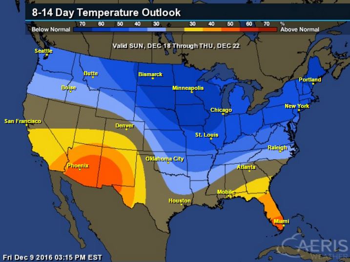
8 to 14 Day Temperature Outlook
According to NOAA's Climate Prediction Center, the 8 to 14 day temperature outlook suggests that colder than average temperatures will be with much of us in northern tier of the nation and across much of the eastern half of the country. The coldest of which will be found across the Upper Midwest and Great Lakes Region. With that said, look for several bouts of lake effect snow over the next couple weeks.
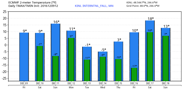
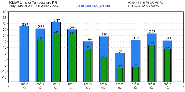
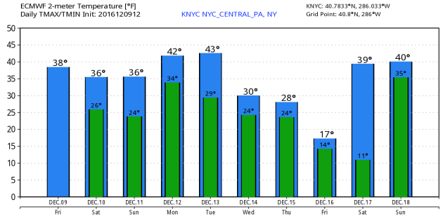
Extended Outlook for KINL - KORD - KNYC
Take a look at the extended outlook for International Falls, MN - Chicago, IL - New York, NY - which shows colder temperatures through the rest of the week and weekend ahead. Especially note the forecast into next week for International Falls, MN, where high temperatures could actually be below zero. That secondary surge of Arctic air is also evident in Chicago, IL as temperatures dip even further by midweek next week. Even though the air mass will be modified later next week, you can still see a drop in temps for New York, NY by the end of next week.
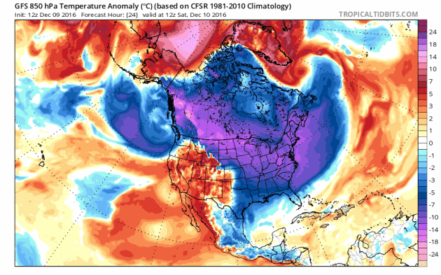
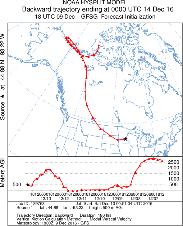
Here's an interesting look at the backwards trajectory of the air mass that will be in place by Wednesday, December 14th in Minnesota. Note that the origins are traced back directly from the Arctic!
____________________________________________________________________________
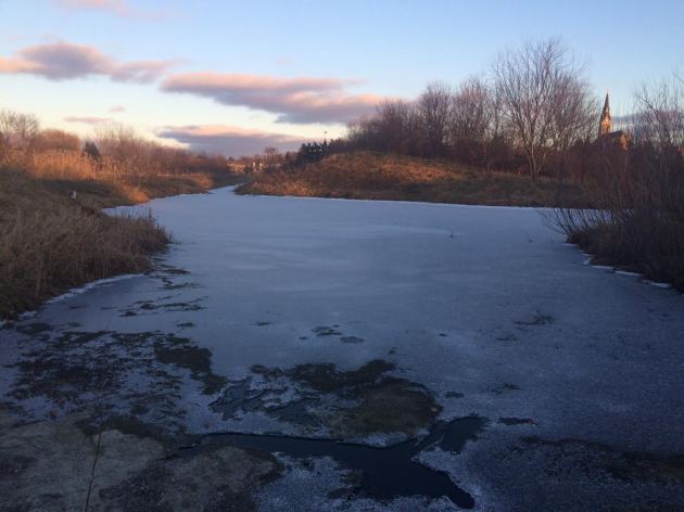
Ice Safety
Ice beginning to form on area lakes and ponds, but it is important to remember that the ice is NOT safe yet! We need several more days/weeks of this colder weather before you can even attempt to get out there...
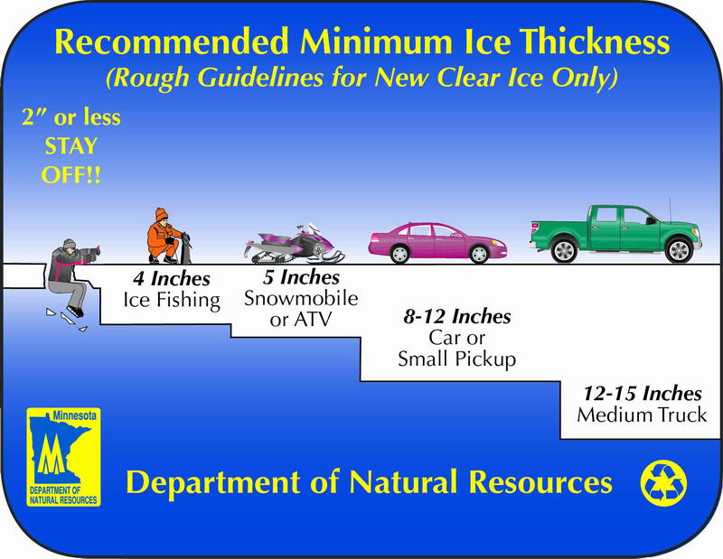
Ice Safety
Remember that no ice is ever 100% safe, but here is the recommended ice thickness as the colder winter weather settles in. Note that to safely walk on ice, you need at least 4" of ice. Small cars and trucks need close to a foot of ice or more before you can even think about going out.
_________________________________________________________________________
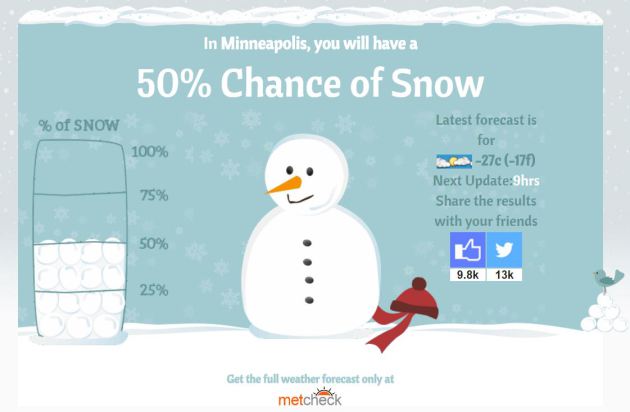
Will I Get A White Christmas?
Here's a neat website from MetCheck that tells you if you'll get a white Christmas. I typed in Minneapolis and it said there's a 50% chance!
Check it out HERE:

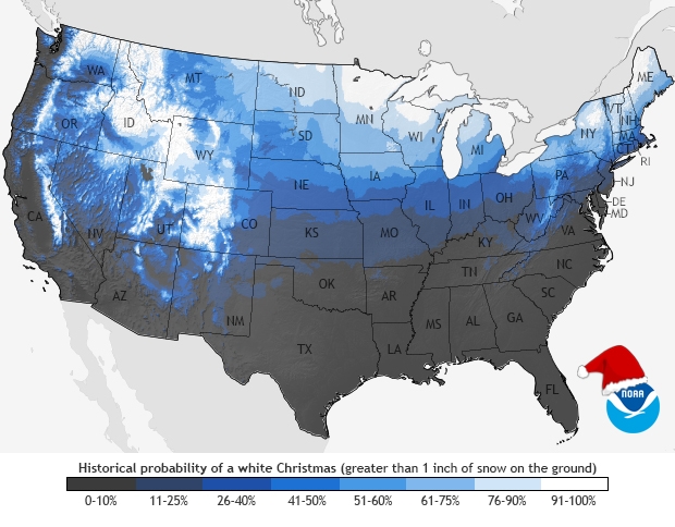
Are you wondering what your average probability is of a white Christmas? Here's a look from NOAA. Note that the bright white colors indicate a near 9 out of ever 10 Christmases in white, which means that there is at least 1" of snow on the ground on December 25th.
See more from NOAA HERE:
_________________________________________________________________________________
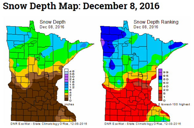
Here's the latest weekly snow depth map from the State Climatology Office, which shows that we've had a fairly decent increase in the snow pack across the northern half of the state last week. The heaviest snow sits across the Red River Valley in far northwestern MN and also across the Arrowhead.
"Each Thursday during the cold season, the State Climatology Office produces maps depicting the snow depth across Minnesota. Additionally, maps are created that depict snow depth ranking for the date. The data are provided by volunteers working with DNR Forestry, the National Weather Service, the University of Minnesota, Soil and Water Conservation Districts and CoCoRaHS."
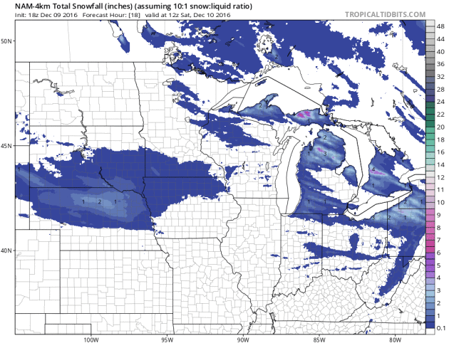
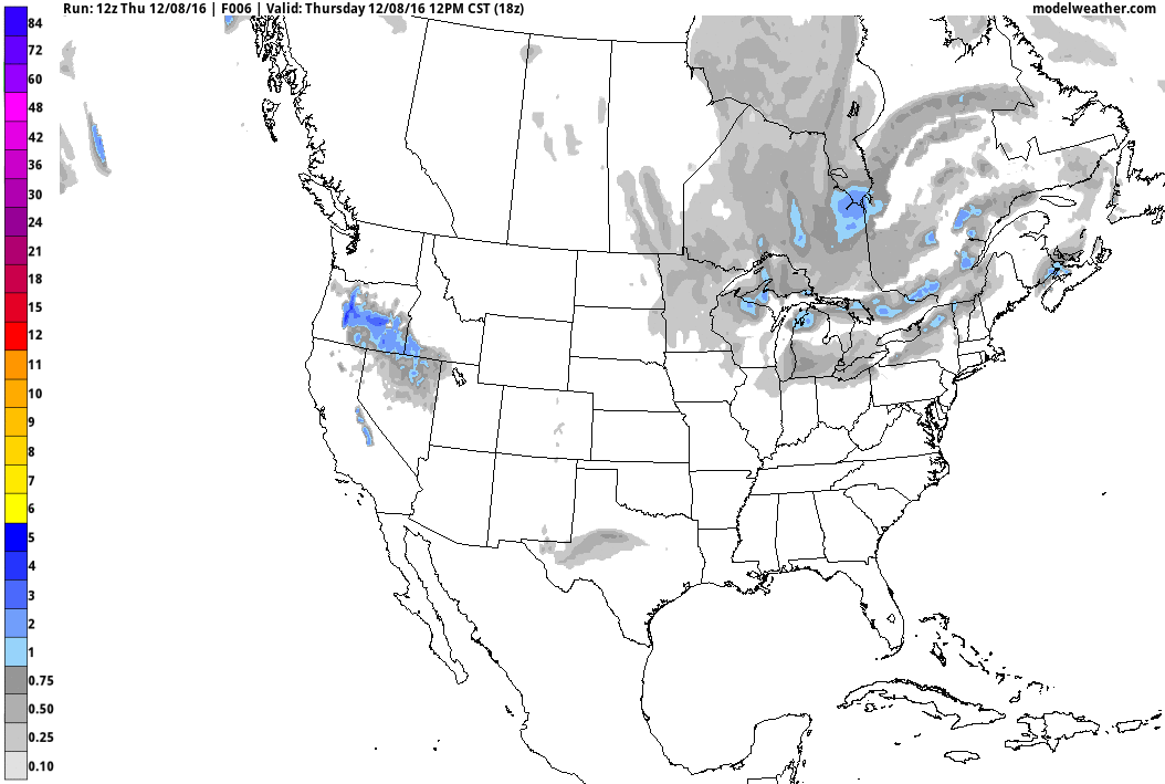
Here's the national weather outlook through Monday night, which shows the next surge of Pacific moisture sliding into the Central US with heavy snow across the Upper Midwest and the Great Lakes through the weekend. This will be a plowable snow for many before moving into the Northeast with a wintry mix and pockets of heavier rain.
.gif)
10-Day Snowfall Outlook
Here's the 10 day snowfall potential, which shows heavier snow across the Great Lakes Region and the higher elevations in the Western U.S.. A steady stream of Pacific moisture may translate into heavier snow over the next several days across parts of the northern tier of the nation. Some of these events could produce shovelable/plowable amounts of snow across a wider area that could impact many across the country. Now that colder air is in place across the country, any moisture that moves through will have a better chance of falling in the form of snow.
Here's the 10 day snowfall potential, which shows heavier snow across the Great Lakes Region and the higher elevations in the Western U.S.. A steady stream of Pacific moisture may translate into heavier snow over the next several days across parts of the northern tier of the nation. Some of these events could produce shovelable/plowable amounts of snow across a wider area that could impact many across the country. Now that colder air is in place across the country, any moisture that moves through will have a better chance of falling in the form of snow.
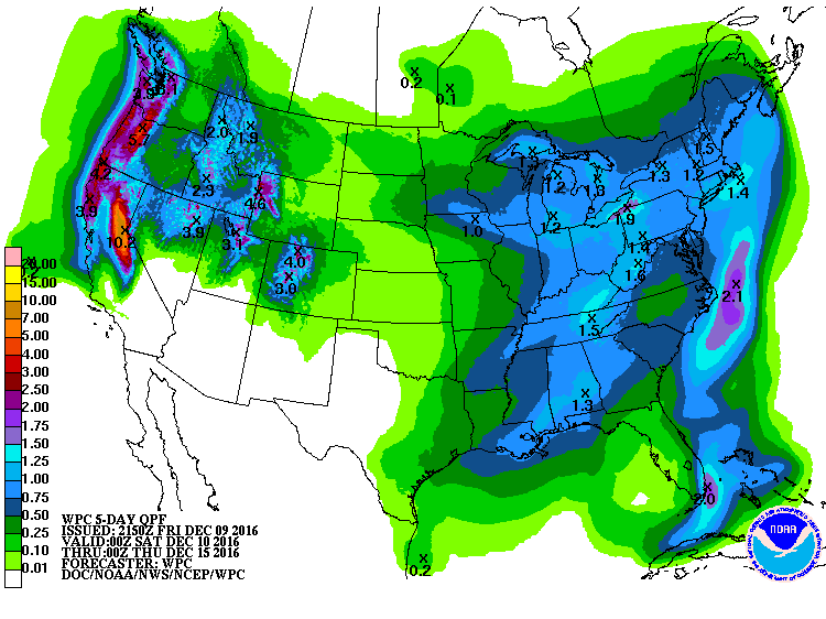
5 Day Precipitation Outlook
According to NOAA's WPC, the 5 day precipitation outlook suggests heavy precipitation in the Western US, especially along the coast in the higher elevations. Some spots could see as much as 4" to 8" with some 10" liquid tallies through early next week. Much of the precipitation in the Western US will fall in the form of heavy snow in the mountains. Some spots could see 1ft. to 2ft. of snow through the weekend. Also note the heavy moisture around the Great Lakes, which will fall in the form of heavy lake effect snow over the next several days! There will also be some decent liquid tallies across parts of the Tennessee Valley and into Kentucky, which will further help the drought.
 _____________________________________________________________________________
I have to admit, I've been chomping at the bit for a little snow. There's just something about a fresh coating and holiday lights that makes the season brighter.
No question, it has been a slow start to winter here in the Twin Cities. As of yesterday, MSP has only seen 4.7 inches of snow, which is nearly 8.5 inches below average. Note that we were nearly 7 inches below average during the month of November and already about 1 inch below average for the month of December.
Snow lovers will enjoy the weekend forecast as shovelable snow passes through the southern half of the state. While the Twin Cities metro looks to get missed by the heaviest stuff, 4 to 8 inches could fall along the Minnesota/Iowa border by Sunday. 6 to 12 inches of snow could fall in Milwaukee and Chicago as the system slides east through the rest of the weekend.
Arctic air will then plunge into the region with daytime highs in the single digits and overnight lows below zero for much of next week.
Grab your shovels and long johns. Winter is finally here!
___________________________________________________
Extended Weather Outlook
FRIDAY NIGHT: Mostly cloudy and cold. Winds: NW 5. Low: 4
SATURDAY: Clouds increase, snow develops later. Light coating possible by evening. Winds: E 5-10. High: 16.
SATURDAY NIGHT: Snow. 1" to 3" possible across the metro, heavier in southern MN. Winds: E 5-10. Low: Rising to 16 by morning.
SUNDAY: Light snow lingers. Up to an additional 1" possible. Winds: NNE 5-10. High: 20.
MONDAY: Arctic front arrives. A few PM flurries. Winds: WNW 5-15. Wake-up: 13. High: 18.
TUESDAY: Bitter sunshine. Icy winds. Winds: WSW 10-15. Wake-up: 3. High: 7.
WEDNESDAY: Partly cloudy. Very cold. Winds: WNW 5-15. Wake-up: -4. High: 6.
THURSDAY: Face-numbing wind chills. Winds: W 5-15. Wake-up: -5. High: 7.
FRIDAY: Deep freeze continues. Winds: NW 5-10. Wake-up: -3. High: 8.
_______________________________
_______________________________
This Day in Weather History
December 10th:
1992: By this time there is partial ice cover in the Duluth harbor.December 10th:
1979: A 'heat wave' develops across Minnesota. Highs of 54 at Twin Cities and 57 at Winona are recorded.
1978: Alexandria ends its fourteen day stretch of low temperatures at or below zero degrees Fahrenheit.
1889: A late season thunderstorm is observed at Maple Plain.
________________________________
Average High/Low for Minneapolis
December 10th
Average High: 29F (Record: 54F set in 1979)
Average Low: 14F (Record: -18F set in 1977)
Average Low: 14F (Record: -18F set in 1977)
Record Snowfall: 1.8" set in 2013
_________________________________
_________________________________
Sunrise/Sunset Times for Minneapolis
December 10th
December 10th
Sunrise: 7:39am
Sunset: 4:32pm
Sunset: 4:32pm
*Daylight Lost Since Yesterday: ~57sec
*Daylight Lost Since Summer Solstice: ~6hours and 42mins
______________________________________________________________________
*Daylight Lost Since Summer Solstice: ~6hours and 42mins
______________________________________________________________________
Moon Phase for December 9th at Midnight
2.9 Days Since First Quarter
2.9 Days Since First Quarter
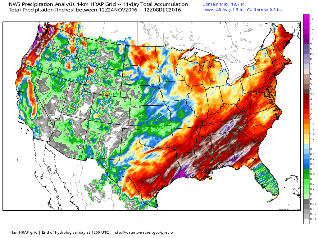
Rainfall Past 14 Days
Take a look at the precipitation over the last 14 days. Note the heaviest swath from parts of eastern Texas through the Gulf Coast States and Tennessee Valley. Some spots have seen nearly 6" to 10"+ over that time period, which is wonderful news conditions these are some of the areas under the worst drought.
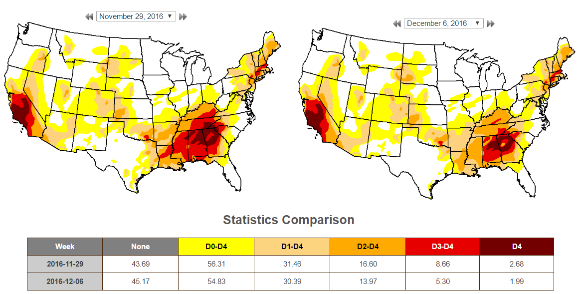
US Drought Monitor
According to the US Drought Monitor, there has been a decent improvement in the national drought. The biggest change comes in the extreme category that went from 8.66% national down to 5.3% nationally. Much of this improvement was seen in the Southeast.
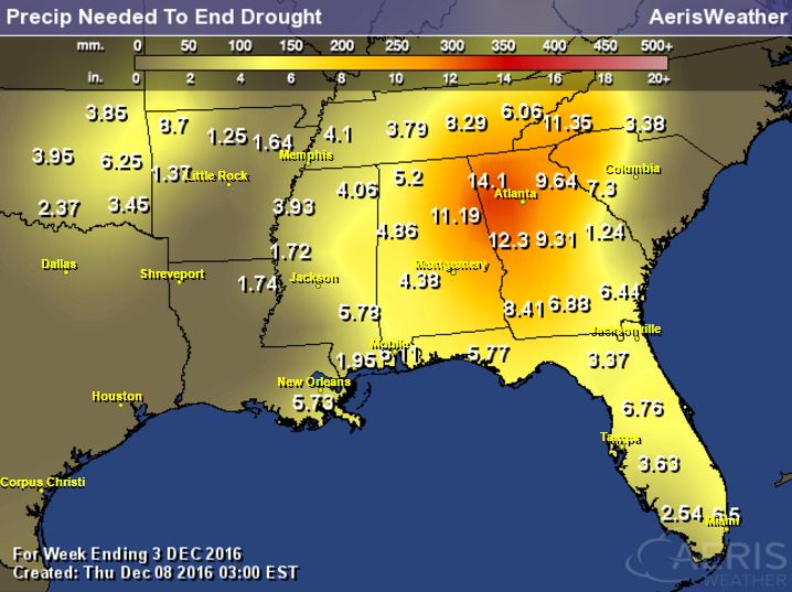
Precipitation Needed to End Drought in the Southeast
Even after all the rain we've seen in the Southeast, we still need several more inches of rainfall to end the drought there. Some spots still need another 6" to 10"+.
________________________________________________________________________________
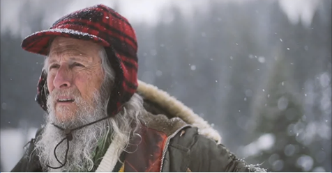
"The Snow Guardian"This is a neat story... A weather observer is Gothic, Colorado collected weather data for 40 years and researchers stumbled upon his data to find evidence of climate change. Here's an excerpt from SLATE:
"Billy Barr observed the snow in a Colorado town for 40 years to pass the time. Then researchers stumbled on his data. Scientists love him. Every day for 40 years, Billy Barr has collected data about snow in the town of Gothic, Colorado, where he lives. He does it just to pass the time, but his data has been invaluable to climate scientists. Researchers at the Gothic-based Rocky Mountain Biological Lab stumbled upon Barr’s data and used it to find clear evidence of climate change. In a typical winter, it’s normal to have four or five record-high temperatures. Last year, Barr recorded 36."
See the full story and short video from Slate HERE:
(Image credit: Slate)
_________________________________________________________________
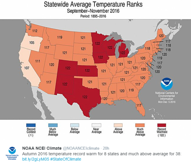
Warmest Autumn (Sept. - Nov.) on Record for Contiguous U.S.
According to NOAA, if you lived in Minnesota, Wisconsin, Iowa, Michigan, Colorado, Kansas, New Mexico or Texas, you just lived through the WARMEST autumn (September - November) on record! As a whole, the contiguous U.S. also had its warmest autumn on record as the average temperature ran nearly 4F above average!
See more from NOAA's State of the Climate HERE:
______________________________________________________________________________
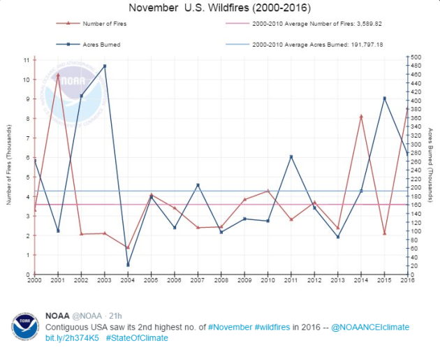
U.S. Had Its 2nd Highest Number of November Wildfires in 2016
According to NOAA, there were nearly 8,560 wildfires across the Lower 48 during the month of November, which becomes the 2nd highest number of wildfires during the November.
"Wildfires: In November, 8,560 wildfires raged across the Continental U.S. and burned more than 275,000 acres, most notably in the Southeast."
See more from NOAA HERE:
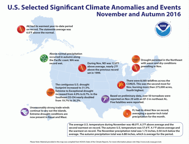
 _______________________________________________________________________________"Significant Climate Anomalies & Events for November and Autumn 2016"
Here are some of the most noteworthy climate events that happened during November and Autumn of 2016. Note that much of these climate events included either warmer than average temperatures or drought/wildfire concerns.
-Drought: The area of extreme to exceptional drought in the Lower 48 increased from 4.9% to 8.7%; in -the Southeast it nearly doubled from 19.7% to 36.2%.
-Wildfires: In November, 8,560 wildfires raged across the Continental U.S. and burned more than 275,000 acres, most notably in the Southeast.
-North Dakota experienced temperatures 12.8 degrees F above average, nearly 2 degrees above the previous record set in 1999.
-Alaska experienced its warmest year to date on record, a full 6 degrees F above average.
Pacific Northwest experienced above-normal precipitation during autumn along the coast. Washington state was record wet.
See more from NOAA HERE:
See more from NASA HERE:
 _________________________________________________________________
"NASA Made a Really Dumb Mistake on an ISS Power Supply"
_________________________________________________________________
"NASA Made a Really Dumb Mistake on an ISS Power Supply"
"The INTERNATIONAL SPACE STATION is currently home to six intrepid astronauts, one Robonaut, and four 14,000-pound payload-holders called ExPRESS Logistics Carriers. Experiments from Earth like the laser-communicator OPALS fly up to Station and Lego-attach to these carriers, which provide them with a place to stay and, just as importantly, the electrical power and data links they need to do their jobs. But since 2013, scientists sending up payloads have had trouble with the on-orbit utility grid."
See more from WIRED HERE:
(Image Credit: NOAA)

According to NOAA, if you lived in Minnesota, Wisconsin, Iowa, Michigan, Colorado, Kansas, New Mexico or Texas, you just lived through the WARMEST autumn (September - November) on record! As a whole, the contiguous U.S. also had its warmest autumn on record as the average temperature ran nearly 4F above average!
See more from NOAA's State of the Climate HERE:
______________________________________________________________________________
According to NOAA, there were nearly 8,560 wildfires across the Lower 48 during the month of November, which becomes the 2nd highest number of wildfires during the November.
"Wildfires: In November, 8,560 wildfires raged across the Continental U.S. and burned more than 275,000 acres, most notably in the Southeast."
See more from NOAA HERE:
Here are some of the most noteworthy climate events that happened during November and Autumn of 2016. Note that much of these climate events included either warmer than average temperatures or drought/wildfire concerns.
-Drought: The area of extreme to exceptional drought in the Lower 48 increased from 4.9% to 8.7%; in -the Southeast it nearly doubled from 19.7% to 36.2%.
-Wildfires: In November, 8,560 wildfires raged across the Continental U.S. and burned more than 275,000 acres, most notably in the Southeast.
-North Dakota experienced temperatures 12.8 degrees F above average, nearly 2 degrees above the previous record set in 1999.
-Alaska experienced its warmest year to date on record, a full 6 degrees F above average.
Pacific Northwest experienced above-normal precipitation during autumn along the coast. Washington state was record wet.
See more from NOAA HERE:
_______________________________________________________________
"Cassini Beams Back First Images from New Orbit"
Unreal! Cassini, a satellite that was launched in 1997 to explore Saturn, is sending back new images and they are pretty amazing! Here's an excerpt from NASA:
"NASA's Cassini spacecraft has sent to Earth its first views of Saturn’s atmosphere since beginning the latest phase of its mission. The new images show scenes from high above Saturn's northern hemisphere, including the planet's intriguing hexagon-shaped jet stream. Cassini began its new mission phase, called its Ring-Grazing Orbits, on Nov. 30. Each of these weeklong orbits -- 20 in all -- carries the spacecraft high above Saturn's northern hemisphere before sending it skimming past the outer edges of the planet's main rings."See more from NASA HERE:
"The INTERNATIONAL SPACE STATION is currently home to six intrepid astronauts, one Robonaut, and four 14,000-pound payload-holders called ExPRESS Logistics Carriers. Experiments from Earth like the laser-communicator OPALS fly up to Station and Lego-attach to these carriers, which provide them with a place to stay and, just as importantly, the electrical power and data links they need to do their jobs. But since 2013, scientists sending up payloads have had trouble with the on-orbit utility grid."
See more from WIRED HERE:
(Image Credit: NOAA)
Thanks for checking in and don't forget to follow me on Twitter @TNelsonWX

No comments:
Post a Comment