+ 1.3 F. As of December 30 St. Cloud temperatures in December are running over one degree above average.
5 minutes of additional daylight since December 21 in St. Cloud (!)
22 F. average high on December 31.
19 F. high in the Twin Cities on December 31, 2015.
January 1, 2003:
On this date there is an inch or less of snow on the ground from Duluth
to the Iowa border. In the Twin Cities there isn't even a dirty
snowbank to be found.
January 1, 1997: Freezing rain causes numerous accidents along the North Shore. In Lake County, vehicles could not get up hills and were blocking roads. Highway 61 was closed for several hours from Two Harbors to Silver Bay.
January 1, 1864: Extremely cold air moves into Minnesota. The Twin Cities have a high of 25 degrees below zero.
First Week of 2017 May Be Coldest Of The Year
So it's 2017, and still no flying car or robotic assistant, Westworld Edition. I can check Doppler on my watch, ask my phone questions and stream myself into a stupor. This is progress?
I predict another head-scratching year of weather in 2017; not quite as warm or wet as 2016. More flash floods, a better chance of late summer drought. Strangers will shout out "hot enough for 'ya?" The 7-Day will still be wrong. An inch of snow will lead area newscasts. Outdoor weddings will continue to attract severe thunderstorms. Some things never change...
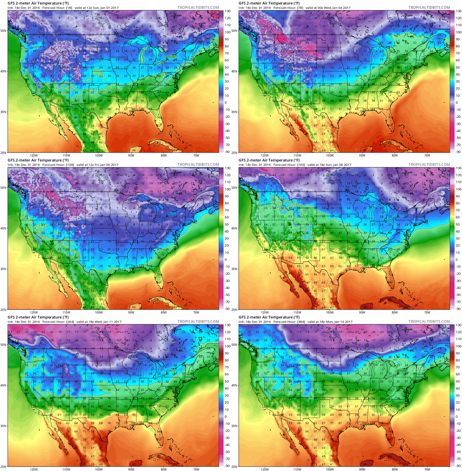
No record cold is brewing, but this should be one of the coldest weeks of winter; temperatures dipping below zero at least 4 nights, starting Wednesday. The arrival of brittle air sets off a little snow and ice from Sunday night into early Tuesday. An inch or 2 of slush may fall in the MSP metro; possibly enough to plow closer to Crosby and Duluth, but this doesn't look like The Big One.
Models pull another swipe of numbing air into Minnesota next week, but I see a shift in the pattern by mid-January. 30s by the 3rd week of January will restore your faith in 2017.
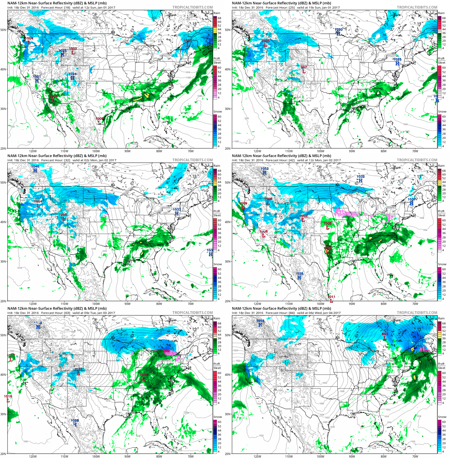
Weather Map Into Tuesday Night. The next storm pushes accumulating snow across the northern Rockies and Plains into the Upper Mississippi River Valley Sunday night into Monday night; plowable accumulations likely from Montana and North Dakota into northern Minnesota and the U.P. of Michigan. Meanwhile showery rains and T-storms push from the Mid South and Gulf Coast to the East Coast by Monday and Tuesday. Heavy rain showers push across Arizona and New Mexico today; the next storm approaching northern California by the middle of next week. 84-hour NAM guidance: Tropicaltidbits.com.
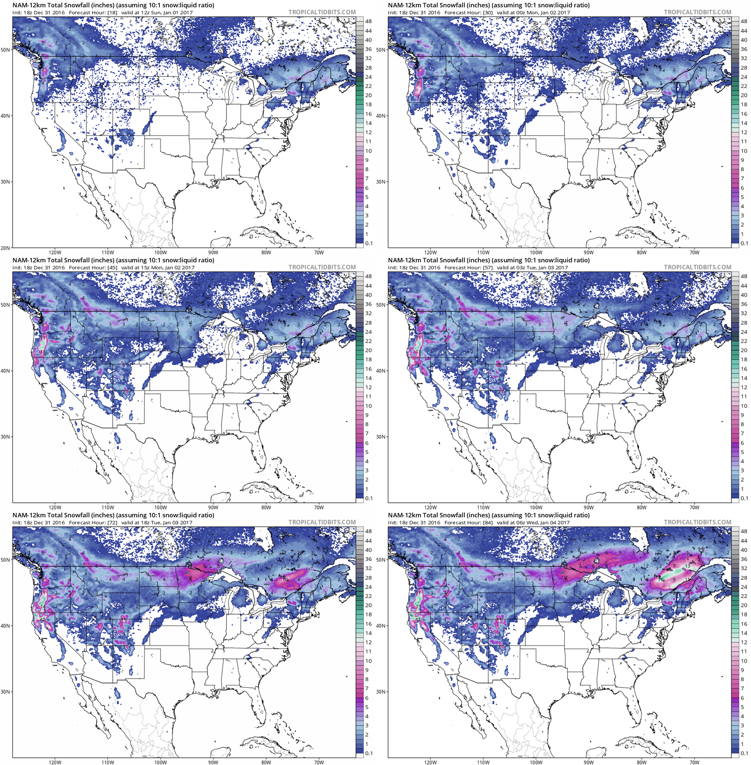
84-Hour Snowfall Forecast.
This time we've dialed up 12 KM NAM model guidance, which prints out
plowable amounts of snow from Bozeman and Billings to Bismarck, Fargo,
Bemidji, Brainerd, Hibbing and Duluth. Another 6-18" snow may pile up
from the Colorado Rockies to the Cascades
Pattern Shift Third Week of January?
It may be wishful thinking, but the pattern appears progressive. Unlike
2013-14 when patterns stalled, keeping a lobe of polar air over much of
the USA from January into February, there's no evidence (yet) that
steering winds will stall in a pattern that prolongs bitter cold.
There's some evidence milder, Pacific air will thaw things out during
the third week of January.
* Minnesota reported 37 tornadoes in 2016, the first on May 25th in Pope County, and the last on September 9th in Beltrami County. The majority were short-lived and EF-0 rated ( winds 65-85 mph), and there were four storms rated EF-2 (winds 111-135 mph).
* Early planting for Minnesota farmers, followed by a generally favorable growing season with mostly excellent crop yields around the state.
* 2016 was the first year ever to bring two mega-rain events (1000 square miles covered by 6 inches or greater) to the state: one in east-central counties over July 11-12; and one in west-central counties August 10-11. Widespread flash flooding resulted.
* Latest ever autumn killing frost in the Twin Cities on November 18th
* Tied for warmest ever autumn season (September-November) on a statewide basis with 1963.
* Overall on a statewide basis 2016 delivered the 3rd warmest year in history to Minnesota (only 1987 and 2012 were warmer) and the 2nd wettest year (only 1977 was wetter)...
Photo credit: Rick Barbero, The Register-Herald. "A house was forced from its foundation and floated onto Anjean Street in Rupert had to be cut in half to open up the lane."
Tracking Trends in U.S. Flood Risk. Eos connects the dots: "For 16 consecutive months in 2015 and 2016, Earth’s climate repeatedly broke global temperature records, in keeping with global warming trends observed over the past century and counting. During that period, there were major floods across the United States, including events in Missouri, Texas, Oklahoma, West Virginia, Maryland, and Louisiana. Warmer temperatures are associated with more frequent extreme precipitation events, and they increase the atmosphere’s water-holding capacity, suggesting that flooding across the globe will become more frequent in coming decades. Such an increase would have costly consequences for agriculture, water resources management, ecology, insurance, and transportation and navigation industries, as well as for civilians living in flood-affected areas. In light of this, hydrologists and atmospheric scientists are working to develop a more nuanced understanding of projected flooding changes to accurately communicate risks to the public..."
Photo credit: "Flooding near Houston, Texas, in April 2016." Credit: Tom Pistillo, USGS
Photo credit: "After Jennifer and Ben Deneen’s Houston home was destroyed in a flood, they built this new two-story home in its place." Photo: Casey Woods for The Wall Street Journal.
Solar Looks to Outpace Natural Gas and Wind. Scientific American reports: "2016 is shaping up to be a milestone year for energy, and when the final accounting is done, one of the biggest winners is likely to be solar power. For the first time, more electricity-generating capacity from solar power plants is expected to have been built in the U.S. than from natural gas and wind, U.S. Department of Energy data show. Though the final tally won’t be in until March, enough new solar power plants were expected to be built in 2016 to total 9.5 gigawatts of solar power generating capacity, tripling the new solar capacity built in 2015. That’s enough to light up more than 1.8 million homes..."
America's Mood Map: An Interactive Guide to the United States of Attitude. TIME reports; here are a few enlightening excepts: "...According to the study, the winners (or losers, depending on how you view these things) were in some cases surprising and in some not at all. The top scorers on extroversion were the ebullient folks of Wisconsin (picture the fans at a Packers game — even a losing Packers game). The lowest score went to the temperamentally snowbound folks of Vermont. Utah is the most agreeable place in the country and Washington, D.C., is the least (gridlock, anyone?)...The study, published in the Journal of Personality and Social Psychology, was an exhaustive one, spanning 13 years and including nearly 1.6 million survey respondents from the 48 contiguous states and the District of Columbia..."

Check Out "Eagle-Cam". A couple of bald eagles sitting on a nest in Fort Meyers, Florida are whipping up a lot of online interest, as reported at NBC News: "...The
eagle cam, hosted by a real estate company, has been chronicling
Harriet's nesting seasons since 2012. Then, 16 million people tuned in
to watch Harriet and her former mate Ozzie raise two eaglets from their
birth to fledge, according to the company's website. This year, the
stream has amassed more than 57,670,000 views so far, according to the
site. "We have a PIP in one egg!! The hatching process has begun," read a
post on the eagle cam website Thursday afternoon..."
The Live Camera link is here, courtesy of Dick Pritchett Real Estate. Talk about good advertising!
NEW YEAR'S DAY: Clouds increase, milder. Winds: SE: 5-10. High: 34
SUNDAY NIGHT: Light snow develops, mixed with sleet. Low: 28
MONDAY: Wintry mix, slushy inch or so. More north. Winds: E 10-20. High: 34
TUESDAY: Much colder with flurries. Slick spots. Winds: NW 15-30. Wake-up: 20. High: 23 (falling rapidly)
WEDNESDAY: Cold breeze with peeks of sun. Feels like -20F. Winds: NW 10-20. Wake-up: 2. High: 7
THURSDAY: Coldest day, bright sunshine. Feels like -25F. Winds: NW 7-12. Wake-up: -7. High: 2
FRIDAY: Clouds increase, few flurries. Winds: W 7-12. Wake-up: -4. High: 12
SATURDAY: Blue sky, more fresh air! Winds: NW 5-10. Wake-up: -3. High: 6
Climate Stories...
Image credit: Giphy.
Photo credit: "A deep gulley with rushing water feeds into a river on Petermann Glacier. The shelf has reached a record low size after losing pieces larger than Manhattan in recent years." (Whitney Shefte / The Washington Post)
Photo credit: "Stephen Hadley said climate change will be one of the top national security issues for the next administration." | RODNEY LAMKEY JR. for POLITICO.
Europeans Ask: Where's The Snow? Ski Resorts Severely Impacted. The Daily Mail Online has a photo essay showing area ski resorts; a lack of snow has left an estimated 45,000 people unemployed. Here's an excerpt: "...Unusually high temperatures and a lack of snow is threatening the ski season as popular resorts in Europe have completely shut down. Some resorts in France have not seen so much as a snowflake in almost a month, leaving pistes completely bare. An estimated 45,000 workers have been left temporarily unemployed, lifts remain stationary and nobody is skiing on the slopes in the worst-hit areas in Massif Central, The Vosges and The Jura in France as well as Charmey in Switzerland..."
Photo credit: "A closed ski slope in Charmey, Switzerland on Boxing Day where the resort is closed due to the lack of snow." EPA.
7 Places That Will Change Because of Global Warming in Our Lifetimes. Here's an excerpt from Bustle: "As we're selfish creatures, however, it's often difficult to make clear how intensely bad this is without talking about how it affects us: our cities, our food, our holiday destinations, our ability to stay safe from conflict and natural disaster. The real nature of global warming is, unfortunately, global. And the impacts will be devastating: a study released this year noted that some places will likely see ocean rises of six meters or more as ice sheets collapse and melt, and by 2050 it's estimated that areas currently inhabited by 150 million people will be either flooding regularly or underwater. That's a lot of humans with nowhere to go and a lot of land that can't produce food. We're headed for a very bumpy ride; here are seven of the places that will be hit particularly hard by global warming in our lifetimes..."
File photo of Miami Beach: Daniel Chudosov, Flickr.
No comments:
Post a Comment