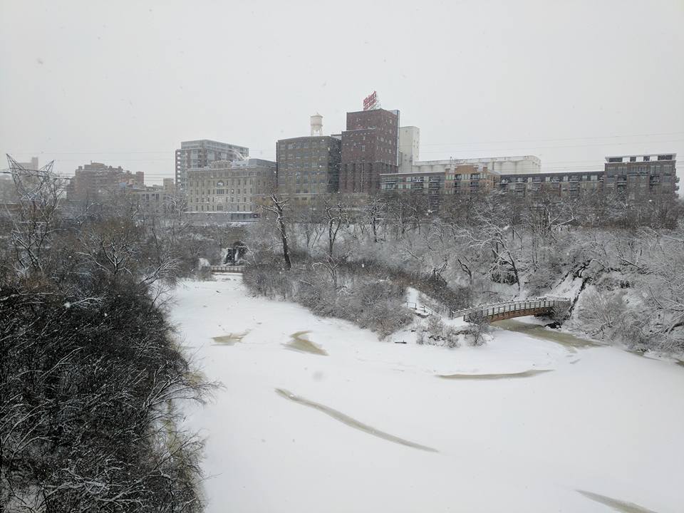
FINALLY! Some Fresh Snow...
Well that's more like it! It finally looks like winter around here. I'm not going to lie, I like it! Covers up the brown and makes the holiday season brighter. However, I am not a fan of the extreme cold and it looks like we're in for another surge of even cold air this week.
(Photo Credit: Lee Huffman)
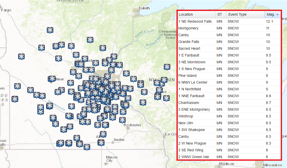
First Big Snow Event For the Twin Cities This Season
Here are some the the heaviest snowfall reports from the system this weekend. Note that Redwood Falls had a foot of snow, while several other 8"+ tallies were seen - even in the south metro! Snowfall tallies ranged from about 4" on the north side of town to as much as 8"+ on the south side of town.
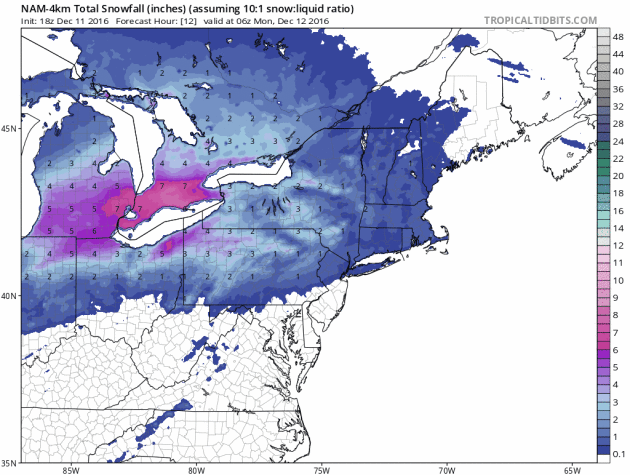
Snow Continues to Shift East
Here's the simulated radar from AM Monday to AM Tuesday, which shows the snow and wintry weather ending across the Northeast quickly this week. However, with that said, there will still be some fairly significant tallies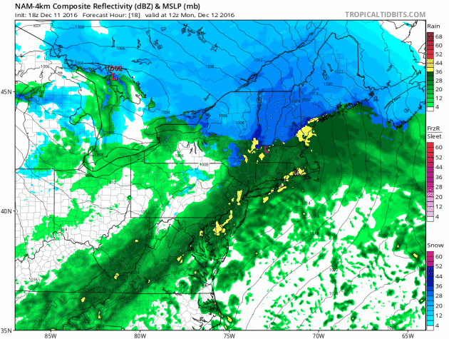
There are still a number of winter weather headlines across the Great Lakes and into the Northeast through Monday. The heaviest snow will wrap up across the Great Lakes early Monday, but will eventually end in the Northern New England States late Monday. Total snowfall accumulations could approach 6" to 12" in spots by the time this system wraps up.
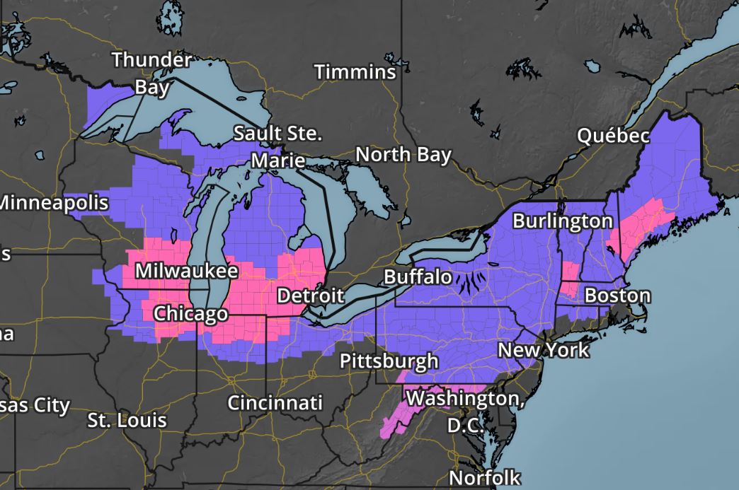
Northeast Snowfall Potential
Here's the additional snowfall potential through PM Tuesday, which shows heavy pockets of snow of 6" to near 10"+ mainly across the Northern New England States.
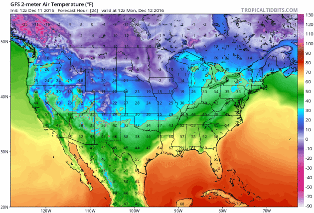
Here's a look a the surface temperature from Monday to Sunday, which shows another dump of Arctic air into the Lower 48. This surge will likely be even colder (across parts of the northern tier of the nation) than the one we dealt with last week. Note the white and purple colors, which indicate 0F and colder temperatures. Many locations across the far north will likely see several days with low temps in the sub-zero range. Wind chill values will certainly be colder, some spots could see values in the 20s below zero!
____________________________________________________________________________
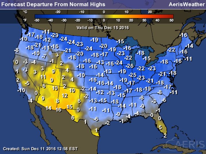
High Temperatures From Average Thursday
__________________________________________________________________________
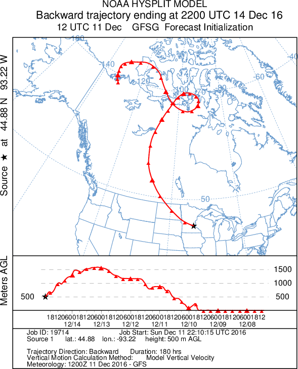
Backwards Trajectory Model
____________________________________________________________________________
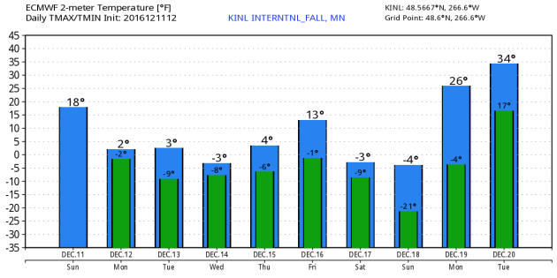
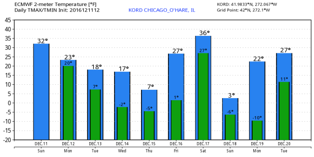
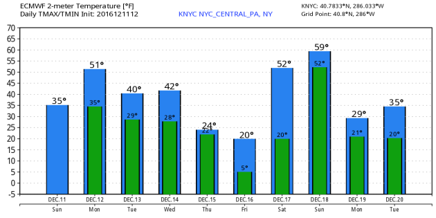
Extended Outlook for KINL - KORD - KNYC
Take a look at the extended outlook for International Falls, MN - Chicago, IL - New York, NY - which shows colder temperatures through the week ahead. Note the forecast for International Falls, MN shows high temperatures below zero. This secondary surge of Arctic air is also evident in Chicago, IL as temperatures dip into the teens and possibly even into the single digits. Even though the air mass will be modified later next week, you can still see a drop in temps for New York, NY in the 20s by the end of next week.
____________________________________________________________________________
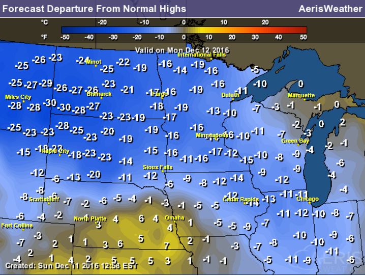
Here's an obligatory high temperature from average map for Thursday, December 15th, which shows that the eastern half of the nation will be nearly 10F to 25F below average. This will be the second Arctic air mass to impact much of the nation, one that will likely bring more heavy lake effect snow to the Great Lakes Region.
________________________________________________________________________
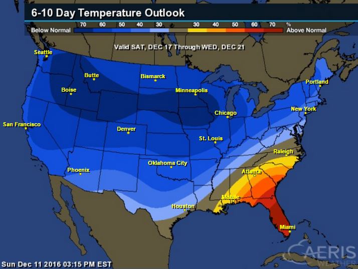
8 to 14 Day Temperature Outlook
According to NOAA's Climate Prediction Center, the 6 to 10 day temperature outlook suggests that colder than average temperatures will be with much of us across the nation from December 17th - 21st. It appears that the Arctic flood gates are open and there's no stopping it as we head past the half-way point of the month.
__________________________________________________________________________
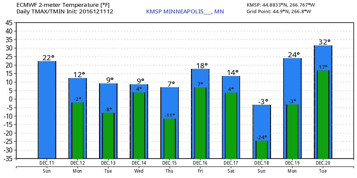
Here's an interesting look at the Extended forecast for Minneapolis and the backwards trajectory of the air mass that will be in place by Wednesday, December 14th in Minnesota. Note that the origins are traced back directly from the Arctic!
____________________________________________________________________________
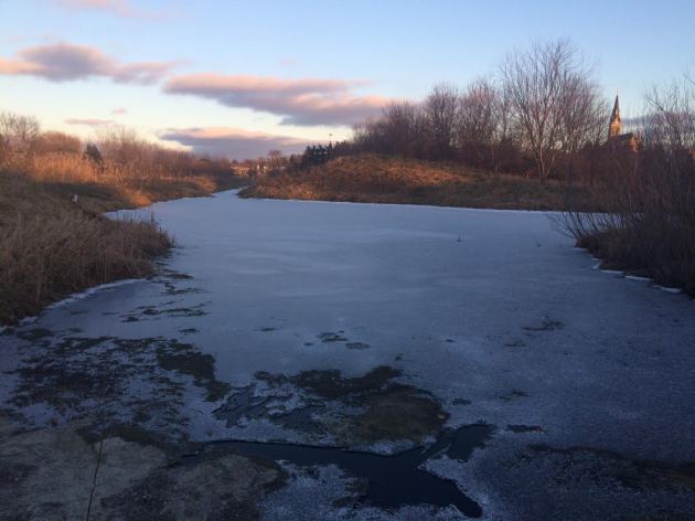
Ice Safety
Ice beginning to form on area lakes and ponds, but it is important to remember that the ice is NOT safe yet! We need several more days/weeks of this colder weather before you can even attempt to get out there... Here are a few tips from the MN DNR regarding ice safety:
Did you know?
New ice is usually stronger than old ice. Four inches of clear, newly‑formed ice may support one person on foot, while a foot or more of old, partially‑thawed ice may not.
Ice seldom freezes uniformly. It may be a foot thick in one location and only an inch or two just a few feet away.
Ice formed over flowing water and currents is often dangerous. This is especially true near streams, bridges and culverts. Also, the ice on outside river bends is usually weaker due to the undermining effects of the faster current.
The insulating effect of snow slows down the freezing process. The extra weight also reduces how much weight the ice sheet can support. Also, ice near shore can be weaker than ice that is farther out.
Booming and cracking ice isn't necessarily dangerous. It only means that the ice is expanding and contracting as the temperature changes.
Schools of fish or flocks of waterfowl can also adversely affect the relative safety of ice.The movement of fish can bring warm water up from the bottom of the lake. In the past, this has opened holes in the ice causing snowmobiles and cars to break through.
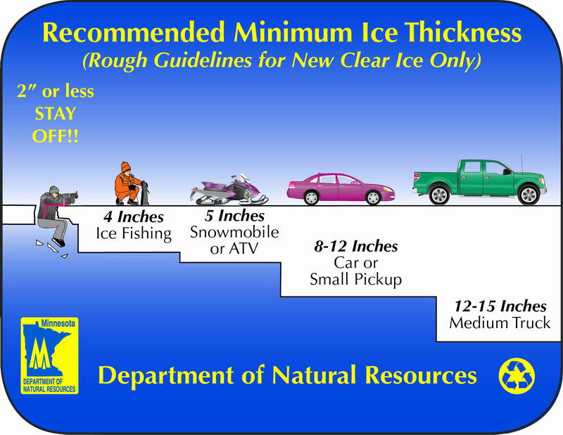
Remember that no ice is ever 100% safe, but here is the recommended ice thickness as the colder winter weather settles in. Note that to safely walk on ice, you need at least 4" of ice. Small cars and trucks need close to a foot of ice or more before you can even think about going out.
_________________________________________________________________________
84-Hour Outlook
Here's the national weather outlook through AM Thursday, which shows fairly quiet conditions across the country when it comes to precipitation. One storm system leaves the eastern US with heavy lake effect snow in the wake of an Arctic front that blows through and another Pacific storm blows into the Western US. This is the next storm late week that could bring another round of heavy snow to parts of the US into next weekend.
.gif)
10-Day Snowfall Outlook
Here's the 10 day snowfall potential, which shows the latest storm system moving through the northeastern US with pockets of heavy snowfall in the Northern New England States. The next storm system moves into Western US by the middle part of the week, which could translate into heavier snow across the Midwest, Great Lakes and parts of the Northeast later this week and weekend ahead.
Here's the 10 day snowfall potential, which shows the latest storm system moving through the northeastern US with pockets of heavy snowfall in the Northern New England States. The next storm system moves into Western US by the middle part of the week, which could translate into heavier snow across the Midwest, Great Lakes and parts of the Northeast later this week and weekend ahead.
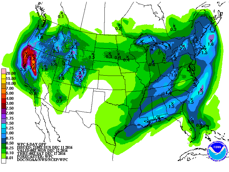
5 Day Precipitation Outlook
According to NOAA's WPC, the 5 day precipitation outlook suggests heavy precipitation continuing in the Western US, especially along the coast in the higher elevations. Some spots across central and northern California could see 3" to 6"+ of liquid precipitation. There will also be fairly decent liquid tallies in the eastern US with some spots seeing up to 1"+ through the end of the week.
 _____________________________________________________________________________
After a few vigorous tugs, I finally got the snow blower fired up. It's always a little sluggish to turn over the first time each season. Now my coat and boots smell like gasoline.
This weekend's snow was a good one, the kind that doesn't take much to shovel because it is so fluffy. Temperatures during much of the snow event were in the teens making it a near 20 to 1 ratio. Meaning that for every inch of water, you'd get 20 inches of snow. Those ratios are typical with fast-moving clipper systems in January.
The wintry carousel continues as another surge of Arctic settles into the region. This will be some of the coldest weather we've seen since February with highs in the single digits and overnight lows in the sub-zero range. Wind chill values across parts of the state may even dip into the 20s below zero by midweek.
Extended models are hinting at the potential of another plowable snow event by Friday. We're still too far out to talk totals, but keep the shovels handy. We've certainly settled into a more active wintry pattern.
___________________________________________________
Extended Weather Outlook
SUNDAY NIGHT: Flurries end early. Winds: ENE 5. Low: 5.
MONDAY: Arctic front arrives late. Light snow possible late. Winds: WNW 5-10. High: 12.
MONDAY NIGHT: Lingering flurries early. Turning colder. Winds: WNW 5-10. Low: -4.
TUESDAY: Bitter cold settles in. Winds: WSW 10-15. High: 7.
WEDNESDAY: Partly cloudy. Face-numbing wind. Winds: W 10-15. Wake-up: -2. High: 6.
THURSDAY: Icy sunshine. Winds: W 5-10. Wake-up: -7. High: 6.
FRIDAY: Another PM plowable snow event? Winds: SE 10-15. Wake-up: -3. High: 15.
SATURDAY: Lingering snow early. Turning colder. Winds:NNW 10-20. Wake-up: 6. High: 14.
SUNDAY: Another cold blast. Winds: SW 5. Wake-up: -5. High: 7
_______________________________
_______________________________
This Day in Weather History
December 12th:
2004: A strong cold front pushes through Minnesota during the early morning hours. By dawn, winds turn to the northwest and increase to 25 to 40 MPH with gusts as high as 70 MPH. The windiest part of the day was from mid morning through mid afternoon when many locations suffered sustained winds in the 30 to 45 MPH range. The highest wind gusts recorded in southern Minnesota during this time included 71 MPH in Welch and 62 MPH near Albert Lea, St. James, Winthrop and Owatonna. Other notable wind gusts included 59 MPH at New Ulm, 58 MPH in Mankato, 55 MPH in St. Cloud and Morris, 54 MPH at Redwood Falls, and 52 MPH at the Minneapolis/St. Paul International Airport. Scattered trees were downed and a few buildings received minor roof damage across the region.December 12th:
1939: A December gale along the North Shore leads to winds clocked at 48 mph at Duluth.
________________________________
Average High/Low for Minneapolis
December 12th
Average High: 28F (Record: 53F set in 1968)
Average Low: 13F (Record: -15F set in 1879)
Average Low: 13F (Record: -15F set in 1879)
Record Snowfall: 4.6" set in 1941
_________________________________
_________________________________
Sunrise/Sunset Times for Minneapolis
December 12th
December 12th
Sunrise: 7:42am
Sunset: 4:32pm
Sunset: 4:32pm
*Daylight Lost Since Yesterday: ~43sec
*Daylight Lost Since Summer Solstice: ~6hours and 48mins
______________________________________________________________________
*Daylight Lost Since Summer Solstice: ~6hours and 48mins
______________________________________________________________________
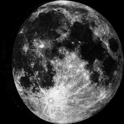
Moon Phase for December 11th at Midnight
2.7 Days Until Full (Cold) Moon
2.7 Days Until Full (Cold) Moon
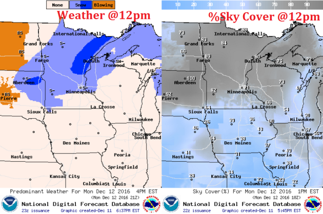
Weather Outlook Monday
High temperatures on MOnday
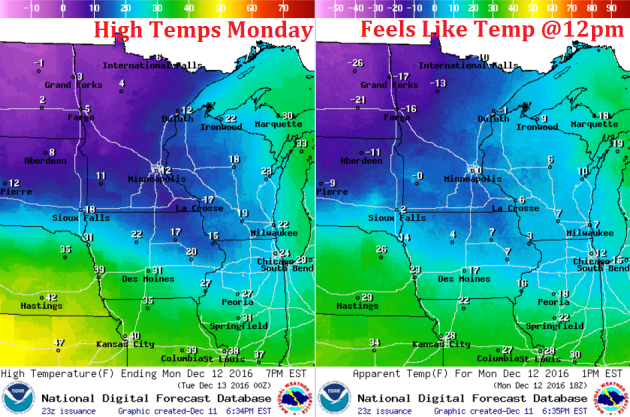
High Temperatures From Average MOnday
Here's a look at high temperatures from average on Monday
Weather Outlook Monday
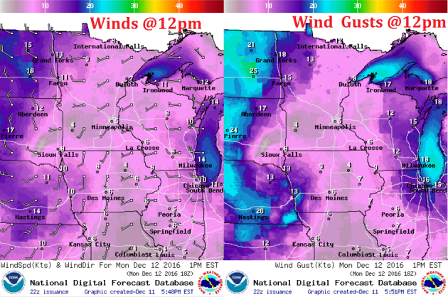
Winds will be very strong across the state again on Monday
Weather Outlook Monday
The weather outlook for Monday
___________________________________________________________
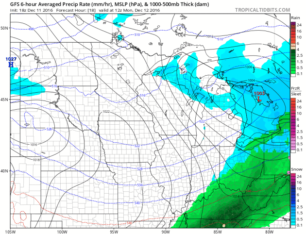
Somewhat Active Pattern With Colder Temps Ahead.
Here's the weather outlook through Sunday, which shows relatively quiet conditions this week (other than the Arctic air). The next thing we'll have to watch for is the snow potential by then end of the week. Stay tuned!
__________________________________________________________________________
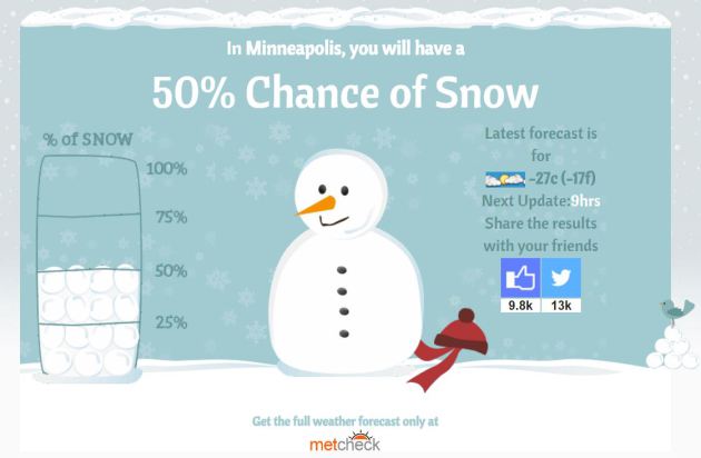
Will I Get A White Christmas?
Here's a neat website from MetCheck that tells you if you'll get a white Christmas. I typed in Minneapolis and it said there's a 50% chance!
Check it out HERE:

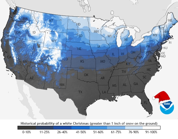
 White Christmas Probabilities
Are you wondering what your average probability is of a white Christmas? Here's a look from NOAA. Note that the bright white colors indicate a near 9 out of ever 10 Christmases in white, which means that there is at least 1" of snow on the ground on December 25th.
See mroe from NOAA HERE:
Here's a neat website from MetCheck that tells you if you'll get a white Christmas. I typed in Minneapolis and it said there's a 50% chance!
Check it out HERE:
Are you wondering what your average probability is of a white Christmas? Here's a look from NOAA. Note that the bright white colors indicate a near 9 out of ever 10 Christmases in white, which means that there is at least 1" of snow on the ground on December 25th.
See mroe from NOAA HERE:
________________________________________________________________________________
Thanks for checking in and don't forget to follow me on Twitter @TNelsonWX

No comments:
Post a Comment