-15 F. wake-up temperature at St. Cloud yesterday.
12 F. maximum temperature yesterday in St. Cloud.
21 F. average high on January 8.
32 F. high in the cities on January 8, 2016.
January 9, 1982:
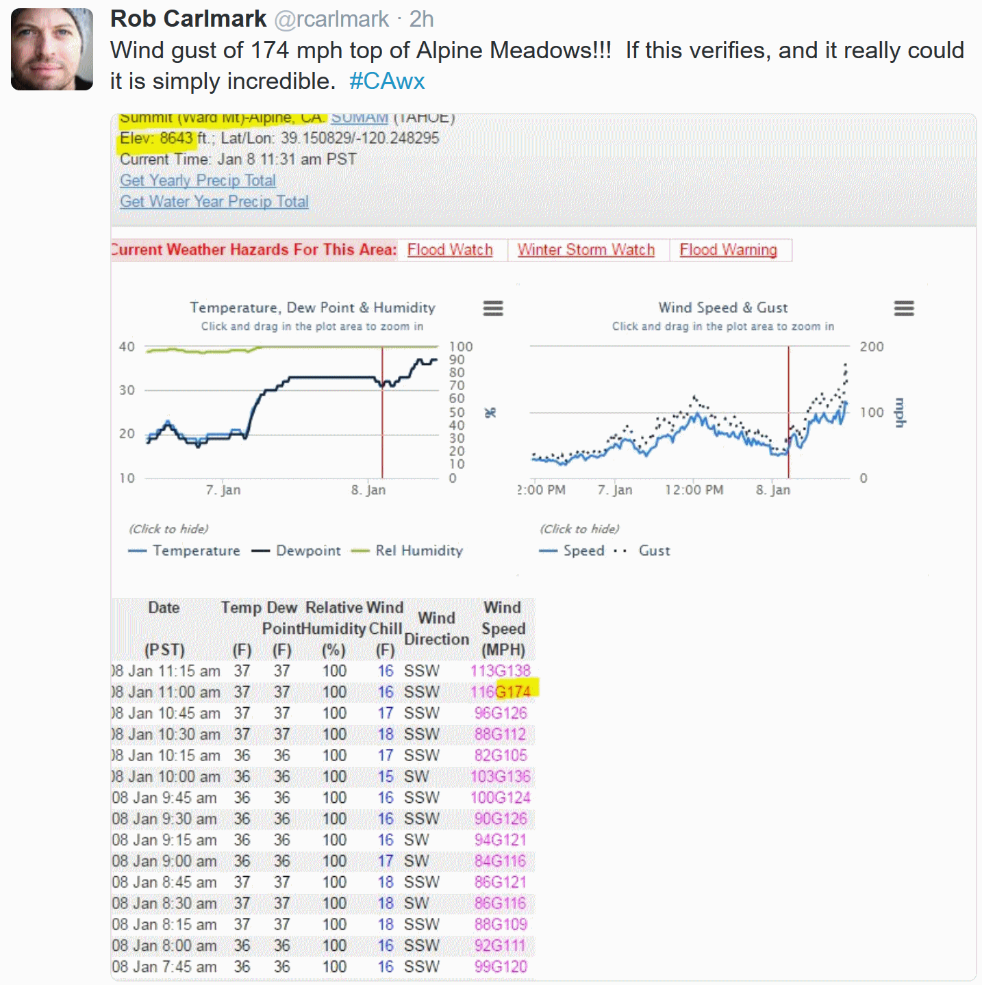
Both January 9th and 10th would have some of the coldest windchills
ever seen in Minnesota. Temperatures of -30 and winds of 40 mph were
reported in Northern Minnesota. This would translate to windchills of
-71 with the new windchill formula, and -100 with the old formula.
January 9, 1934:
A sleet and ice storm hits southwest Minnesota. Hardest hit locations
were Slayton, Tracy and Pipestone. The thickest ice was just east of
Pipestone with ice measuring 6 to 8 inches in diameter. At Holland in
Pipestone County three strands of #6 wire measured 4.5 inches in
diameter and weighed 33 ounces per foot. The ice was described as: 'Very
peculiar information being practically round on three sides, the lower
side being ragged projectiles like icicles: in other words pointed. The
frost and ice were wet, not flaky like frost usually is. In handling
this, it could be squeezed into a ball and did not crumble.'
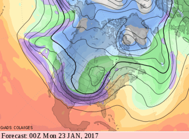
 Arctic Air Fades - A Real January Thaw Brewing
"What
good is the warmth of summer, without the cold of winter to give it
sweetness" wrote John Steinbeck. Good point. These cold fronts give us
something to talk about, other than politics and the Vikings.
We're
coming out of a weak La Nina cooling phase in the Pacific Ocean, but
the maps almost look like something out of a powerful El Nino warming
event: a conga-line of big, powerful storms battering the west coast and
a strong subtropical jet stream. You'll start to feel that milder,
Pacific influence in coming days: 20s today &
Tuesday; 30s one week from today with a little drizzle. NOAA's GFS model predicts 40s
in 2 weeks. We'll see, but after one more (brief/fleeting) swipe of cold air later this week we enjoy a real January Thaw.
A slow-moving storm tracking into the Midwest may drop a few inches of snow between
tonight and
Wednesday; potentially plowable in some areas (at least 2 or 3 inches). After a numbing
Friday temperatures finally recover next week.
If anyone asks - the coldest day of winter at MSP is
January 15.
After that, average temperatures start to rise again. High five!
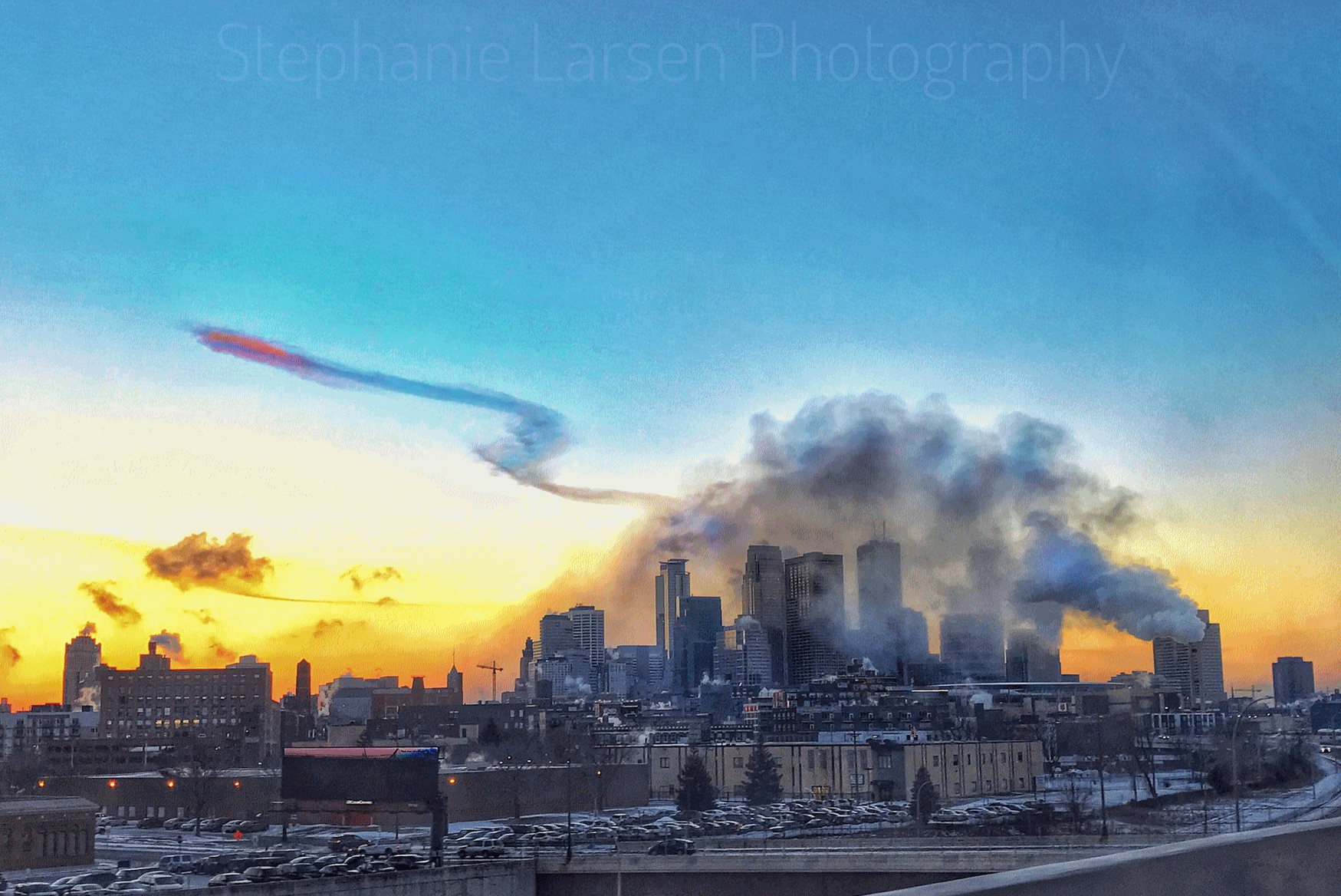
Photo credit:
Stephanie Larsen Photography.
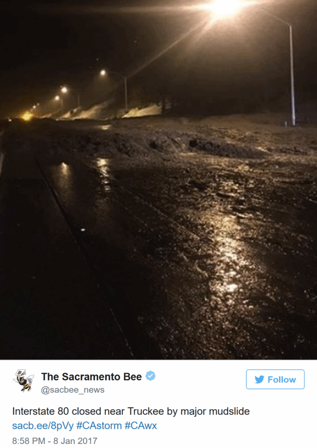
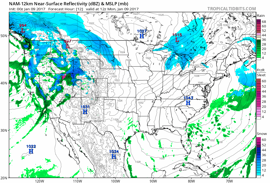 Major Western Storm
.
NOAA's 12 KM NAM guidance shows the Pacific storm pushing heavy rain
and snow inland, and down the coast toward L.A. today. An area of low
pressure tracking across the Midwest pushes an icy mix across the
Dakotas and Minnesota, rain (green) across the Great Lakes, Ohio Valley
and much of the east coast by Thursday. Animation: Tropicaltidbits.com.
Ongoing Coverage of West Coast Storm Impacts.
Mercury News
has a stream of tweets and posts focused on not only the Bay Area, but
the entire west coast, tracking flooding, mudslides, power outages and
travel disruptions.
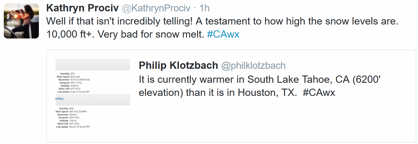
Perspective on the atmospheric rivers creating the ongoing flood scenario for California and much of the west coast from
Climate Signals.
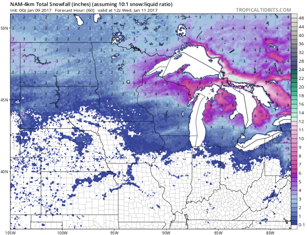
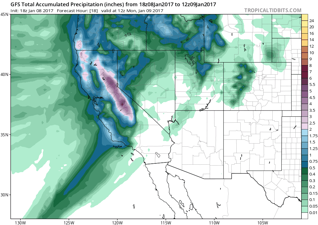 Multiple Waves of Heavy Rain for California
.
GFS guidance continues to print out an additional 5-15" of liquid
moisture for much of central and northern California over the next 2
weeks. Los Angeles and San Diego will see some rain, but the real
disruptions will take place over NoCal in the coming days. 384-hour
accumulated precipitation product: NOAA and Tropicaltidbits.com.
Almost Plowable.
Models suggest a period of ice Monday night, which would keep any
snowfall totals down. A couple inches of accumulation between today and
Wednesday night seems realistic, then drying out and much colder by
Thursday and Friday.
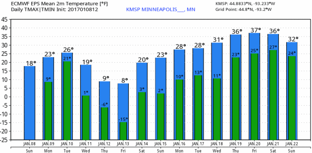
Suitable for Framing.
Here in the Land of Low Weather Expectations we get pretty excited
about 30s in mid-January. In fact we're happy to see temperatures above
zero the next week or so, often the coldest stretch of the entire year.
30s by the end of next week seem likely, according to ECMWF data.
Graphic: WeatherBell.
Stormy Trough by Late Week.
Temperatures warm up into the 30s 1-2 weeks from now, but NOAA's GFS
model carves out a broad mid-latitude trough of low pressure over the
central USA, capable of spinning up a few formidable storms; maybe a mix
changing to heavy snow from Denver to the Twin Cities? No, spring is
not right around the corner.
30s - Outside Shot at 40s?
Here is raw GFS data, which may be overly generous in the temperature
department. I doubt we'll see 50 degrees, but a couple days above 40F.
Quite possible roughly 2 weeks from today.
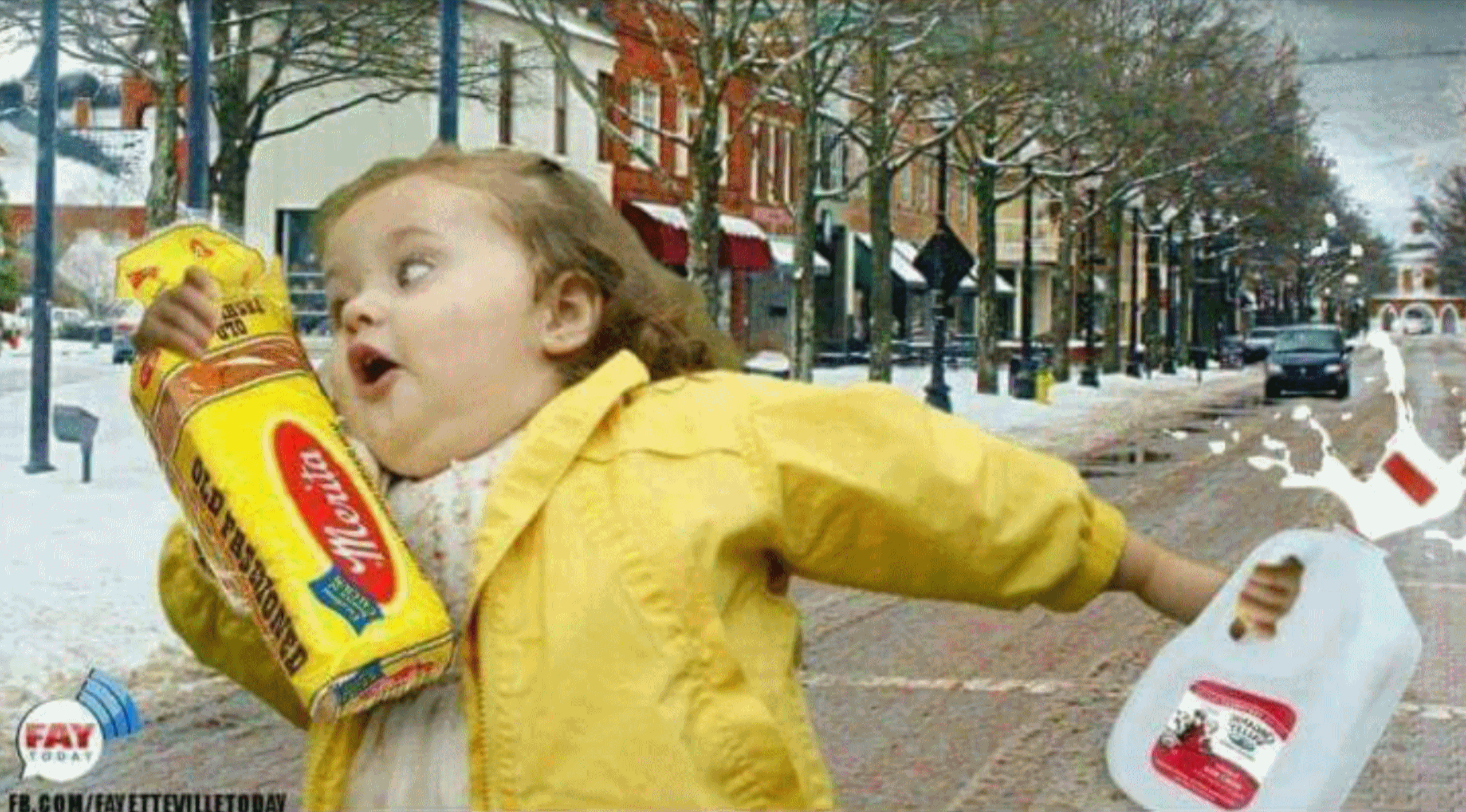 The Science Behind Why People Buy Bread When Snow Is In The Forecast
. Here's an excerpt of a good explanation from Dr. Marshall Shepherd at
Forbes: "...
In the article The Psychology of Stockpiling,
Laurie Dove actually explored aspects of this question too. She quoted
Psychologist Lisa Brateman who pointed out, "the thought to get milk
before a storm is followed by the action or compulsion to go out and
stockpile it. In one way or another, we spend a lot of time and energy
trying to feel in control, and buying things you might throw out still
gives the person a sense of control in an uncontrollable situation." I
interpret from Dove's logic that buying perishable items may convey that
there is a sense of "temporary inconvenience" that can be endured as
opposed to buying more durable items like canned goods that would
signify a more traumatic situation. This argument suggests that
psychological coping or control of some sort is at play..."
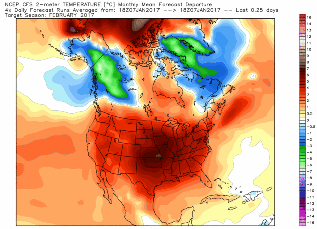
Place Your Bets.
January may wind up colder than average for much of the USA, certainly
the northern third of America. Will the atmosphere compensate with a
warmer than normal February? Saturday's CFSv2 (Climate Forecast System)
solution looks toasty for most of the Lower 48. But the model has been
flip-flopping between mild and cold solutions in recent weeks, so
confidence levels are still very low. Updated map: WeatherBell.
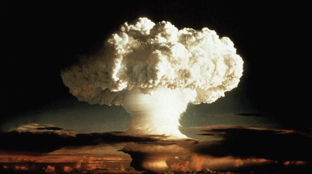
Bill Perry is Terrified. Why Aren't You? It
only takes one nuke going off somewhere - anywhere - to radically
change all of our lives, according to Bill Perry in a sobering interview
at
POLITICO Magazine: "...
Nuclear
bombs are an area of expertise Perry had assumed would be largely
obsolete by now, seven decades after Hiroshima, a quarter-century after
the fall of the Soviet Union, and in the flickering light of his own
life. Instead, nukes are suddenly—insanely, by Perry’s estimate—once
again a contemporary nightmare, and an emphatically ascendant one. At
the dawn of 2017, there is a Russian president making bellicose boasts
about his modernized arsenal. There is an American president-elect who
breezily free-associates on Twitter about starting a new nuclear arms
race. Decades of cooperation between the two nations on arms control is
nearly at a standstill. And, unlike the original Cold War, this time
there is a world of busy fanatics excited by the prospect of a planet
with more bombs—people who have already demonstrated the desire to
slaughter many thousands of people in an instant, and are zealously
pursuing ever more deadly means to do so..."
File photo credit:
New York Times. "
The mushroom cloud of the "Ivy Mike" hydrogen bomb test by the United States on Enewetak, an atoll in the Pacific Ocean, in 1952." Credit Department of Defense Nuclear Information Analysis, via Reuters.
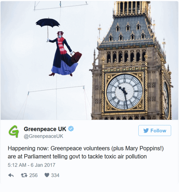
London Takes 5 Days to Breach 2017 Air Pollution Limit.
The Washington Post explains: "
It
was a powerful image: soaring high in the sky next to Big Ben was a
Mary Poppins figure wearing a protective mask. And for good reason:
London exceeded its annual air pollution limits for the whole of 2017 on
Thursday night — a whopping five days into the new year. London is a
world leader in nitrogen dioxide (NO2) -- levels are far higher than
they are in the U.S. -- because of its reliance on diesel-powered
vehicles. Many of the city’s iconic black cabs and double-decker buses
are run on diesel, a major source of NO2..."
The Ugly Unethical Underside of Silicon Valley. Erin Griffith has a must-read article at
Fortune; here's a snippet: "...
No
industry is immune to fraud, and the hotter the business, the more
hucksters flock to it. But Silicon Valley has always seen itself as the
virtuous outlier, a place where altruistic nerds tolerate capitalism in
order to make the world a better place. Suddenly the Valley looks as
crooked and greedy as the rest of the business world. And the growing
roster of scandal-tainted startups share a theme. Faking it, from
marketing exaggerations to outright fraud, feels more prevalent than
ever—so much so that it’s time to ask whether startup culture itself is
becoming a problem..." (Illustration: Alconic for Fortune).
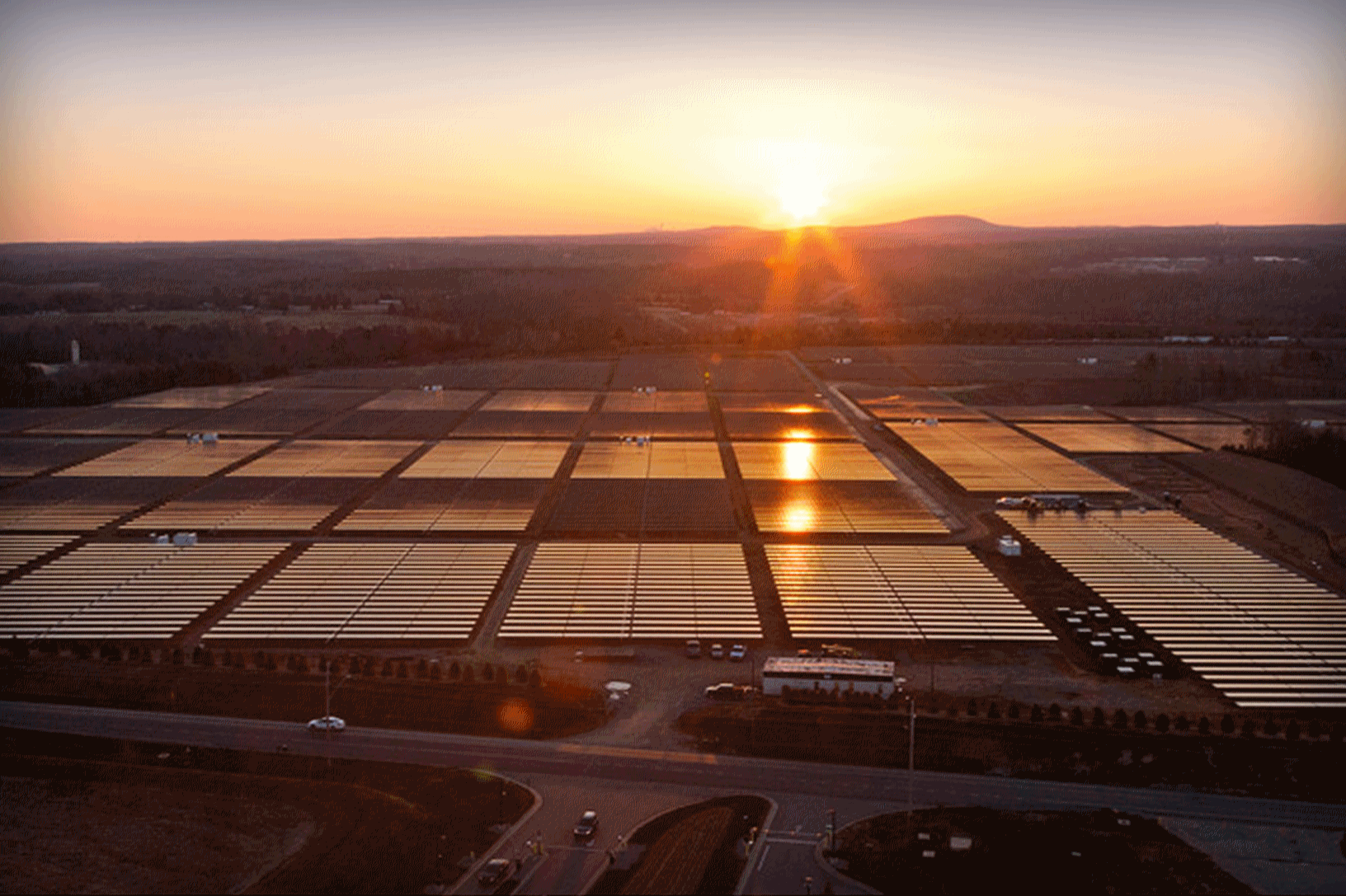 Solar Could Beat Coal to Become the Cheapest Power on Earth
. Here's a clip from
Bloomberg: "
Solar
power is now cheaper than coal in some parts of the world. In less than
a decade, it’s likely to be the lowest-cost option almost everywhere.
In 2016, countries from Chile to the United Arab Emirates
broke records with deals to generate electricity from sunshine for less
than 3 cents a kilowatt-hour, half the average global cost of coal
power. Now, Saudi Arabia,
Jordan and Mexico are planning auctions and tenders for this year,
aiming to drop prices even further. Taking advantage: Companies such as
Italy’s Enel SpA and Dublin’s Mainstream Renewable Power,
who gained experienced in Europe and now seek new markets abroad as
subsidies dry up at home. Since 2009, solar prices are down 62 percent,
with every part of the supply chain trimming costs..." (File photo: Apple).
Your Car Wants To Say Hello. And That's Only The Start. Is this what we can look forward to in a few years?
The Washington Post reports: "
Toyota’s
empathetic car of the future is there for you. You’ve had a frustrating
day at work; it plays soft music and lowers the temperature. You’re
lost in an unfamiliar neighborhood; it offers to take over the driving.
You start to nod off at the wheel; it taps you on the shoulder and
starts up a conversation. This unconventional interplay between the
driver and automobile is central to concept cars that Honda and Toyota
unveiled at the annual CES technology conference in Las Vegas this week.
In the not-so-distant future, vehicles will not only be safer or more
efficient. They will be our companion, watching our every move..."
Photo credit: "
The
Concept-i from Toyota showcases what the company expects cars will look
like in 2030. It was revealed on Wednesday at CES in Las Vegas." (Courtesy of Toyota)
This Is The World's Most Expensive City for Expatriates. An $8 cup of coffee?
TIME reports: "
An annual report
by global consultancy firm Mercer has declared Hong Kong as the world’s
most expensive city for expatriates to live in. The survey of 209
cities took into account the cost of scores of items in each
destination, including housing, food and entertainment. Mercer found
that an unfurnished two-bedroom apartment in a decent neighborhood of
Hong Kong rented for over $6,800 a month, compared to roughly $4,600 in
London and just $4,000 in Tokyo. A cup of coffee cost nearly $8 in Hong
Kong — twice as much as London ($4.40) and Tokyo ($4.00) respectively..." (Photo credit
here).
Math Says This Is The Perfect Age To Get Married. Between age 100 and 105. Just a hunch. Sure it's clickbait but I couldn't resist; here's an excerpt from
Motto: "
A
study suggests that people should get married between the ages of 28
and 32 if they don’t want to get divorced, at least in the first five
years. Before we proceed to the explanation: Don’t shoot me if you’re
older than that and not married yet. These are just statistics and can
in no way account for your personal situation, or that last
cheater/psycho/narcissist you wasted 18 months on. Nobody’s blaming you.
You are a wonderful and entirely loveable person. Now, moving on. The study
was done by Nick Wolfinger, a sociologist at the University of Utah,
and published by the generally pro-marriage Institute of Family Studies.
It suggests that people who get married between 28 and 32 split up
least in the ensuing years..."
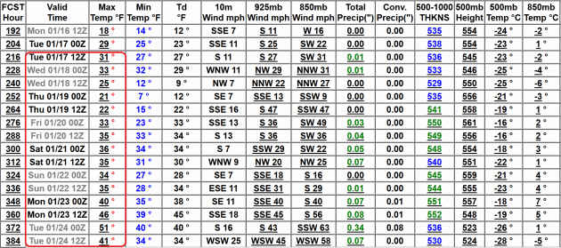
MONDAY: Light snow, slick roads. Winds: SE 5-10. High: 22
MONDAY NIGHT: Light snow - couple inches possible. Low: 21
TUESDAY: Snow tapers, turning colder. Winds: NW 10-20. High: 29
WEDNESDAY: More light snow streaks in. Winds: NW 8-13. Wake-up: 8. High: 14
THURSDAY: Lot's of clouds, feels like -10F. Winds: NW 10-20. Wake-up: 4. High: 11
FRIDAY: Yukon sleepover. Light winds. Winds: NW 5-10. Wake-up: -7. High: 5
SATURDAY: Partly sunny, temperatures recover. Winds: NW 5-10. Wake-up: 0. High: 21
SUNDAY: Fading sun, above average temps. Winds: SE 5-10. Wake-up: 11. High: 28
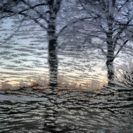
Photo credit: Imara Hixon.
Climate Stories...
11 Ways to See How Climate Change is Imperiling the Arctic. National Geographic has a long, convincing look at the rapid changes underway at the top of the world: "...
While
the average temperature of the planet is slowly creeping up, the Arctic
is warming far more quickly—as much as two to three times faster. On
December 22, a weather buoy near the North Pole reported temperatures at the melting point
of 32 degrees Fahrenheit. And recent research suggests that the average
summer temperature in the region over the last century is higher than
in any other century for at least 44,000 years.
Maps and visualizations of the resulting changes in the Arctic make it
clear that global warming is no hoax. Scientists are getting a vastly
improved picture of what is happening in the Arctic today as sea-ice
extent, thickness, and volume are tracked by satellites, ocean buoys,
and submarines with upward-looking sonar. The measurements show that the
Arctic keeps breaking records for rising temperatures and declining ice
cover..."
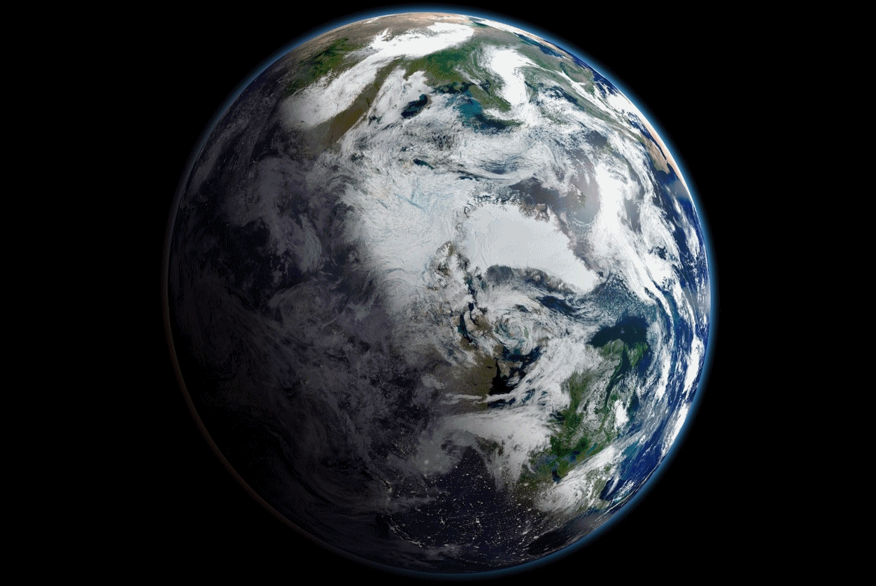
Image credit: "
On
September 16, 2012, Arctic sea ice extent was at its lowest level since
satellite monitoring began in 1979. This view of Earth, centered on the
Arctic, is a mosaic of images taken on September 2, 2012 by NASA’s
Suomi-NPP satellite." Photo courtesy of NASA.
More information on NASA's Suomi NPP satellite platform here.
Bill Nye Heading to Netflix To Take on Climate Deniers. Here's an excerpt from Grist: "Bill
Nye is heading to Netflix to take on climate change deniers — with help
from a supermodel. Nye first found television fame in the ’90s with his
weekly children’s show on PBS. Now, he’s returning to the small screen —
or, at least, the streaming device — with Bill Nye Saves the World, a
Netflix series set to debut this spring. “Each episode will tackle a
topic from a scientific point of view,” Nye said in a statement,
“dispelling myths, and refuting anti-scientific claims that may be
espoused by politicians, religious leaders, or titans of
industry.” Those topics include some hot-button issues, like
vaccinations, genetically modified foods, and climate change..."
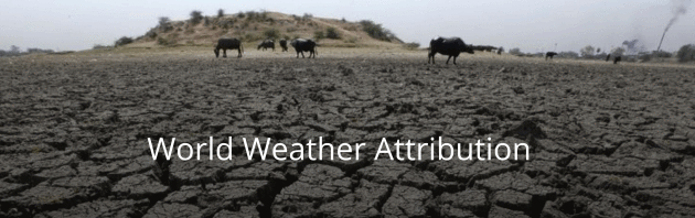
As Earth Gets Hotter, Scientists Break New Ground Linking Climate Change to Extreme Weather. Here's an excerpt of a post at
Environmental Defense Fund: "...
The World Weather Attribution
project, an international effort “to sharpen and accelerate the
scientific community’s ability to analyze and communicate the possible
influence of climate change on extreme-weather events,” now conducts
initial analyses in near real time. In 2016, this project covered the
March coral bleaching in the Pacific Ocean, the May European rain
storms, the August Louisiana floods, the extreme Arctic warming during
November and December, and the December cold air outbreak over the
United States – all significant weather events. In four of the five
events, scientists found links to human-caused climate change, with the
December cold air outbreak being the only event without a discernible
human fingerprint..."
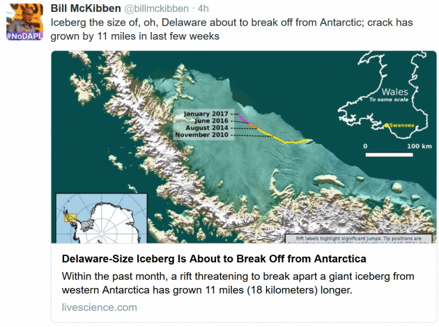
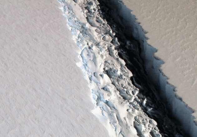
Large Iceberg Poised to Break Off from Antarctica. This may be a REALLY big iceberg, as reported by Climate Central: "A
rift that has been wending its way across Antarctica’s massive Larsen C
ice shelf just made another leap forward, growing by more than 10
miles, scientists monitoring it reported Thursday. Now, a chunk of ice
bigger than New York's Long Island is hanging on by a relative thread.
When it breaks off — possibly very soon — it could put the ice shelf in a
more precarious position that could eventually lead it to disintegrate.
That could contribute further to the global sea level rise
that is threatening the many populous cities that lie within a few
miles of the world’s coasts. “This event will fundamentally change the
landscape of the Antarctic Peninsula,” the scientists at Project MIDAS,
an Antarctic research effort that has been watching the rift closely, wrote in update..."
Photo credit: "
A
large rift in Antarctica's Larsen C ice shelf, photographed by NASA's
IceBridge mission on Nov. 10, 2016. The rift surged ahead by about 10
miles in late December." Credit: NASA/John Sonntag


No comments:
Post a Comment