Northern Lights
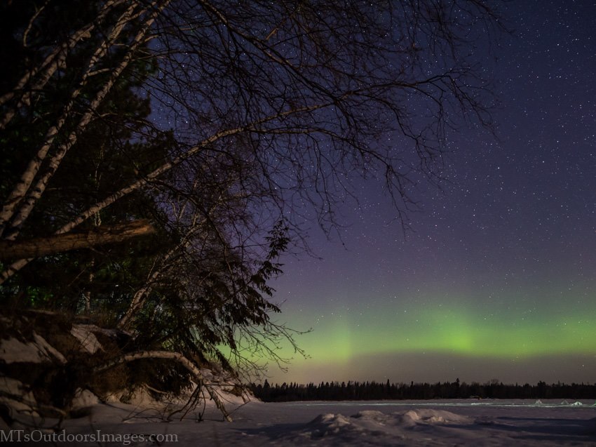
Thanks to Michael Thompson for the picture below who snapped this beautiful shot from Kabekona lake, Paul Bunyan State Forest, North central Minnesota on February 16th.
Northern Lights Forecast
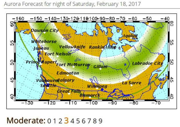
According to the Geophysical Institute at the University of Alaska Fairbanks, there is still a chance of northern lights Saturday Night.
"Forecast: Auroral activity will be moderate. Weather permitting, moderate displays will be visible overhead from Inuvik, Yellowknife, Rankin, and Igaluit to as far south as Whitehorse, Ft. McMurray, James Bay and visible low on the horizon as far south as Prince Rupert, Calgary, Minot, Bemidji, Stevens Point, Traverse City and Quebec City, Canada."
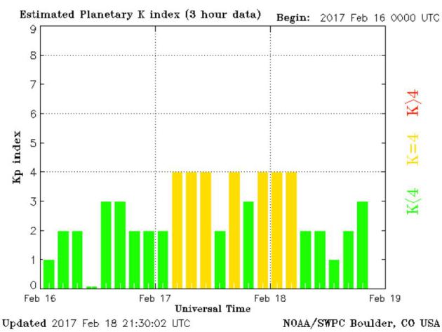
Planetary K Index
Here's the Planetary K Index over the last several days, which shows a slight increase from the 17th and 18th. This indicates when northern lights were a little more active and just enough to see them close to home.
_____________________________________________________________________
Early Spring Across the State
Here's the view from Downtown Duluth on Saturday afternoon where the temperature warmed into the lower 50s nearly 30 degrees above average! Warm weather looks to continue right through early next week, but scattered showers and rare February thunderstorms move into the area on Monday.
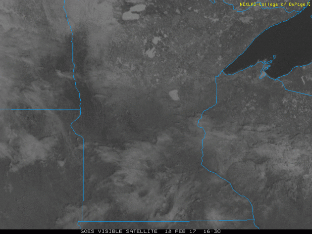
Visibile Satellite on Saturday
Despite a few more clouds across the region on Saturday, it was still a VERY warm day with highs in the 50s to near 60F. Mostly dry and near record breaking February warmth stays with us on Sunday before weather conditions sour on Monday. Once again, Minneapolis and St. Cloud warmed to record highs for February 18th:
Minneapolis High on Saturday, February 18th (58F) Tied previous 58F set in 1981.
St. Cloud High on Saturday, February 18th (57F) previous 56F set in 56F set in 1981.
St. Cloud High on Saturday, February 18th (57F) previous 56F set in 56F set in 1981.
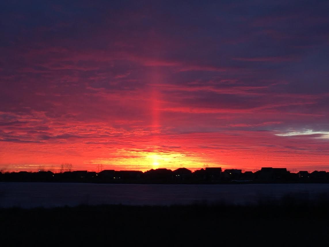
Saturday's Sun Pillar Sunset
It happened fast, but did you see Saturday's sunset? The line stretching up from the sun is called a sun pillar and forms when sunlight reflects off of ice crystals from high-level clouds.
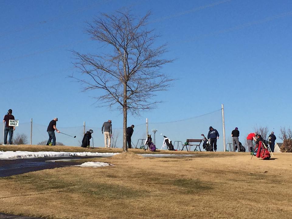
Yes, this weather is getting REALLY strange now. Not sure I can ever remember contemplating whether or not to make a tee time in February. Thanks to Cedar Creek Golf Course for the image below, who will be OPEN for golf this weekend... unreal!
(Image below courtesy: Cedar Creek Golf Course Facebook Page)
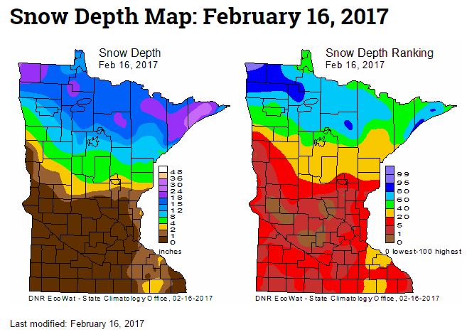
Snow Depth Ranking
The latest snow depth and ranking from the MN DNR shows that much of southern Minnesota is now snow free! However, much of extreme northern Minnesota still has nearly 12" or more of snow on the ground.
____________________________________________________________________________
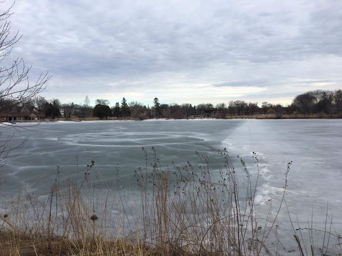
Ice Thinning Rapidly
Thanks to @DKayserWX for the picture below from Lake George in St. Cloud. Thanks to abnormally warm conditions over the past serveral days, ice conditions have been deteriorating rapidly. Several cars have been reported going through the ice on area lakes. Be extremely cautious if you venture out.
 _______________________________________________________________________________
Officials Warn of Thinning Ice Around Area Lakes
I feel cheated. I love winters in Minnesota and everything that comes along with it. Call me crazy, but I like the snows, I like the extreme cold temps and I love the winter sports. Unfortunately, this winter has been stunted. The coldest 3 months (on average) for the northern hemisphere, which is also known as Meteorological winter has been running well above average in the temperature department. Month by month here it is for the Twin Cities:
December: +1.2F above average
January: +5.3F above average
February (thru the 17th): +7.7F above average
January: +5.3F above average
February (thru the 17th): +7.7F above average
Because of that, official are warning of thin ice on area lakes. There have been several cars that have already gone through lakes, so angler should stay aware of their situation before heading out.

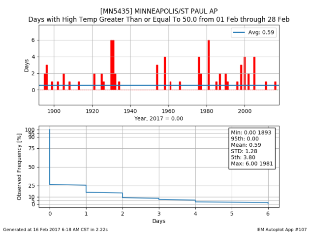
How Rare are 50F+ in February in the Twin Cities?
Take a look at the red lines below, this tells us how many times the Twin Cities has seen 50F or warmer since the late 1800s. Note that we've only had a maximum of 6 days and has happened only 3 times, in the 1930s and again in 1981. Note that the next 6 days are forecast to be at or greater than 50F!
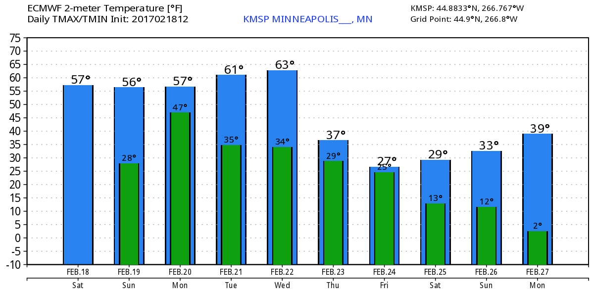
Here's the temperature outlook through February 27th, which shows well above average temperatures continuing through the weekend and into the middle part of next week. Note that Friday's high temperatures was the first time we've 50F and 60F in the Twin Cities since November 28th (55F) and November 16th (61F). This weekend will continue to feel very much like April with highs in the 50s to near 60 degrees! Unreal!
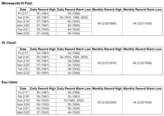
Record Warmth Continues...
Thanks to the National Weather Service for the numbers below, which tell us how high the record highs are from 2/16 to 2/22 in Minneapolis, St. Cloud and in Eau Claire. Note that several of these records have a chance at being beaten in the days to come. If you're a fan of this warmer weather during meteorological winter, enjoy!
Here are some number from the National Weather Service:
What is the record for consecutive days with highs of 50 degrees or higher in February?
Twin Cities: 6 days (1930 and 1981)
St. Cloud: 5 days (1981)
Eau Claire: 7 days (1930)
How often does the temperature reach 60 degrees or higher in February?
Twin Cities:
There have only been 4 days on record (back to 1873) when the temperature has reached 60 degrees or warmer in February (1896, 1921, 1981, 2000).
The earliest 60 degree reading on record is February 15th (1921).
St. Cloud:
There have been no days on record with a temperature of 60 degrees or warmer in February since temperature records began in St. Cloud in 1894.
The earliest 60 degree reading on record is March 3rd (1905).
______________________________________________________________________________
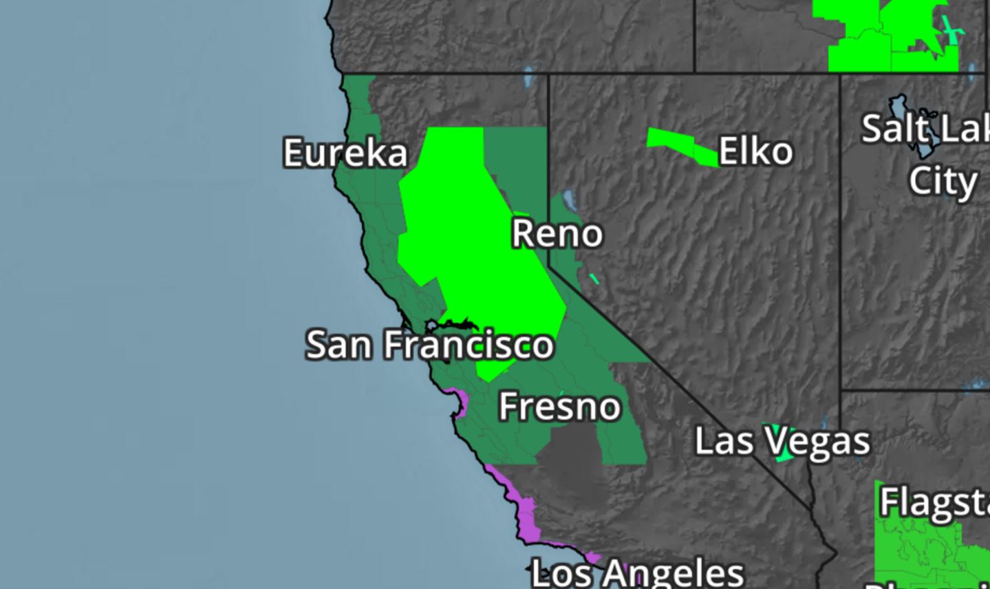
Widespread Record February Warmth Through Early Next Week
As temperatures warm later this week, record warmth could follow. The images below show where record warmth is forecast (circles) for Sunday, Monday and Tuesday. Note that by Friday, record warmth could stretch as far north as Minneapolis, MN, St. Cloud, MN, and Fargo, ND!
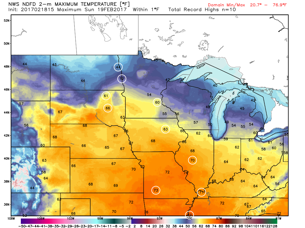
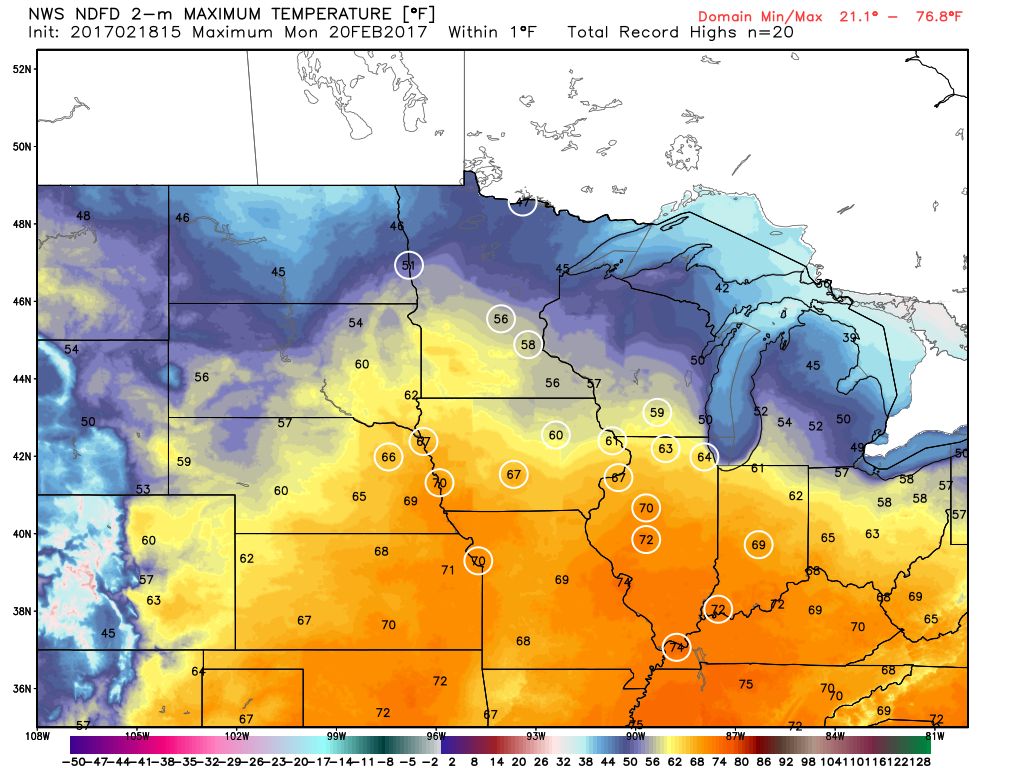
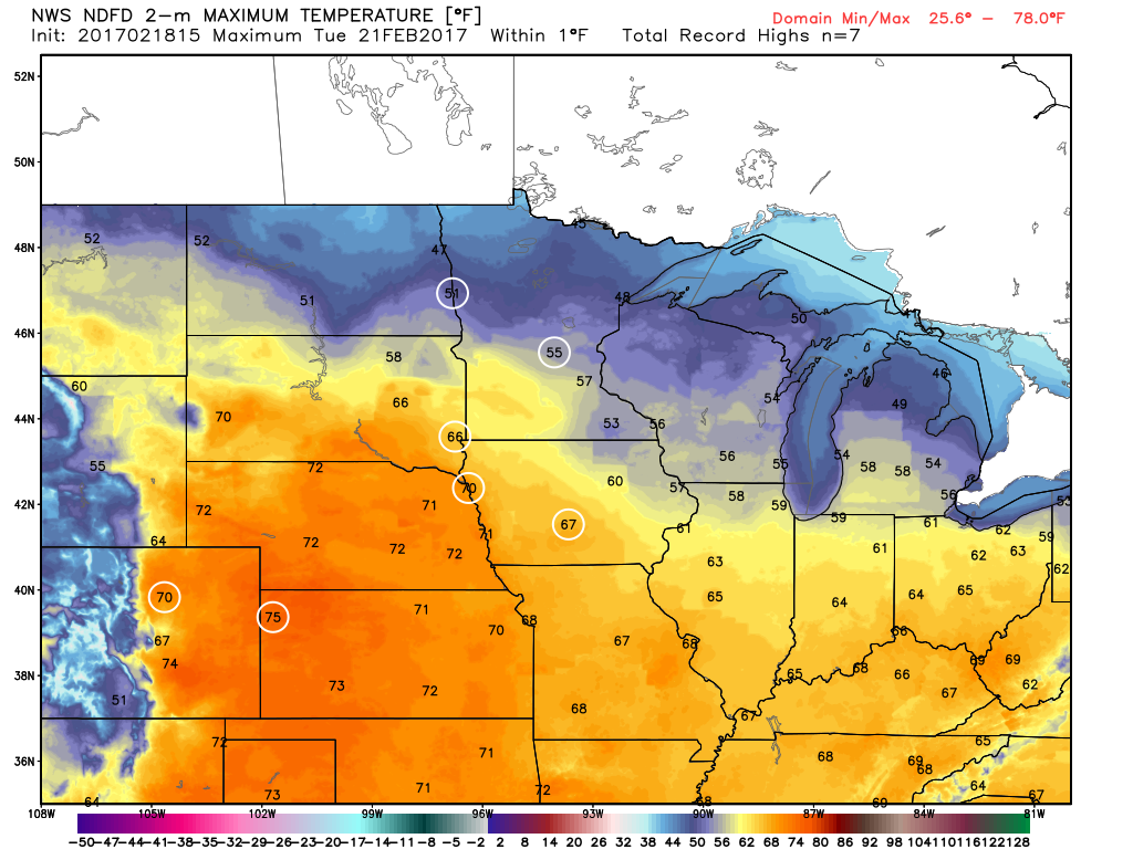
As temperatures warm later this week, record warmth could follow. The images below show where record warmth is forecast (circles) for Sunday, Monday and Tuesday. Note that by Friday, record warmth could stretch as far north as Minneapolis, MN, St. Cloud, MN, and Fargo, ND!
______________________________________________________________________________
Dazed and confused. Record February heat continues
By Todd Nelson, filling in for Douglas
By Todd Nelson, filling in for Douglas
I took advantage of this abnormally warm February weather and knocked a few things off the outdoor honey do list. Holiday lights put away, holiday decorations put away and cleaned the garage! I even gabbed to my neighbor for the first time in a few months. As much as I love winter weather and everything that comes along with it here in Minnesota, it's hard to not enjoy this record February warmth just a little bit.
Sunday will be another extremely mild day with highs bumping up close to 60 degrees across much of southern Minnesota. Record highs will likely fall again for many locations through early next week, before big changes arrive late next week. Long range weather models are still trying to latch onto plowable snowfall across parts of the Upper Midwest Thursday into Friday. It's still way too early to tell what the powerful Pacific storm will do when it plows through, but stay tuned.
In the meantime, enjoy the dry weather today. Monday brings scattered showers and rare February rumbles of thunder. We live in interesting times.
___________________________________________________________________________
___________________________________________________________________________
Extended Forecast:
SATURDAY NIGHT: More clouds, still mild. Winds: ESE 5. Low: 36.
SUNDAY: Another record high? More PM clouds. Showers develop overnight. Winds: SE 5-10. High: 58.
SUNDAY NIGHT: Chance of a few showers and a rumble of thunder late. Winds: SE 5-10. Low: 47.
MONDAY: Record warmth again. Breezy with scattered showers and rumbles. Winds: SSW 5-15. High: 59.
TUESDAY: Sun returns. Still feels like April. Winds: WSW 5. Wake-up: 41. High: 56.
WEDNESDAY: Stll nice. Last very warm day. Winds: W 5-10. Wake-up: 41. High: 56.
THURSDAY: Breezy. Rain/snow mix develops. Winds: NE 10-20. Wake-up: 36. High: 44.
FRIDAY: Windy. Increasing snow chance. Winds: NNW 15-25. Wake-up: 28. High: 34.
SATURDAY: February returns. Lingering flakes. Winds: WNW 5-10. Wake-up: 14. High: 28.
_______________________________________________________________________________
_______________________________________________________________________________
This Day in Weather History
February 19th
February 19th
1928: A dust storm moves across Minnesota, causing lights to be turned on in the daytime in the Twin Cities.
_______________________________________________________________________________
_______________________________________________________________________________
Average High/Low for Minneapolis
February 19th
February 19th
Average High: 30F (Record: 57F set in 1981)
Average: Low: 14F (Record: -20F set in 1941)
Average: Low: 14F (Record: -20F set in 1941)
*Record Snowfall: 8.3" set in 1952
_______________________________________________________________________________
_______________________________________________________________________________
Sunrise Sunset Times For Minneapolis
February 17th
February 17th
Sunrise: 7:07am
Sunset: 5:47pm
Sunset: 5:47pm
*Daylight Gained Since Yesterday: ~2 minutes & 59 seconds
*Daylight Gained Since Winter Solstice (December 21st): ~1 hour & 54 minutes
________________________________________________________________________________
*Daylight Gained Since Winter Solstice (December 21st): ~1 hour & 54 minutes
________________________________________________________________________________
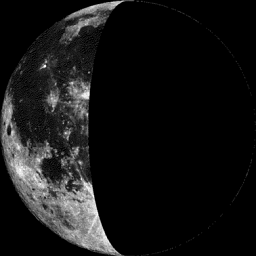
Moon Phase for February 16th at Midnight
0.5 Days After Last Quarter
0.5 Days After Last Quarter
________________________________________________________________________________
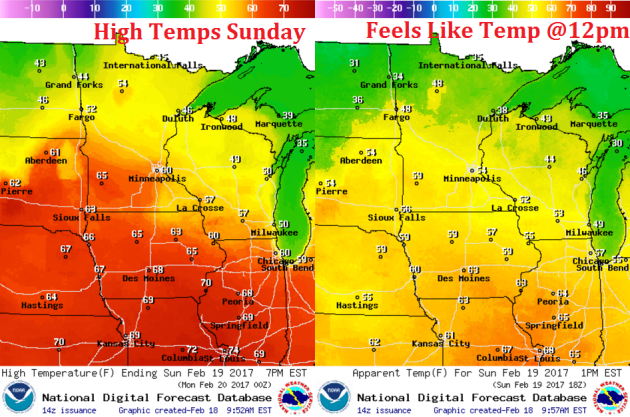
Weather Outlook For Sunday
High temperatures on Sunday will once again flirt with records across the region. Note that we have another shot at reaching record highs across the region on Sunday with reading in the 50s and 60s across the state.
Weather Outlook For Sunday
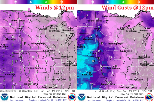
Winds will start to increase across the region on Sunday. Note that winds will be a little stronger across far western and southwestern Minnesota with gusts approaching 15mph or greater.
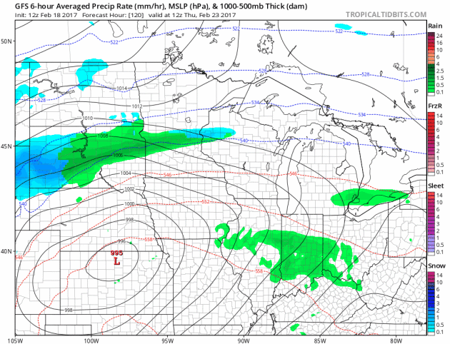
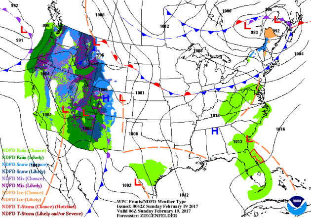
Weather Outlook for Through Early Next Week
Here's the weather outlook from Saturday to AM Tuesday. Note that we stay dry through the weekend, but a storm system arrives late Sunday into Monday with widely scattered showers and even a few rumbles of thunder! Interestingly, the 30 year average for the Twin Cities suggests that February averages less than 1 day of thunderstorms (0.1 days) during the month.

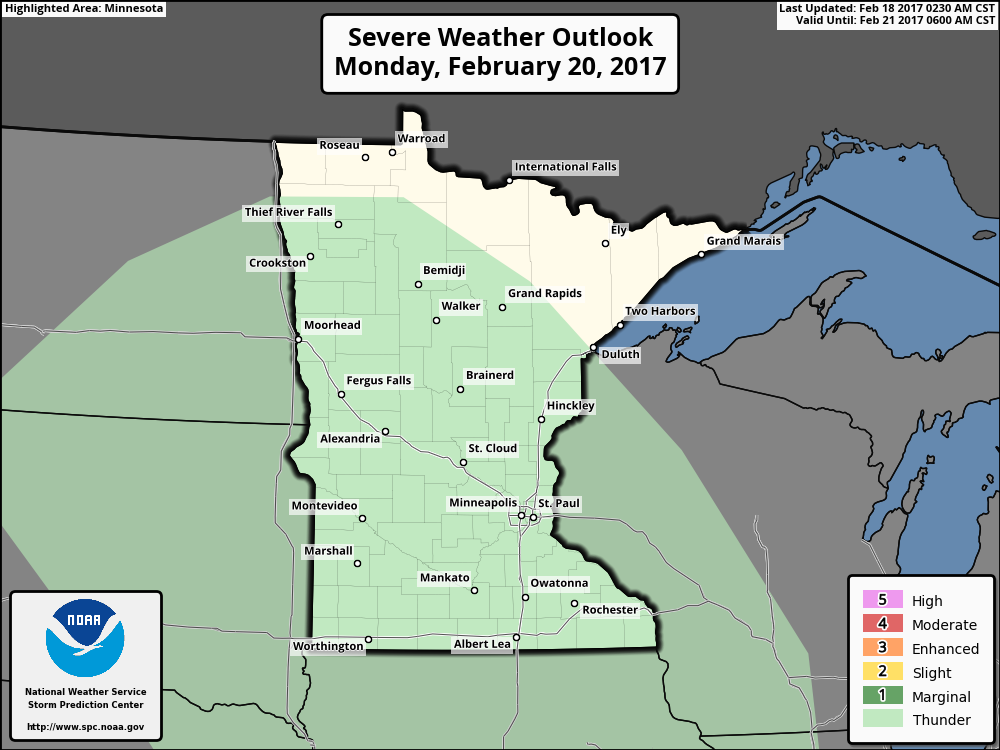
Thunder Threat Monday
Here's the thunderstorm outlook from NOAA's SPC, which suggests that general thunderstorms may be possible on Monday as the next storm system rolls through the Upper Midwest.
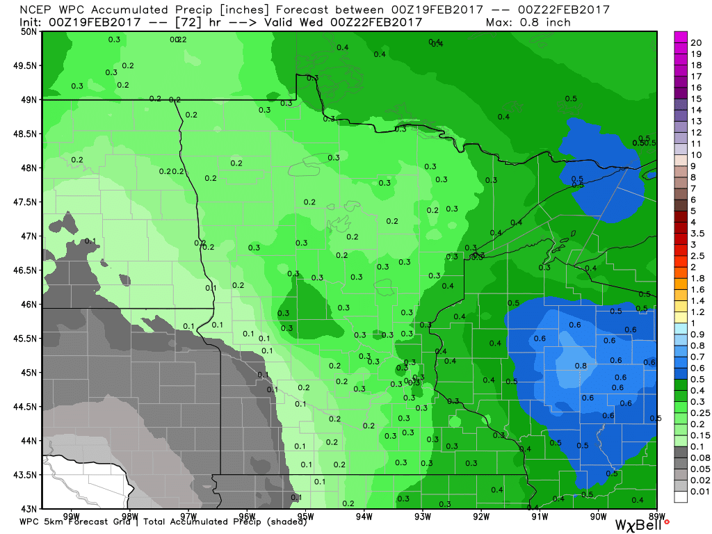
Precipitation Potential Thru Tuesday
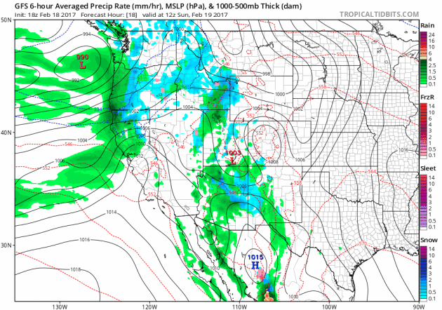
Our next storm system moving through the Upper Midwest early next week will have the potential of dropping 0.25" to 0.50" liquid across the region, some of this could be aided by thunderstorm activity on Monday. Note that the heaviest precipitation looks to fall along and east of the Mississippi River Valley into Wisconsin.
Late Week Wintry Mix and Snow Chance?
Talk about weather whiplash, take a look at the storm system that long range weather models are trying to develop by late next week. It is still WAY too early to talk about what exactly is going to happen here, but it's interesting that we could go from several days of record warmth in February to snowfall in just a few short days. Stay tuned.
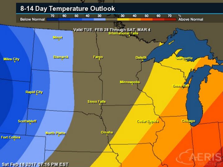
8 to 14 Day Temperature Outlook
According to NOAA's CPC, the 8 to 14 day temperature outlook suggests warmer than average temperatures continuing across much of the Upper Midwest from February 28th - March 4th. After several days of MUCH warmer than average temperatures, readings look to finally cool down by the end of the month.
_________________________________________________________________________________
Temperature Outlook
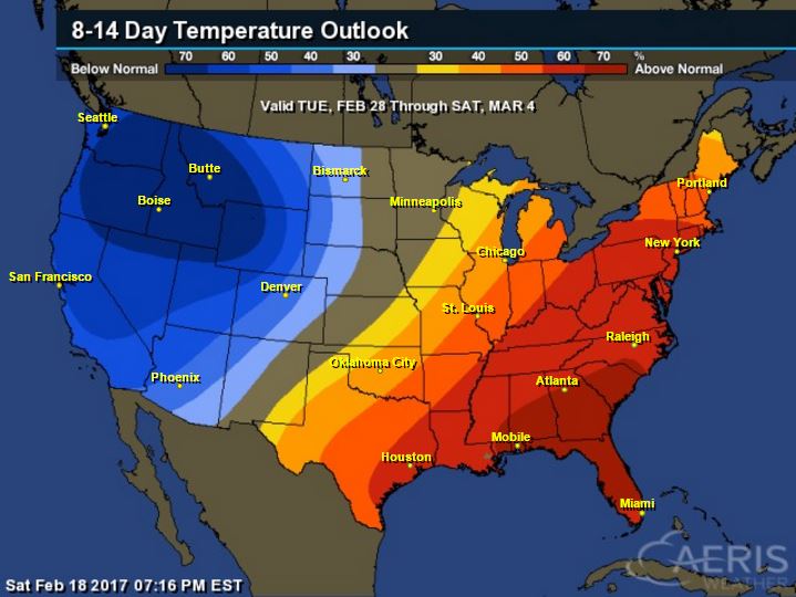
National Temp Outlook
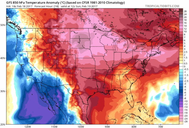
Take a look at the temperature anomaly through Saturday, February 25th. Note that the eastern half of the country looks to stay warmer than average through early next week, but colder than average temps begin moving into the western part of the country next week.Eventually this colder weather will move into the central part of the country by the last weekend of the month.
 ________________________________________________________________________________
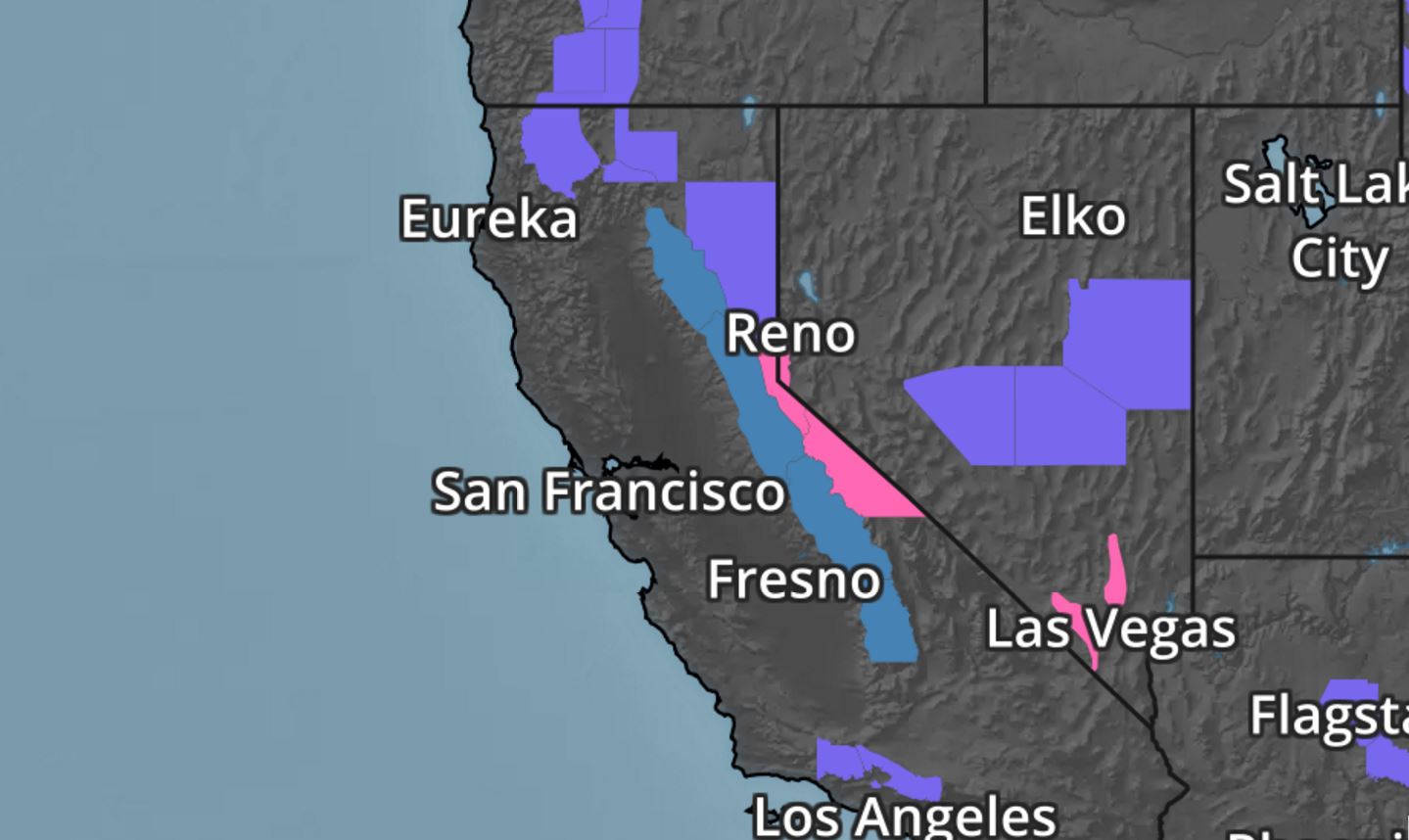
National Weather Outlook
Here's the national weather outlook through early next week, which continues to shows heavy precipitation continuing in the Western US, while a wave of energy moves into the Central US with widely scattered showers and storms.
_____________________________________________________________________
Waves of Pacific Moisture in the Western U.S. Continue
Several rounds of heavy precipitation have blasted the West Coast and we're not quite done yet. Another surge of heavy precipitation will push through the region late weekend through early next week with more flooding rains and heavy mountain snow.
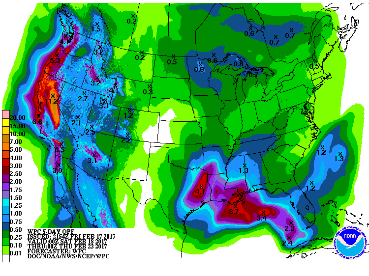
 5 Day Precipitation Forecast
Flooding Rains in California
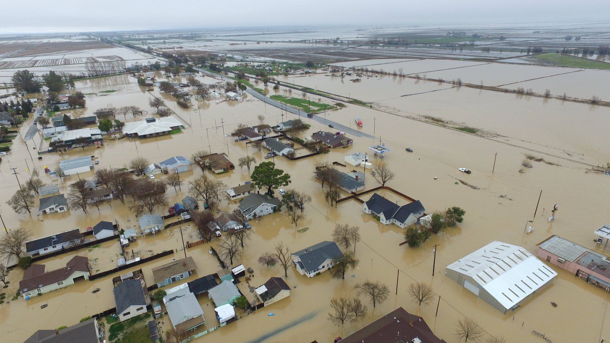
Take a look at the picture below that the National Weather Service out of Sacramento, CA posted on their Facebook page. Widespread heavy rainfall pushed through the region late last week and created quite a mess. Here are some of the heavy rainfall reports that came in from Friday.
...RECORD DAILY MAXIMUM RAINFALL ACROSS SOUTHWESTERN CALIFORNIA YESTERDAY...
A RECORD RAINFALL OF 2.77 INCHES WAS SET AT LONG BEACH AIRPORT CA YESTERDAY. THIS BREAKS THE OLD RECORD OF 1.81 INCHES SET IN 1980.
A RECORD RAINFALL OF 4.16 INCHES WAS SET AT SANTA BARBARA AIRPORT CA YESTERDAY. THIS BREAKS THE OLD RECORD OF 2.08 INCHES SET IN 1980.
A RECORD RAINFALL OF 3.86 INCHES WAS SET AT SANDBERG CA YESTERDAY. THIS BREAKS THE OLD RECORD OF 0.81 INCH SET IN 1941.
A RECORD RAINFALL OF 1.98 INCHES WAS SET AT SANTA MARIA AIRPORT CA YESTERDAY. THIS BREAKS THE OLD RECORD OF 0.88 INCH SET IN 1918.
A RECORD RAINFALL OF 1.43 INCHES WAS SET AT LANCASTER YESTERDAY. THIS BREAKS THE OLD RECORD OF 0.23 INCH SET IN 2005.
(Incredible photo this morning of major flooding this morning in Maxwell, Colusa County, CA. Photo credit Hector Iniguez.)
Flood Concerns Continue
Another round of very heavy rainfall is on its way to parts of central and northern California. Some spots could see another 2" to 4"+ rain through early next week! With the ground already saturated and some still dealing with flooding from recent heavy rains, it wont' take much addional rainfall to create more flood concerns in the area.
Winter Weather Concerns Continue
Winter Weather Concerns continue across parts of the Western US and note that the Sierra Nevada Range is expecting another round of snow from Sunday to Tuesday. Some spots could see an additional 6" to 12"+ by the time this latest round of heavy moisture fades.
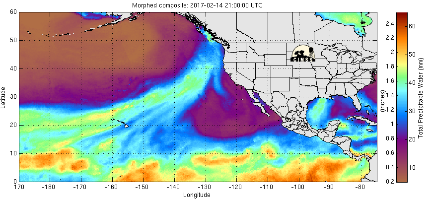
Why So Much Moisture?
Heavy precipitation has been falling across the Western U.S. due to rivers of Pacific moisture plowing into the region. Note the deep plumes of Pacific moisture that seems to be directed right toward the West Coast, these are the Atmospheric Rivers that are responsible for the extensive precipitation. Note the next big plume setting up just west of the region, this will be responsible for another heavy surge through the week ahead.
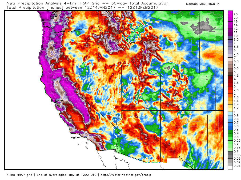
According to NOAA's WPC, the 5 day precipitation forecast suggests widespread 6" to 9"+ precipitation amounts across the West Coast through the early weekend. This will likely help improve the drought even more as we head into the 3rd week of February.
_____________________________________________________________________________
_____________________________________________________________________________
Radar Estimated Precipitation Past 30 Days
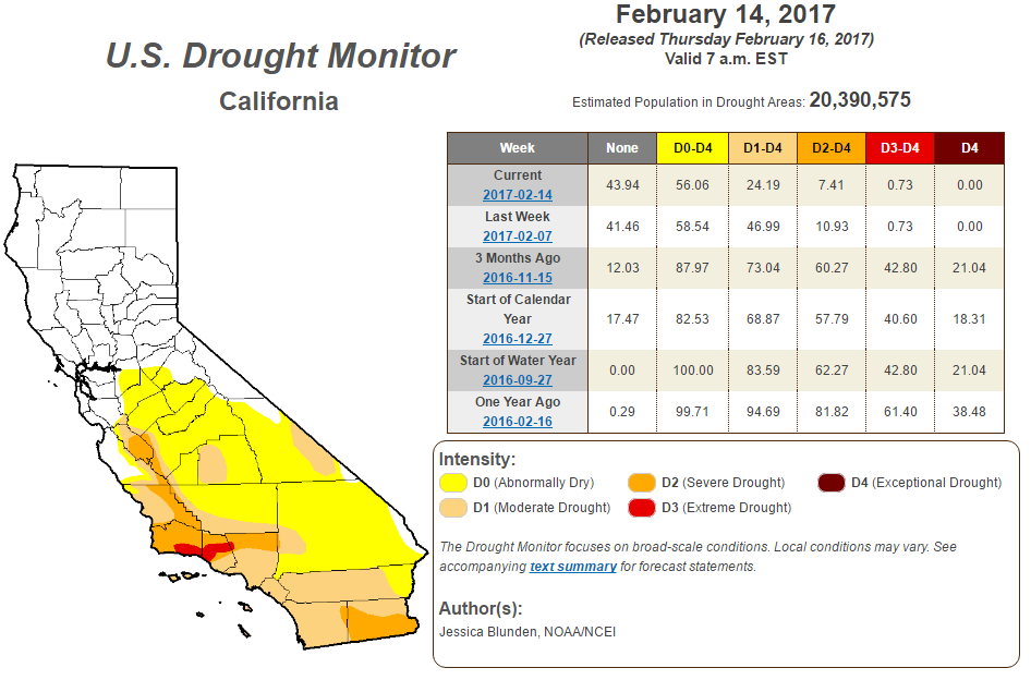
Improving California Drought
According to the U.S. Drought Monitor, the California drought continues to improve. Note that over the last 3 months, we have seen major improvement in the Exceptional, Extreme and Severe drought. With the additional moisture expected this week, we should continue to see even more improvement!
_________________________________________________________________
Snowfall Potential
Here's the snowfall potential through the end of next week, which shows heavy mountain snow continuing across parts of the Western U.S.. Also note the snow potential across the Midwest late next week... while it is still WAY to early to tell what's happening with that particular snow chance, it's worth watching. Stay tuned!
______________________________________________________________________________
_____________________________________________________________________
______________________________________________________________________________
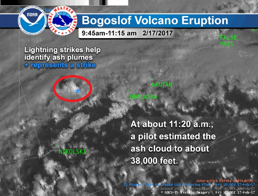
Bofoslof Volcano Erupts in Alaska Saturday Morning...
Bogoslof volcano erupted this morning with an ash cloud estimated by pilots to about 38,000 feet. The ash cloud was identified quickly with satellite and lightning data by meteorologists at the Alaska Aviation Weather Unit, Center Weather Service Unit and Volcanic Ash Advisory Center along with volcanologists at the Alaska Volcano Observatory. Early detection of eruptions occurring in remote locations like Bogoslof volcano gives advance warning to aviators to steer clear of destructive ash clouds. Follow our partner Alaska Volcano Observatory for more on Bogoslof's ongoing period of unrest in the Aleutians.
See more from the National Weather Service Alaska HERE:
See more from the National Weather Service Alaska HERE:
_____________________________________________________________________
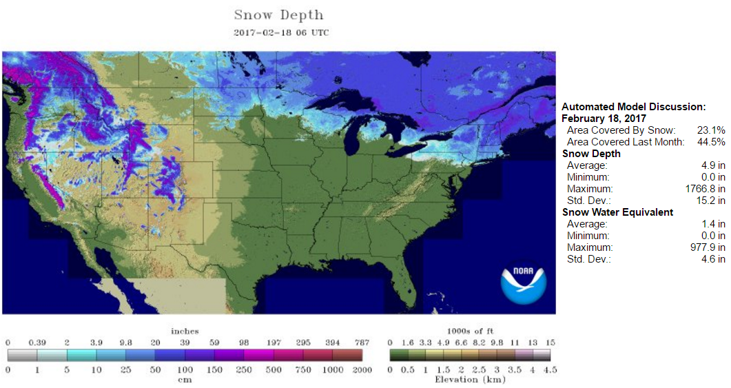
National Snow Coverage
According to NOAA's NOHRSC, 23.1% of the nation was covered by snow on February 18th. Note at this time last year, 32.3% of the nation was covered by snow and 44.7% of the nation was covered by snow 2 years ago.
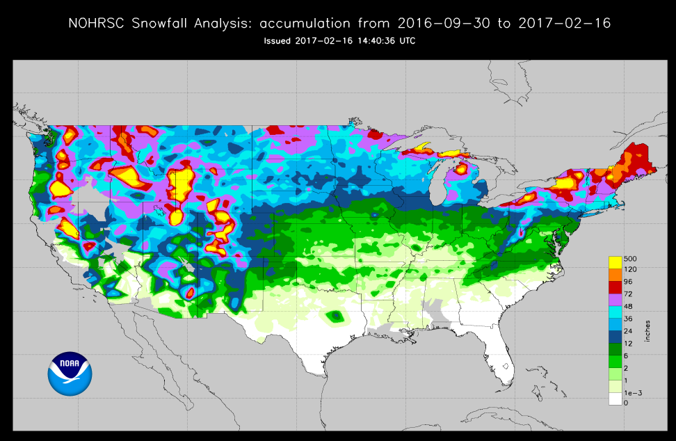
Latest Seasonal Snowfall Tallies Across the Country
According to NOAA's NOHRSC, here are the latest seasonal snowfall tallies (in map form) across the Lower 48. Note that there are heavy pockets across in Intermountain West and across the Great Lakes Region, but the heaviest is across the Northern New England States. Some spots there have seen nearly 96" of snow or more since September 30, 2016.
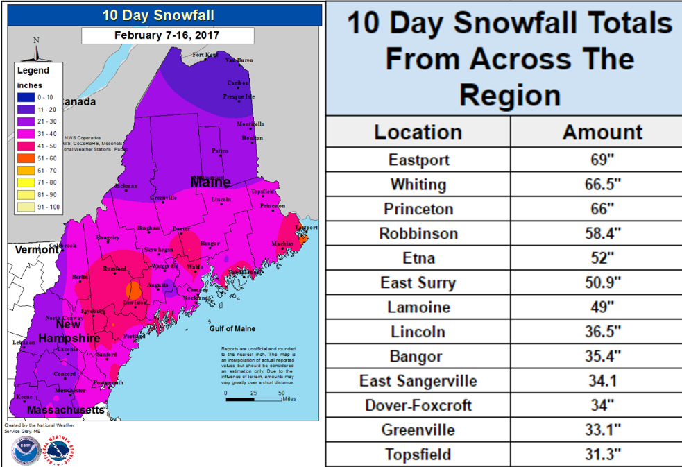
Heavy Snow in the Northeast
Take a look at these 10 days snowfall tallies from across parts of the Northern New England States. 3 different storms over the last 10 days have left some locations buried under nearly 5ft. of snow or more! Here are some of the latest snowfall tallies from the National Weather Service out of Caribou, ME.
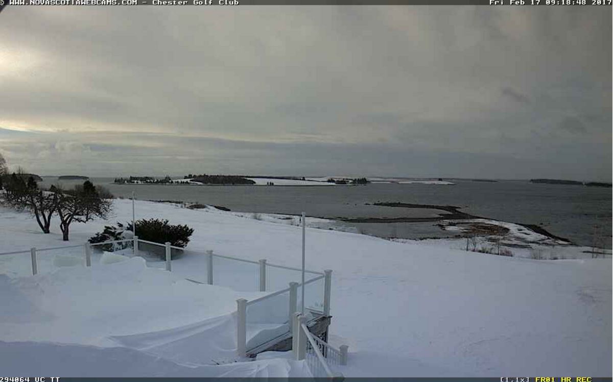
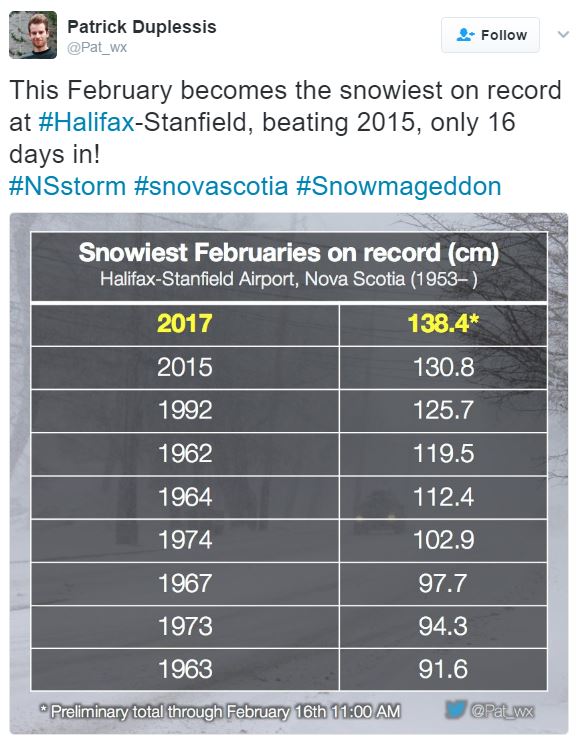
Snowiest February in Halifax, Nova Scotia, Canada
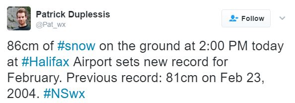
While storm after storm has been dumping heavy snow across parts of the Northeast, some of the same storms have also been bringing heavy snow to parts of eastern Canada. Take a look at the webcam below from the Chester Golf Club in Nova Scotia, Canada, note the heavy drifts on the deck! Interestingly, the Halifax Airport in Nova Scotia has just set a record for the most snow during the month of February with 138.4cm (~54.4"). The Halifax Airport also set a new snow depth record, which was 86cm (~33.9"), beating the old record of 81cm (~31.9") set on Feb 23, 2004.
_________________________________________________________________________________
Feels More Like Spring Than February
Thanks to my cousin Jessica Gust for the picture below who is spending time in Atlanta, GA where spring has apparently already sprung! She snapped these pictures from the Atlanta Botanical Garden... it looks beautiful Jess, thanks!
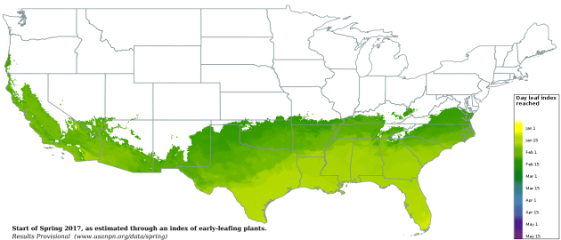
 According to USA National Phenology Network, areas in the green color below show where spring has already sprung across parts of the Southern U.S.. Their definition of spring is this: The appearance of the first tiny leaves on the trees, or the first crocus plants peeping through the snow? "The Spring Leaf Index is a synthetic measure of these early season events in plants, based on recent temperature conditions. This model allows us to track the progression of spring onset across the country."
"The map below shows locations that have reached the requirements for the Spring Leaf Index model (based on NOAA National Centers for Environmental Prediction Real-Time Mesoscale Analysis temperature products)."
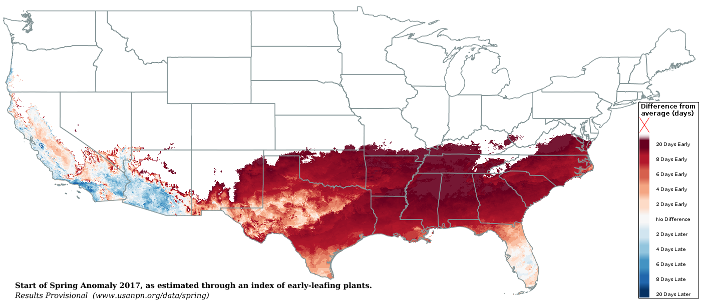
 Start of Spring Anomaly 2017
Interestingly, spring has sprung 20+ days ahead of normal in some locations across the Southern U.S..
Start of Spring Anomaly 2017
Interestingly, spring has sprung 20+ days ahead of normal in some locations across the Southern U.S..
"We can evaluate whether spring is arriving early, late, or right on time this year at a location by comparing the day of year the Spring Leaf Index requirements were reached in 2017 to the day of year the Index is typically reached. We determine what is typical for a location by averaging the day the Index was reached over the 1981-2010 period. The number of days a between when the Index was reached this year and when it is typically reached at a location is called the “anomaly.”"
Thanks to my cousin Jessica Gust for the picture below who is spending time in Atlanta, GA where spring has apparently already sprung! She snapped these pictures from the Atlanta Botanical Garden... it looks beautiful Jess, thanks!
Start of Spring... Already?
"The map below shows locations that have reached the requirements for the Spring Leaf Index model (based on NOAA National Centers for Environmental Prediction Real-Time Mesoscale Analysis temperature products)."
"We can evaluate whether spring is arriving early, late, or right on time this year at a location by comparing the day of year the Spring Leaf Index requirements were reached in 2017 to the day of year the Index is typically reached. We determine what is typical for a location by averaging the day the Index was reached over the 1981-2010 period. The number of days a between when the Index was reached this year and when it is typically reached at a location is called the “anomaly.”"
___________________________________________________________________
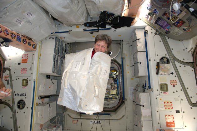
"A NASA Astronaut Just Pulled Off an Awesome Prank in Space"
NASA astronaut Peggy Whitson just pulled off a prank that's literally out of this world. Whitson, a veteran space traveler, is one of six people living and working on the International Space Station right now. And while astronauts are usually pretty busy in space, Whitson found time Monday (Feb. 13) to surprise her Russian crewmates with a gag you could only pull off in space. As you can see here, Whitson packed herself inside a cargo bag and enlisted two partners-in-prank (NASA's Shane Kimbrough and France's Thomas Pesquet) to surprise their Russian crewmates. [Fun in Zero G: Awesome Weightless Photos] "They were quite surprised when I popped out!" Whitson wrote in a Twitter post.
(NASA astronaut Peggy Whitson pops out of a cargo bag during a prank on the International Space Station on Feb. 13, 2017. Credit: Peggy Whitson/Twitter/NASA)
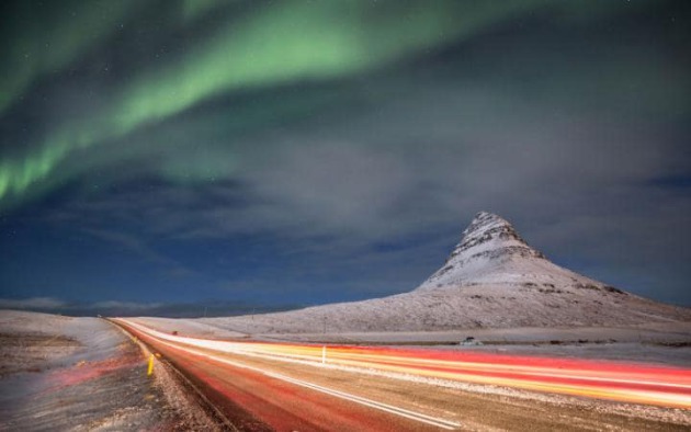
"The Northern Lights is distracting drivers, Icelandic police warn"
"We are all familiar with the risks of driving under the influence of alcohol, but what about driving under the influence of the Aurora Borealis? Well, that’s becoming an increasing problem in Iceland, according to local police, who say foreign motorists are driving dangerously because they are being distracted by the Northern Lights. According to the local news site, Víkurfréttir, police stopped two motorists for driving dangerously last week; in both incidents the officers suspected the drivers were drunk, but soon realised they had a more innocent explanation for their behaviour: they had been distracted by the light show above them."
(Motorists have reportedly been "driving under the influence of the Aurora Borealis"CREDIT: AP/FOTOLIA)
________________________________________________________________________________
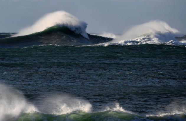
"Scientists have just detected a major change to the Earth’s oceans linked to a warming climate"
"A large research synthesis, published in one of the world’s most influential scientific journals, has detected a decline in the amount of dissolved oxygen in oceans around the world — a long-predicted result of climate change that could have severe consequences for marine organisms if it continues. The paper, published Wednesday in the journal Nature by oceanographer Sunke Schmidtko and two colleagues from the GEOMAR Helmholtz Centre for Ocean Research in Kiel, Germany, found a decline of more than 2 percent in ocean oxygen content worldwide between 1960 and 2010. The loss, however, showed up in some ocean basins more than others. The largest overall volume of oxygen was lost in the largest ocean — the Pacific — but as a percentage, the decline was sharpest in the Arctic Ocean, a region facing Earth’s most stark climate change."
(Big waves generated by the Nazare canyon just off the coast of Nazare, central Portugal, in the Eastern Atlantic Ocean. (Francisco Leong/Agence France-Presse via Getty Images))
Thanks for checking in and don't forget to follow me on Twitter @TNelsonWX

No comments:
Post a Comment