55 F. tied record high on Wednesday in St. Cloud. Record high was 55 F. set in 1961.
29 F. average high for the STC metro area on February 22.
33 F. high temperature on February 22, 2016.
February 23, 1981: Warmth returns to Minnesota with a high of 55 at Pipestone and a high of 52 at Luverne.
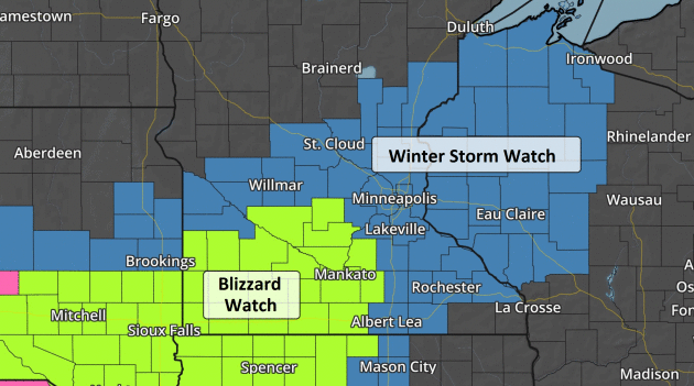
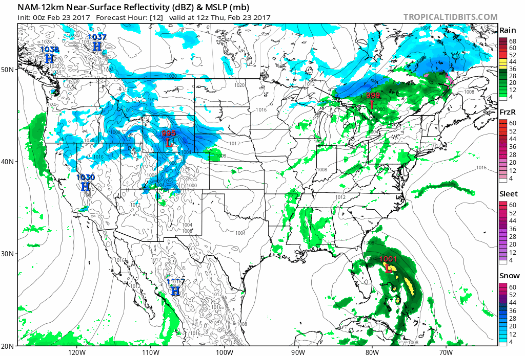 Biggest Snowstorm of the Winter Possible Friday
"The
weather never repeats, but sometimes it rhymes." After 60s, golf,
convertibles and gawking at Minnesotans in shorts, in February, are you
really shocked the other shoe (boot) is about to drop? Me neither.
Every
storm is different, uniquely baffling. An area of low pressure may be
similar to a previous storm, but never identical. That's humbling and
challenging, since weather models only go so far.
The days leading
up to a big weather event feel like your first drivers exam. You try to
be confident but there's just so much that can go wrong. Models still
disagree on who will see the most snow, but plowable amounts seem
likely. It may be a blizzard just south and west of MSP tonight and
early Friday. Winds gusting over 40 mph at MSP on Friday may whip up
white-out conditions here as well.
The metro area could still be
in the axis of heaviest snow; as much as 6-12 inches of sloppy wet snow (especially southern suburbs) -
capable of spin-outs, even power outages tomorrow. If you have a comp
day coming I'd take it tomorrow. Avoid the travel mess altogether.
No more 60s, just 30s and 40s into mid-March. You know, 'average'?
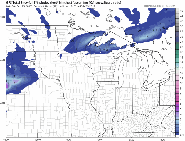
Southward Shift In Track?
The 00z run of NOAA's GFS model shows plowable amounts of snow brushing
the MSP metro, but extreme (1 foot plus) snowfall amounts limited to
southeastern Minnesota, closer to Rochester and Winona. This is more in
line with the ECMWF (European) solution. The best chance of 6-12" may
come south of the Twin Cities late tonight into Friday. Loop:
Tropicaltidbits.com.
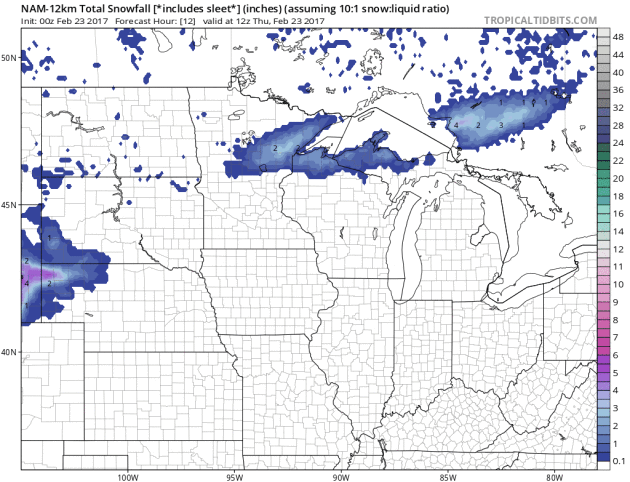
NAM Still More Impressive.
The axis of heaviest snow is closer to the Twin Cities on last night's
00z run, with over a foot for the southern suburbs. But the TREND is
shifting the storm track farther south, pushing the heaviest amounts
south of MSP. I had a sneaky suspicion that a foot of snow might be
wishful thinking. It's still not out of the question, but we have to
follow the trends.
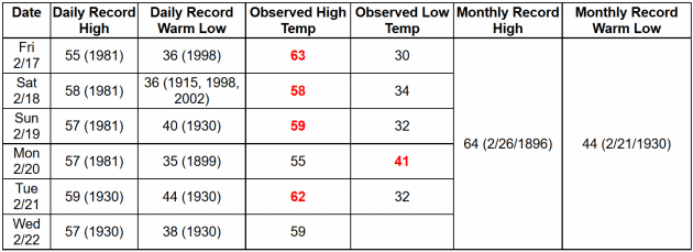
5 Warm Weather Records in 6 Days. According to NOAA 4 record highs and 1 record warm nighttime low since Friday. Impressive.
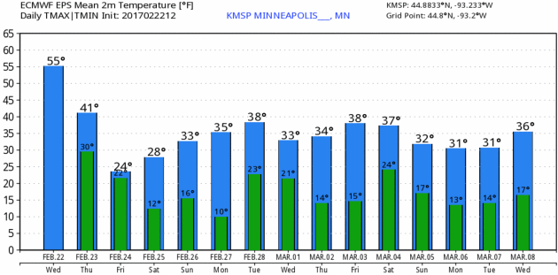
Colder - But Not Arctic.
Keep in mind the average high is 31 degrees. Even with cooler weather
imminent temperatures will still trend a few degrees above average for
late February and early March. Keep a heavy jacket handy. ECMWF numbers:
WeatherBell.
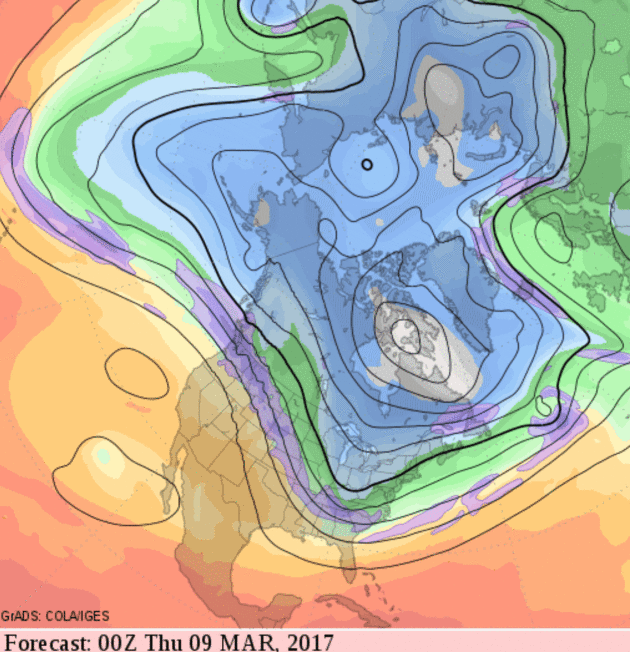
Cold Weather Swipes for Northern USA.
The atmosphere may undergo a slight correction next month as colder air
drains south across Canada, swept into the USA in waves behind a parade
of storms. The pattern doesn't look frigid, but seasonably chilly from
the Northern Plains and Midwest into the Great Lakes and New England
with a push of chilly air into the southeastern USA the second week of
March.
 AerisWeather Briefing
:
Issued Wednesday, February 22
nd, 2017
*
After days of record highs across the Plains and upper Midwest, a
system tracking in from the Rockies will bring heavy snow with it for
the second half of the week.
* Snow will start off in Wyoming and Nebraska, spreading east throughout the day
Thursday, then linger in the upper Midwest
on Friday. This will bring the potential of 6-12”+ of snow with it from Nebraska to Wisconsin.
* Due to the heavy snow threat, Winter Storm Watches have been issued from Wyoming to Wisconsin for the second half of the week.
*
We will also be watching the potential for strong winds, which will
cause blizzard/white-out conditions throughout the storm as well,
especially in the upper Midwest.
Snow Moves Into The Upper Midwest. As we head into
Thursday
morning, snow will already be in progress across portions of Wyoming,
Nebraska and South Dakota. The snow will spread east as the system moves
east throughout the day
Thursday, reaching the Twin Cities by
Thursday
evening. Snow, heavy at times, will continue through the overnight
hours and into the day Friday across the upper Midwest, with snow
continuing to fall across the Twin Cities through
Friday afternoon. In some of the heaviest snow, snowfall rates of 1-2” per hour will be common, leading to hefty accumulations.
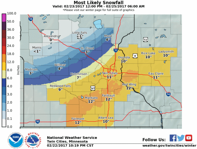
Potential Snow Totals. As
the system moves east over the next couple days, the heavy snow
associated with it will move into the upper Midwest. We will be watching
the potential for over a foot of snow across portions of Nebraska,
South Dakota, Minnesota and Wisconsin. This would cause major travel
issues, potentially even impassable roads, toward the end of the week.
Note that the exact path of the storm could still shift north or south a
little bit over the next several days as we get closer to the event,
but heavy snow over the region is likely. Map: Aeris AMP.
Local Weather Service Additional Snow Forecasts:
Cheyenne, WY Area:
 Rapid City, SD Area:
 North Platte, NE Area:
 Sioux Falls, SD Area:
 Twin Cities, MN Area:

 Blizzard Potential.
 There
will also be strong winds associated with this heavy snow threat across
the upper Midwest as we go into the end of the week. We could see wind
gusts over 35 mph at times, creating blizzard/white-out conditions. This
is a look at the track of our Blizzard Potential Index over the past
four runs of the model. While there has been movement in the where
blizzard conditions are possible, the signal is there for white-out
conditions from Wyoming to the upper Midwest during the storm. This
would be able to cause significant travel issues.
Summary:
Heavy snow will be possible across the northern Plains and upper
Midwest during the second half of the week as a storm system emerges
from the Rockies and moves east. This snow will be impactful to the
region, with the potential of 6-12”+ of snow from Nebraska to Wisconsin,
including the Twin Cities of Minnesota. In some areas totals will
likely top a foot, as snowfall rates at times will be on the order of
1-2” per hour. This will make travel difficult across parts of the
region. Add on top of that strong winds that will cause
blizzard/white-out conditions and travel could become nearly impossible,
especially
on Friday in parts of South Dakota, Minnesota and Wisconsin.
D.J. Kayser, Meteorologist, AerisWeather
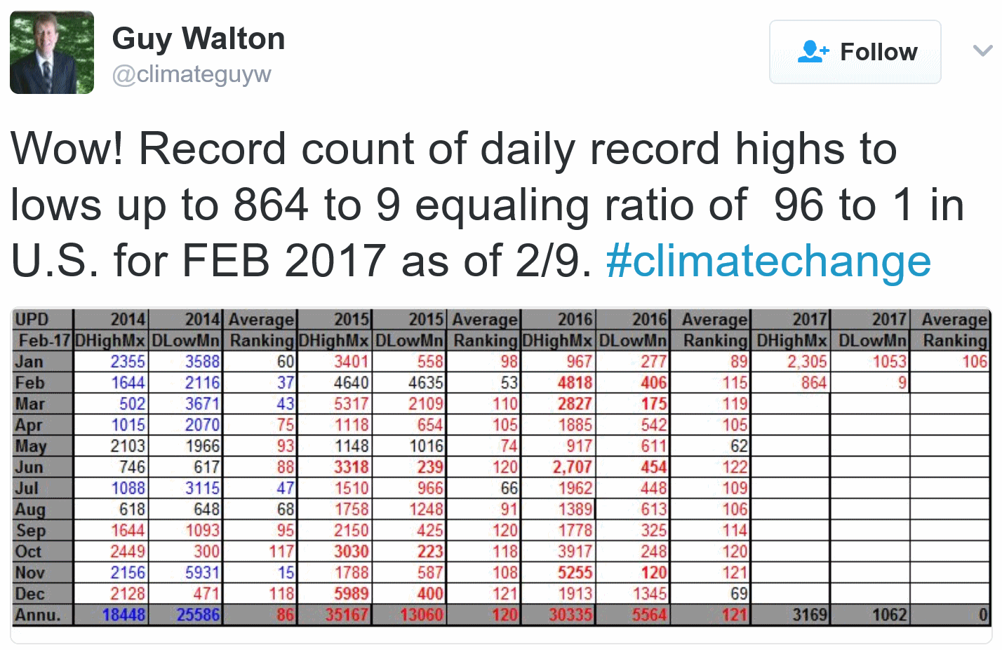
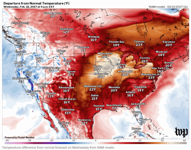
Middle America is Basking in Unprecedented February Warmth. Jason Samenow at
Capital Weather Gang has some of the jaw-dropping details: "
The
weather this February keeps getting weirder. At a time when Arctic
blasts usually sweep across the nation and Northern states are covered
in snow and ice, historically warm air has flooded the eastern
two-thirds of the nation. All-time February record high temperatures are
falling and the air feels more like early May. A stunning 2,805 record
high temperatures have occurred across the nation this month compared
with just 27 record lows. The warmest air with respect to normal has
focused on the Midwest and, in some areas, it’s unlike anything they’ve
ever witnessed. Flower stems are sprouting in Chicago, and the Great
Lakes are practically ice-free. In an area normally thick with ice, “a
boat was seen skimming over the calm waters of Lake Michigan on Monday
afternoon,” CBS Chicago reported...."

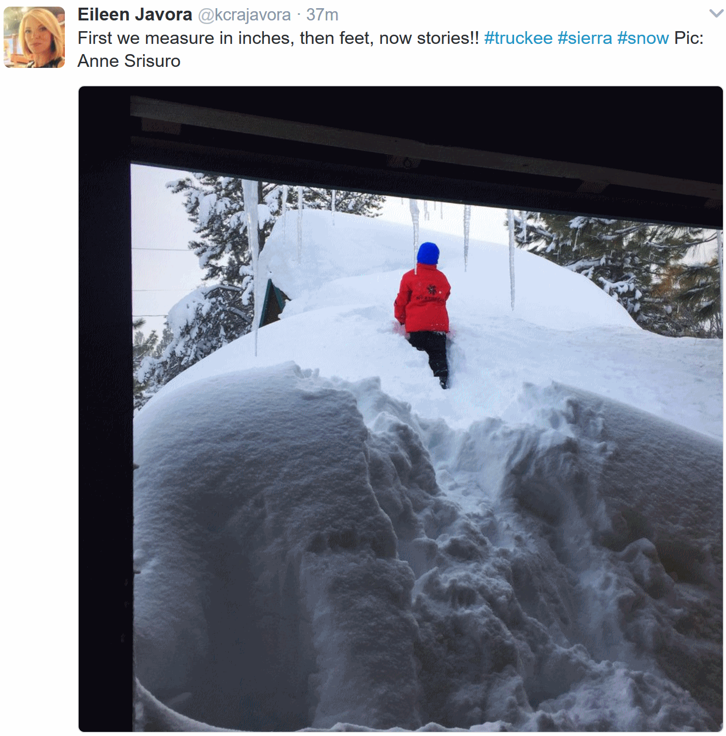
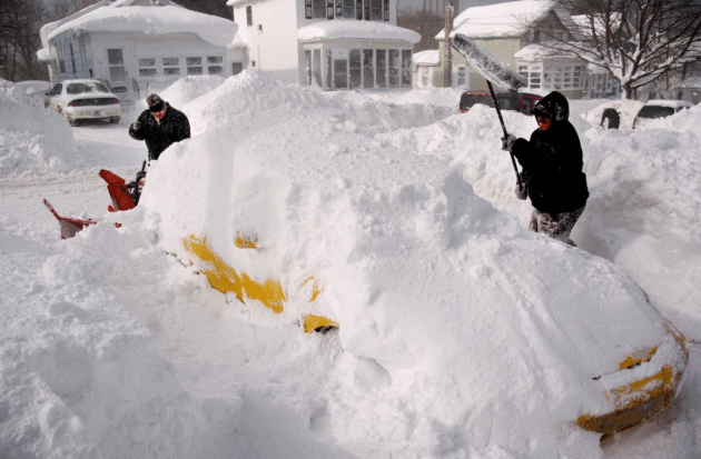
Snowiest Place in New York has 25 Feet and Counting. MSN.com documents the snowy wonderland of Oswego County, New York - ground zero for lake effect snow squalls: "
For most in upstate New York, a foot of snow is an intimidation.
For Carol Yerdon, it’s a milestone. By Sunday morning, more than 24
feet of snow already had fallen this winter in the corner of Oswego
County where Yerdon lives. Then it began to snow again. A foot or more
was in the forecast. By noon Sunday, enough fresh snow was on the ground
for Yerdon to hit her mark. “Yes we did it! We hit 300 inches,” Yerdon
said. “Just 125 inches to go to break the record!...”
Photo credit:
Kevin Rivoli/AP Photo. "Steve
Meier, right, and John Bellavia dig out Bellavia's car in Osewgo, N.Y.,
Friday, Feb. 9, 2007. New York's Governor Eliot Spitzer declared a
disaster in Oswego County, where five straight days of lake-effect
squalls have dumped nearly 100 inches (254cm) of snow, with even more
snow forecast through the weekend."
Flooding Forces Hundreds from Homes in San Jose, California.
Reuters has an update: "
Murky,
waist-high floodwaters swamped neighborhoods along a rain-swollen creek
in the northern California city of San Jose on Tuesday, prompting
authorities to issue evacuation orders or advisories for more than 1,000
homes, city officials said.
The state's third-largest city, a hub of the high-tech Silicon Valley
corridor south of San Francisco, has about 1 million residents and
declared an emergency as Coyote Creek overflowed its banks from days of
heavy showers. The trash-strewn
floodwaters inundated whole city blocks, submerging parked cars and
lapping at the walls of apartments and townhouses, as firefighters in
inflatable boats ferried stranded residents to dry ground..."
"1-in-100 Year Flood Event" for Northern California. The Los Angeles Times has more details.
14,000 in San Jose Flee High Water. KQED News has the story.
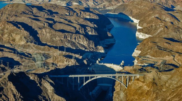
Wet Winter Has Improved Colorado River Basin's Water Forecast, But The Drought Endures. Here's an update from
The Los Angeles Times: "...
Yet
there is one place where the precipitation has been particularly
welcome and could be transformative: the Colorado River basin, which
provides water to nearly 40 million people across seven states. “We’re
in a really good spot as far as snow accumulations,” said Malcolm
Wilson, who leads the Bureau of Reclamation’s water resources group in
the upper Colorado River basin. In fact, if the Rocky Mountains continue
to see substantial snowfall this winter, there is a chance that later
this year, water managers for the Colorado could do something that
seemed inconceivable just a few weeks ago: They could start giving water
away..."
Photo credit: "
Lake Mead reservoir and the Hoover Dam show a "bath tub ring" from low water levels in 2015." (Irfan Khan / Los Angeles Times)
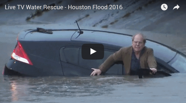
Fine, Water Doesn't Scare You? How About $10,000? The Weather Social
calls attention to the people who believe their vehicle can somehow
magically transform into a boat and get them safely to the other side of
a flooded road. Here's an excerpt: "...
In
all seriousness, you need to get to work and you need to earn your pay.
But if it’s really about collecting a paycheck, realize that driving
across a flooded road could set you back way more than a day or week of
pay. According to cartalk.com,
once water reaches the doors and the engine stalls, your wallet is
going to open up like a floodgate. Expect damage to carpets, floor mats,
door panels and the trunk liner. Seats and any motion mechanics or
sensors will need to be replaced. Water will get into the gas tank as
well and thus need drained. The brakes will need to be replaced.
Finally, the biggest issues will come from engine damage. Water in the
cylinders and transmission will need to be drained.
Especially when nobody is hurt, we regularly dismiss pictures of
stalled vehicles and say, “not me.” Especially when we’ve driven it
before, we regularly look at a flooded street and say, “I can make it...”
Earth's "Technosphere" Now Weighs 30 Trillion Tons, Research Finds. That's the estimated weight of all the (crap) we've created, according to a new study highlighted at
The University of Leicester: "...
An
international team led by University of Leicester geologists has made
the first estimate of the sheer size of the physical structure of the
planet’s technosphere – suggesting that its mass approximates to an
enormous 30 trillion tons. The technosphere is comprised of all of the
structures that humans have constructed to keep them alive on the planet
– from houses, factories and farms to computer systems, smartphones and
CDs, to the waste in landfills and spoil heaps. In a new paper
published in the journal The Anthropocene Review, Professors Jan
Zalasiewicz, Mark Williams and Colin Waters from the University of
Leicester Department of Geology led an international team suggesting
that the bulk of the planet’s technosphere is staggering in scale, with
some 30 trillion tons representing a mass of more than 50 kilos for
every square metre of the Earth’s surface..."
 Why We Need the EPA
. Rivers are no longer catching on fire - that's probably a good thing, right? Here's an excerpt from
NRDC: "..
.A
collective memory lapse seems to have descended on lawmakers who seek
to dismantle an agency that has transformed American life for the
better. Since the EPA’s founding in 1970, concentrations of common air
pollutants, like sulfur dioxide, have dropped as much as 67 percent. The EPA helped mitigate catastrophes like acid rain, leaded gasoline, and DDT. The agency bravely classified secondhand smoke as a known carcinogen in 1993, paving the way for successful litigation against the tobacco industry and an incredible reduction in U.S. smoking rates...."
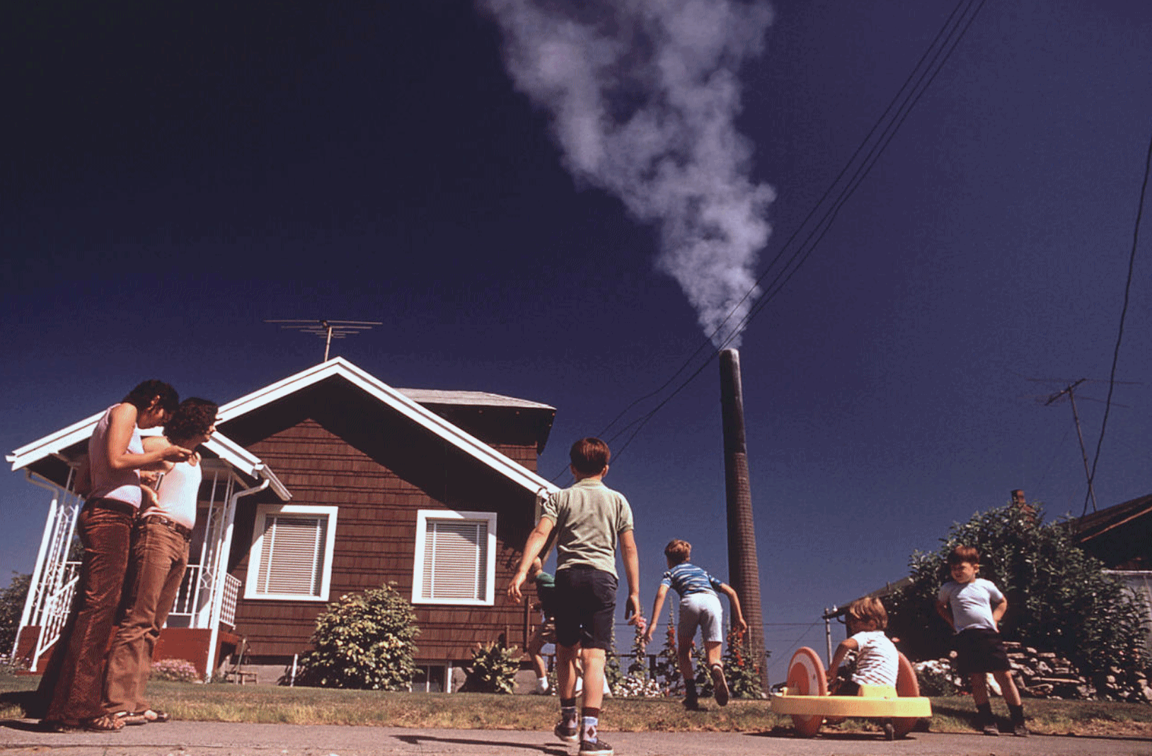
Photo credit: "Children
playing in the yard of a Ruston, Washington, home while a Tacoma
smelter stack showers the area with arsenic and lead residue, August
1972." Gene Daniels/U.S. National Archives.
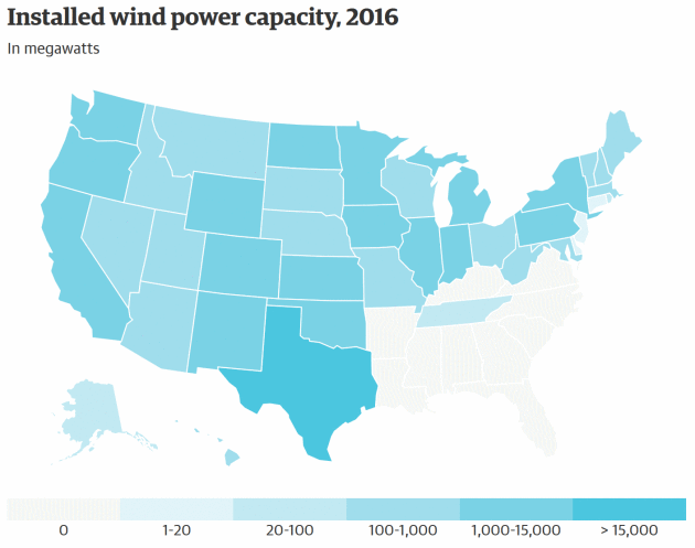
"The Wild West of Wind" - Republicans Push Texas as Unlikely Green Energy Leader. The Guardian explains the benefits of wind power in Texas: "...For
ranchers facing ruin until major international companies planted
forests of 300ft-tall turbines among their crops and cattle, the wind
boom has provided regular income that has allowed them to maintain their
land and keep it in the family. For Texas, this most
Republican-dominated, oil-rich and fracking-friendly of states has found
itself with the improbable status of being a national leader in this
growing form of renewable energy. Texas has 11,592 turbines and an
installed wind capacity of 20,321 megawatts, according to the American
Wind Energy Association: three times as much capacity as the next state,
Iowa. (California is third.)..."
Map credit:
US Department of Energy | Graphic: Jan Diehm/The Guardian.
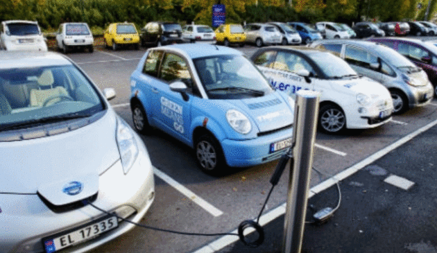
37% of Norway's New Cars are Electric. They Expect It To Be 100% in Just 8 Years. Here's an excerpt from
ThinkProgress: "
The
global electric vehicle (EV) revolution reached another milestone last
month as EVs made up 37 percent share of Norway’s car market. Norway
understands the future of ground transport is electric and has been
pushing EVs harder than almost any other country in the world with
incentives such as an exemption from the 25 percent VAT tax
for new cars. In December, the country hit 100,000 zero-emission EVs on
the road, and they are projected to quadruple to 400,000 by 2020. These
numbers are especially remarkable for a country of only 5.2 million
people. Over five percent of all of Norway’s cars are EVs, up from one
percent two years ago..." (File image: The Local Norway).
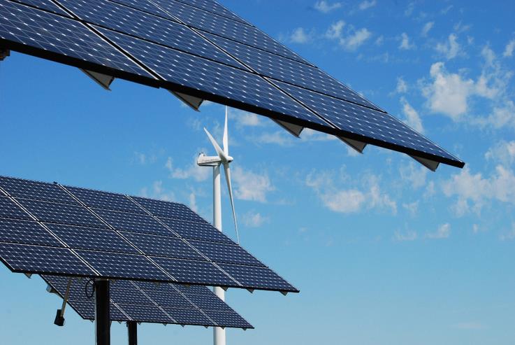
Personal View: Clean Energy Revolution Offers Jobs, Opportunity. Crain's Cleveland Business has the Op-Ed; here's a clip: "...
In
a letter applauding the decision, companies like Nestle and Whirlpool
stated that renewable energy and energy efficiency standards help them
save money, stay competitive and avoid energy price volatility. With
renewed market certainty and predictable policy, Ohio is encouraging
businesses to continue investing in clean energy locally. Across the
country, the clean energy sector provides well-paying employment for
millions of Americans. In the Midwest alone, clean energy jobs are
expected to grow at a rate of 4.4% this year, almost nine times as fast
as the long-term national average..."
Photo credit: MN.gov.
Los Angeles: The World's Most Traffic-Clogged City? So says a new report highlighted at
ABC News: "
Low
fuel prices and economic stability are straining the country's
roadways, leading to congestion that cost U.S. drivers nearly $300
billion in wasted gas and time last year, according to a new report
released today. Los Angeles had the worst traffic in the world among
1,064 cities studied by traffic analytics firm INRIX. L.A. also topped
the Kirkland, Washington, firm’s list the year before. On average, Los
Angeles motorists spent about 104 hours stuck in traffic during the peak
commuting hours of 2016, contributing to a loss of $2,408 per driver,
or about $9.7 billion collectively, in wasted fuel and productivity,
according to the firm’s Global Traffic Scorecard report..." (Image credit: INRIX Global)
The Mall of America is Looking for a Writer-In-Residence. Sign me up. Here's an explainer at
Atlas Obscura: "
The Mall of America, which Wikipedia describes as “a shopping mall located in Bloomington, Minnesota” and which is also the largest mall in the United States, is looking for a writer-in-residence. During a tough era for the traditional shopping mall,
the Mall of America, opened in 1992, has persevered and is turning 25.
As part of the celebration, the mall is looking for “a special scribe”
to celebrate the mall and capture its evolution. The job: Spend five days “deeply immersed in the Mall atmosphere” and write “on-the-fly impressions” of the place..."
Egg Vending Machine? Atlas Obscura has details: "
Sure,
you could go and buy your eggs at the grocery store like everyone else.
Or, you could go and get yourself 18 cage-free eggs from the vending
machine at Glaum’s Egg Ranch in Aptos, California, a farm that features
dancing animatronic chickens. Yep, dancing chickens. Stick four crisp
dollar bills in the slot and out comes a tray of 18 fresh eggs while a
chorus of animatronic chickens in seasonal attire sing and dance for you.
The costumes change, but no matter the holiday, their song remains the
same: a clucking version of Glenn Miller’s “In the Mood.”Stick four
crisp dollar bills in the slot and out comes a tray of 18 fresh eggs
while a chorus of animatronic chickens in seasonal attire sing and dance for you.
The costumes change, but no matter the holiday, their song remains the
same: a clucking version of Glenn Miller’s “In the Mood...”
TODAY: Cooler as clouds thicken. Winds: NE 10-15. High: near 40
THURSDAY NIGHT:
Winter Storm Watch. Mix changes over to heavy wet snow. Low: 30
FRIDAY:
Winter Storm Watch. Windy with snow. 2-4" possible, much more southern MN. Winds: NE 20-40. High: 32
SATURDAY: Travel improves. Slow clearing late. Winds: NW 10-20. Wake-up: 17. High: 30
SUNDAY: Mostly cloudy, flurries north. Winds: S 5-10. Wake-up: 20. High: 32
MONDAY: Mix of clouds and sun, quiet. Winds: S 8-13. Wake-up: 21. High: 36
TUESDAY: Icy mix, slick roads possible early. Winds: SE 10-15. Wake-up: 25. High: 39
WEDNESDAY: Wet snow tapers to flurries. Winds: NW 10-20. Wake-up: 27. High: 35
Climate Stories....
 What Your TV Meteorologist Likely Thinks of Climate Change.
 Dr. Marshall Shepherd has a post at
Forbes: "...
One
of the issues that always comes up is the assumption that all
meteorologists are on TV. The Boston Globe article went on to talk
primarily about broadcast meteorologists, which represent less than 10%
of meteorologists yet the title said "many meteorologists." It is very
common for the public to assume meteorologists are just on TV. I get the
question, "what channel are you on?" all of the time. The AMS in
conjunction with George Mason University recently surveyed its
membership, which is far broader than just the small sample of broadcast
meteorologists. According to a summary of the report on the AMS
website,
The vast majority of members of
the American Meteorological Society agree that recent climate change
stems at least in part from human causes, and the agreement has been
growing significantly in the last five years. According to a new survey
of AMS members, 67% say climate change over the last 50 years is mostly
to entirely caused by human activity, and more than 4 in 5 (80%)
respondents attributed at least some of the climate change to human
activity..."
 Do You Know Someone Who Should Be Recognized for Climate Adaptation Efforts?
The Minnesota Climate Adaptation Partnership (MCAP) will be recognizing
outstanding climate adaptation work in Minnesota with awards to be
presented on May 8, 2017, as part of the National Adaptation Forum.
MCAP is joining the National Adaptation Forum in offering a conference
that will present a range of practitioners who have experience with
climate smart strategies for adapting to our changing climate. The
conference titled
Action today for a better tomorrow, will be
held at the St. Paul River Centre, May 8-11, 2017. Awards will honor
individuals, organizations, institutions and businesses that have
provided exceptional leadership in education, research, policies, and
practices to improve resilience and develop, advance, or implement
climate adaptation strategies. Anyone may submit a nomination, which is
very simple. The award nomination deadline is March 1, 2017, and
nomination details are available on the University of Minnesota Water
Resources Center web site:
https://www.wrc.umn.edu/news-events/climateadaptationconference
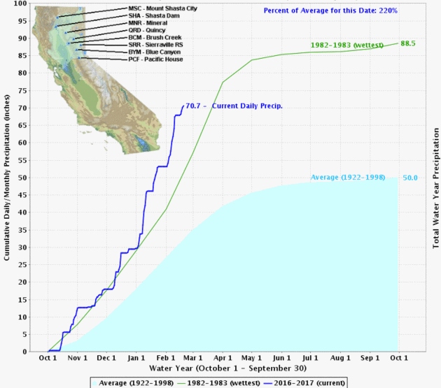
Expect to See More Emergencies Like Oroville Dam in a Hotter World. Rain is falling harder. That's not a climate model prediction, but an observational reality. Here's an excerpt from
The Guardian: "...
Like
many extreme events, the Oroville emergency is a combination of natural
weather likely intensified by climate change. California regularly sees
“atmospheric rivers” that deluge the state with rainfall, but in a
hotter world, scientists anticipate that they’ll be amplified by an increase in the amount of water vapor in the atmosphere. Northern California is in the midst of its wettest rainy season on record – twice as wet as the 20th
century average, and 35% wetter than the previous record year. It
proved to be almost too much for America’s tallest dam to handle..."
Graphic credit: "
Northern California Sierra precipitation - average, previous wettest year, and 2016-2017." Illustration: California Department of Water Resources.
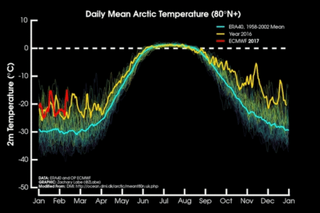
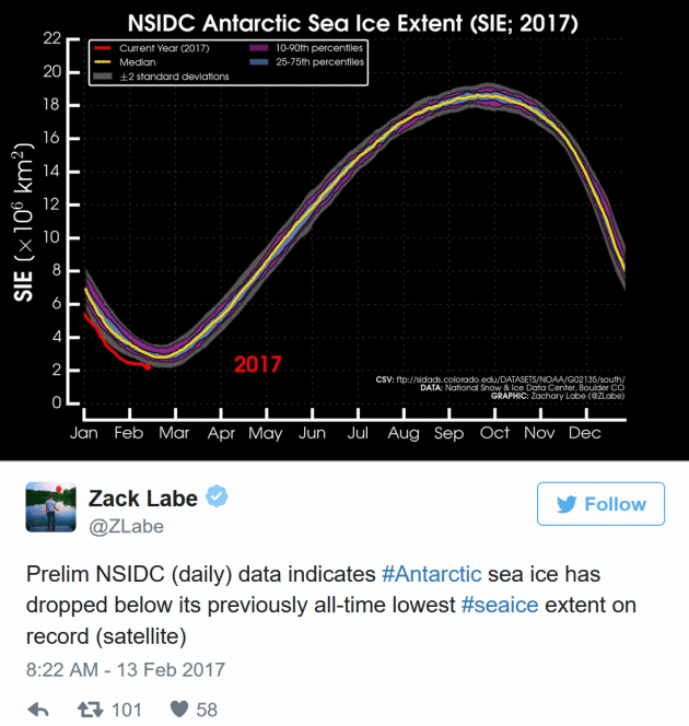
Sea Ice Hits Record Lows at Both Poles. Details via
Climate Central: "
Arctic temperatures have finally started to cool off after yet another winter heat wave
stunted sea ice growth over the weekend. The repeated bouts of warm
weather this season have stunned even seasoned polar researchers, and
could push the Arctic to a record low winter peak
for the third year in a row. Meanwhile, Antarctic sea ice set an
all-time record low on Monday in a dramatic reversal from the record
highs of recent years...."
Graphic credit: "
Air
temperature 2 meters above the surface for the Arctic north of 80
degrees latitude for 2017 (red), compared to 2016 (yellow), and the
long-term average (blue)." Credit: Zack Labe/ Danish Meteorological Institute
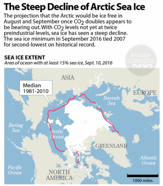
Researcher's 1979 Arctic Model Predicted Current Sea Ice Demise, Holds Lessons for Future. Here's a clip from
InsideClimate News: "
Claire Parkinson, now a senior climate change
scientist at NASA, first began studying global warming's impact on
Arctic sea ice in 1978, when she was a promising new researcher at the
National Center for Atmospheric Research. Back then, what she and a
colleague found was not only groundbreaking, it pretty accurately
predicted what is happening now in the Arctic, as sea ice levels break record low after record low. Parkinson's study,
which was published in 1979, found that a doubling of atmospheric
carbon dioxide from preindustrial levels would cause the Arctic to
become ice-free in late summer months, probably by the middle of the
21st century. It hasn't been ice-free in more than 100,000 years.
Although carbon dioxide levels have not yet doubled, the ice is rapidly
disappearing. This record melt confirms the outlook from Parkinson's
1979 model..."
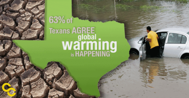
Even in Texas, People Worry About Climate Change.
Yale Climate Connections reports: "
The
majority of Americans understand that climate change is real. Contrary
to stereotypes, that’s true in both liberal and conservative states. For
example, 68 percent of people in Vermont say global warming is
happening. And 63 percent of Texans agree. Dobbs: “When you talk to the
people of Texas and you ask them about these things, time and time again
they show an interest in protecting our climate, in protecting our
planet, in protecting our resources. And this goes across the political
spectrum, across the social spectrum, across the geographic spectrum in
our state.” That’s Andrew Dobbs, a program director at the Texas
Campaign for the Environment. He says recent severe droughts and floods
have led to increased concern..."
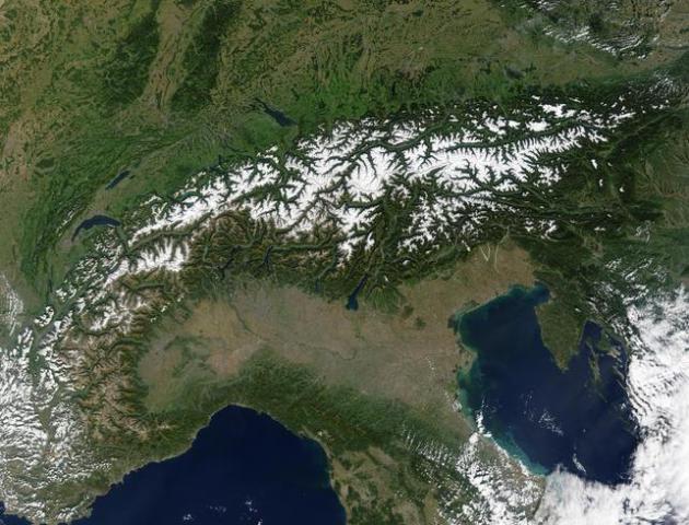
The Alps Could Lose 70 Percent of Their Snow Cover by 2100.
Travel + Leisure has the details: "
The Alps
could lose up to 70 percent of their snow cover in the next century,
according to new research conducted by Swiss scientists. As the popular skiing range has
seen record low snowfalls over the past years, the trend is set to
continue and worsen, according to a study published in the European
Geosciences Union (EGU) journal The Cryosphere. In a best case scenario, if the Paris climate agreements are
followed, limiting the warming of the earth by 2 degrees Celsius (3.6
degrees Fahrenheit), the Alps will lose at least 30 percent of their
snow cover by 2100. If greenhouse gas emissions are not properly
contained, that number could jump to 70 percent..." (File image: NASA).
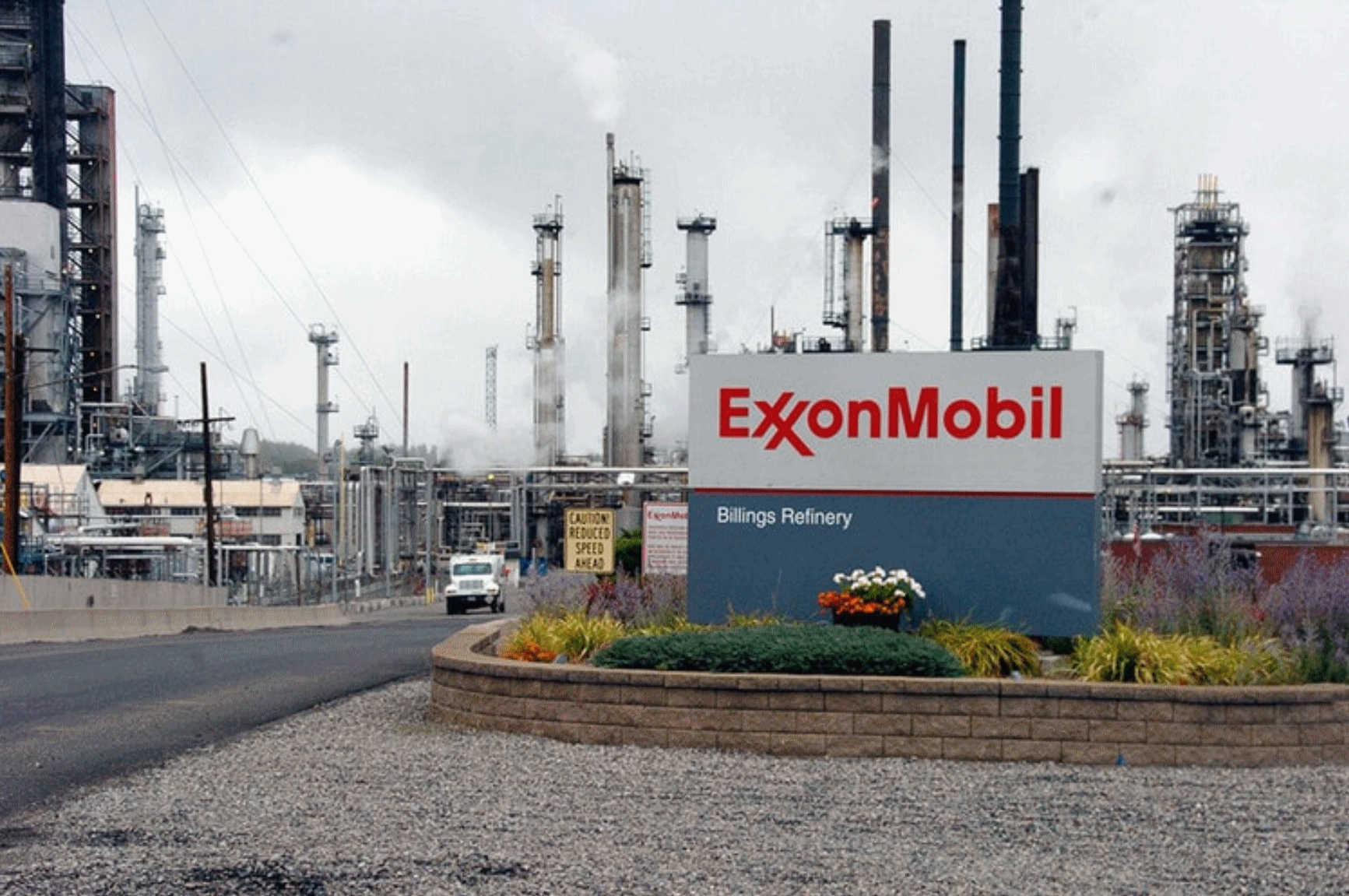
Companies Are Concealing the Risks of Climate Change. So says a post at
Inverse; here's an excerpt: "...
Whatever
policy direction the SEC takes on climate risk, it is unlikely to deter
those investors who believe the present system of voluntary and
mandatory disclosure has failed to provide them with sufficient
information on the risks of climate change. And some market
participants, such as Bank of England Governor Mark Carney,
worry that the underreporting of climate change information is creating
a big risk for financial markets – a carbon bubble – that could lead to
a major market failure. Currently, the SEC requires mandatory
disclosure of all “material” information, while everything else is voluntary. This system has created a vast amount of publicly available information on the costs and risks of climate change..."
Photo credit: "ExxonMobil’s refinery in Billings, Montana."
 The Problems with Winter Warming.
 I'm
enjoying the extended streak of spring fever in February (!) as much as
everyone else, but at the risk of being Debby Downer there are some
downsides to spring coming extra-early. Here's a post from
Climate Central: "
The
decrease in winter cold effectively makes the winter shorter. While
that might sound good at first, it comes with consequences for
recreation, farming, and the environment. In colder climates,
winter-based recreational activities, like skiing, ice fishing, and
snowmobiling will become less prevalent. More disease-carrying insects,
like mosquitoes and ticks, will survive through a milder winter.
Declining snow pack leads to lower reservoir levels, providing less
water for irrigation of crops. Fruit trees, which need to become dormant
in the winter to blossom in the spring, may produce smaller yields.
Pollen counts will rise, which can trigger respiratory illnesses for
allergy sufferers."
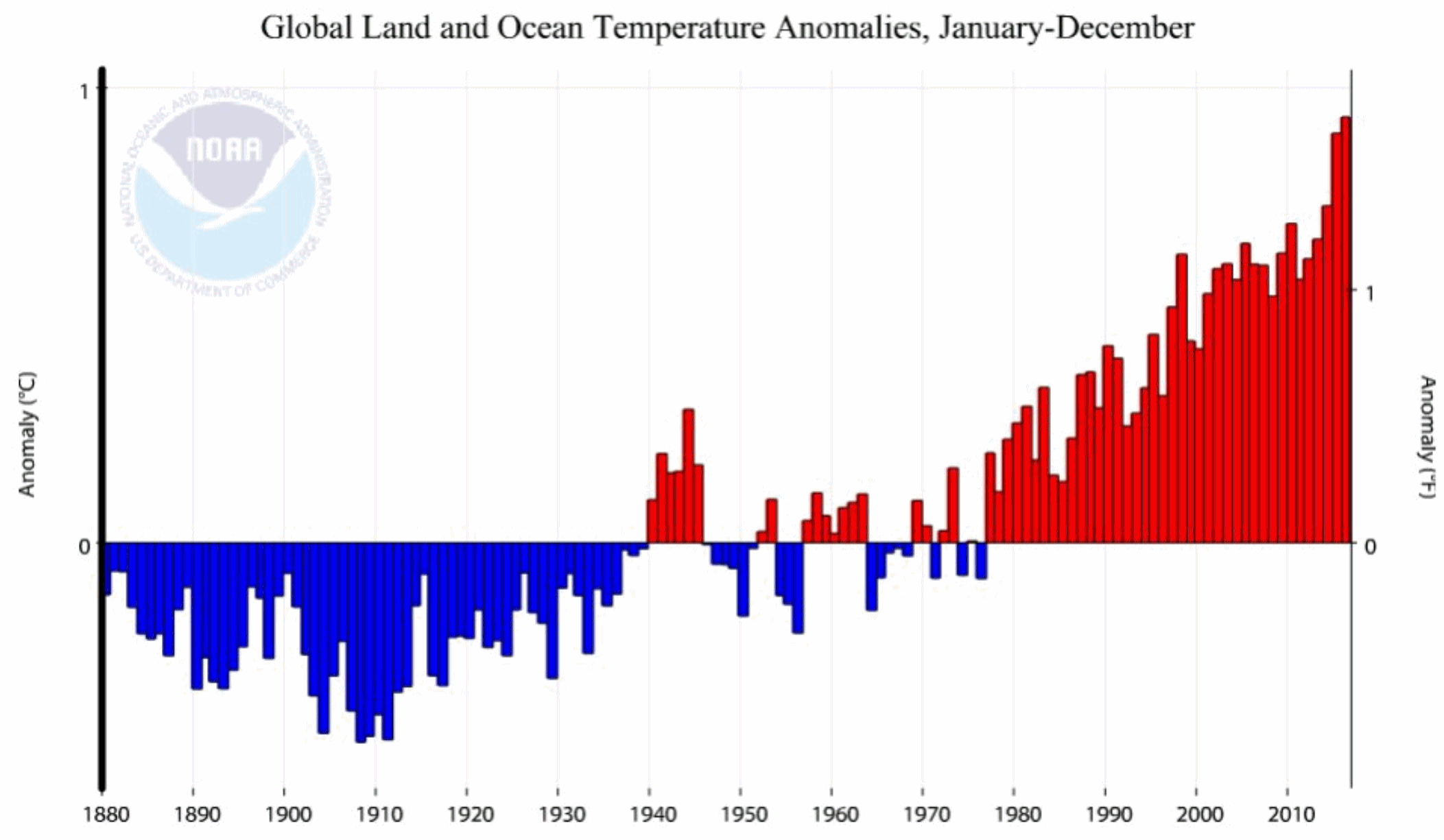
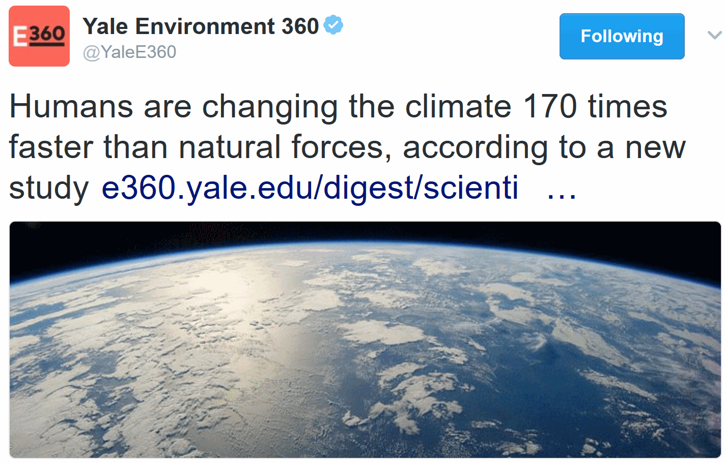 Humans Changing Climate 170 Times Faster than Natural Forces. Yale Environment360
 has a summary of new research: "
Humans are changing the climate 170 times faster than natural forces, according to a new study
published in the peer-reviewed journal The Anthropocene Review. The
research is the first mathematical equation to compare the impact of
human activity on current climate to naturally occurring changes. For 4
billion-plus years, astronomical and geophysical factors, such as solar heat output and volcanic eruptions,
were the dominating influences on Earth’s climate, argue study authors
Owen Gaffney and Will Steffan, climate scientists at Stockholm
University and Australian National University, respectively. But over
the past six decades, human activities like the burning of fossil fuels
and deforestation “have driven exceptionally rapid rates of change,” the
study says..."


No comments:
Post a Comment