Heavy Snow in the Northeast
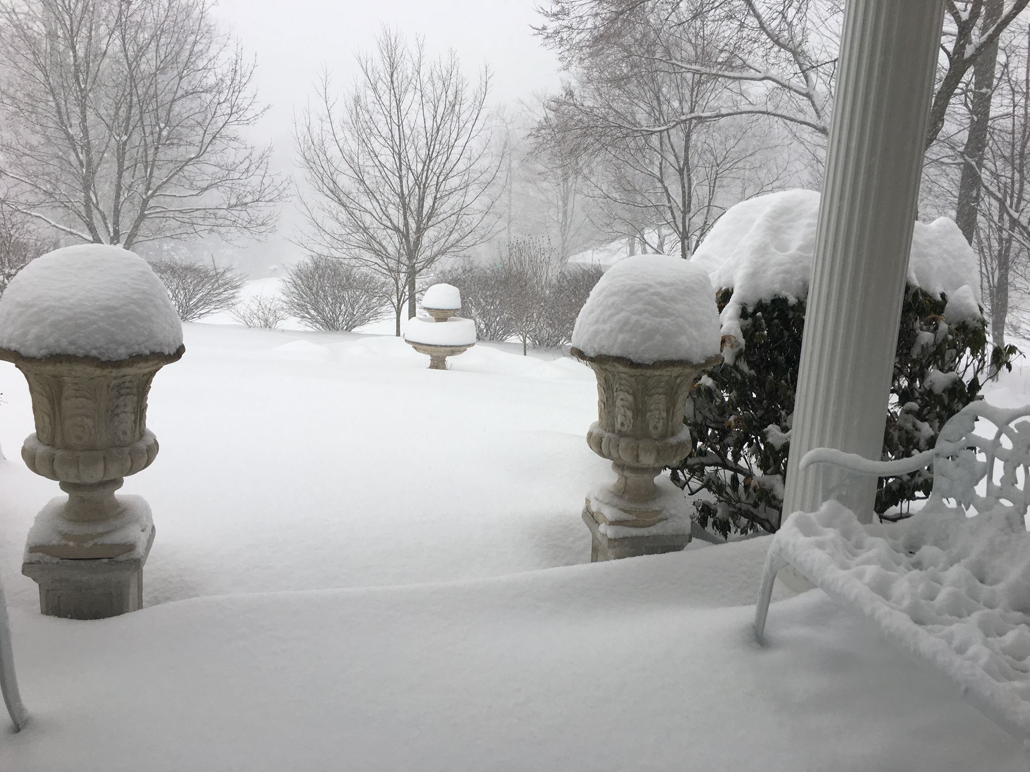
Thanks to Noreen Clark from Mountain Top, PA for the picture below who measured more than 20" of fresh snow on Tuesday! Snowfall rates with this particular storm were on the order of 2" to 4" per hour at times. It came down fast and furious with winds gusting up to 50mph or more made for a very wintry day across the Northeast. Widespread 1ft to 2ft amounts blanketed much of the region, which brought some places to a hault. Folks will spend much of the rest of the week cleaning up after this particular mid March snow event.

Heavy Snow in the Northeast
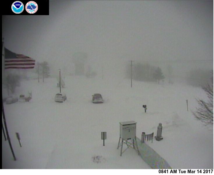
Here's a great webcam shot from the National Weather Service out of Binghamton, NY where earlier Tuesday, they reported 11.6" of snow in a 4 hour time frame! Now that's intense!
See the latest NWS Binghamton webcam HERE:
See the latest NWS Binghamton webcam HERE:
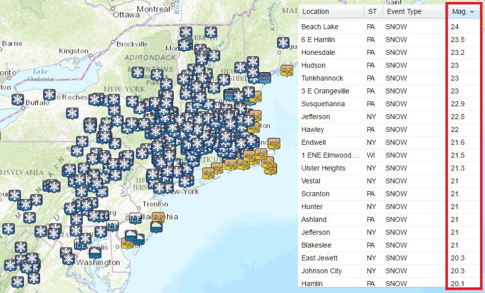
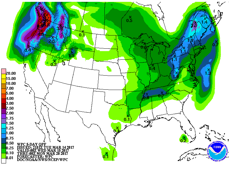
Early Snowfall Totals
As of Tuesday, some of the heaviest snowfall amounts were pushing close to 2ft across parts of Pennsylvania and New York! This was definitely a very large and hard hitting storm that impacted a very large area from the Mid-Atlantic to the Northeast.
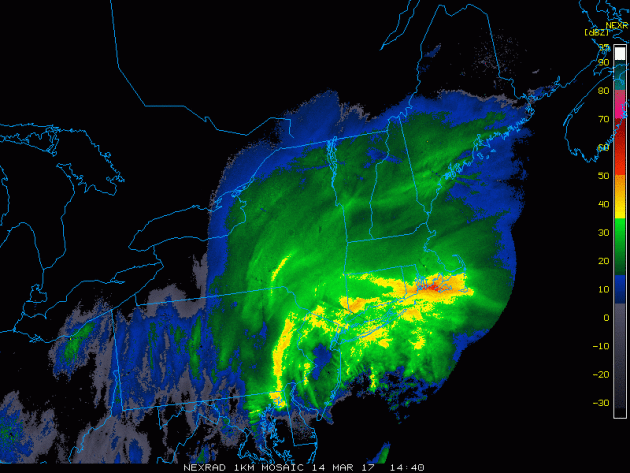
Heavy Snow in the Northeast
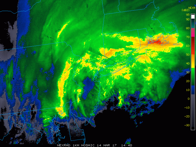
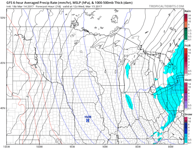
This was the radar mid/late morning on Tuesday as some of the heaviest snow transitioned from the northern Mid-Atlantic states into the Northeast. Note the bright yellows, oranges and reds, this is where snowfall rates were at their greatest, at times close to 2" to 4" per hour!
.gif)
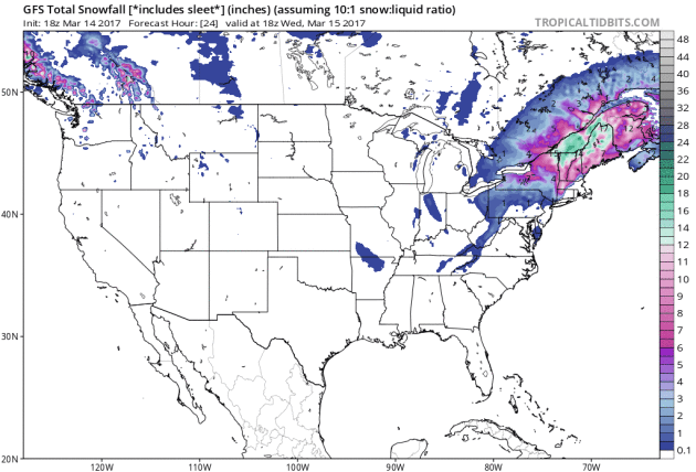
Storm System Fades Wednesday
After a very active PM Monday through AM Wednesday, the storm system that brought up to 1ft. to 2ft. of snow and near 50mph to 60mph wind gusts will begin to fade on Wednesday. Here is the forecast from AM Wednesday to PM Thursday, which shows the storm system quickly moving out with only a few lingering light snow showers across the region Thursday.
.gif)
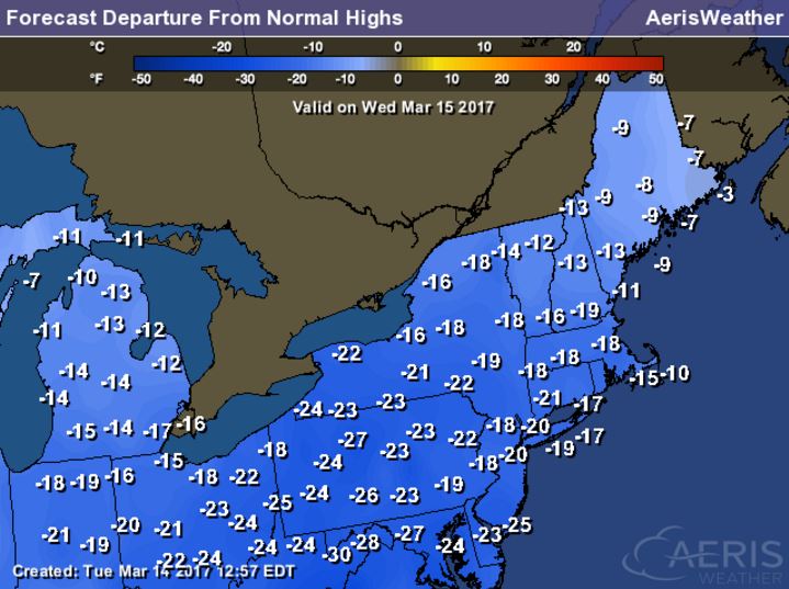
Cold Temps in the Wake of the Storm...
Temperatures in the wake of the storm system will be quite chilly, here's a look at the high temperatures from average on Wednesday. Note that some spots may be as much as 10F to 25F below average for March 15th!
_____________________________________________________________________
It was busy at grocery stores earlier this week at folks prepared for a forecast that called for up to 2ft of snow across parts of the Northeast. While the storm shifted a little farther west and New York got missed by the heaviest amounts, folks should still be well stocked in the food department at home. Take a look at how long the lines were! Here's an excerpt from Gothamist.com:
The threat of up to 20 inches of snow has sparked the usual run on NYC grocery stores, with long lines reported at Trader Joe's, supermarkets like FoodTown, and Whole Foods, where lines were 45 minutes long by 5 p.m. in Williamsburg (#WHYGOD?). Family-sized bottles of vegetable oil? DECIMATED. Bread products? SHOULD HAVE SHOPPED ON SUNDAY. Bottled water? HOPE YOUR TAP WORKS.
(Whole Foods Union Square (Scott Heins/Gothamist))

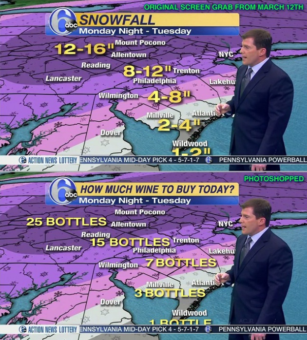
Wine Bottle Forecast?
Ok, ok... someone had a little too much fun with this one. Leave it to a viewer to come up with a photoshopped wine bottle forecast... good grief! Here's an excerpt from Adweek.com:
"A viewer expertly reconfigured snow totals predicted on-air Sunday night by Sowers into more colorful wine-bottle supply recommendations. The beauty-and-the-beast of social media is that it doesn’t matter if the screen grab aired or was even created by the person depicted. As Sowers noted in his comments to New York magazine, he was amazed at how quickly a social media buzz was fostered."
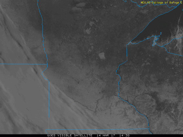
Visible Satellite on Tuesday
Here's the visible satellite loop from Tuesday, which showed mostly sunny skies across the region. Note the whiter coloring across the southern half of the state, this is from the recent heavy snow that fell Sunday into AM Monday. The Minnesota River Valley can be seen very plainly as well as the ice covered lakes of Mille Lacs, Leech and Upper/Low Red Lakes.
_____________________________________________________________________________
Beware the Ides of March. Chilly Sun Continues
By Todd Nelson, filling in for Douglas
By Todd Nelson, filling in for Douglas
The time change is goofing me up. Not sure I've officially made the transitions and I know for a fact my young kids haven't. I was questioned at bedtime earlier this week; Why are you sending me to bed when it is still light outside?
Despite the increased difficulties in tricking my kids to bed, I do enjoy the later sunsets. Note that we've gained a little more than 3 hours of daylight since the Winter Solstice on December 21st. Interestingly, we are gaining nearly 3 minutes of daylight per day as we approach the Vernal Equinox on Monday.
A major snow event wraps up Wednesday in the Northeast. Widespread 1 to 2 foot amount with wind gusts nearing 60 mph created quite a wintry mess there. Colder than average temperatures in the wake of the storm system keep us chilly through today, but 40s return by the end of the week with a shot at 50 degrees by Sunday.
March can be a fickle month, no question. Heavy snow, freezing temperatures and summer heat are all possible. Do you remember St. Patty's Day 2012 when we hit 80 degrees? Lucky...
___________________________________________________________________________
___________________________________________________________________________
Extended Forecast:
TUESDAY NIGHT: Mostly clear and cold. Winds: NNW 5. Low: 7
WEDNESDAY: Chilly, more PM clouds. Winds: SSW 5. High: 32
WEDNESDAY NIGHT: Partly cloudy and quiet. Not as cold. Winds: S 5. Low: 21
THURSDAY: Warmer. Few PM sprinkles/showers. Winds: SSE 5-10. High: 44
FRIDAY: Breezy. Lingering sprinkles/flurries. Winds: NW 15-25. Wake-up: 33. High: 44
SATURDAY: Winds subside late. Gradual clearing. Winds: NNW 10-15. Wake-up: 26. High: 45
SUNDAY: Winds pick up again. Hazy sunshine. Winds: NNW 10-15. Wake-up: 29. High: 50
MONDAY: Light wintry mix early. Winds: NW 10-20. Wake-up: 34. High: 50
TUESDAY: Partly sunny and breezy. Winds: WNW 10-20. Wake-up: 31. High: 48.
_______________________________________________________________________________
_______________________________________________________________________________
This Day in Weather History
March 15th
March 15th
1941: The 'Ides of March Blizzard' occurs. Winds reached hurricane force at Twin Cities. 32 people died.
_______________________________________________________________________________
_______________________________________________________________________________
Average High/Low for Minneapolis
March 15th
March 15th
Average High: 41F (Record: 70F set in 2015)
Average: Low: 24F (Record: -7F set in 1897)
Average: Low: 24F (Record: -7F set in 1897)
*Record Snowfall: 5.0" set in 1899
_______________________________________________________________________________
_______________________________________________________________________________
Sunrise Sunset Times For Minneapolis
March 15th
March 15th
Sunrise: 7:25am
Sunset: 7:19pm
Sunset: 7:19pm
*Daylight Gained Since Yesterday: ~3 minutes & 9 seconds
*Daylight Gained Since Winter Solstice (December 21st): ~3 hours & 08 minutes
________________________________________________________________________________
*Daylight Gained Since Winter Solstice (December 21st): ~3 hours & 08 minutes
________________________________________________________________________________
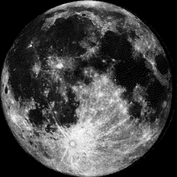
Moon Phase for March 14 at Midnight
2.7 Days After Full Worm Moon
2.7 Days After Full Worm Moon
________________________________________________________________________________
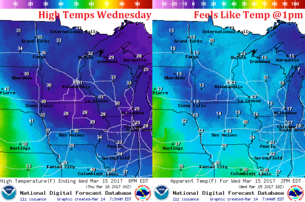
Weather Outlook For Wednesday
High temperatures on Wednesday will be quite chilly across the region with highs across the state in the 30s, which will be 5 to 10 degrees below average. A light wind will still make it feel like the 10s and 20s across the state, but the nice thing about this time of the year is that the sun is as strong as it was in September, so any sunshine helps to make it feel a little warmer!
Weather Outlook For Wednesday
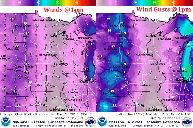
Winds won't be an issue on Wednesday across much of the state, but they do pick up a little across the MN and Dakotas border with gusts approaching 20mph by midday and through the afternoon. The southerly direction will help initiate the warming across the region, which will be gradual, but warmer weather is on the way.
___________________________________________________________________________
Late Week Clipper
A fast moving clipper system develops later this week with light rain changing to light snow from Thursday to Friday. Winds will also increase in the wake of the system on Friday with gusts approaching 30mph. The nice thing is that temperatures don't look to drop in the wake of the storm. In fact, we should see near steady temps with an increase in the temperature department to near 50F by Sunday!
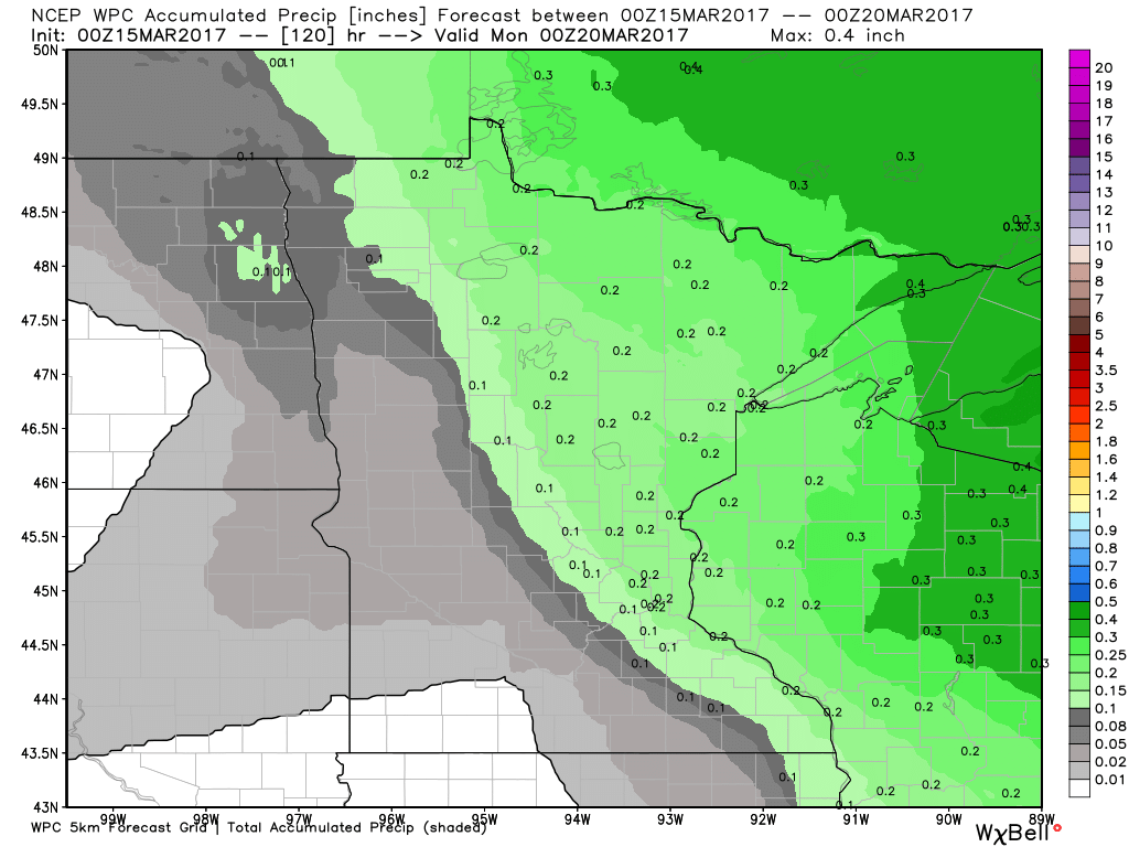
Precipitation Potential Thru Sunday
Our next fast moving clipper system rolls through the region by the end of the week with up to a few tenths of an inch of precipitation across the Arrowhead. Places around the Twin Cities could see 0.1" to 0.2" of liquid over the next few days.
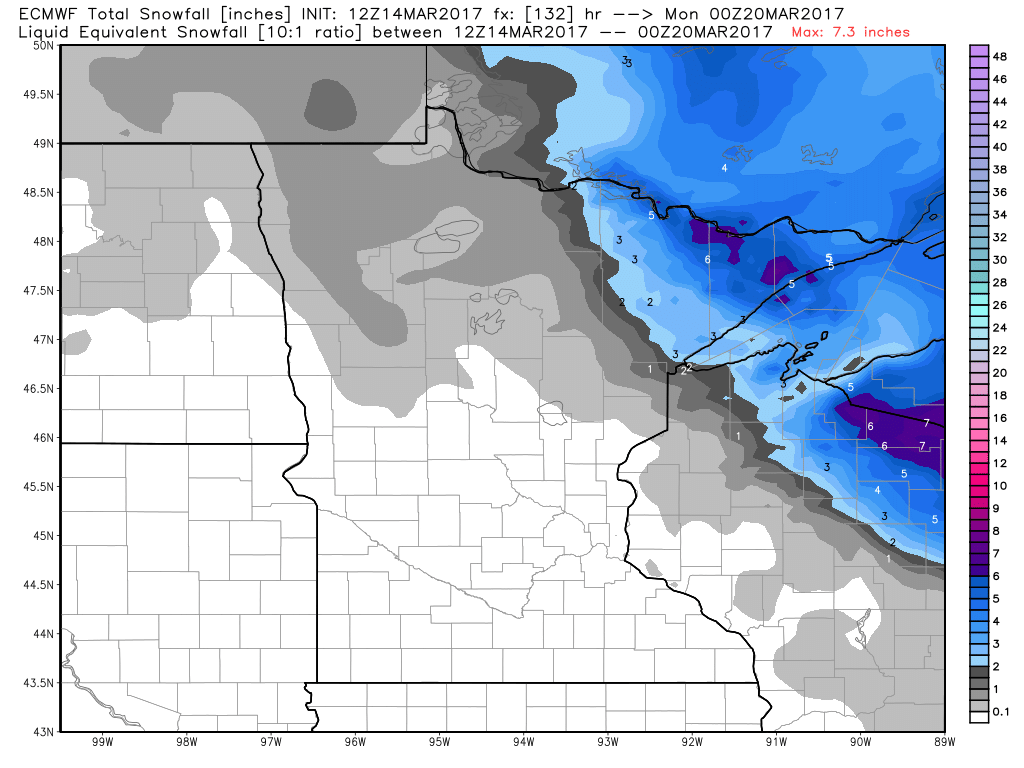
Snowfall Potential
The fast moving storm system may interact with enough cold air to produce a few inches of snow across the Arrowhead over the next few days. In fact, some of this snow could be shovelable!
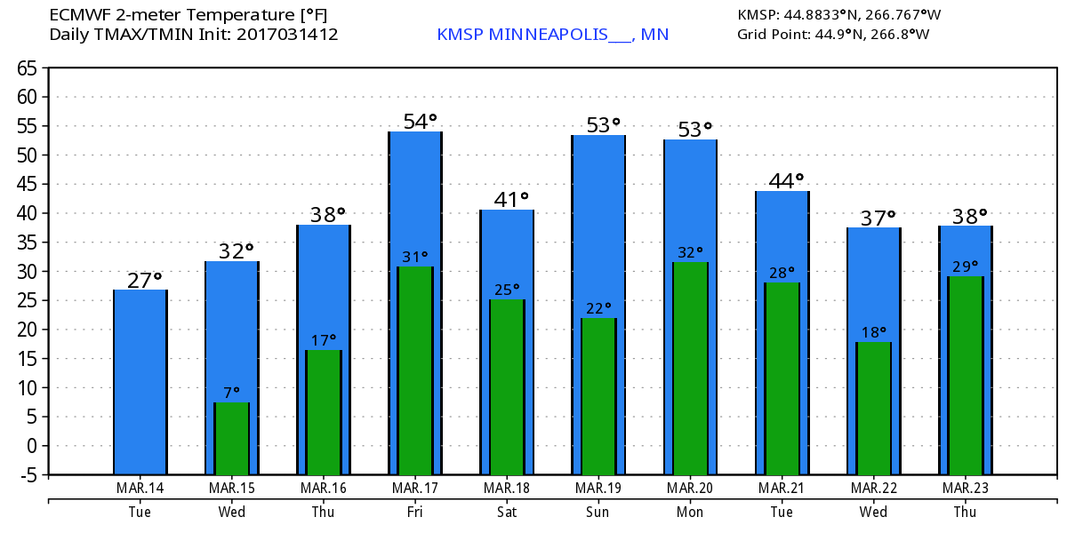
Extended Temperature Outlook for Minneapolis
Here's the temperature outlook through March 23rd, which shows gradually warming temperatures through the end of the week with a few chances of hitting 50F around the weekend. The extended forecast shows readings falling back into the 30s late next week.
 ______________________________________________________________________________
______________________________________________________________________________
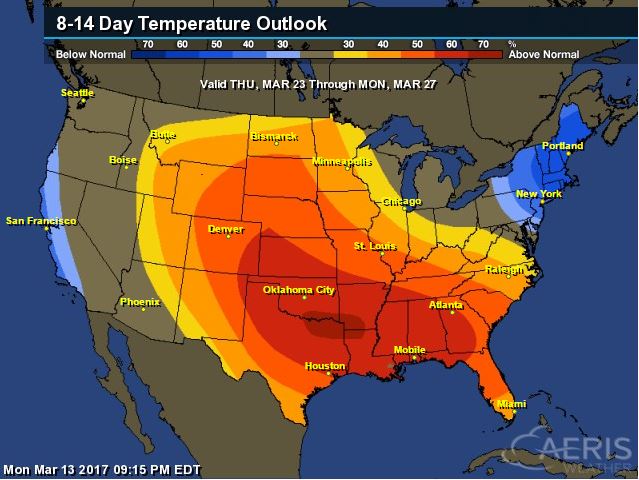
According to NOAA's CPC, the 8 to 14 day temperature outlook suggests warmer than average temperatures moving in across much of the Upper Midwest from March 23rd - 27th. Note that the average high in the Twin Cities through the last week of March is typically in the mid to upper 40s, so if we do happen to get into above average temperatures, readings could be pushing 50F or better!

_________________________________________________________________________________
Temperature Outlook
________________________________________________________________________________
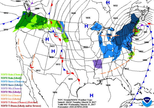
National Weather Outlook
Here's the national weather outlook through the end of the week, which shows the major Northeast storm fading on Wednesday, while a system pushes through the Pacific Northwest and into the Midwest later this week. Meanwhile. The southern half of the country looks to stay mostly quiet with no major severe weather events unfolding anytime soon.
_____________________________________________________________________
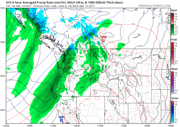
Waves of Pacific Moisture in the Northwest
More rounds of heavier Pacific moisture will continue to push into the Northwest over the next few days with heavier rain along the coast and some mountain snow.
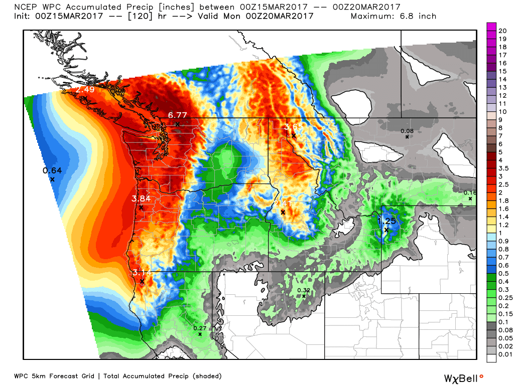
Precipitation in the Northwest
The precipitation potential through PM Sunday suggests that another 3" to 6"+ liquid may be possible across the region. Note that some of the heavier tallies look to be along the coast and in the higher elevations. Flood concerns may come into play here as snow melt and rainfall ramps up.
5 Day Precipitation Forecast
According to NOAA's WPC, the 5 day precipitation forecast suggests widespread 3" to 6"+ precipitation amounts across parts of the Pacific Northwest. Meanwhile, heavy precipitation will wrap up in the Northeast through the midweek time frame with another surge of moisture moving in late week and weekend ahead.
_____________________________________________________________________________
_____________________________________________________________________________
Here's the snowfall potential through the end of next weekend, which shows heavy snow wrapping up in the Northeast through midweek, while pockets of heavy snow develop in the Mountains out west.
_____________________________________________________________________
_____________________________________________________________________
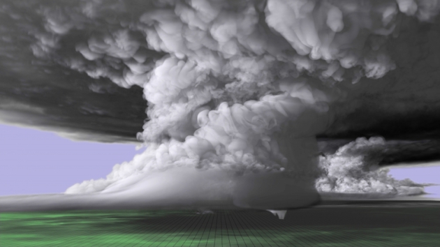
"A scientist and a supercomputer re-create a tornado"
WOW! This is fantastic. Have you ever wanted to see a supercell thunderstorm and an EF-5 tornado? Check out this impressive computer generated tornado. Here's an excerpt from news.wisc.edu: "With tornado season fast approaching or already underway in vulnerable states throughout the U.S., new supercomputer simulations are giving meteorologists unprecedented insight into the structure of monstrous thunderstorms and tornadoes. One such recent simulation recreates a tornado-producing supercell thunderstorm that left a path of destruction over the central Great Plains in 2011."
(A colorized image of the tornado-producing supercell nearly 20 miles long and 12 miles high. The imagery from the simulation was built upon real world data collected near the May 24, 2011 supercell, which spawned several tornadoes including the EF-5 that touched down near El Reno and Oklahoma City, Oklahoma.)
"The slippery slope of climate change"
“We know that the impacts of increases in temperature, floods and sea-level rise trickle down within and across sectors affecting people, assets and our social and economic interactions,” says Dr Lawrence. “And as these changes become more frequent, like heavy rainfall, and as the sea-levels rise and the effects increase from storm surges, we’re going to have less time to recover from them—which will also have cumulative consequences. “We need to make sure that we’re thinking about the interconnections. The impacts themselves cascade, but policy responses can also cascade if the interconnections are not factored in.”
See more from Victoria University of Wellington HERE:
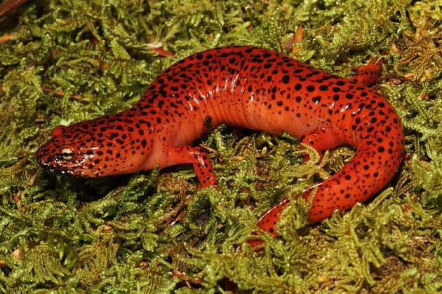
 __________________________________________________________________________"Penn State researchers study salamanders to learn about climate change"
"Researchers at Penn State have taken a unique approach to climate change studies by studying its effects on salamanders, specifically the red-backed salamander. Like all amphibians, salamanders breathe through their skin, which means they require specific habitat conditions in order to survive making them a good choice to study the effects of climate change. Furthermore, the red-backed salamander is the most abundant species in the eastern United States, which means they contribute a large amount of biomass to the environment and can serve as an indicator of forest health. “One of the things we are interested in figuring out is, do they have any evidence of being locally adapted to the climate changes they experience across the range,” Muñoz said. For example, if the salamanders in Virginia are warm-adapted compared to those in Canada, it might be beneficial to introduce those genes to the Canadian populations when considering management options."
See more from the Daily Collegian HERE:
 ______________________________________________________________________________
_______________________________________________________________________________

______________________________________________________________________________
See more from Victoria University of Wellington HERE:
"Researchers at Penn State have taken a unique approach to climate change studies by studying its effects on salamanders, specifically the red-backed salamander. Like all amphibians, salamanders breathe through their skin, which means they require specific habitat conditions in order to survive making them a good choice to study the effects of climate change. Furthermore, the red-backed salamander is the most abundant species in the eastern United States, which means they contribute a large amount of biomass to the environment and can serve as an indicator of forest health. “One of the things we are interested in figuring out is, do they have any evidence of being locally adapted to the climate changes they experience across the range,” Muñoz said. For example, if the salamanders in Virginia are warm-adapted compared to those in Canada, it might be beneficial to introduce those genes to the Canadian populations when considering management options."
See more from the Daily Collegian HERE:
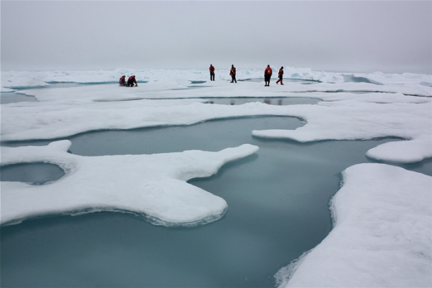
"Arctic Sea Ice May Vanish Even With Climate Goal"
Arctic sea ice may vanish in summers this century even if governments achieve a core target for limiting global warming set by almost 200 nations in 2015, scientists said this week. Arctic sea ice has been shrinking steadily in recent decades, damaging the livelihoods of indigenous peoples and wildlife such as polar bears while opening the region to more shipping and oil and gas exploration. Under the 2015 Paris Agreement, governments set a goal of limiting the rise in average world temperatures to well below 2°C (3.6°F) above pre-industrial times, with an aspiration of just 1.5°C (2.7°F).
(Arctic sea ice and melt ponds in the Chukchi Sea. Credit: NASA/Kathryn Hansen)
_______________________________________________________________________________
"‘Fast radio bursts’ from space might be from aliens, scientists report"
"Astronomers revealed last January the existence of a mysterious type of radio waves coming from space. After studying it closely, they are saying that humans might not be alone in the universe after all. Identified as fast radio bursts (FRBs), astrophysicists from the Harvard-Smithsonian Center for Astrophysics and, Manasvi Lingam at Harvard University, are hinting at a possibility that the waves are coming from alien technological origin."
(An artist’s illustration of the mysterious FRBs. Image: M. Weiss/Center for Astrophysics website)
______________________________________________________________________________
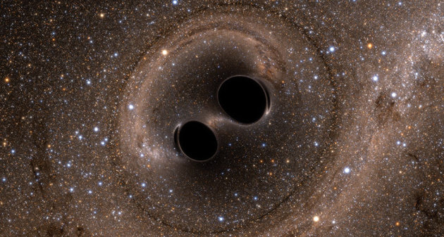
"Gravity waves from black holes verify Einstein’s prediction"
Albert Einstein was pretty brilliant man. He discovered and predicted many things, but how about this? Here's an excerpt from ScienceNews.org: "Albert Einstein predicted gravitational waves in 1916, and researchers finally detected them 100 years later."
(SWEET SUCCESS For the first time, physicists have directly observed gravitational waves, caused by two black holes colliding)
Thanks for checking in and don't forget to follow me on Twitter @TNelsonWX

No comments:
Post a Comment