Sunnier Thursday in Northern Minnesota
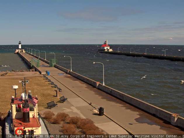
Weather conditions across the northern half of the state were quite a bit brighter Thursday afternoon. Take a look at the beautiful webcam from Canal Park in downtown Duluth, MN.
Visible Satellite on Thursday
While brighter sunshine persisted across the northern half of the state on Thursday, it was cloudy across the southern half of the state. Here's the visible satellite image from Thursday. Note the large lakes of Upper & Lower Red, Leech and Mille Lacs are still bright white, which indicates that they are still ice covered.
 ___________________________________________________________________________
 _____________________________________________________________________
 ___________________________________________________________________________
 ____________________________________________________________________________
______________________________________________________________________
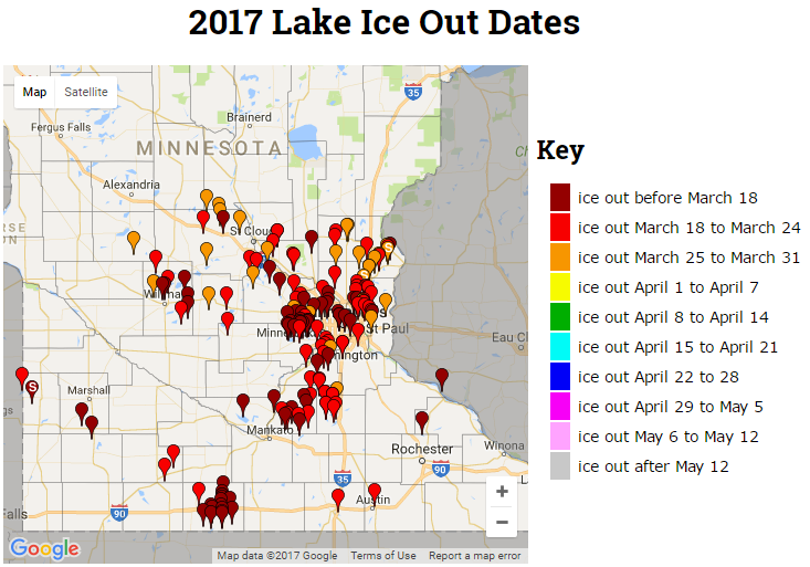
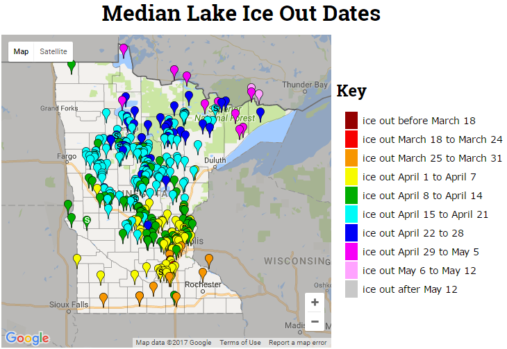
2017 Ice Out Dates
According to the MN DNR, several Minnesota lakes have already gone ice out this year, which is well ahead of normal. Thanks to continued above average this winter and early spring, some lakes have even seen an record early ice out this year! The images below are the current 2017 lake ice out dates and the median lake ice out dates.
Solar Wind Storm
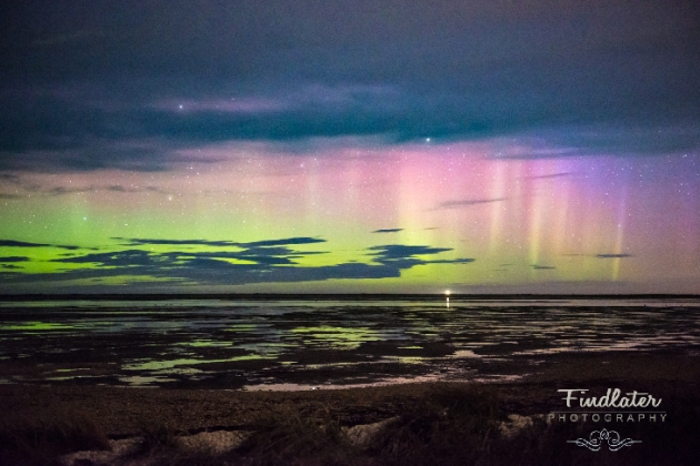
If you've keeping up to date with latest northern lights forecasts and were lucky enough to venture out at the right time with the right weather conditions, you may have had a chance to see the illusive northern lights this week! Here's an excerpt from Spaceweather.com regarding the most recent storm: For the 3rd consecutive day, our planet is inside a stream of fast-moving solar wind flowing from a canyon-shaped hole in the sun's atmosphere. The gaseous material is pressing against Earth's magnetic field with speeds exceeding 600 km/s. Earth's response: A light show around the poles. Last night, Layton Findlater saw the Southern Lights shining through clouds over Invercargill, New Zealand: "Another night of brief but intense auroras," says Findlater. "Hopefully, we can make it three nights running here in the Deep South."
(Image courtesy: Findlater Photography via Spaceweather)
Northern Lights Potential Continues...
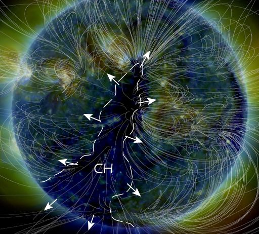
Due to an Earth-facing storm on the sun, northern lights have been quite this week! Here's an excerpt from spaceweather.com from a few days ago, which detailed why northern lights have been so active this week: POTENT CORONAL HOLE FACES EARTH: A canyon-shaped hole in the sun's atmosphere is facing Earth, and it is spewing a stream of fast-moving solar wind toward our planet. NASA's Solar Dynamics Observatory photographed the giant fissure on March 25th: This is a "coronal hole" (CH) -- a vast region where the sun's magnetic field opens up and allows solar wind to escape. A gaseous stream flowing from this coronal hole is expected to reach our planet on during the late hours of March 27th and could spark moderately-strong G2-class geomagnetic storms around the poles on March 28th or 29th. We've seen this coronal hole before. In early March, it lashed Earth's magnetic field with a fast-moving stream that sparked several consecutive days of intense auroras around the poles. The coronal hole is potent because it is spewing solar wind threaded with "negative polarity" magnetic fields. Such fields do a good job connecting to Earth's magnetosphere and energizing geomagnetic storms. Arctic sky watchers should be alert for auroras!
Northern Lights Potential Continues on Friday, March 31st & Saturday, April 1st
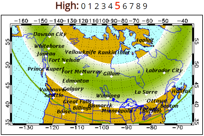
According to the Geophysical Institute at the University of Alaska Fairbanks, the northern lights potential is HIGH for Friday, March 31st and ACTIVE for Saturday, April 1st! Here's their forecast below:
Friday, March 31st: Auroral activity will be HIGH. Weather permitting, highly active auroral displays will be visible overhead from Inuvik, Yellowknife, Rankin and Igaluit to Juneau, Edmonton, Winnipeg, Thunder Bay and Sept-Iles, and visible low on the horizon from Seattle, Des Moines, Chicago, Cleveland, Boston, and Halifax.
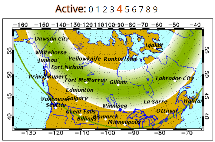
Saturday, April 1st: Forecast: Auroral activity will be active. Weather permitting, active auroral displays will be visible overhead from Inuvik, Yellowknife, Rankin and Igaluit to Juneau, Edmonton, Winnipeg and Sept-Iles, and visible low on the horizon from Vancouver, Great Falls, Pierre, Madison, Lansing, Ottawa, Portland and St. Johns.
______________________________________________________________________
Weather conditions across the country will remain quite active through the weekend and early next week across the Southern US as Pacific storms continue to slide across the country. These storms have been responsible for fairly impressive precipitation amounts in the Western US, including heavy snow in the higher elevations. As they move into the Plains, they become severe weather makers, which has been an ongoing situation since the beginning of the week. Here's the simulated radar through early next week, which shows additional storm systems pushing across the country with more high elevation snow and strong to severe thunderstorm potential.
Several Weather Threats Ahead
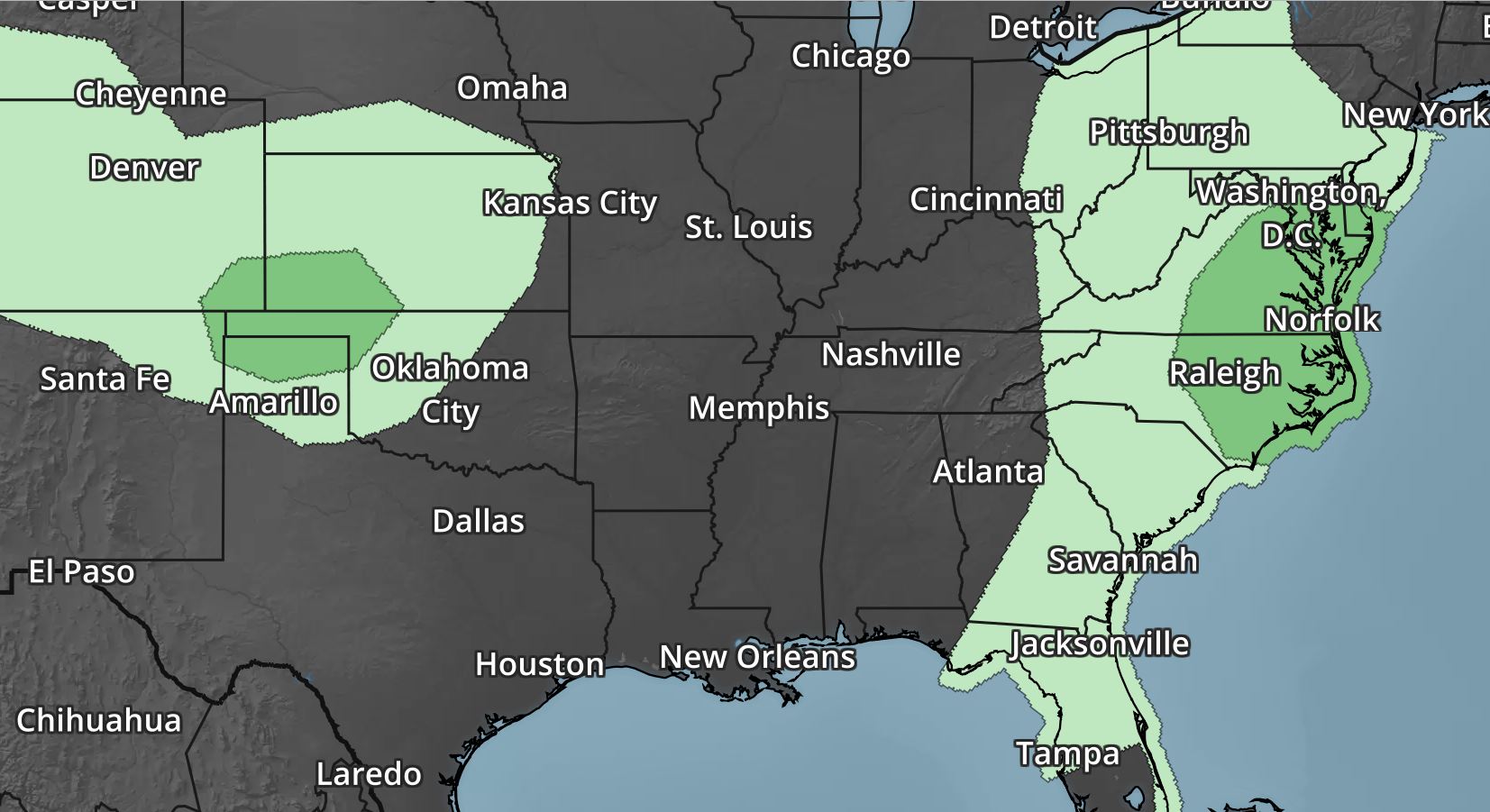
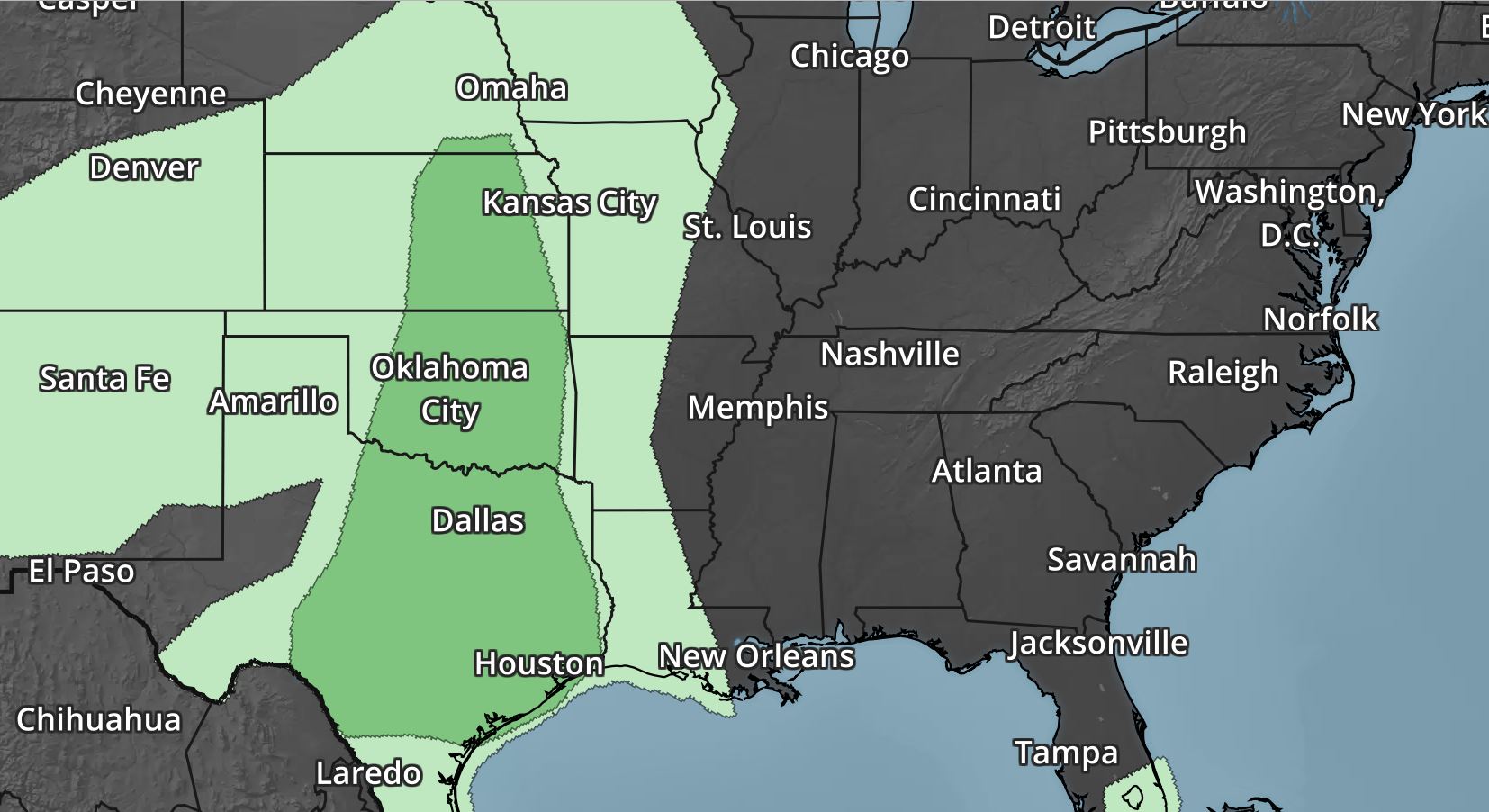
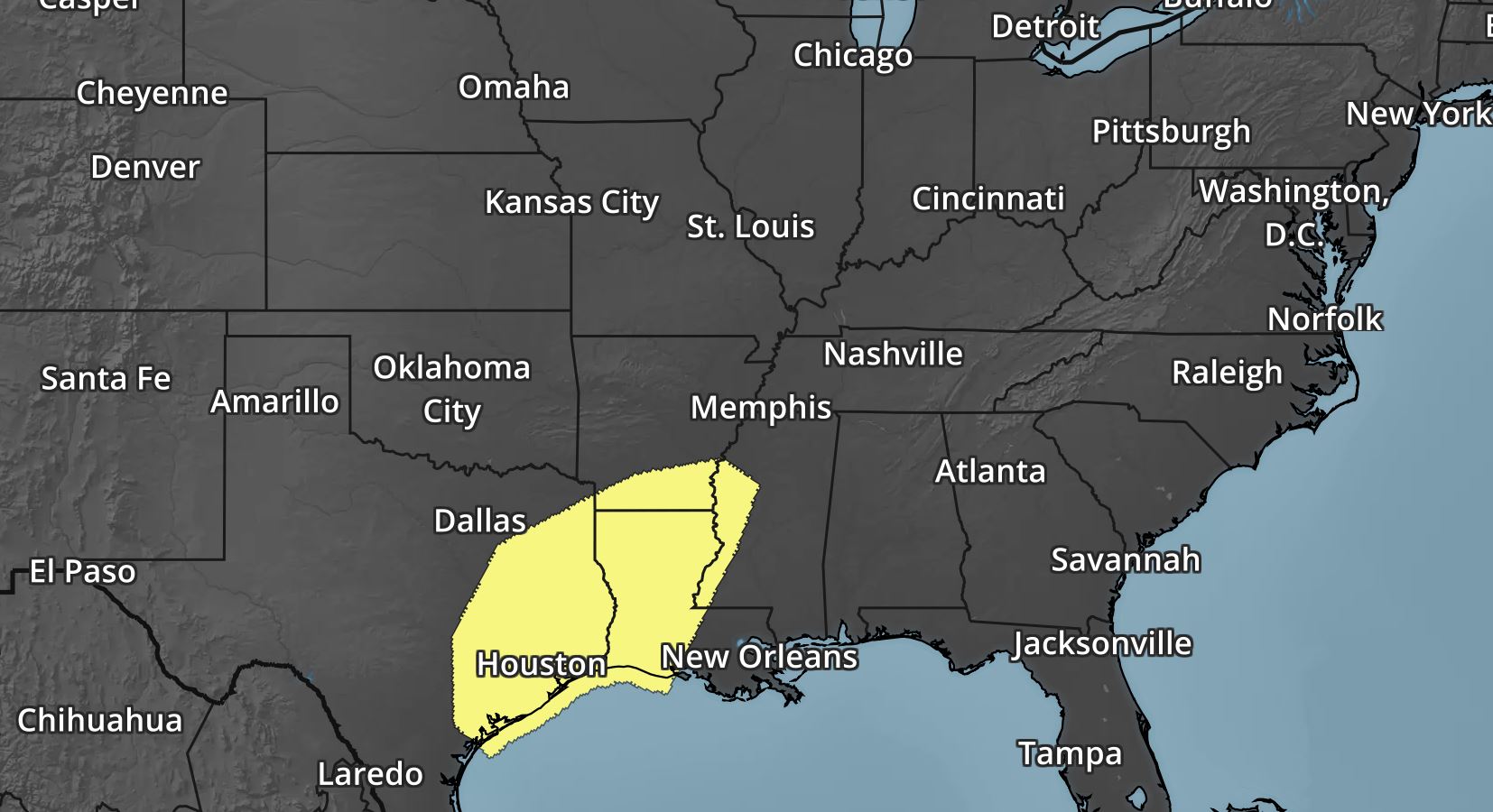
According to NOAA's SPC, the risk of severe weather continues right through the weekend and potentially into early next week. The images below are the severe threats on Friday, Saturday and Sunday respectively. In these particular areas, large hail, damaging winds, isolated tornadoes and locally heavy rainfall will all be possible.
Southern Rainfall Potential
_________________________________________________________________________
2017 PRELIMINARY Tornado Count
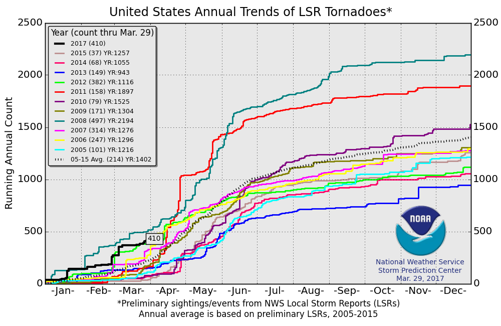
According to NOAA's SPC, the PRELIMINARY tornado count for 2017 is at 410 (thru March 29). Interestingly, this is the highest number of tornado reports (thru March 29th) since 2012 when nearly 500 tornadoes were reported through that time frame. The 2005-2015 average number of tornado reports through March 29th is 214.
 ________________________________________________________________
.gif)
________________________________________________________________________
According to NOAA's SPC, the risk of severe weather continues right through the weekend and potentially into early next week. The images below are the severe threats on Friday, Saturday and Sunday respectively. In these particular areas, large hail, damaging winds, isolated tornadoes and locally heavy rainfall will all be possible.
Southern Rainfall Potential
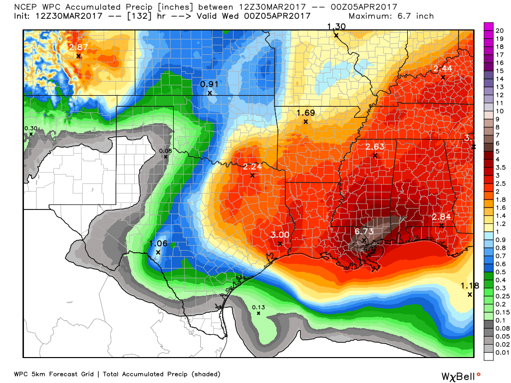
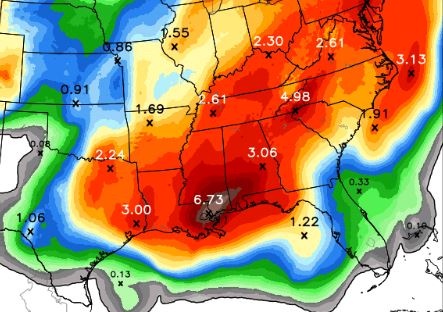
With the threat of strong to severe thunderstorms continuing over the next several days, heavy rainfall will be possible as well. Take a look at the precipitation potential through Tuesday, which suggests some 3" to near 6"+ rainfall tallies across the region, especially along and east of the Mississippi River Valley.
_________________________________________________________________________
2017 PRELIMINARY Tornado Count
According to NOAA's SPC, the PRELIMINARY tornado count for 2017 is at 410 (thru March 29). Interestingly, this is the highest number of tornado reports (thru March 29th) since 2012 when nearly 500 tornadoes were reported through that time frame. The 2005-2015 average number of tornado reports through March 29th is 214.
________________________________________________________________
Late March Snow in the Northeast
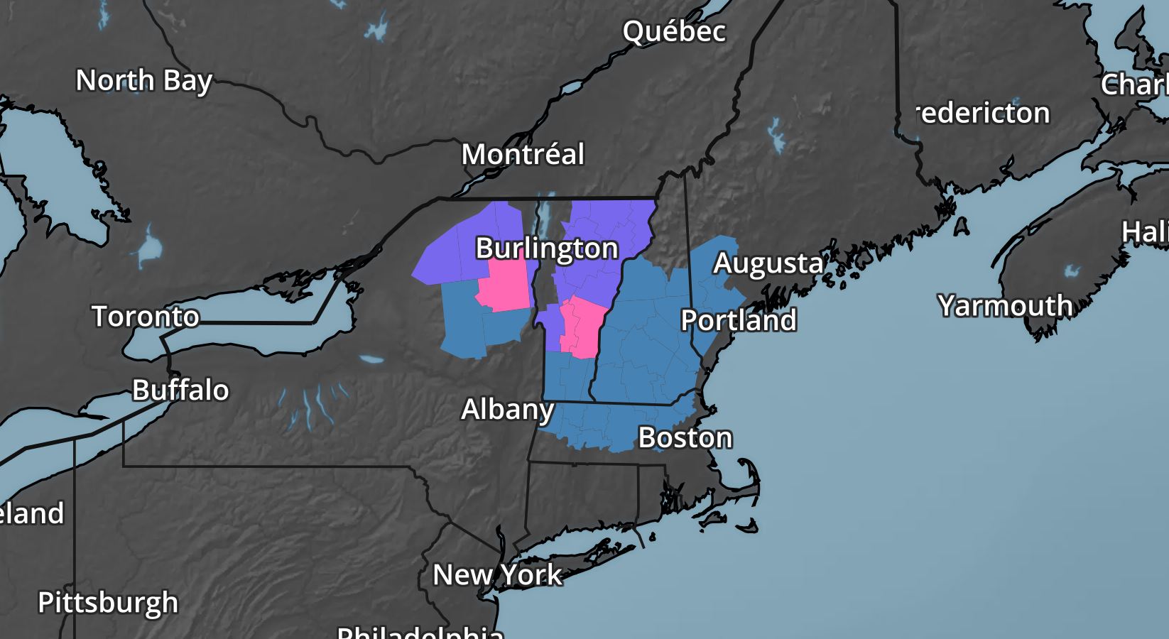
The same storm system responsible for severe weather in the Central US over the past couple of days will be responsible for wintry weather across parts of the Northeast Friday & Saturday. Winter weather headlines have been posted for the potential of 8" to 12" of wet heavy snow that could lead to major travel concerns and even power outages.
Snowfall Potential in the Northeast
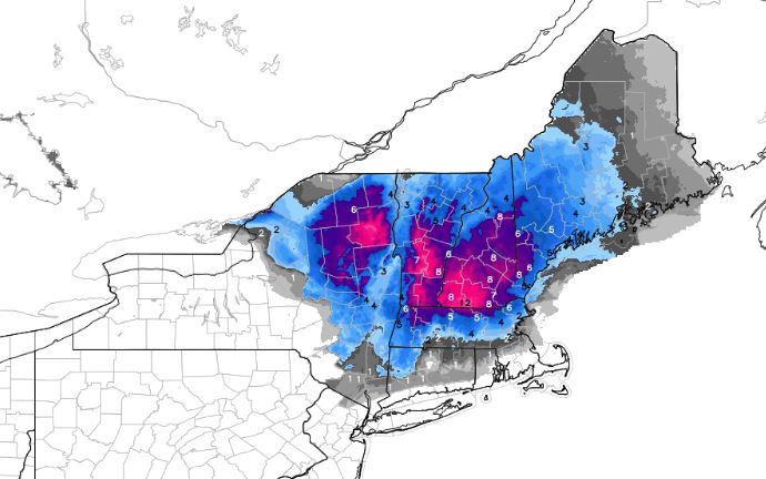
Here's the snowfall potential through Saturday, which suggests a fairly decent 4" to 8" swatch across the region with some 8" to 12" amounts across the higher elevations. The late March snow could be very wet and heavy in spots that could lead to some power outages.
Simulated Radar Through
Here's the simulated radar through early Sunday morning, which suggests the heaviest precipitation moving through the region on Friday and Saturday before tapering late Saturday night. While some across the far north and into the high elevations will see snow, others will see a steady rain, which could accumulated to 1" through Saturday.
Winter Weather Concerns in the Western US
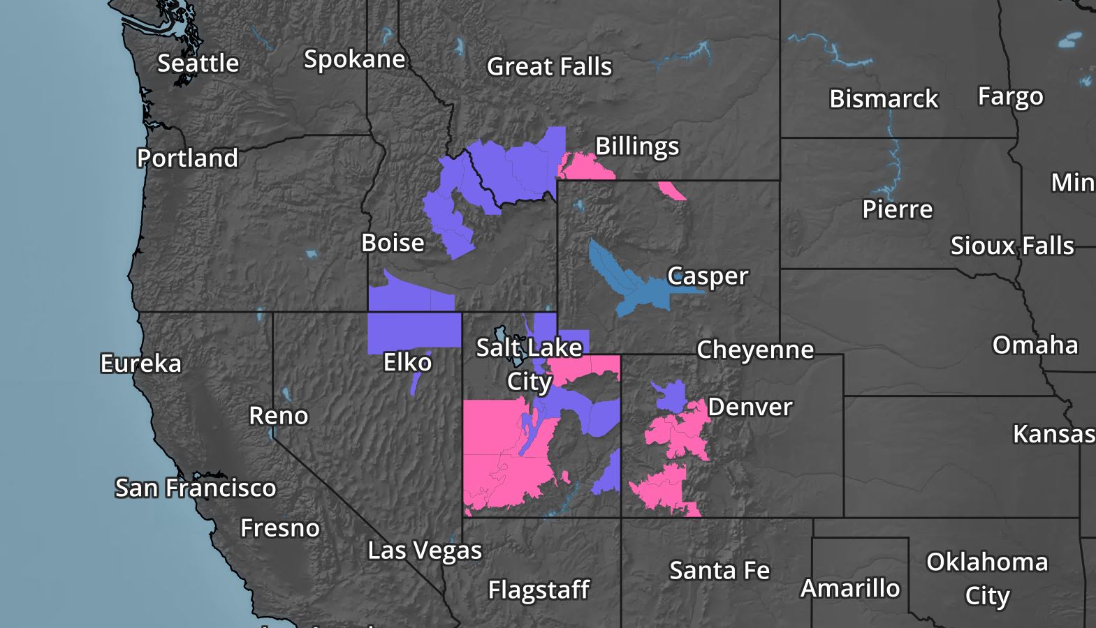
Another storm system will push through the Western US through the first half of the weekend with heavy snowfall potential across the higher elevations. The National Weather Service has issued a number of weather headlines through PM Saturday for snowfall potential of up to 12" or more!
Western Snowfall Potential
Here's the snowfall potential through PM Saturday, which shows heavy snowfall tallies across parts of the Intermountain West. Keep in mind that some of the heaviest amounts could top the 12" mark
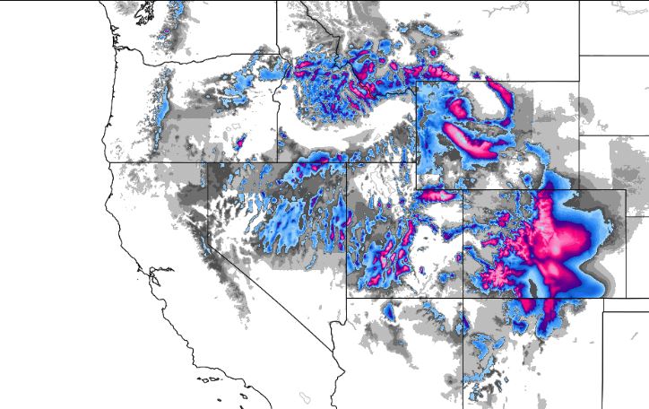
Precipitation Continues in the Western US This Week
Here's the weather outlook through the middle part of next week, which shows two waves of heavier moisture moving through the region. Note that there will be a mix of rain and mountain snow as these systems push through.
________________________________________________________________________
California Snowpack’s Water Content Remains Far above Average
According to the California Department of Water Resources, the California snowpack is running 164% of historical average for March 30th! The average statewide snow water equivalent (SWE) is 45.8" !! WOW, that a lot of water locked up in the snowy mountains! Here's an excerpt from a news release
SACRAMENTO – With every monthly measurement of the California snowpack this winter, the state’s rebound from the previous five years of drought becomes more evident. Today’s electronic readings from 95 sites in the Sierra Nevada show an average statewide snow water equivalent (SWE) of 45.8 inches, or 164 percent of the historical average for March 30 (27.9 inches).
Today’s manual snow survey by the Department of Water Resources (DWR) at Phillips Station in the Sierra Nevada found a SWE of 46.1 inches, 183 percent of the late March/early April long-term average at Phillips (25.2 inches). The three previous 2017 surveys at Phillips near the beginning of March, February and January found an SWE of 43.5 inches for March, 28 inches for February and 6 inches for January. SWE is the depth of water that theoretically would result if the entire snowpack melted instantaneously. That measurement is more important than depth in evaluating the status of the snowpack. On average, the snowpack supplies about 30 percent of California’s water needs as it melts in the spring and early summer. Electronic measurements indicate the water content of the northern Sierra snowpack is 40.8 inches, 147 percent of the multi-decade March 30 average. The central and southern Sierra readings are 50.5 inches (175 percent of average) and 43.9 inches (164 percent of average), respectively. Dr. Michael Anderson, State Climatologist, observed: “Although the record pace of the snowpack accumulation fell off significantly in March, California enters the snowmelt season with a large snowpack that will result in high water in many rivers through the spring." The Phillips snow course, near the intersection of Highway 50 and Sierra-at-Tahoe Road, is one of hundreds surveyed manually throughout the winter. Manual measurements augment the electronic readings from about 100 sensors in the state’s mountains that provide a current snapshot of the water content in the snowpack. Frank Gehrke, chief of the California Cooperative Snow Surveys Program, conducted DWR’s survey today at Phillips and said of his findings, "The storm track shifted away from California during March, but we still have a very substantial snowpack, particularly in the higher elevations in the central and southern Sierra. This is an extremely good year from the snowpack standpoint,” he said, adding that this year’s snowpack ranks in the upper quarter of historic snowpacks and is providing “great reservoir recovery.” Many Californians continue to experience the effects of drought, and some Central Valley communities still depend on water tanks and bottled water. Groundwater – the source of at least a third of the supplies Californians use – will take much more than even an historically wet water year to be replenished in many areas.
__________________________________________________________________________
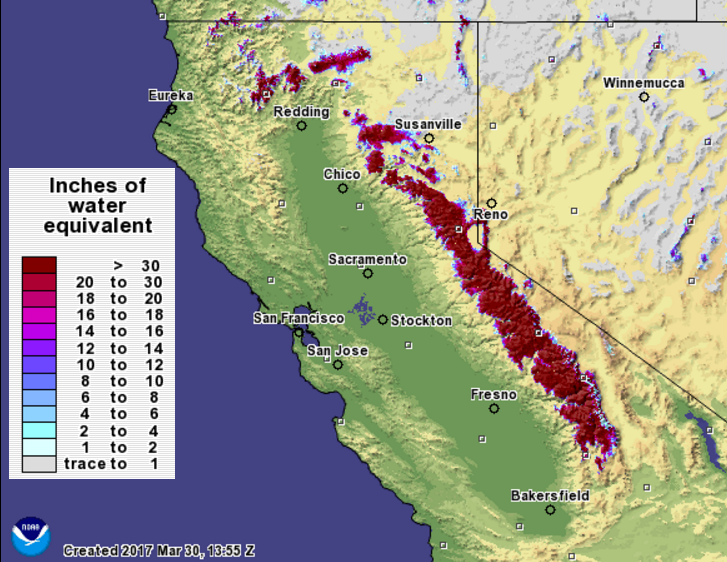
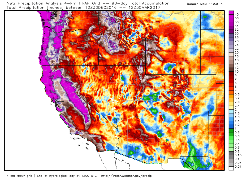
Precipitation Last 90 Days
Here's an interesting map! The radar estimated precipitation over the last 90 days suggests that nearly 40"+ of liquid precipitation has fallen across parts of the Western US since the end of December 2016! A steady stream of Pacific moisture earlier in the year really helped to boost precipitation values across the region.
____________________________________________________________________________
__________________________________________________________________________
Precipitation Last 90 Days
Here's an interesting map! The radar estimated precipitation over the last 90 days suggests that nearly 40"+ of liquid precipitation has fallen across parts of the Western US since the end of December 2016! A steady stream of Pacific moisture earlier in the year really helped to boost precipitation values across the region.
____________________________________________________________________________
Steady Stream of Pacific Moisture
The precipitable water loop from the Eastern Pacific shows plumes of highly concentrated water moving into the West Coast. These streams are and will continue to be responsible for fairly decent amounts of precipitation over the next several days.
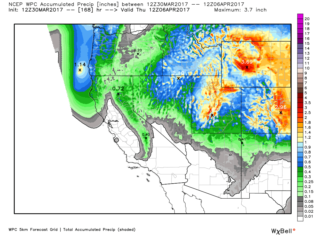
Western Precipitation Potential
Here's a look at the precipitation potential through the middle part of week, which shows some of the heaviest precipitation across parts of the Central Rockies, but there also appears to be some additional moisture across parts of the Sierra Nevada Range and along the coast of northern California to Oregon and Washington.
____________________________________________________________________________
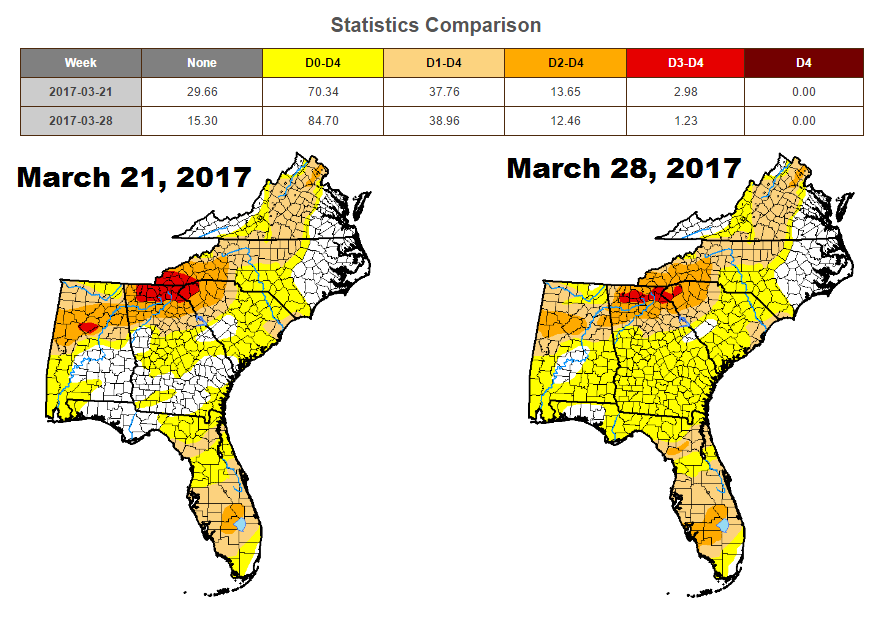
Drought Worsens in the Southeast
According to the US Drought Monitor, drought conditions in the Southeast continue to intensify. While EXTREME drought conditions have decreased from nearly 3% to a little more than 1%, more of the area under abnormally dry conditions going from 70% last week to nearly 85% this week.
Rainfall Potential in the Southeast
The good news is that active weather conditions will help bring the potential of widespread heavy rainfall to the region through early next week. According to the 5 day precipitation forecast, some spots from new New Orleans, LA to the Mid-Atlantic States could see as much as 2" to 4" of rain with isolated spots seeing nearly 5" to 6"+!
_____________________________________________________________________________
By Todd Nelson, filling in for Douglas
Happy last day of March 2017! Are you sad to see it go? It has been in interesting month, no question. From our earliest Minnesota tornado(es) on record (March 6th) to a persistent southerly storm track keeping snowfall amounts down, March 2017 has been a memorable one.
Note that March is typically the 3rd snowiest month for the Twin Cities, which averages a little more than 10 inches. This year, we are running a deficit of nearly 5 inches, bringing our seasonal snowfall deficit to a little more 20 inches. Snow shovels across Central Minnesota were cheated this year, while those in southern Minnesota were put to extra use. Rochester, MN has seen more than 50 inches of snow this season, nearly 5 inches above average.
Average temps in the Twin Cities were running below average through mid March, but have since warmed. It'll be close, but March 2017 will likely end up being the 19th consecutive month with above normal temps! Unreal.
Mild sunshine will brighten spirits Friday. Clouds thicken Saturday and give to showers Sunday.
______________________________________________________________________________
Extended Forecast:
THURSDAY NIGHT: Mostly cloudy, drying out. Winds: NE 5. Low: 33
FRIDAY: Sun returns! Feels warm again. Winds: NE 5-10. High: 53.
FRIDAY NIGHT: Partly cloudy and chilly. Winds: NNE 5. Low: 34.
SATURDAY: Hazy sun. Mild temps. Winds: ESE 5. High: 58.
SUNDAY: Mostly cloudy with scattered showers. Winds: SE 5-15. Wake-up: 40. High: 55.
MONDAY: Soggy start. Clearing through the day, but dry for Twins Home Opener. Winds: NNW 5-10. Wake-up: 41. High: 59
TUESDAY: Clouds thicken late. A few PM showers. Winds: ENE 10-15. Wake-up: 40. High: 58
WEDNESDAY: Breezy. Steady rains across S. MN. Winds: NNE 10-20. Wake-up: 40. High: 52.
THURSDAY: Cooler breeze. Slow clearing. Winds: NNW 10-20. Wake-up: 35. High: 50.
_______________________________________________________________________________
_______________________________________________________________________________
This Day in Weather History
March 31st
March 31st
1896: A strong snowstorm dumps 13.5 inches of snow at Maple Plain. Vivid lightning is also in the storm with 10-12 flashes per minute. Visibility was down to less than one block. The high temperature was 57 at Maple Plain the day before.
1843: The low temperature at Ft. Snelling plummets to -11.
_______________________________________________________________________________
_______________________________________________________________________________
Average High/Low for Minneapolis
March 31st
March 31st
Average High: 49F (Record: 82F set in 1986)
Average: Low: 30F (Record: -1F set in 1969)
Average: Low: 30F (Record: -1F set in 1969)
*Record Snowfall: 14.7" set in 1985
_______________________________________________________________________________
_______________________________________________________________________________
Sunrise Sunset Times For Minneapolis
March 31st
March 31st
Sunrise: 6:55am
Sunset: 7:40pm
Sunset: 7:40pm
*Daylight Gained Since Yesterday: ~3 minutes & 7 seconds
*Daylight Gained Since Winter Solstice (December 21st): ~4 hours & 1 minute
________________________________________________________________________________
*Daylight Gained Since Winter Solstice (December 21st): ~4 hours & 1 minute
________________________________________________________________________________
Moon Phase for March 30th at Midnight
3.2 Days Since New Moon
3.2 Days Since New Moon
________________________________________________________________________________
Weather Outlook For Friday
After a couple of cloudy days across parts of the state, the sun will return Friday, which will help to boost temperatures into the 50s! A lighter breeze may help to keep temperatures down a bit, but with the sun as strong as it is now, it will feel quite warm Friday afternoon!
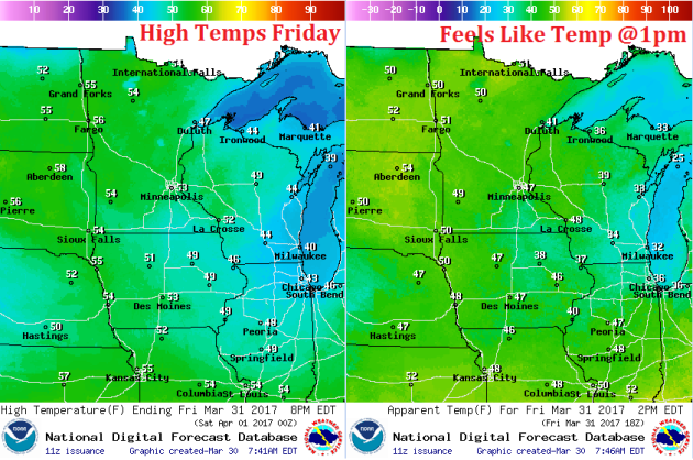
Weather Outlook For Friday
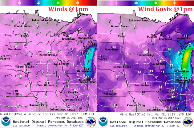
Winds on Friday will be fairly light across much of the region, but could get up close to 10mph to 15mph across parts of southern Minnesota on Friday afternoon. All and all, Friday will be a very enjoyable day with more sunshine, mild temperatures and a light breeze.
Here's the weather outlook for Friday, which shows mostly dry and mostly sunny weather conditions across the region. There maybe a few more clouds across the extreme southeastern and northwestern part of the state, but Friday looks very quiet.