Visible Satellite on Saturday
Here's the visible satellite loop from early Saturday, which showed a fairly gray start to our weekend. It took some time, but the sun finally popped out! It actually turned out to be a pretty nice afternoon with sunshine, less wind and temperatures slightly above average.
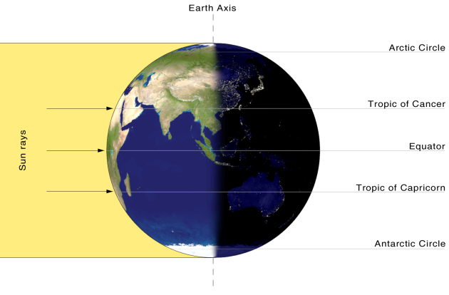
On Monday, March 20th at 5:29AM, the sun's most direct rays will be shining over the equator marking the beginning of spring in the northenr hemisphere and the beginning of fall in the southern hemisphere. Note that the entire globe sees around 12 hours of daylight with the greatest increase in daylight occurring near the north pole. Get this, Barrow, Alaska is gaining a little more than 9 minutes of daylight right now, while Fairbanks, Alaska is gaining nearly 7 minutes of daylight. Happy Spring!!
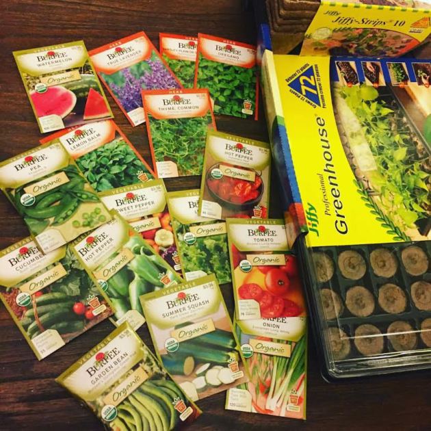
Thanks my good friend Kaley Jacobson for the picture below who is about ready to start planting seeds for the 2017 summer garden! While it's a bit too early to start most seeds, some can be planted now!
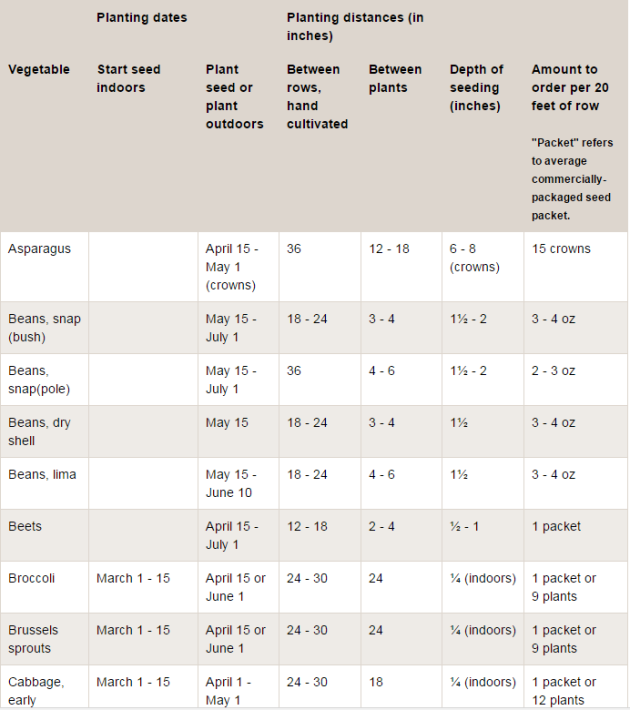
If you're wondering when and what you can plant over the next few weeks, here a great seed planting guide from the University of Minnesota. Note that most seeds shouldn't be planted quite yet, but things like broccoli, cabbage, eggplant and peppers can be! And we're still a few weeks away from getting those tomato seeds going.
See the full list of vegetable dates and much from the UofM HERE:
Well how about this... The Minnesota Landscape Arboretum in Chanhassen, MN is in the running for the best botanical garden in the country!! There's still time left to vote.
"Visitors to the Minnesota Landscape Arboretum enjoy more than 1,200 acres of manicured gardens, woods and prairies, accessible via 12.5 miles of walkable trails and garden paths. The vast space, divided into 28 named gardens and 45 plant collections, showcases more than 5,000 plant species and varieties. Highlights include a Japanese Garden, Daylily and Chrysanthemum Walk, Kitchen Herb Garden, Maze Garden and Peony Walk."
Check out the full list from USA TodayHERE:
(Photo courtesy of Don Olson, Minnesota Landscape Arboretum Photographers Society)

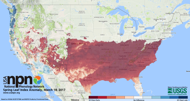
According to the National Phenology Network, spring has already sprung across a good chunk of the nation. In fact, much of the southern half the country is already reporting "the appearance of the first tiny leaves on the trees, or the first crocus plants peeping through the snow. The Spring Leaf Index is a synthetic measure of these early season events in plants, based on recent temperature conditions."
The image below is the spring leaf anomaly, which shows that spring is still running nearly nearly 2 weeks or more ahead of schedule!
See more from USA NPN Here:
The numbers are in from NOAA and the Globe had it's second warmest February, season and year to date on record! Here's an excerpt from NOAA: "The globally averaged temperature over land and ocean surfaces for February 2017 was the second highest for the month of February in the NOAA global temperature dataset record, which dates back to 1880. The December–February seasonal and year to date global temperatures were also second warmest on record."
"Selected Significant Climate Anomalies and Events for February 2017"
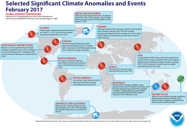
February 2017
The February temperature across global land and ocean surfaces was 1.76°F above the 20th century average of 53.9°F. This was the second highest for February in the 1880–2017 record, behind 2016.
The February globally averaged land surface temperature was 3.20°F above the 20th century average of 37.8°F. This value was also the second highest February land global temperature in the record, trailing behind 2016.
The February globally averaged sea surface temperature was 1.24°F above the 20th century monthly average of 60.6°F—the second highest global ocean temperature for February in the record, behind the record year 2016.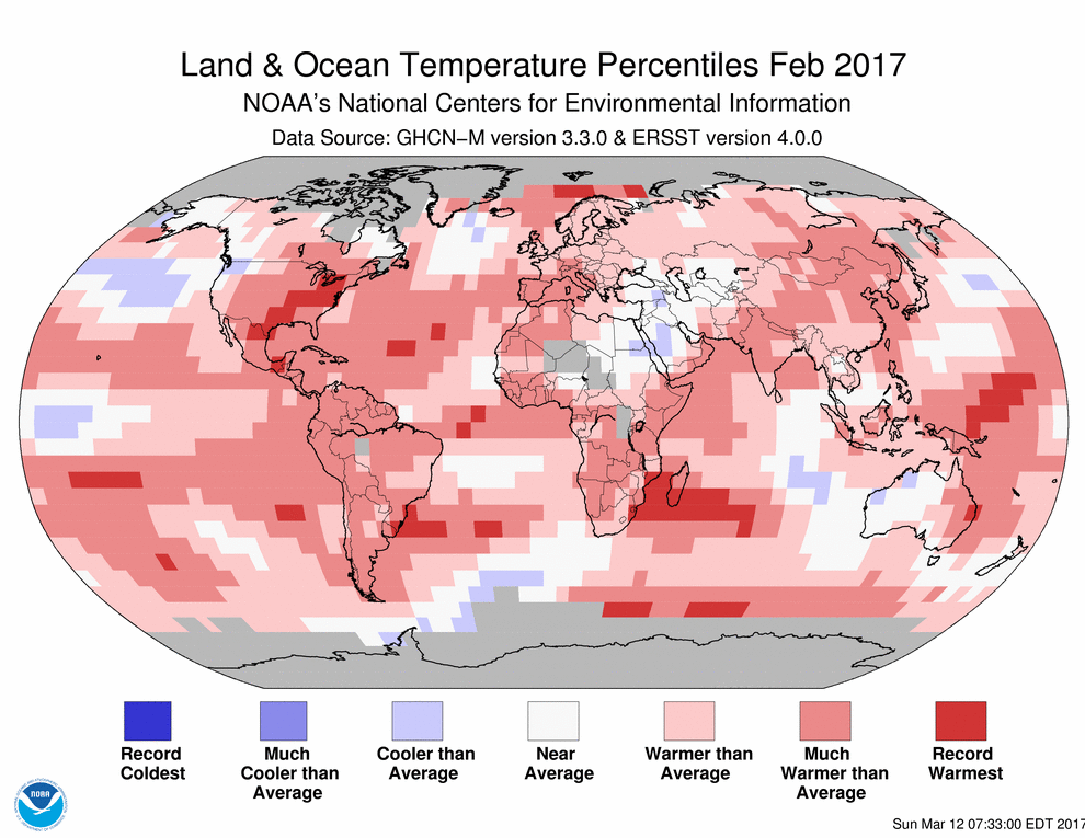
Winter Season: December 2016 to February 2017
The December–February average temperature across global land and ocean surfaces was 1.60°F above the 20th century average of 53.8°F. This was the second highest for December–February in the 1880–2017 record, trailing behind 2015/16.
The globally averaged land surface temperature for December–February was 2.74°F above the 20th century average of 37.8°F. This was the second highest for December–February in the record, behind 2015/16.
The December–February globally averaged sea surface temperature was 1.19°F above the 20th century average of 60.5°F – also the second highest for December–February in the record, behind the record set during 2015/16.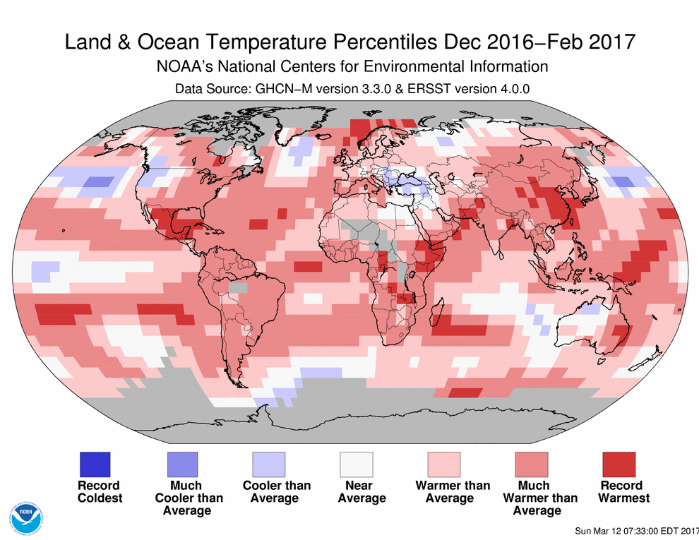
___________________________________________________________________________
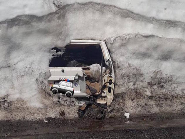
Dude, where's my car? Oh there it is! How about this story from out of California? A snow-removal vehicale was clearing roads in the Donner Pass and slammed into a Jeep that was buried under nearly 20ft of snow! Here's an excerpt from 3NewsNow.com: California Highway Patrol officers made a surprising discovery in the Donner Pass last week. Officers found a Jeep Cherokee buried under about 20 feet of snow near the town of Truckee in the Sierra Nevada mountain range. A snow-removal vehicle was being used to clear the roads when it slammed into the abandoned Jeep. A stunning photo posted by the California Highway Patrol's Truckee division shows the vehicle's back end exposed amid a wall of snow.
See the full story from 3NewsNow.com HERE:
(Calif. Highway Patrol Truckee / Facebook)
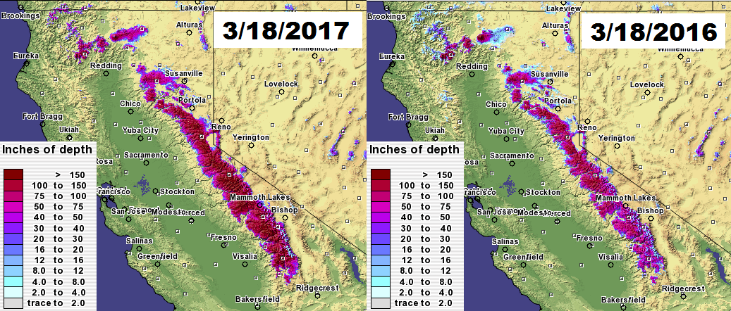
Take a look at the snow comparison from March 18th, 2016 vs March 18th, 2017. Note how much snow there is in the Sierra Nevadas this year! If you read the story above, the California Highway Patrol was reporting nearly 20ft in spots in the Donner Pass! WOW!
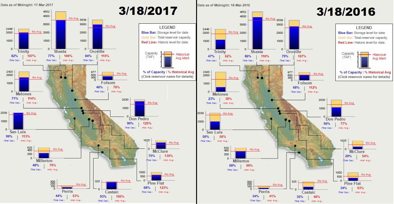
California Reservoir Levels 2017 vs 2016
Reservior levels have certainly been coming up over the last several weeks/months, which is good news! Note that levels were quite a bit lower last year across much of the state, especially across southern California.
Rain in California Next Week
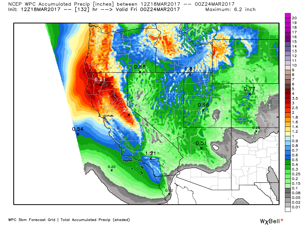
Here's the weather outlook from Tuesday to Thursday, which shows another round of precipitation working into the Western US with some fairly decent precipitation tallies. Note that rain will be found in the lower elevations, while areas of heavier snow may be found in the higher elevations.
Here's a look at the precipitation potential through late next week, which shows another round of heavy precipitation moving through the Western US. Some spots could see as much as 3" to 6"+ of liquid.
____________________________________________________________________________
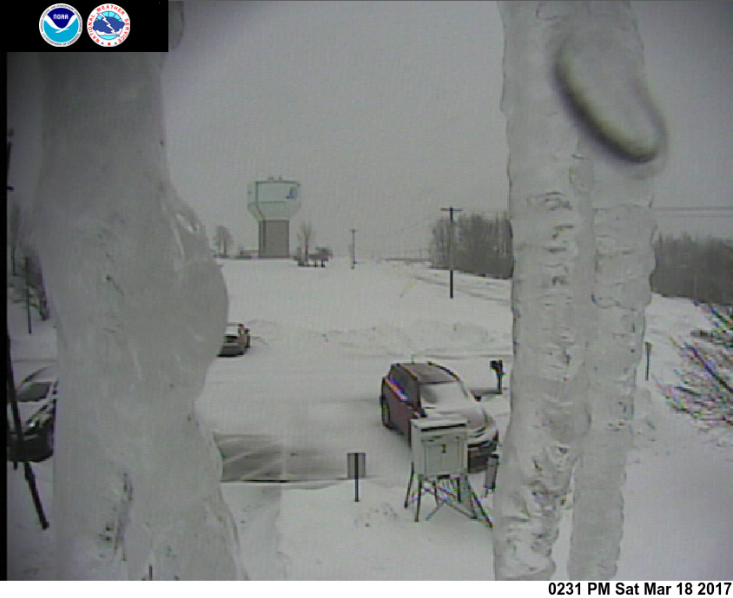
Parts of the Northeast have been getting some pretty wild weather as of late. Take a look at the very wintry webcam from the National Weather Service office in Binghamton, NY on Saturday afternoon. While snow was flying across parts of the Northeast this weekend, any snowfall accumulations will be fairly light and nowhere near what we had earlier last week!
_______________________________________________________________________
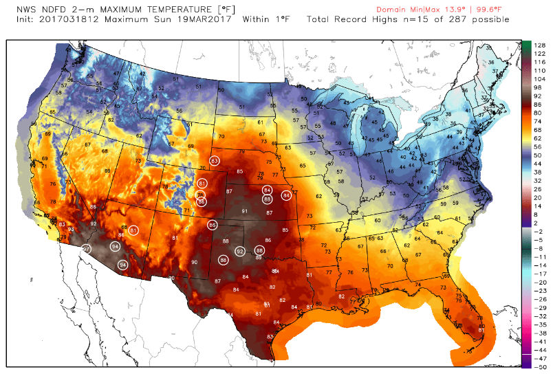
High Temperatures From Average Sunday
Here's a look at high temperatures from average on Sunday. Note that while temperatures remain a little cooler than average in the Eastern US, temperatures in the Central and Southwestern US will be well above average! Note that some locations across the Plains will be nearly 30F+ above average!

Record Warmth Continues...
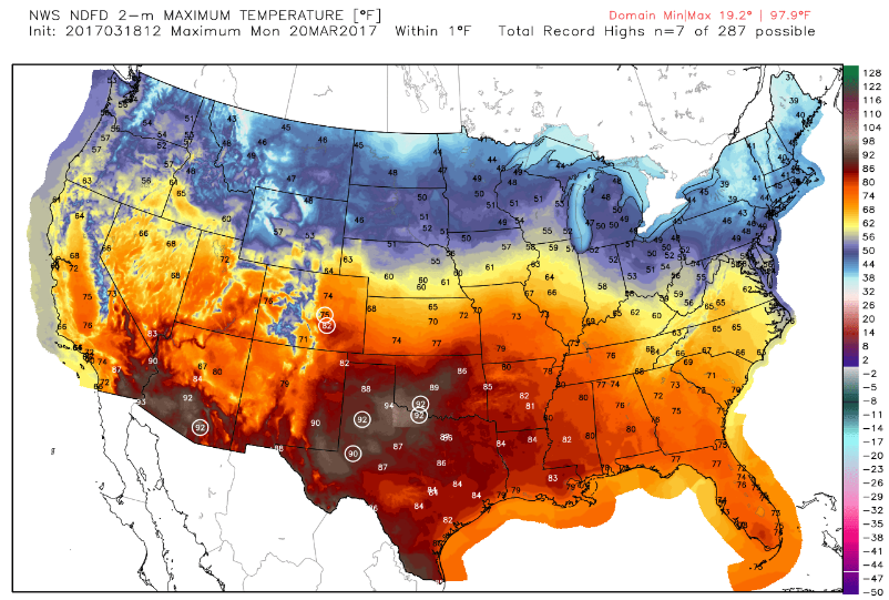
With temperatures running nearly 30F+ above average across the Plains, record high temperatures may be possible there. Take a look at the 2 images below, which show the potential record highs (circled numbers) that could be set on Sunday and Monday respectively.
________________________________________________________________________________
Last Day of Winter 2017. A shot at 60 degrees?
By Todd Nelson, filling in for Douglas.I don't know about you, but I am ready to wash my hands of what has been a pretty pitiful winter. Consistently warmer than average temperatures and a number of near misses has allowed the Twin Cities to rack up a 17 inch snowfall deficit this season. My kids are bummed and think it's my fault they didn't get to play in the snow enough this year. Sorry boys. I'll do better next year, I promise. Trust me, I'm a weatherman...
Speaking of warm, it'll feel like April on Sunday with breezy south winds and highs in the 50s. I wouldn't doubt it if a few locations in southwestern Minnesota hit 60 degrees! Not bad for the last full day of winter, I'll take it!
A storm system is still in the works later this week, but with temperatures flirting with 50 degrees, it appears that rain will be the predominate precipitation type as it blows through.
The extended forecast looks a little more active through the end of March, but with the way the things are going, I'm not sure snow is in our favor. Like I said, I already ditched the shovel.
___________________________________________________________________________________
Extended Forecast:
SATURDAY NIGHT: Mostly clear and quiet. Winds: SE 5. Low: 31.
SUNDAY: Mild and breezy. Few showers late. Winds: SSW 10-20. High: 57
SUNDAY NIGHT: Mostly cloudy. Winds: NNW 10-15. Low: 36
MONDAY: Happy spring! More sun, still mild. Winds: N 5-10. High: 52
TUESDAY: Partly cloudy, cooler breeze. Winds: N 5-10. Wake-up: 28. High: 42.
WEDNESDAY: Near average temps. Dry. Winds: SE 4-15. Wake-up: 20. High: 42.
THURSDAY: Cloudy. Steady rain develops. Winds: SE 10-20. Wake-up: 30. High: 45.
FRIDAY: Windy. Rain changes to snow late. Winds: NNW 15-25. Wake-up: 34. High: 52.
SATURDAY: Drying out. Gradual clearing. Winds: ENE 5-10. Wake-up: 34. High: 49.
_______________________________________________________________________________
_______________________________________________________________________________
This Day in Weather History
March 19th
March 19th
2012: This is the 4th day in a row that the Twin Cities reaches at least 79 degrees, and the 8th record high in a 10 day span.
1977: An energy emergency finally ends in Minnesota. It was caused by the extended cold.
_______________________________________________________________________________
_______________________________________________________________________________
Average High/Low for Minneapolis
March 19th
March 19th
Average High: 43F (Record: 79F set in 2012)
Average: Low: 25F (Record: -15F set in 1875)
Average: Low: 25F (Record: -15F set in 1875)
*Record Snowfall: 8.8" set in 1943
_______________________________________________________________________________
_______________________________________________________________________________
Sunrise Sunset Times For Minneapolis
March 19th
March 19th
Sunrise: 7:17am
Sunset: 7:24pm
Sunset: 7:24pm
*Daylight Gained Since Yesterday: ~3 minutes & 9 seconds
*Daylight Gained Since Winter Solstice (December 21st): ~3 hours & 21 minutes
________________________________________________________________________________
*Daylight Gained Since Winter Solstice (December 21st): ~3 hours & 21 minutes
________________________________________________________________________________
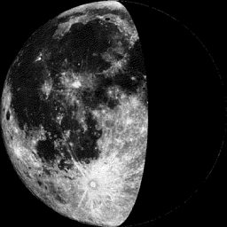
Moon Phase for March 18th at Midnight
1.4 Days Before Last Quarter
1.4 Days Before Last Quarter
________________________________________________________________________________
Weather Outlook For Sunday
High temperatures across the region on Sunday will be very warm! In fact, temperatures across Minnesota will be running nearly 10F to 20F above average with highs in the 50s across much of the state and even a shot at 60F across parts of southwestern MN! There will definitely be a hint of April in the air on Sunday.
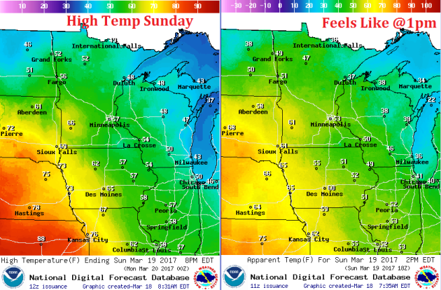
Weather Outlook For Sunday
Mild temperatures will come by way of stronger winds on Sunday. Unfortunately, a strong southerly wind will be sustained at 10-15mph with gust to 25mph-30mph at times. Hold onto your hat!
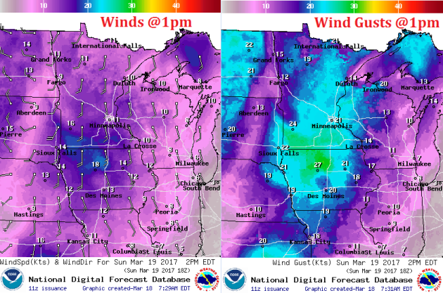
Sunday's warm and breezy weather will come ahead of a cool front that will push through the region late in the day. A few light rain showers could pop up across northern Minnesota as the front slides through.