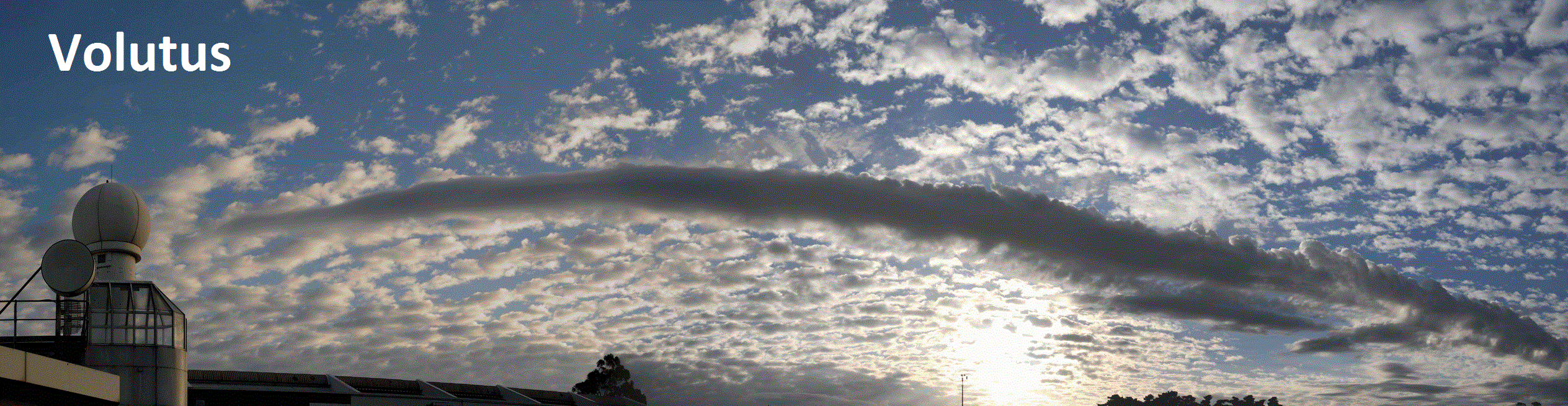
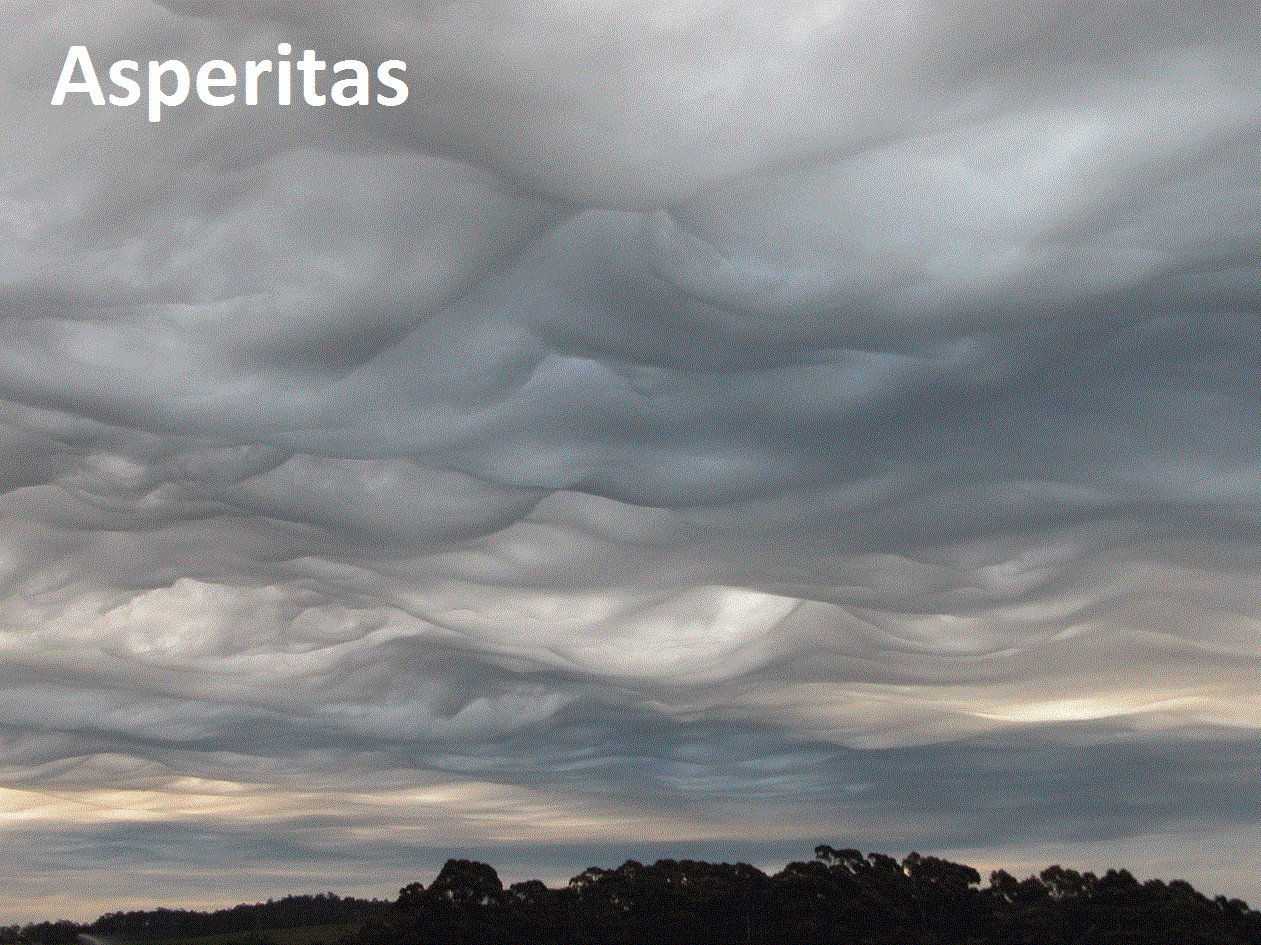
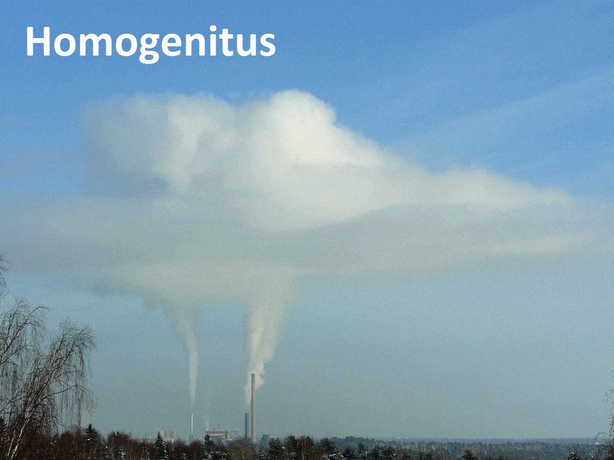
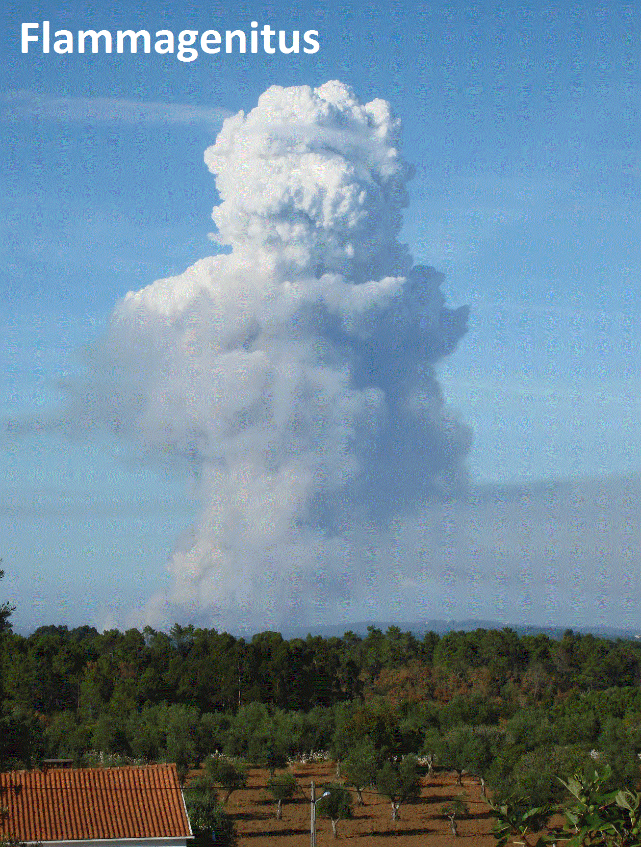
New Cloud Types Defined by WMO. The UK Met Office has details: "The cloud species Volutus has been officially named as a new species of cloud in the World Meteorological Organization’s Cloud Atlas. The new cloud species name will now be used by meteorologists operationally around the world. As well as a new species, several new ‘special clouds’ and supplementary features of existing cloud types have been officially recognised in the atlas which is the official publication of cloud types. It is used as a reference document by operational meteorologists around the world and is also an important training tool for meteorologists, as well as for those working in aviation and at sea. Special clouds named in the new edition include: Flammagenitus, which are clouds formed as a result of forest fires; and Homogenitus, which denotes man-made or anthropogenic clouds such as those which form over power station cooling towers. An example of a new supplementary feature is Asperitas, which are well defined wave-like structures in the underside of clouds..."
More new entries in the WMO (World Meteorological Organization) Cloud Atlas:
________________________________________________________________________
.gif) ___________________________________________________________________________
___________________________________________________________________________
 ____________________________________________________________________________
______________________________________________________________________
More new entries in the WMO (World Meteorological Organization) Cloud Atlas:
________________________________________________________________________
Visible Satellite on Saturday
Speaking of clouds, here's the visible satellite from Saturday, which showed mostly cloudy conditions across much of the state. Note that the only place that really had any sun was across parts of northwestern and far northeastern MN, while the rest of us stared at another slate-gray sky. Unfortunately, it doesn't look like we will see much sun this weekend as another cloudy day is on tap Sunday with a few spotty showers.___________________________________________________________________________
Upcoming Northern Lights Potential
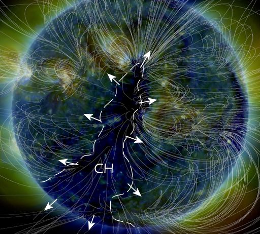
I am hoping the clouds clear soon! Due to an Earth-facing storm on the sun, northern lights may be possible early next week! Here's an excerpt from spaceweather.com: POTENT CORONAL HOLE FACES EARTH: A canyon-shaped hole in the sun's atmosphere is facing Earth, and it is spewing a stream of fast-moving solar wind toward our planet. NASA's Solar Dynamics Observatory photographed the giant fissure on March 25th: This is a "coronal hole" (CH) -- a vast region where the sun's magnetic field opens up and allows solar wind to escape. A gaseous stream flowing from this coronal hole is expected to reach our planet on during the late hours of March 27th and could spark moderately-strong G2-class geomagnetic storms around the poles on March 28th or 29th. We've seen this coronal hole before. In early March, it lashed Earth's magnetic field with a fast-moving stream that sparked several consecutive days of intense auroras around the poles. The coronal hole is potent because it is spewing solar wind threaded with "negative polarity" magnetic fields. Such fields do a good job connecting to Earth's magnetosphere and energizing geomagnetic storms. Arctic sky watchers should be alert for auroras early next week
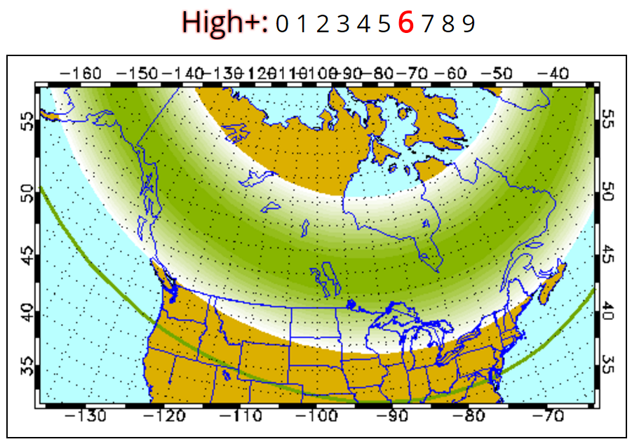
Northern Lights Potential on Tuesday, March 28
According to the Geophysical Institute at the University of Alaska Fairbanks, the northern lights potential for Tuesday, March 28th is HIGH! Stay tuned. Here's their forecast: Weather permitting, highly active auroral displays will be visible overhead from Inuvik, Yellowknife, Rankin and Igaluit to Vancouver, Helena, Minneapolis, Milwaukee, Bay City, Toronto, Montpelier, and Charlottetown, and visible low on the horizon from Salem, Boise, Cheyenne, Lincoln, Indianapolis and Annapolis.
______________________________________________________________________
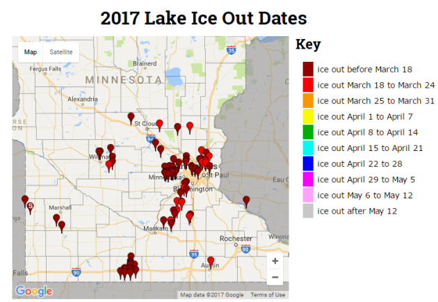
According to the MN DNR, several Minnesota lakes have already gone ice out this year, which is well ahead of normal. Thanks to continued above average this winter and early spring, some lakes have even seen an record early ice out this year!
Active Weather Continues
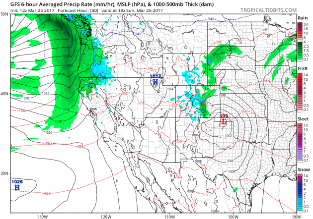
Weather conditions across the country will remain quite active over the next several days as Pacific storms continue to slide across the country. As the storms move east of the Rockies, strong to severe storms will develop with potential of large hail, damaging winds and tornadoes. With several chances of strong to severe storms, locally heavy rainfall will also be possible. Here's the simulated radar through Tuesday, March 29th.
.gif)
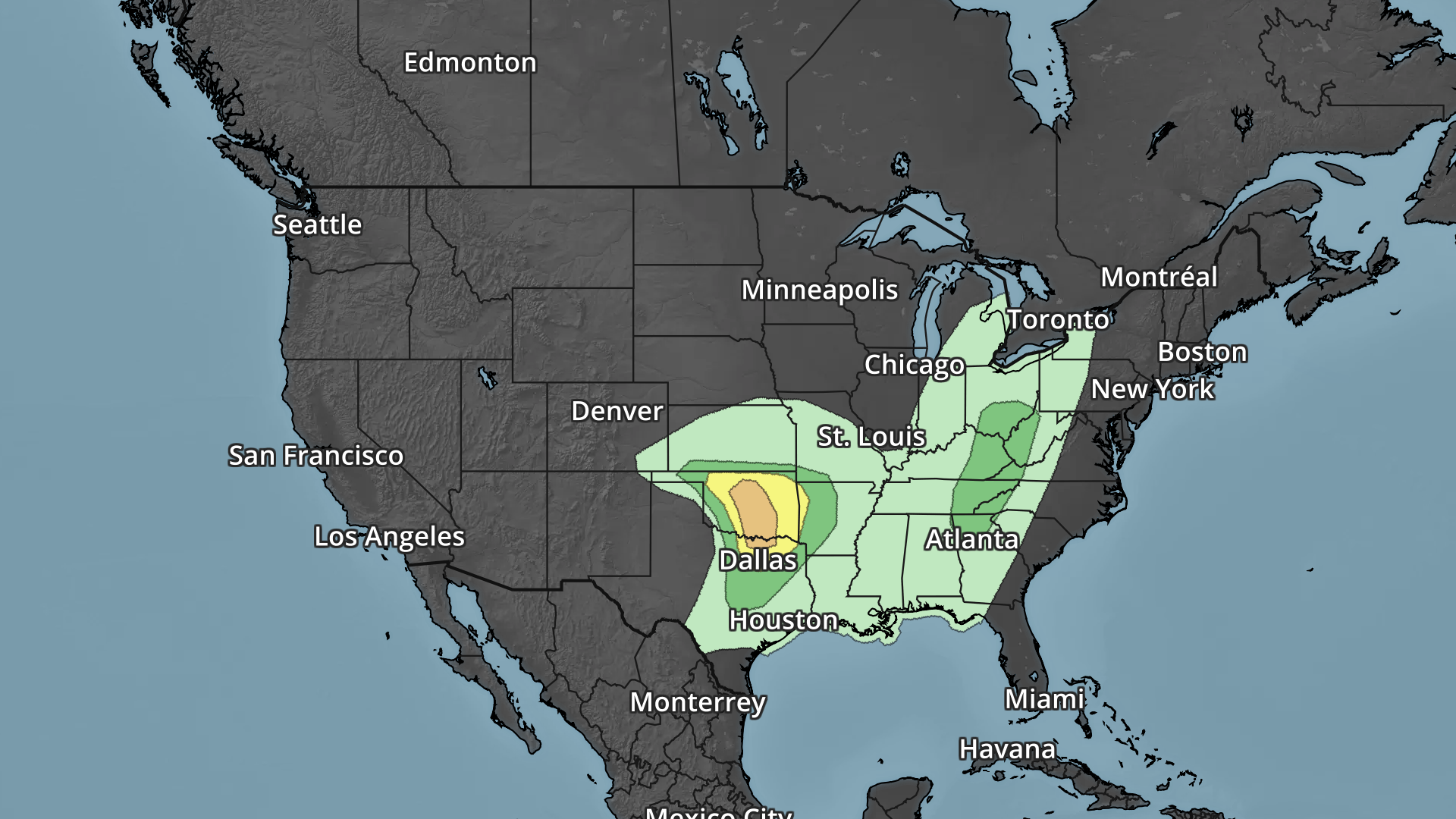
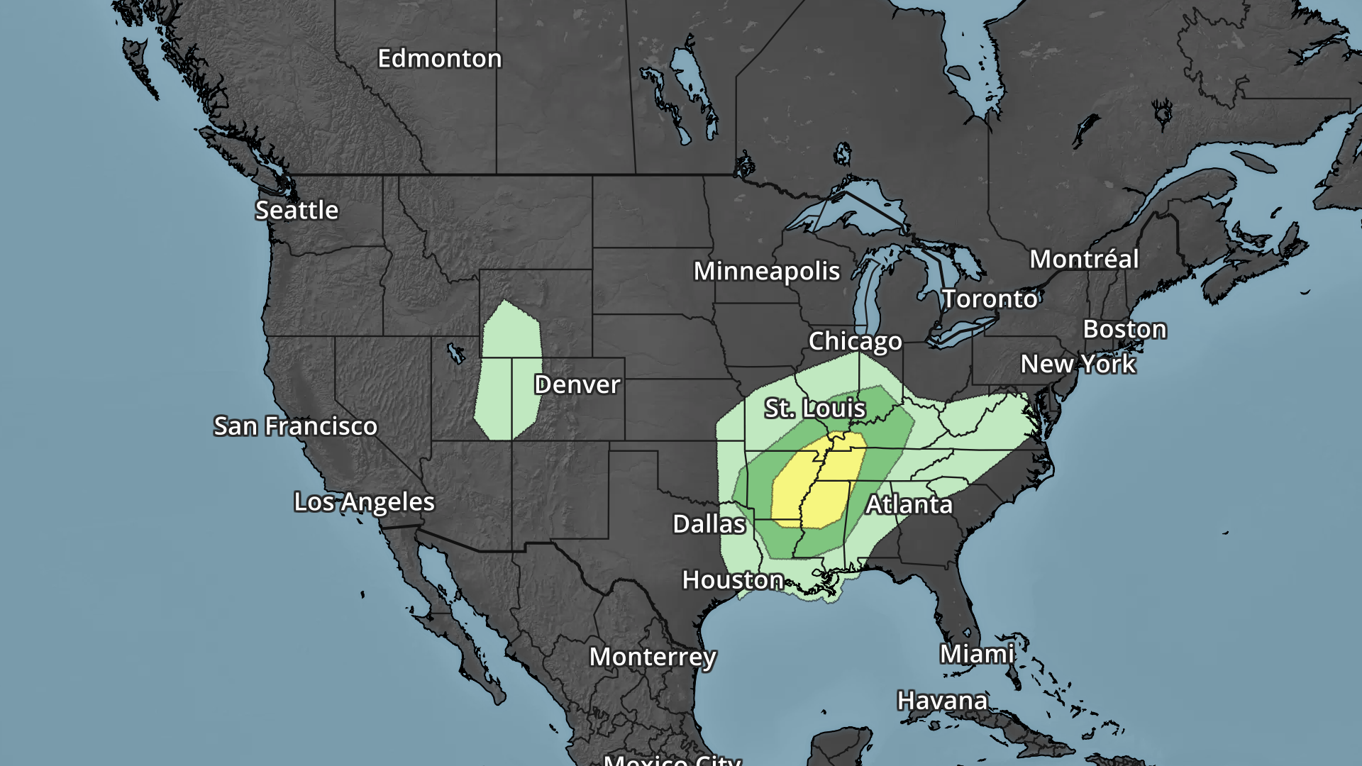
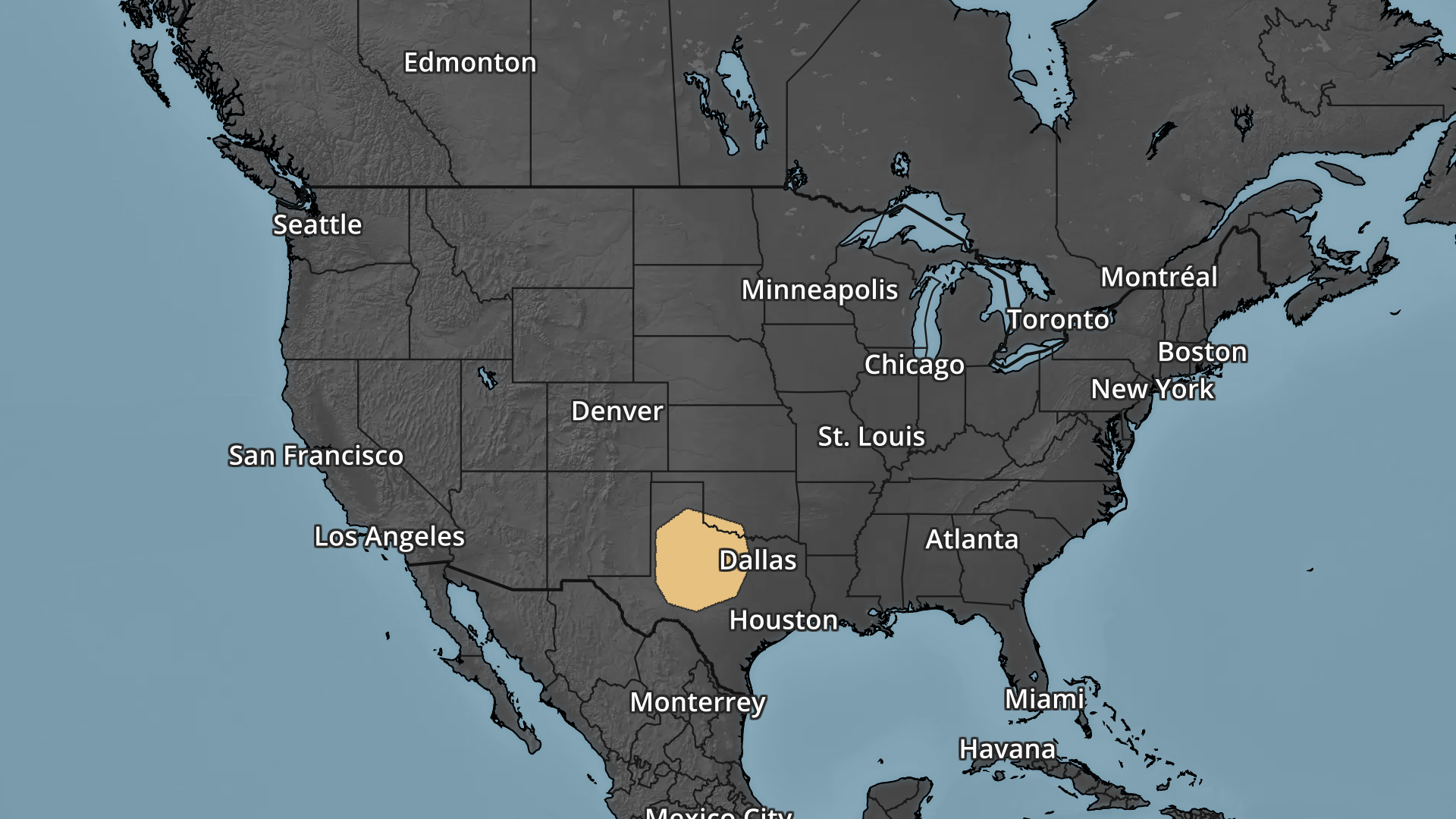
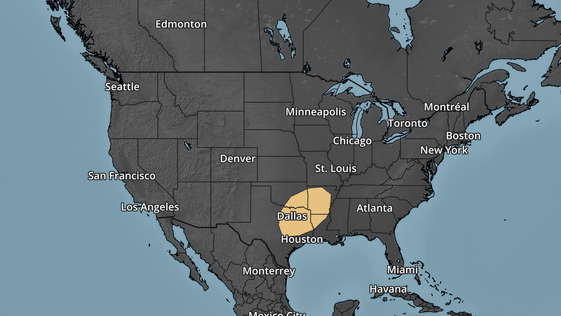
Several Weather Threats Ahead
According to NOAA's SPC, there is a risk of severe weather over the next several days. The images below are the severe threats on Sunday, Monday, Tuesday & Wednesday respectively. Note that large hail, damaging winds and tornadoes will all be possible.
_________________________________________________________________________
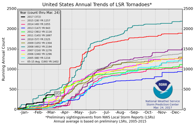
2017 PRELIMINARY Tornado Count
According to NOAA's SPC, the PRELIMINARY tornado count for 2017 is at 372 (thru March 24). Note that this is the most (thru March 24th) since 2012 when nearly 400 tornadoes reported through that time frame. The 2005-2015 average through March 24th is 190.
 ________________________________________________________________
According to NOAA's SPC, there is a risk of severe weather over the next several days. The images below are the severe threats on Sunday, Monday, Tuesday & Wednesday respectively. Note that large hail, damaging winds and tornadoes will all be possible.
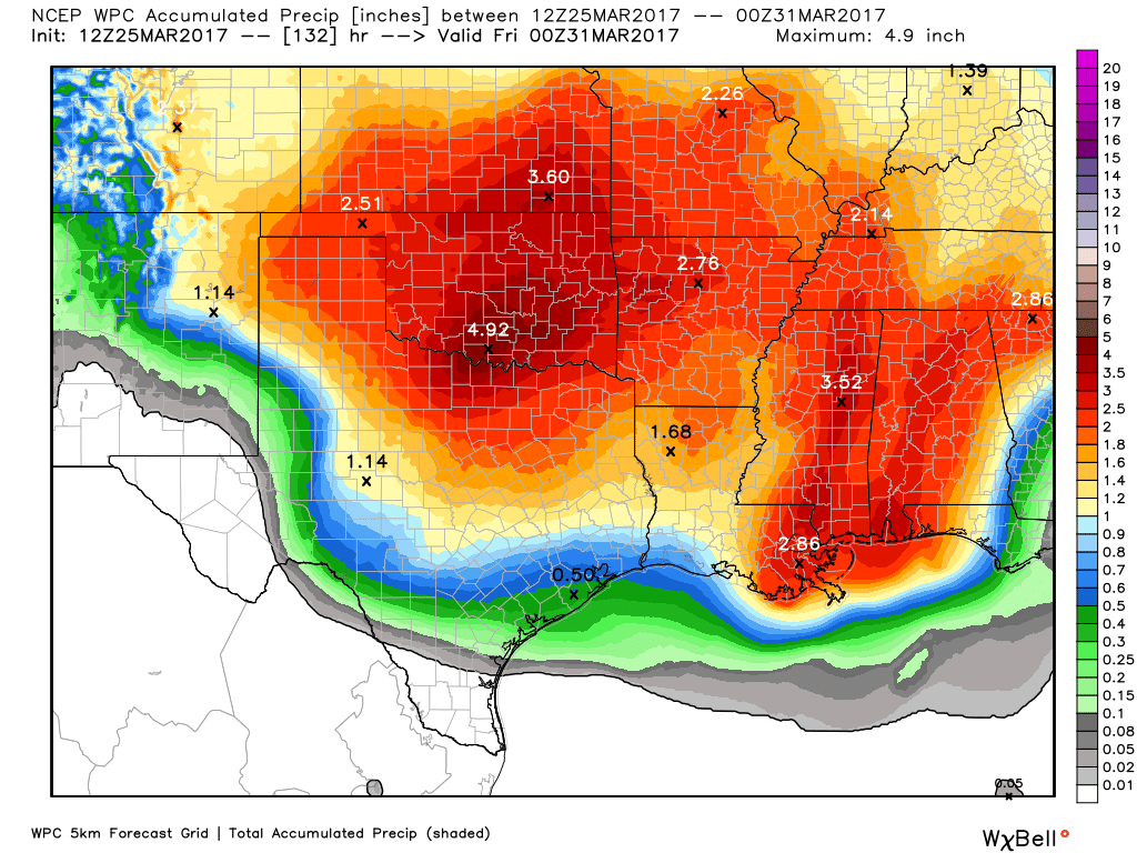
Southern Rainfall Potential
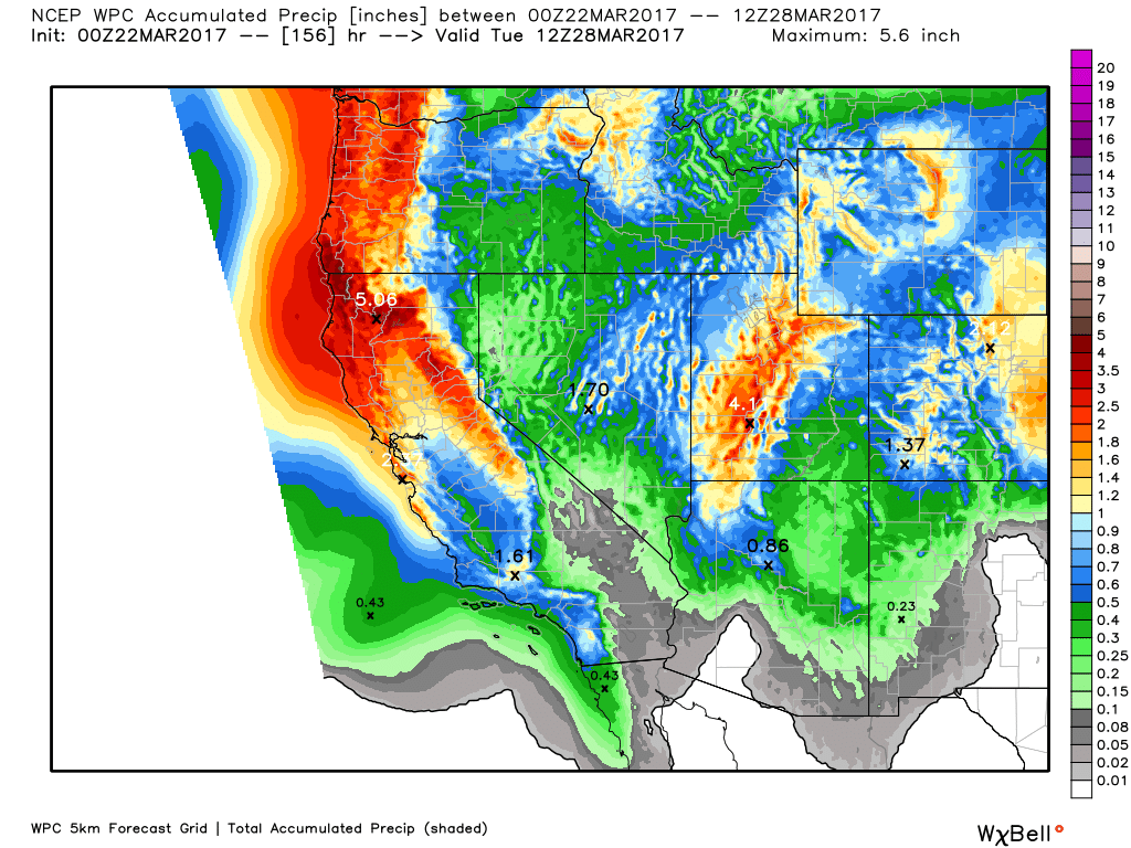
With several days of strong to severe thunderstorms possible over the Central and Southern US, heavy rainfall will be possible as well. Take a look at the precipitation potential through Thursday and note that widespread to 2" to near 4"+ tallies will be possible.
_________________________________________________________________________
2017 PRELIMINARY Tornado Count
According to NOAA's SPC, the PRELIMINARY tornado count for 2017 is at 372 (thru March 24). Note that this is the most (thru March 24th) since 2012 when nearly 400 tornadoes reported through that time frame. The 2005-2015 average through March 24th is 190.
________________________________________________________________
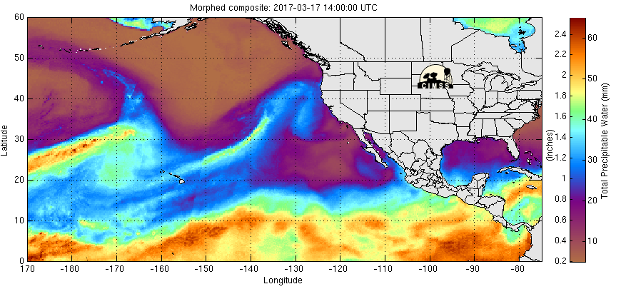
Steady Stream of Pacific Moisture
The precipitable water loop from the Eastern Pacific shows plume of highly concentrated water moving into the West Coast. These streams are and will continue to be responsible for copious amounts of precipitation over the next several days.
Precipitation Continues in the Western US This Week
Here's the weather outlook through the middle part of next week, which shows two waves of heavier moisture moving through the region. Note that there will be a mix of rain and mountain snow as these systems push through.
Here's a look at the precipitation potential through the early next week, which shows as much 4" to 8"+ liquid! There certainly could be areas of flooding with snow melt and as much precipitation as there is expected to be.
____________________________________________________________________________
By Paul Douglas
“Clouds come floating into my life, no longer to carry rain or usher storm, but to add color to my sunset sky” wrote Rabindranath Tagore. Clouds form when air rises and cools, invisible water vapor condensing into microscopic droplets and ice crystals. When they stick together gravity can pull them to the ground as rain or snow. They look light and airy, but a typical puffy cumulus cloud weighs over a million pounds. A towering T-storm keeps BILLIONS of pounds of water and ice suspended overhead! Recently the WMO Cloud Atlas added new varieties of clouds: volutus, wavy asperitus, homogenitus (man-made clouds) and flammagenitus, which form above forest fires.
Knowing cloud type, wind direction & barometric pressure trends and one can make a pretty accurate short-range (6 hour) forecast.
We stare out the window at a smear of stratus clouds Sunday, some thick enough to leak drizzle and light rain showers. Temperatures mellow later this week with a streak of 50s and relatively dry, quiet weather into next weekend as significant storms sail south of Minnesota. Could be worse right?______________________________________________________________________________
Extended Forecast:
SATURDAY NIGHT: Cloudy with a few light showers. Winds: ENE 5-10. Low: 37.
SUNDAY: Persistent clouds. Lingering showers, drizzle. Winds: NE 5-10. High: 45.
SUNDAY NIGHT: Mostly cloudy. A few light spits. Winds: N 5. Low: 36.
MONDAY: More clouds than sun. Better. Winds: N 7-12. High: 52.
TUESDAY: Partly sunny. Spring in your step. Winds: NE 5-10. Wake-up: 38. High: 58.
WEDNESDAY: Clouds increase, showers late. Winds: S 5-10. Wake-up: 41. High: 55.
THURSDAY: Best chance of showers: southern MN. Winds: E 7-12. Wake-up: 42. High: 51.
FRIDAY: Unsettled. Lingering showers. Winds: NE 7-12. Wake-up: 41. High: 50.
SATURDAY: Drying out, peeks of sun. Winds: NW 7-12. Wake-up: 42. High: 56.
_______________________________________________________________________________
_______________________________________________________________________________
This Day in Weather History
March 26th
March 26th
2012: This is the record early ice-out date on Mille Lacs Lake.
2007: Temperature records are shattered across much of central and southern Minnesota and west central Wisconsin. The following records were set: 69 at Alexandria, 75 at Mankato, 77 at Little Falls, 79 at St. Cloud, 81 at Minneapolis-St. Paul and Eau Claire, 82 at Redwood Falls, and 83 at Springfield.
_______________________________________________________________________________
_______________________________________________________________________________
Average High/Low for Minneapolis
March 26th
March 26th
Average High: 47F (Record: 81F set in 2007)
Average: Low: 28F (Record: -10F set in 1996)
Average: Low: 28F (Record: -10F set in 1996)
*Record Snowfall: 8.5" set in 1936
_______________________________________________________________________________
_______________________________________________________________________________
Sunrise Sunset Times For Minneapolis
March 26th
March 26th
Sunrise: 7:04am
Sunset: 7:33pm
Sunset: 7:33pm
*Daylight Gained Since Yesterday: ~3 minutes & 8 seconds
*Daylight Gained Since Winter Solstice (December 21st): ~3 hours & 43 minutes
________________________________________________________________________________
*Daylight Gained Since Winter Solstice (December 21st): ~3 hours & 43 minutes
________________________________________________________________________________
Moon Phase for March 25th at Midnight
1.8 Days Before New Moon
1.8 Days Before New Moon

________________________________________________________________________________
Weather Outlook For Sunday
Sunday will be another cool day across the region with highs warming into the 30s and 40s across the state. However, some spots across the Red River Valley will be near 50F by the afternoon.
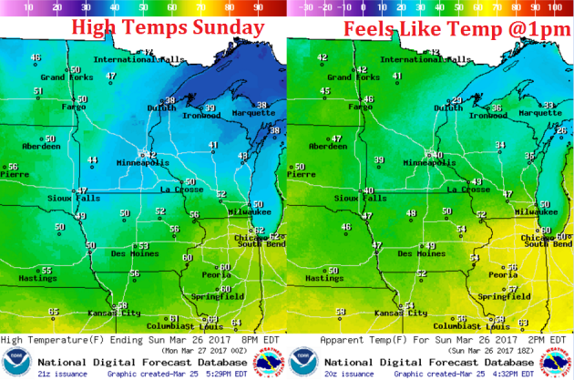
Weather Outlook For Sunday
Winds on Sunday will be fairly light across the region, but with a little breeze out of the north, it'll feel a little cooler than the actual temperature.
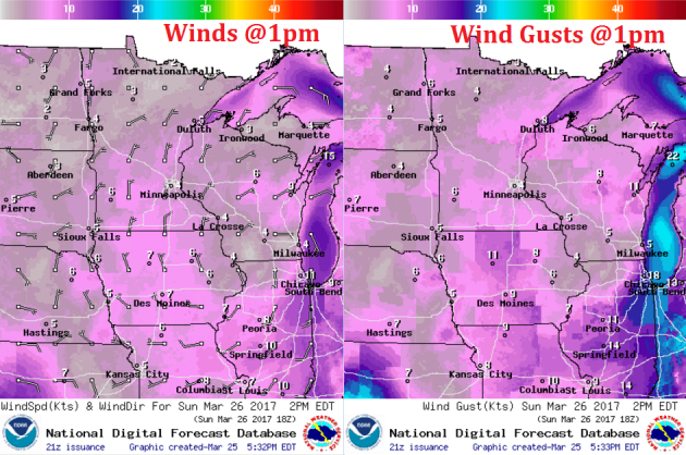
The same storm system that brought parts of the region a few showers earlier this week, will bring us another round of light rain showers on Sunday. Here's the weather potential around midday Sunday, which shows a few showers skirting the eastern part of Minnesota with mostly cloudy skies across the rest of the region.