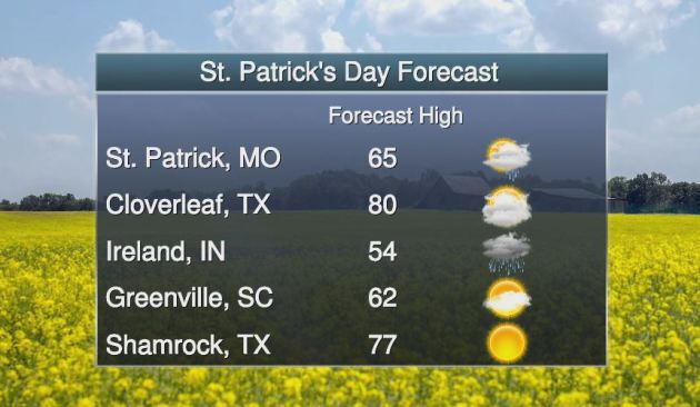
St. Patty's Day Forecast
Happy St. Patty's Day! In the spirit of things, here are a few festive St. Patty's Day city names and the corresponding forecast for Friday, March 17th. Shamrock, TX might be the place to be with mostly sunny skies and highs in the upper 70s! Does that forecast come with a shamrock shake?
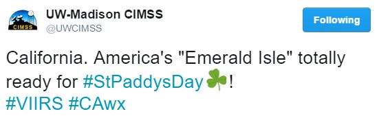
California Ready for St. Patty's Day
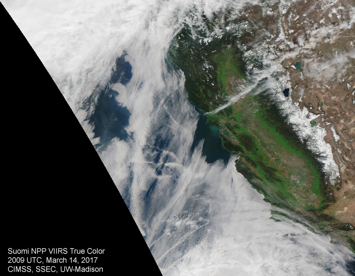
WOW! Look at how green California is right now... This visible satellite image from March 14th showed a brilliant green hue across much of the state thanks to significant quantities of precipitation earlier this year. In some cases, there has been nearly 2ft to 3ft of liquid since the 1st of the year.
California Super Bloom
California is teeming with a brilliant display of wildflower color thanks to very wet early 2017. A Super Bloom developed last weekend and continues now. Here's an excerpt from Wired.com about the "huge bloom that happens maybe once in a decade." THE DESERTS OF southern California erupted in color last weekend as a carpet of purple sand verbena, white dune evening primroses, orange poppies and other wildflowers emerged in a super bloom that one ranger called “flower-geddon.” “This kind of huge bloom happens maybe once a decade,” says Jim Dice, research manager at the Anza-Borrego Desert Research Center who hasn’t seen so spectacular a bloom since 2005. Spring made an exuberant entrance after an unusually wet winter and consistent rainfall through 2016 after a five-year drought. Much of Southern California teems with flowers, but the 630,000-acre Anza-Borrego State Park is alive with color. The nearby community of Borrego Springs more than doubled in size as 5,000 people poured into the area on Saturday, an influx that filled motels, prompted the sheriff to close miles of road, and sparked a fistfight over a pork Cubano. If you can’t make it to SoCal, take out your phone and open Instagram, because it has almost as many photos of the blooms as Anza-Borrego has flowers. Check out #superbloom, #superbloom2017, and #eschscholziacalifornica to get started. And if you go to the desert, you might want to bring your own sandwich.
See more amazing Super Bloom picture from Wired.com HERE:
See more amazing Super Bloom picture from Wired.com HERE:
(Photo Credit: @__Nuggetron__ via Instagram and Wired.com)

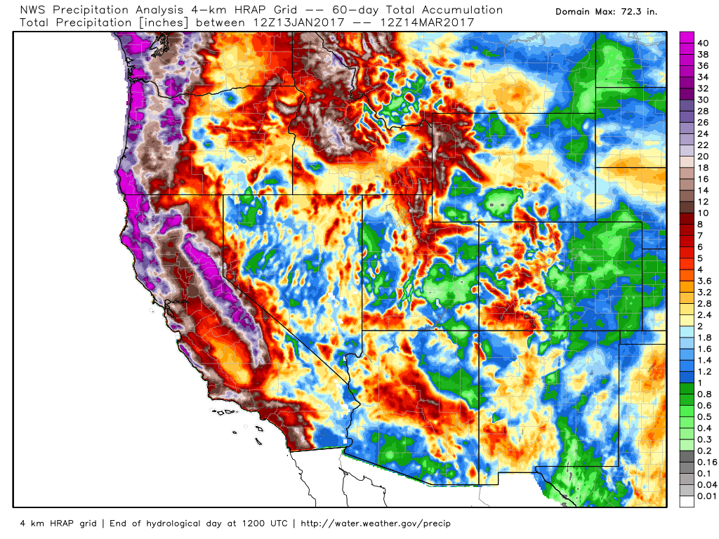
If you're wondering how much precipitation has fallen across the Western US, here's the estimated precipitation over the last 60s days (roughly since mid January 2017). Note that the white and purple colors correlated with nearly 2ft to 3ft+ (liquid) seen in the legend on the right. Pretty impressive!
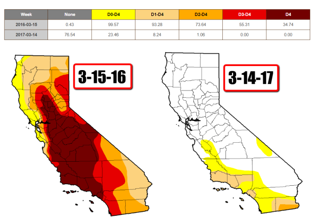
California Drought Comparison 2017 vs 2016
Take a look at the drought comparison from March 15th, 2016 vs March 14th, 2017. Note how much improvement we've seen across much of the state since last year! According to the US Drought Monitor, EXTREME and EXCEPTIONAL drought conditions do not exist anymore and there is only a little sliver of SEVERE drought across the extreme southeastern part of the state! Most of these improvements have occurred since the beginning of 2017!
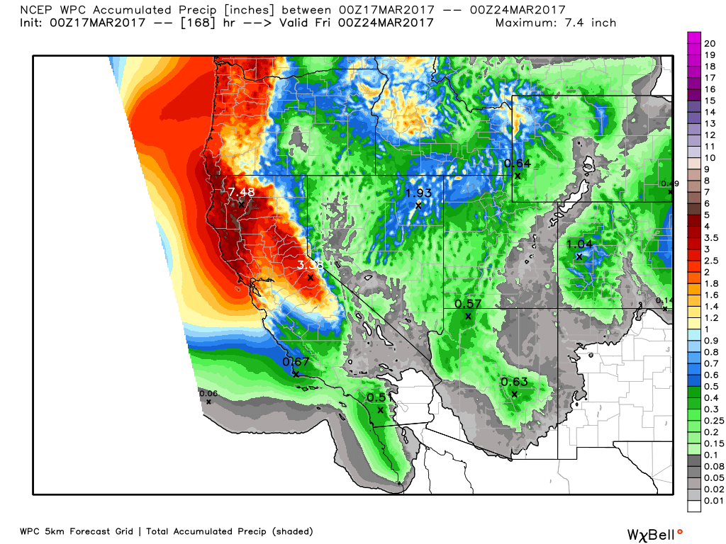
More Rain in California Next Week
Here's the weather outlook from Sunday to Wednesday, which shows another round of precipitation working into the Western US with some fairly decent precipitation tallies. Note that rain will be found in the lower elevations, while areas of heavier snow may be found in the higher elevations.

Western Precipitation Potential
Here's a look at the precipitation potential through Thursday of next week, which shows another round of heavy precipitation moving through the Western US. Some spots could see as much as 3" to 6"+ of liquid.
____________________________________________________________________________
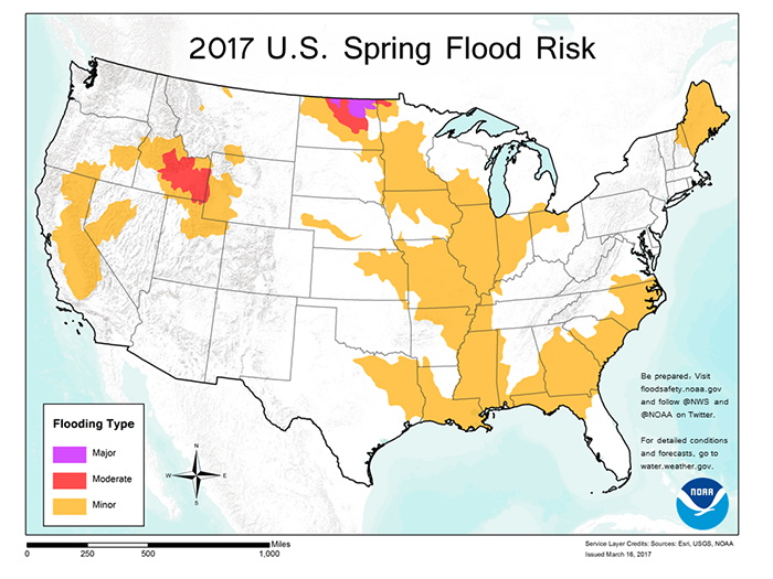
On Thursday, March 16th, NOAA released their 2017 Spring Flood Risk and it showed major flood concerns across parts of North Dakota. Here's an excerpt from NOAA: "Northern North Dakota – the Souris River, Devils Lake and the northernmost reaches of the Red River – has the greatest risk of major flooding this spring, while moderate flooding is possible over southern Idaho in the Snake River basin, according to NOAA’s Spring Outlook released today. California, which saw extensive flooding in February, is susceptible to additional flooding from possible storms through the remainder of the wet season and later, from snowmelt."
See more from NOAA HERE:
____________________________________________________________________________
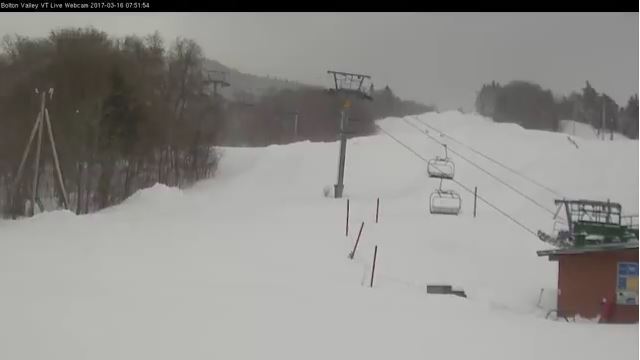
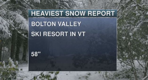
Bolton Valley Ski Resort in Vermont
It is safe to say that the major Northeast snow storm has finally concluded, but folks will still be cleaning up over the next several days. Now that all the numbers are in, the golden snow shovel award goes to Bolton Valley Ski Resort who picked up a whopping 58" - good grief!
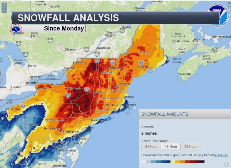
Snowfall Analysis
The map below shows the snowfall analysis from AM Monday to AM Wednesday. Note how widespread the heavy snow was across much of the area. Again, widespread 1ft to 2ft amounts can be seen here with embedded 3ft to near 4ft amounts as well!
More Snow This Weekend?
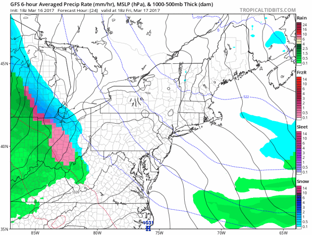
Here's the simulated radar from Friday to Sunday, which shows a another storm system moving into the region. While this storm is nothing like the storm earlier this week, it will still have the capability of bringing some additional snowfall accumulations to parts of the region.
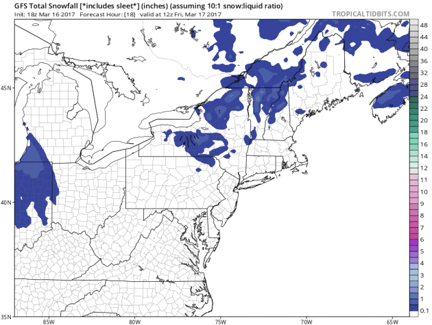
More Snow in the Northeast?
As our next storm system moves into the Northeast, additional snowfall will be possible. While snowfall amounts don't look nearly as heavy as they did earlier this week, some spots could see some shovelable amounts.
___________________________________________________________________________
Cold Temps in the Wake of the Storm...
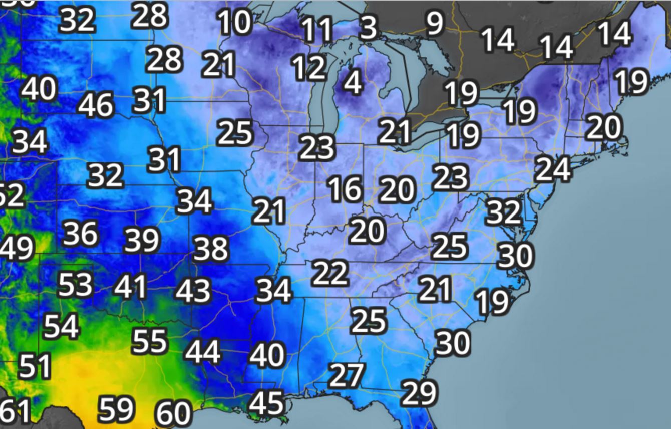
Temperatures in the wake of the storm were very cold across the eastern half of the country. Take a look at how cold it was on Thursday morning and note that temperatures dipped into the upper 20s even across northern Florida!
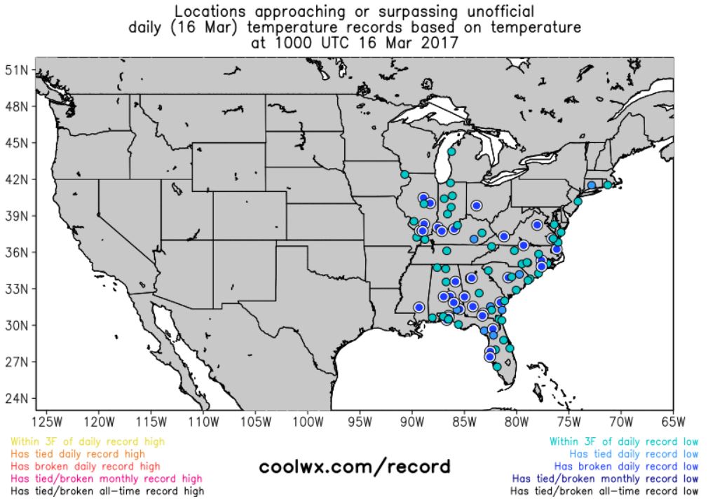
Record Cold Thursday Morning
With temperatures running well below average in the Eastern US for this time of the year, there were several record low temperatures that were set for Thursday, March 16th. Here's a snapshot of a few spots that were either close to a record or had a record.
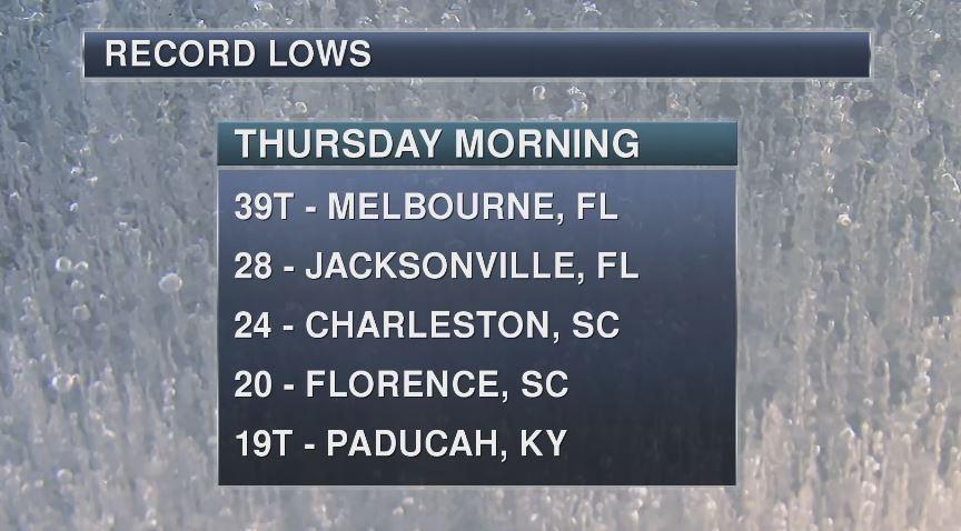
Record Cold Thursday Morning
Here are just a few of the record low temperatures that were tied or set on Thursday morning, March 16th. Note that Jacksonville, FL dipped to 28F!
______________________________________________________________________________
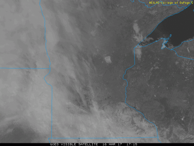
Visible Satellite on Thursday
Here's the visible satellite loop from Thursday, which showed clouds moving into the region. These clouds were associated with some spotty light rain showers PM Thursday.
A Leprechaun Wonders Where Spring Temps Have Gone
By Todd Nelson, filling in for Douglas
By Todd Nelson, filling in for Douglas
Happy St. Patty's Day! Are you feeling lucky? As a kid, I always remember looking for a pot of gold at the end of the rainbow. Now that I know it isn't true, I have resorted to keeping a big bag of skittles nearby.
5 years ago today, warm temps sprouted up across the region and the Twin Cities warmed to a record high of 80 degrees! Although we'll have no chance at record warmth today, we'll at least get back to near normal temperatures. Interestingly, the Twin Cities is running nearly 2 degrees below average through the first half of March. Note that we've had 18 consecutive months with above average temperatures! That's impressive. The last time there was a month with below average temps in the Twin Cities was August 2015.
A fast moving clipper blows through today with wind gusts close to 30mph. Lingering flurries or sprinkles will be possible, while shovelable snow wraps up in the Arrowhead.
Winds will be a nuisance over the next several days, but it'll help the mercury rise into the 50s by Sunday! Feverish, even for Leprechauns
___________________________________________________________________________
___________________________________________________________________________
Extended Forecast:
THURSDAY NIGHT: Mostly cloudy with a few light rain showers. Winds: SE 5-15. Low: 33
FRIDAY: Breezy and mostly cloudy. Lingering sprinkles/flurries, mainly north. Winds: WNW 15-25. High: 45
FRIDAY NIGHT: Mostly cloudy, still breezy. Winds: WNW 15-25. Low: 26.
SATURDAY: Chilly start. Hazy sunshine returns. Winds: NW 5-10. High: 45
SUNDAY: Mild and breezy. Few showers late. Winds: S 10-20. Wake-up: 30. High: 55
MONDAY: Partly sunny and breezy again. Winds: NW 10-20. Wake-up: 33. High: 48
TUESDAY: A little cooler, less wind. Winds: NW 5-15. Wake-up: 25. High: 40.
WEDNESDAY: Clouds thicken. Light mix overnight? Winds: ESE 5-15. Wake-up: 20. High: 39.
THURSDAY: Windy. Rain/snow mix continues. Winds: SE 15-25. Wake-up: 21. High: 40.
_______________________________________________________________________________
_______________________________________________________________________________
This Day in Weather History
March 17th
March 17th
2012: The Twin Cities hits 80 degrees, a new record for St. Patrick's Day and the warmest temperature during the warmest March on record. Amazingly, the high also reached 79 on March 16, 18, and 19 this year.
1965: The Great St. Patrick's Day Blizzard hits northern Minnesota. Two feet of snow dumped at Duluth. 19 inches at Mora.
_______________________________________________________________________________
_______________________________________________________________________________
Average High/Low for Minneapolis
March 17th
March 17th
Average High: 42F (Record: 80F set in 2012)
Average: Low: 25F (Record: -8F set in 1941)
Average: Low: 25F (Record: -8F set in 1941)
*Record Snowfall: 11.2" set in 1965
_______________________________________________________________________________
_______________________________________________________________________________
Sunrise Sunset Times For Minneapolis
March 17th
March 17th
Sunrise: 7:21am
Sunset: 7:22pm
Sunset: 7:22pm
*Daylight Gained Since Yesterday: ~3 minutes & 9 seconds
*Daylight Gained Since Winter Solstice (December 21st): ~3 hours & 14 minutes
________________________________________________________________________________
*Daylight Gained Since Winter Solstice (December 21st): ~3 hours & 14 minutes
________________________________________________________________________________
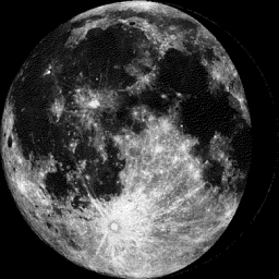
Moon Phase for March 16th at Midnight
3.4 Days Before Last Quarter
3.4 Days Before Last Quarter
________________________________________________________________________________
Weather Outlook For Friday
High temperatures on Friday will be close to average once again across the region with some spots getting back into the 40s. Winds will be a little breezy on Friday, which will make temperatures feel a little cooler than the actual air temp.
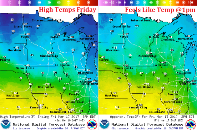
Weather Outlook For Friday
The winds will certainly be quite a bit stronger on Friday. Winds will gust up to 20mph+ as the storm system slides across the international border.
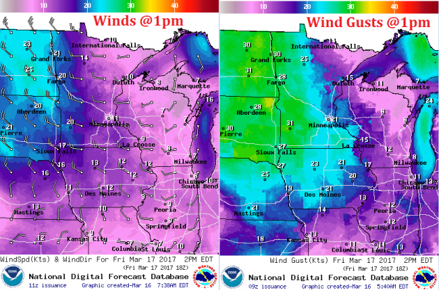
Weather Outlook For Friday
Late Week Clipper
A fast moving clipper system will continue to move through the region on Friday with gusty winds and lingering rain/snow showers, mainly across northern MN.
.gif)
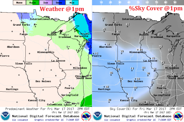
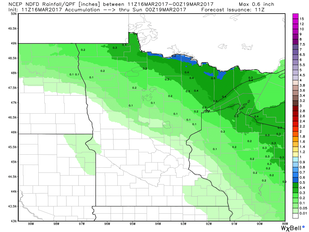
Precipitation Potential Thru Sunday
Our next fast moving clipper system rolls through the region by the end of the week with up to a few tenths of an inch of precipitation across the Arrowhead. Places around the Twin Cities may be lucky to see up to 0.1" liquid through PM Friday
Snowfall Potential
The fast moving storm system may interact with enough cold air to produce a few inches of snow across the Arrowhead over the next few days. In fact, some of this snow could be shovelable!
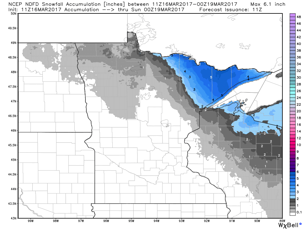
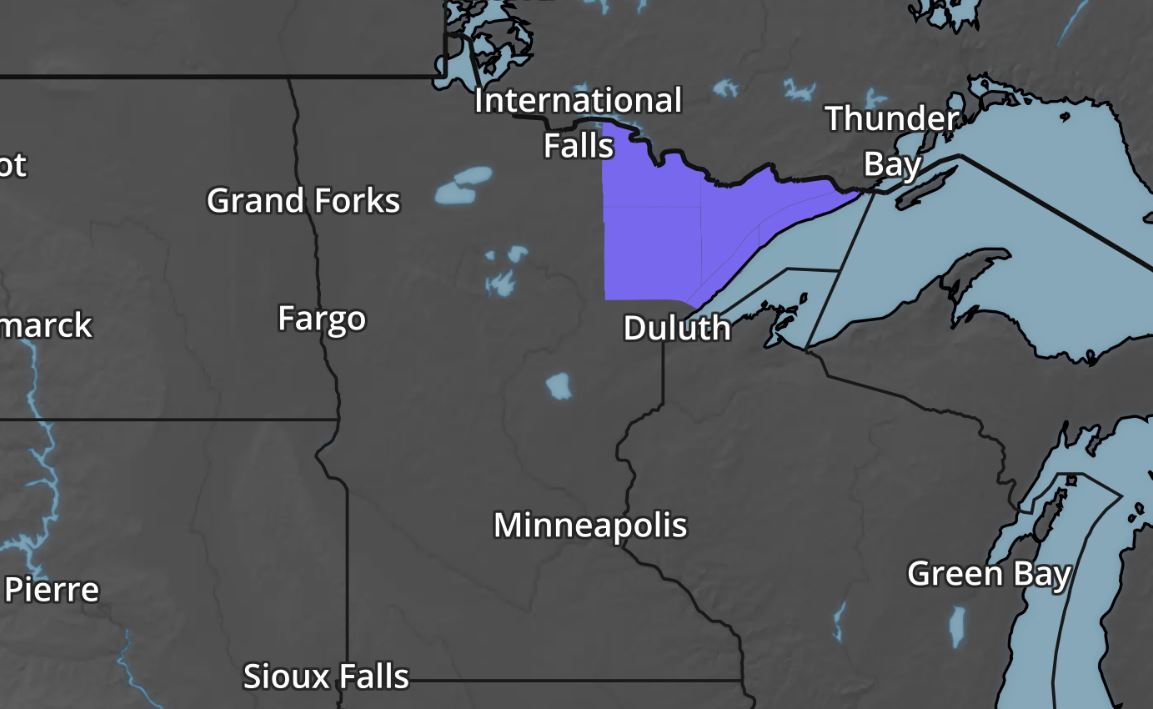
Winter Weather Advisory
The National Weather Service in Duluth, MN has issued a Winter Weather Advisory from PM Thursday to AM Friday for snowfall amounts that could reach shovelable levels. As much as 3" to 5" of snow can't be ruled out across the Arrowhead.
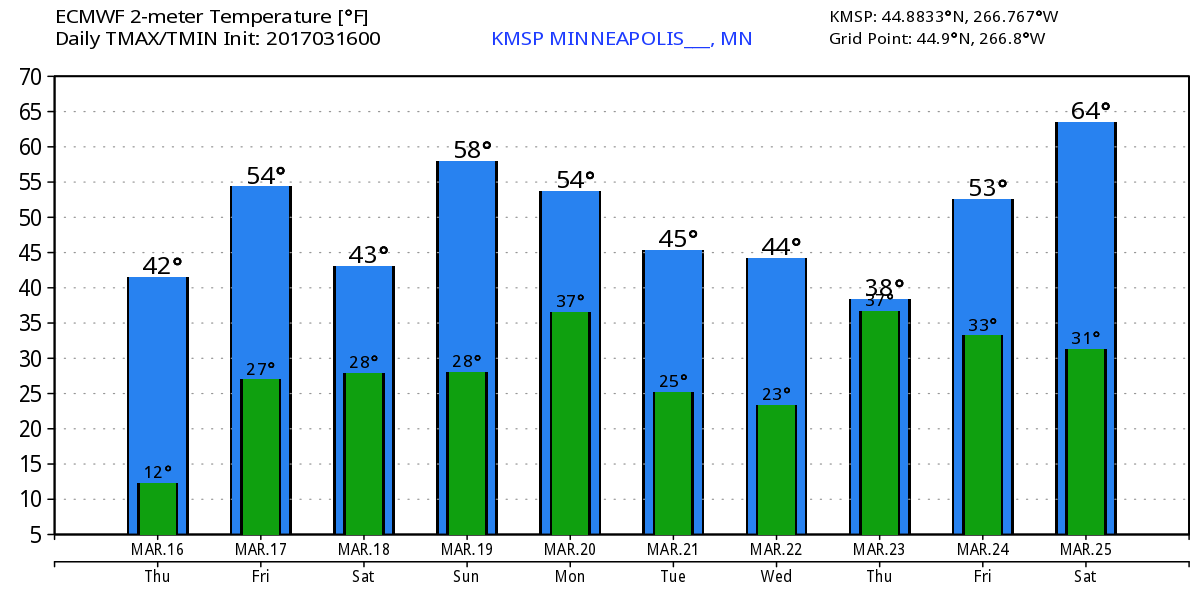
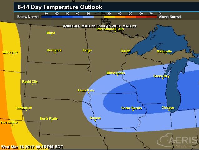
Extended Temperature Outlook for Minneapolis
Here's the temperature outlook through March 25th, which shows gradually warming temperatures through the end of the week with a few chances of hitting 50F around the weekend. The extended forecast shows readings falling back into the 30s late next week.
______________________________________________________________________________
______________________________________________________________________________
According to NOAA's CPC, the 8 to 14 day temperature outlook suggests cooler than average temperatures moving in across parts of the Upper Midwest/Great Lakes from March 25th - 29th. Note that the average high in the Twin Cities through the last week of March is typically in the mid to upper 40s, so we may be a little cooler than that by the end of the month... Stay tuned.
_________________________________________________________________________________
Temperature Outlook
 ________________________________________________________________________________
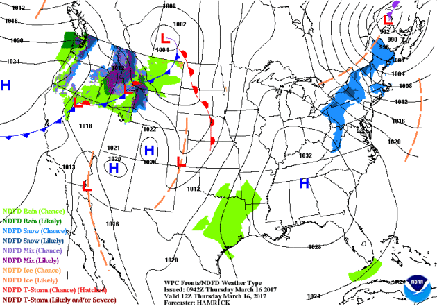
National Weather Outlook
Here's the national weather outlook through the end of the week, which shows the major Northeast storm fading on Thursday, while a system pushes through the Pacific Northwest and into the Midwest later this week. Meanwhile. Eventually this system will move into the Northeast with another round of rain/snow.
_____________________________________________________________________
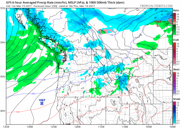
Waves of Pacific Moisture in the Northwest
More rounds of heavier Pacific moisture will continue to push into the Northwest over the next few days with heavier rain along the coast and some mountain snow.
Precipitation in the Northwest
The precipitation potential through PM Tuesday suggests that another 2" to 4"+ liquid may be possible across the region. Note that some of the heavier tallies look to be along the coast and in the higher elevations. Flood concerns may come into play here as snow melt and rainfall ramps up.
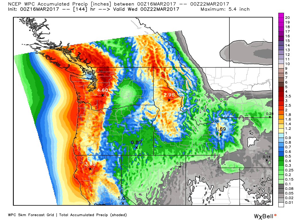
5 Day Precipitation Forecast
According to NOAA's WPC, the 5 day precipitation forecast suggests widespread 3" to 6"+ precipitation amounts across parts of the Pacific Northwest. Meanwhile, heavy precipitation will wrap up in the Northeast through the midweek time frame with another surge of moisture moving in late week and weekend ahead.

_____________________________________________________________________________
_____________________________________________________________________________
Here's the snowfall potential through the end of next weekend, which shows heavy snow finally wrapping up in the Northeast, but another round of snow looks to move through parts of the Great Lakes and into the Northeast by late week and weekend ahead.
________________________________________________________________________

_____________________________________________________________________
"Climate change is making us sick, top U.S. doctors say"
"From increases in deadly diseases to choking air pollution and onslaughts of violent weather, man-made climate change is making Americans sicker, according to a report released Wednesday by 11 of
the nation's top medical societies. The report was prepared by the" Medical Society Consortium on Climate and Health, a new group that represents more than 400,000 doctors, who make up more than half of all U.S. physicians."
the nation's top medical societies. The report was prepared by the" Medical Society Consortium on Climate and Health, a new group that represents more than 400,000 doctors, who make up more than half of all U.S. physicians."
___________________________________________________________________________
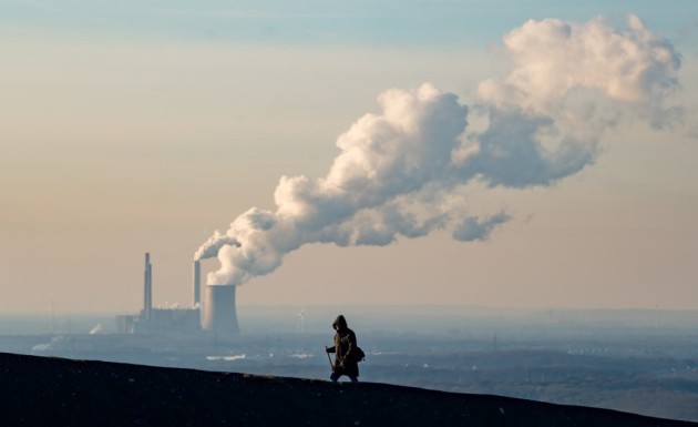
"Don’t look now, but reality is winning the climate debate"
Many of the estimates of the long-term effects of climate change focus on outcomes that will be obvious by the year 2100. Climate change isn’t weather change, and the slow warming of the Earth is best measured by changes over decades, not days. That’s been inconvenient for those hoping to draw attention to the issue in an age when attention spans are fleeting and debates are often resolved when one side points to some anecdote as definitive — for example, when a member of the Senate thinks a February snowball somehow rebuts the idea there’s a long-term warming trend. There are visible effects: rising sea levels, increased precipitation bursts and, of course, the three-year streak of hottest years ever. But one can’t simply point to one thing that happens and say, “That. That’s climate change.” For those disinterested in accepting the scientific consensus on the subject, that’s helpful. A concerted political effort about a decade ago leveraged the public’s uncertainty and our rhetorical habits to effectively blunt policies that would have addressed the issue. That built climate change into a central partisan litmus test. But now, as President Trump figures out how to roll back his predecessor’s efforts on climate policy, something interesting has happened: Gallup polling suggests that Americans have broadly accepted the science — and risks — of global warming.
(Steam and exhaust rise from the power plant of STEAG on Jan. 6, in Oberhausen, Germany. (Lukas Schulze/Getty Images)
________________________________________________________________________
"Health And Climate Change: An Urgent Need For Action"
"The human face of climate change is its impact on our health. Higher temperatures intensify air pollution and respiratory illness. Changing weather patterns lead to drought and then famine, while increasing rains in other areas will create the breeding ground for disease and pandemics. While the policy changes needed to blunt climate change are surely substantial, the cost of ignoring the science behind climate change will be felt through its harmful effects on our health. Recently, the CDC canceled its Climate and Health Summit out of fear of retribution from the Trump administration. Working with Al Gore and others, Harvard worked to revive the meeting, which was held in Atlanta on February 16. This meeting reminded us that universities have a unique responsibility that we ensure a platform for key scientific issues that have a meaningful effect on people’s health. Climate change is one such critical issue."
(BRAZIL PHOTOS VIA GETTY IMAGES and HuffingtonPost.com)
_____________________________________________________________________________
Thanks for checking in and don't forget to follow me on Twitter @TNelsonWX

No comments:
Post a Comment