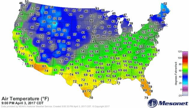
50 F. average high on April 4.
42 F. high temperature on April 4, 2016.
April 5, 1999: Heavy snow falls over the Arrowhead, with 11 inches at Two Harbors.
April 5, 1929: A tornado cuts a path from Lake Minnetonka through North Minneapolis and leaves six dead.
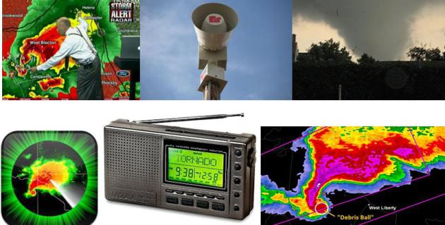
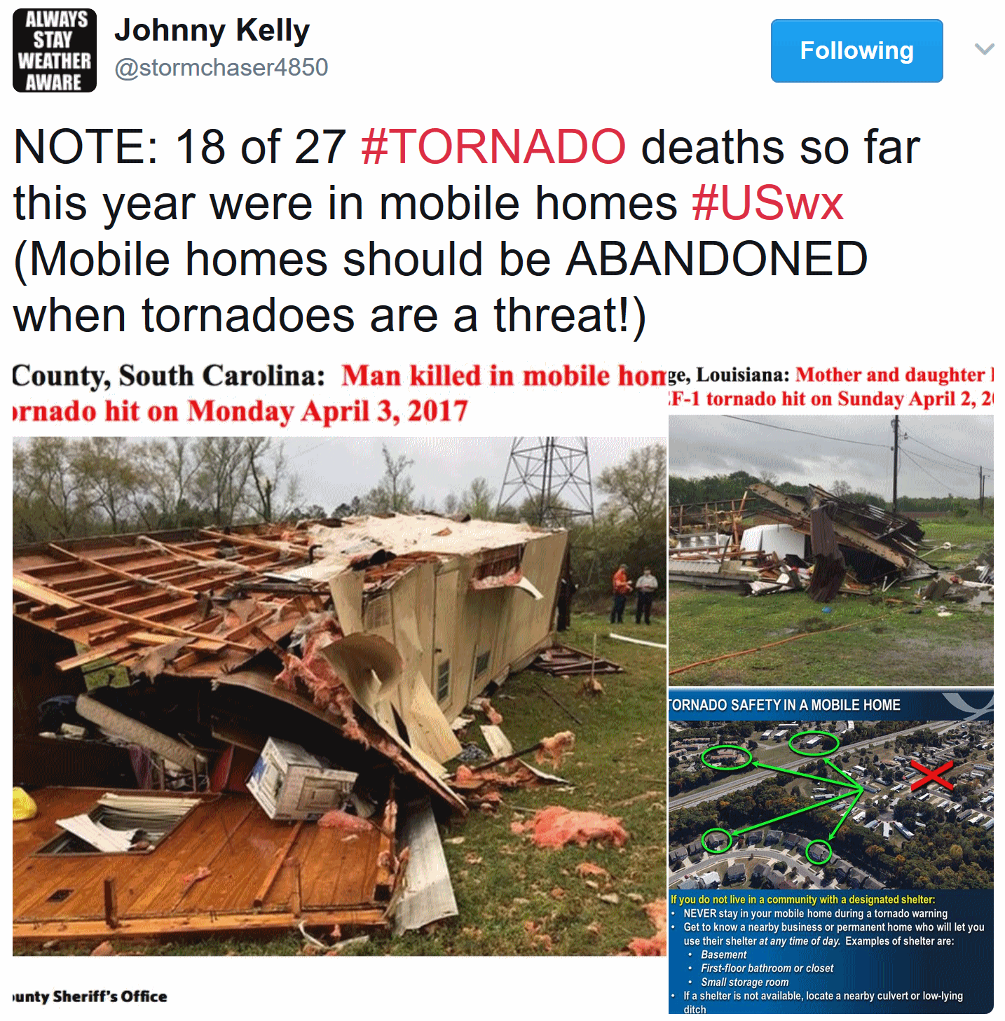
This Year Don't Rely Just on Emergency Sirens
It's 2017, and still no flying cars. Most of us are walking around with little supercomputers in our pockets & purses. And smartphone apps are an effective way to get not only GPS-specific weather, but time-sensitive warnings. My favorites are Aeris Pulse (full disclosure: my company cooked this one up) and RadarScope.
It's 2017, and still no flying cars. Most of us are walking around with little supercomputers in our pockets & purses. And smartphone apps are an effective way to get not only GPS-specific weather, but time-sensitive warnings. My favorites are Aeris Pulse (full disclosure: my company cooked this one up) and RadarScope.
Research
confirms the more sources of weather information, the greater the odds
you'll get a warning in time to take evasive action. Radio, TV, NOAA
Weather Radio and sirens are all part of a well-rounded weather diet.
Sirens
are cold war technology, designed to be heard outdoors only. If you
only rely on sirens to take action you're going to get caught with your
Doppler down.
April
brings greening lawns, budding flowers and trees - and more frequent
severe outbreaks, but the atmosphere overhead will be too cool and
stable for hail or tornadoes this week.
Tornadoes strafe the Southeast today; a soaking rain triggers flooding
in the Northeast tomorrow. Here? Dry into Saturday, when temperatures
may hit 70F. T-storms Sunday could be strong to severe. Here we go!
The United States of Extremes.
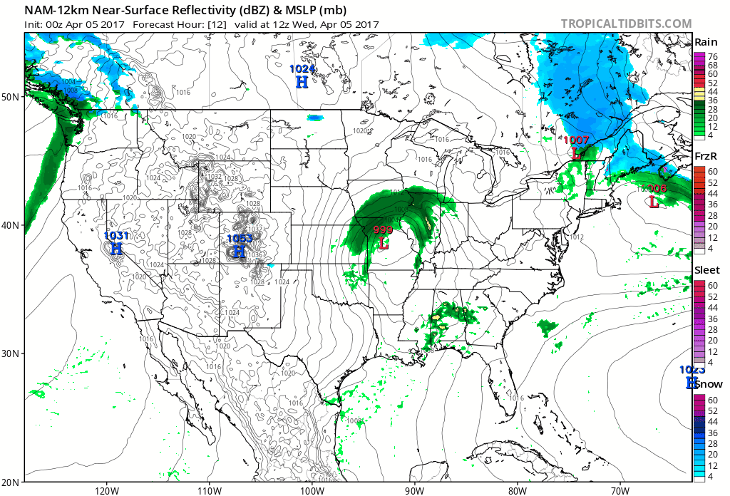
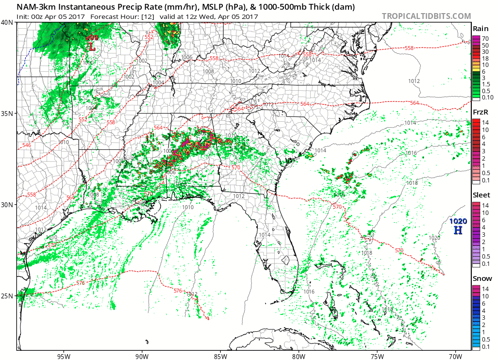
Today's storm spawns tornado-producing supercell thunderstorms across
the Southeast, while a shield of heavy rain changes to heavy wet snow
across the Great Lakes and Ohio Valley. Meanwhile (no surprise) another
sloppy front invades the Pacific Northwest. A super-sized severe weather
spring is brewing - just a continuation of trends present in the
pattern since January. 84-hour NAM Future Radar: NOAA and
Tropicaltidbits.com.
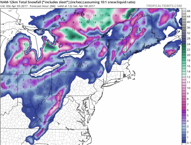
April Lake Effect.
What little ice formed on the Great Lakes this past "winter" is pretty
much gone; a moist fetch off the water enhancing snowfall rates
downwind. Plowable snow amounts are possible over Lower Michigan, maybe a
couple inches for the Ohio Valley, where much of the slush will melt on
contact.
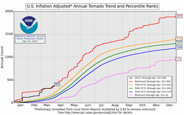
2017 Off to Record-Breaking Start for Tornadoes and Severe Weather. Will It Continue? At the rate we're going 2017 may set more tornado records. Here's an excerpt from U.S. Tornadoes: "2017
has been off to as fast a start to the severe weather season as any in
the modern record. Through the beginning of April, it’s running
neck-and-neck with 2008 for first place. There have been outbreaks in
each month of the year, and roughly 360 to 400 tornadoes so far. That’s
more than twice normal to date, and we’ve barely even started to wander
through the beginning of peak severe weather season, which runs
April-June. The country is also in the midst of a two-week long
onslaught of severe storms, with more on the way over the next few days..."
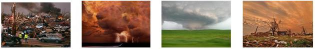
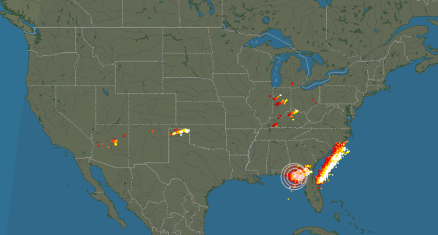
- An active severe weather day is expected from the Ohio Valley to the Southeast on Wednesday. A Moderate Risk of severe weather is in place for tomorrow across parts of the Southeast, including metro Atlanta.
- The main risks across this area include tornadoes (some of which could be strong and long-tracked), damaging winds and large hail. These conditions will also be possible across the Enhanced Risk area, which stretches as far north as southern Indiana and Ohio.


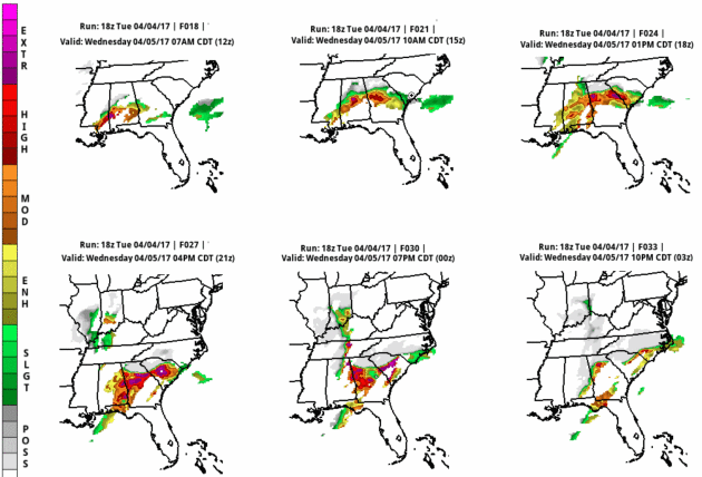
Summary. A severe weather outbreak is expected Wednesday across parts of the Southeast north into the Ohio Valley, with tornadoes (some potentially strong and long-tracked), large hail and damaging winds possible. A Moderate Risk of severe weather is in place for portions of Florida, Alabama, Georgia and South Carolina Wednesday, including the cities of Atlanta, Columbus and Macon (GA), as well as Montgomery (AL). It is over this area that has the highest potential of seeing strong tornadoes, particularly during the afternoon and evening hours. Today would be the day to make sure facilities across the severe threat area are up to date on severe weather procedures as tomorrow is likely to be active.
D.J. Kayser, Meteorologist, Praedictix
Ripe for Supercellular T-storms. Watch the isolated cells out ahead of the main squall line later today. These are the storm most likely to start spinning in response to very strong wind shear. Conditions are ripe for a major outbreak of tornadoes, and city centers from Montgomery and Auburn to Atlanta, Macon and Columbia may see severe weather and violent winds. 3 KM NAM: Tropicaltidbits.com.
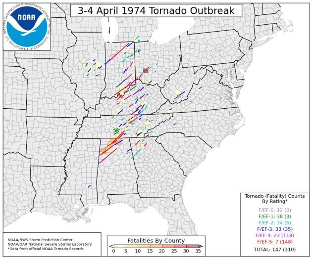
How 148 Tornadoes In One Day in 1974 Changed Emergency Preparedness. Smithsonian Magazine provides perspective: "...But
two important things happened because of the 1974 outbreak, research
meteorologist Howard Brooks told Galvin. “First, the National Weather
Service adopted the Fujita Scale. And second, support and money for
tornado-intercept operations greatly increased.”
The Fujita scale created a standard language for the scientific
community to talk about tornadoes, Galvin writes. Intercept operations,
which send scientists out to actually chase tornadoes, have allowed them
to observe what was happening firsthand, improving future warnings.
These innovations, combined with the money and political will to update
detection gear, mean that the National Weather Service now has more
weather stations and better forecasting technology, he writes. Research,
more weather stations, and Doppler radar combined have increased the
average tornado warning time from "about zero," as one meteorologist put
it, to 12 to 14 minutes. "It doesn't seem like a lot," he told Galvin,
"but when you need to take shelter every minute counts..." (Map credit: NOAA).
 70-ish This Weekend.
Saturday looks like the nicer, drier, sunnier day with a good shot at
70F if the sun stays out most of the afternoon. ECMWF guidance hints at a
few showers and T-storms Sunday, marking the leading edge of a cooler
front early next week. MSP numbers: WeatherBell.
70-ish This Weekend.
Saturday looks like the nicer, drier, sunnier day with a good shot at
70F if the sun stays out most of the afternoon. ECMWF guidance hints at a
few showers and T-storms Sunday, marking the leading edge of a cooler
front early next week. MSP numbers: WeatherBell.
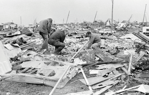
Xenia (Ohio) Tornado Anniversary.
The Super Outbreak of April 3, 1974 was staggering in scope and
intensity; one of the reasons I ultimately became a meteorologist. The Xenia Gazette remembers that terrible day: "The
tornado injured 1,150 and destroyed approximately 1,400 buildings —
about half of those in Xenia. Nine schools, nine churches and almost 180
businesses were destroyed in the F5 tornado, which claimed more than 30
lives. The twister was part of the the 1974 Super Outbreak, which was
the second-largest tornado outbreak on record for a single 24-hour
period, just behind the 2011 Super Outbreak. It was also the most
violent tornado outbreak ever recorded, with 30 F4/F5 tornadoes
confirmed. From April 3 to April 4, 1974, there were 148 tornadoes
confirmed in 13 U.S. states and Ontario, Canada. Tornadoes struck
Illinois, Indiana, Michigan, Ohio, Kentucky, Tennessee, Alabama,
Mississippi, Georgia, North Carolina, Virginia, West Virginia and New
York. The entire outbreak caused more than $600 million (in 1974
dollars) in damage in the U.S. alone, and extensively damaged
approximately 900 square miles along a total combined path length of
2,600 miles according to online reports. At one point, as many as 15
separate tornadoes were ongoing at the same time..."
Photo credit: "Monday
was the 43rd anniversary of the 1974 Xenia tornado. The days and months
after April 3, 1974, tornado were filled with many scenes like the ones
you see here. The tornado injured 1,150 and destroyed some 1,400
buildings — about half of those in Xenia. Nine schools, nine churches
and almost 180 businesses were destroyed in the F5 tornado."
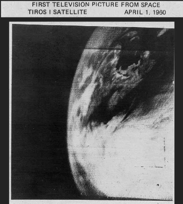
Celebrating the World's First Meteorological Satellite: TIROS-1. NOAA NESDIS
has a good write-up on the first weather satellite, an event that
changed our capabilities - and expectations here on the ground: "...TIROS-1
orbited 450 miles above Earth and communicated with two command and
data acquisition stations. When the satellite was in range of a station
and the data was read out, the images (up to 32 could be recorded for
playback) were recorded on 35-mm film for making prints. Although the
satellite operated for only 78 days, TIROS-1 sent back 19,389 usable
pictures, proving the worth of weather observing satellites to the world
and opening the door for the weather systems of the future. The first
image from the satellite was a fuzzy picture of thick bands and clusters
of clouds over the United States. An image captured a few days later
revealed a typhoon about a 1,000 miles east of Australia..."
Image credit: "One of the first images from the TIROS-1 satellite, April 1, 1960." Credit: NASA
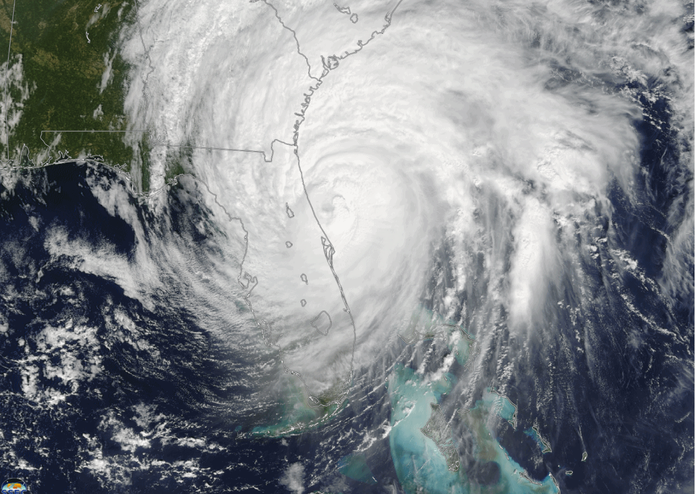
Tropical Cyclone Report on Hurricane Matthew. Check out the 96 page (PDF) from NOAA on last year's biggest hurricane to threaten the southeastern USA. (Hurricane Matthew file: University of Wisconsin SSEC).
Senate Passes Comprehensive Bipartisan Bill to Improve Weather Forecasting. An encouraging step in the right direction; details via Jason Samenow at Capital Weather Gang: "After stumbling
blocks and delays, sweeping bipartisan legislation to improve weather
forecasting has passed the Senate. The 65-page bill, the Weather
Research and Forecasting Innovation Act of 2017, H.R. 353, contains four
sections that support research and programs to improve weather
forecasting and its communication on short and long time scales.
Containing scores of provisions, the bill would require the National
Oceanic and Atmospheric Administration to, for example:
- Establish a program to improve tornado warnings.
- Protect the Hurricane Forecast Improvement Program, whose funding was previously slashed.
- Develop a formal plan for weather research.
- Develop an annual report on the state of its weather models..."
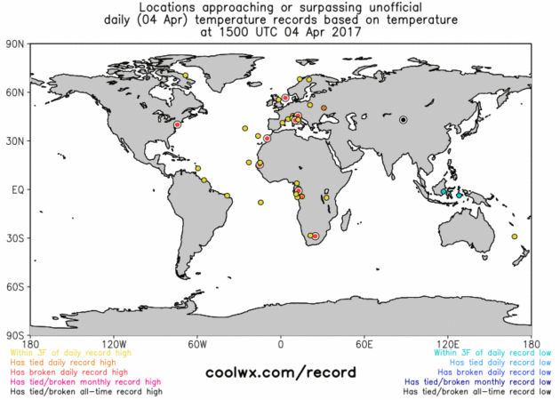
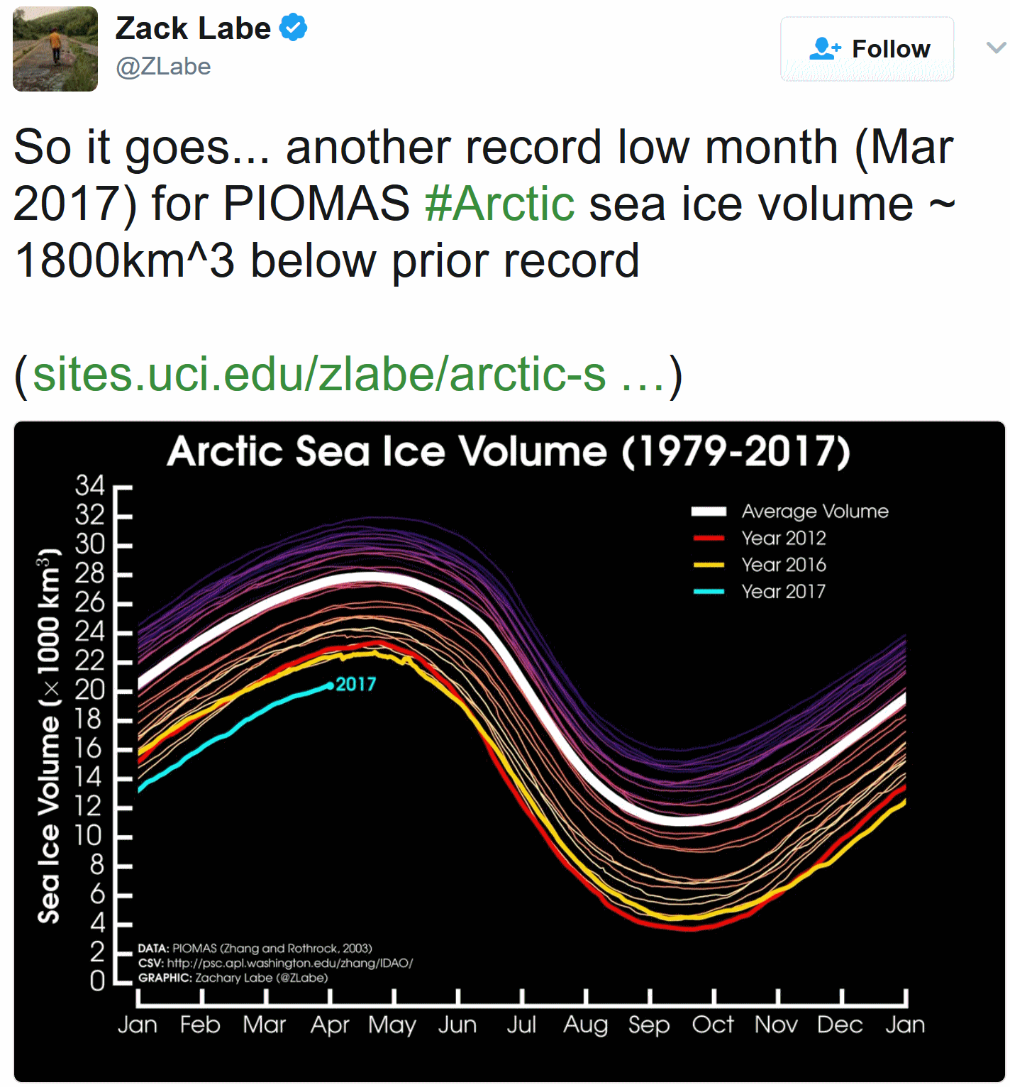
Global Temperature Records. Coolwx.com
still has the best site (in my humble opinion) when it comes to
tracking U.S. and global temperatures that are close to record
territory.
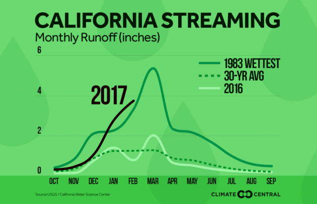
Graphic credit: "More water is flowing this year in California from frequent storms and melting snowpack." Credit: Climate Central
Wealth Didn't Matter. Pollution From a Coal-Fired Plant, Carried Miles by Wind, Still Hurt Their Babies. One of many reasons why we probably don't want to go back to a "coal-first" energy diet. Here's an excerpt from The Washington Post: "Air
pollution from power plants has wanderlust. It never stays still. It
rides the wind, drifting far from its source, visiting homes miles away
with potentially harmful effects. New research released Monday documents
the impact that pollution from a coal-fired plant in Pennsylvania had
on four wealthy New Jersey counties as far as 30 miles downwind. Women
in those counties had a greater risk of having babies of low or very
low birthweight — less than 5½ pounds — than did women in similarly
affluent areas. It didn’t matter that the mothers there had
advantages that low-income mothers don’t: money and access to private
health care. Their babies still appeared to suffer from the effects of
air pollution, specifically wind-borne sulfur emissions. The study
authors say stronger federal regulation of emissions from coal-fired
plants is needed to safeguard human health..."
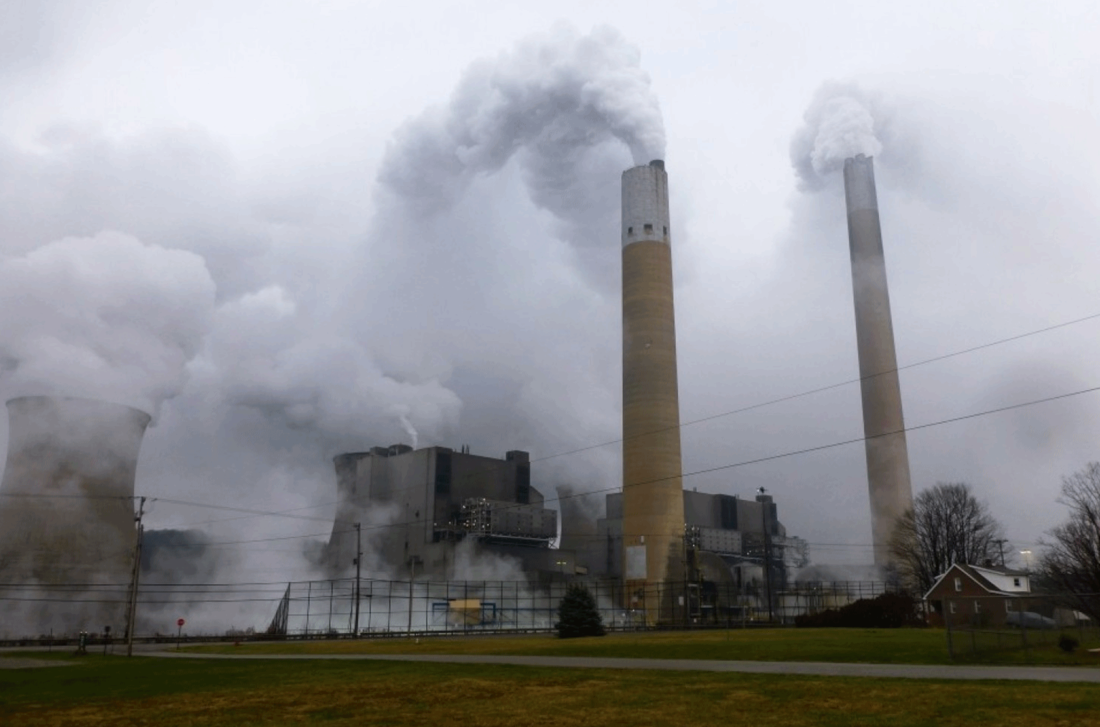
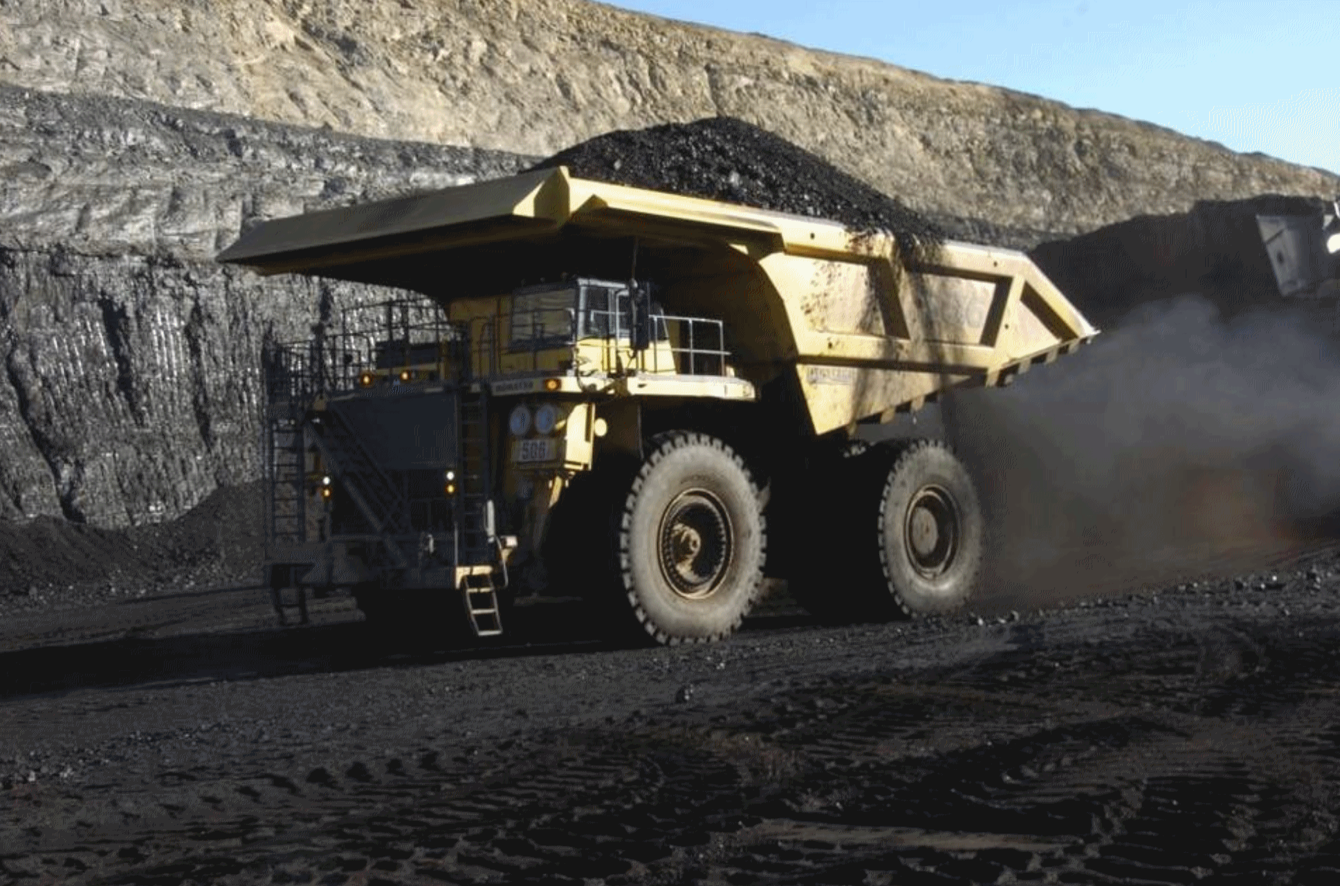
Photo credit: "Smoke
and steam billow from cooling towers and smokestacks at the Bruce
Mansfield power plant near Shippingport, Pa., one of the country’s
largest coal-fired power generators." (Joby Warrick/The Washington Post).
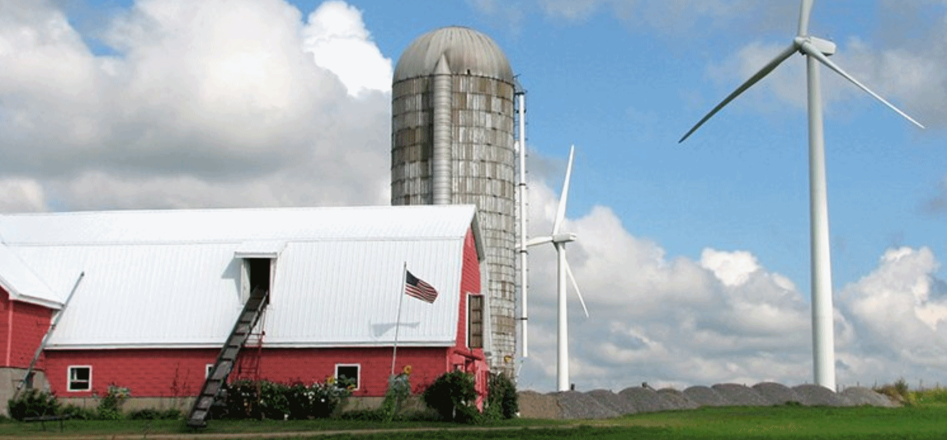
Report: Regional Power Grid Can Handle Much More Gas and Renewables. Here's an excerpt from The Pittsburgh Post-Gazette: "...The
analysis found that PJM could remain reliable “with unprecedented
levels of wind and solar resources” as long as they are mixed with other
types of power generation, like natural gas or nuclear, that can
balance their reliability weaknesses. The study found a marked decrease
in reliability for generation portfolios heaviest in wind and solar,
suggesting that there are limits — probably around 20 percent of
operational capacity — to how much of those types of intermittent
renewables could be integrated into the grid without sacrificing
reliability. The analysis did not try to measure the effects of
potential advances in battery storage or distributed energy..." (Photo credit: Wind on the Wires).

Former Google Vice President Starts a Company Promising Clean and Safe Nuclear Energy. Bloomberg Technology has details: "...Though Cassidy remains an advisor at Google, he has quietly started a new company, Apollo Fusion.
On Friday, a website for the firm, which previously consisted only of a
definition of the phrase “nuclear fusion,” was updated to include a
vision statement that gives a tantalizing peek into Cassidy's plans.
“We're working on revolutionary hybrid reactor technology with fusion
power to serve safe, clean, and affordable electricity to everyone,”
reads the site. “Apollo Fusion power plants are designed for
zero-consequence outcomes to loss of cooling or loss of control
scenarios and they cannot melt down...”

Illustrations by Cam Floyd. Animation by Pablo Espinosa.
TODAY: More clouds, late shower or sprinkle possible. Winds: N 7-12. High: 56
WEDNESDAY NIGHT: Partial clearing, chilly. Low: 34
THURSDAY: Partly sunny and breezy. Winds: N 10-15. High: 53
FRIDAY: Mild sun. Leave work early. Winds: SE 7-12. Wake-up: 36. High: near 60
SATURDAY: Lukewarm sun. Evacuate outdoors. Winds: S 10-20. Wake-up: 45. High: near 70
SUNDAY: T-storms may turn severe. Winds: SW 10-15. Wake-up: 53. High: 72
MONDAY: Unsettled, few showers linger. Winds: NW 10-15. Wake-up: 50. High: 60
TUESDAY: Mostly cloudy, cooler breeze. Winds: NW 10-15. Wake-up: 39. High: 49
Climate Stories...
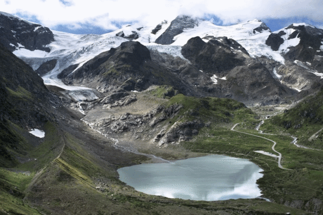
Photo credit: "In this photo provided by James Balog/Extreme Ice Survey and Matthew Kennedy, the Stein glacier in Switzerland in 2015. Over the past decade or so scientists and photographers keep returning to the world’s glaciers, watching them shrink with each visit. Now they want other people to see what haunts them in a series of before and after photos." (Matthew Kennedy/Earth Vision Institute via AP) (Associated Press).
True Conservatives Should Worry About Climate Change. Here's an excerpt of an Op-Ed at The Charlotte Observer: "...To follow Mr. Loris’ recommendations will push the concentration of carbon dioxide above 400 ppm. We are now aware that these choices have consequences for us, for our children and for generations to come. The moral choice has been different over the last 30 years than it was for our grandparents. Mr. Loris cannot simply argue for a limited set of jobs helped by fossil fuels without also accepting the burden we now understand – such as rising sea levels, abnormal precipitation leading to droughts in some areas and flooding or mudslides in others. It is not a conservative value to ignore our impacts on those around us or on the economic conditions we leave for our kids. Thankfully, there are conservative voices speaking out on this issue. Fifteen House Republicans have joined the bipartisan House Climate Solutions Caucus to hold meaningful discussions on what can be done..."
Photo credit: "Burning coal increases carbon dioxide in the air. It’s not a conservative value to not worry about what we are leaving our children." Matthew Brown AP.
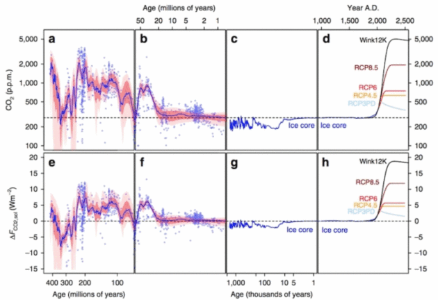
Graphic credit: "Atmospheric carbon dioxide levels could reach a level unseen in 50 million years by the 2050s. If they continue rising into the 2200s, they'll create a climate that likely has no precedent in at least 420 million years." Credit: Foster, et al., 2017.
Photo credit: "What we need to talk about when we talk about climate change." (AP Photo/Charlie Riedel)

Photo credit: "Former New York Mayor and U.N. Special Envoy for Cities and Climate Change Michael Bloomberg speaks during the C40 Cities Women4Climate event in New York City, U.S., March 15, 2017." REUTERS/Brendan McDermid.
What Financial Markets Can Teach Us About Managing Climate Risks. The New York Times reports.
The End of Winter May Signal Bigger Changes Ahead for Earth's Climate. An Op-Ed at USA TODAY captures the sense of disbelief that facts, data and evidence have become optional and politicized: "...We have no trouble believing that dinosaurs lived 150 million years ago, but who can even count back that far? We take it on faith that the continents drift around on tectonic plates like ice floes in a slush pond, but the ground feels pretty stable to me. Even though none of us can independently verify any of these things, most of us accept them as facts, not assertions. We recognize them as the settled conclusions of qualified experts who have studied the evidence carefully and ruled out every competing hypothesis. That’s what science does; it extends our reach and allows us to make connections, connect dots, that we couldn’t possibly link on our own. If we accepted only the evidence of our senses, we’d still think that the Earth was flat and the sun and stars revolved around us. When it comes to climate change, however, the Earth is still flat. Scientific facts have somehow become opinions, and carefully researched conclusions are written off as theories or even hoaxes. Climate scientists went to the same schools, earned the same degrees, and follow the same protocols as experts we wouldn’t begin to question on other matters, but millions of us find it easy to say, “I don’t think so....”
Image credit: Jeff Williams, NASA.
Climate Change Doesn't Care Who You Voted For. Here's a clip from Teen Vogue. What, you don't read Teen Vogue? "...Climate change denial has been able to flourish because it papers over a painful reality. It’s hard to reconcile the scope of danger with the sense that there is nothing we can do about it, but political inefficacy is just another myth in need of rejection. We must come together to insist on the reduction of greenhouse-gas emissions via federal effort. Each passing day in this DEFCON 1 political climate, it seems less and less possible to bridge the party divide, but we can all be united by the need for clean air, fresh water, and a better world for our children. As it stands, Trump’s climate change policy puts all of those things at risk, and unfortunately floods and droughts don’t give a crap whom you voted for."

No comments:
Post a Comment