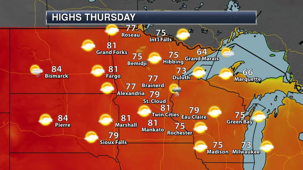
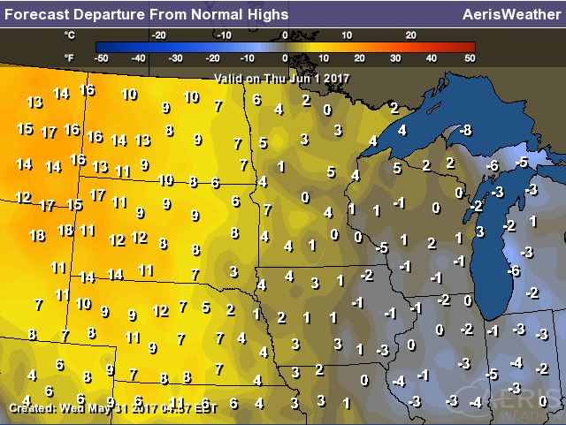
Weather Outlook For Thursday
High temperatures on Thursday will warm into the 70s and lower 80s across much of the state, which will be slightly above average for most locations. With mostly sunny skies, Thursday will be one of the nicest days of the week, enjoy! Note that temperatures across central and western North and South Dakota will be nearly 10F to 20F above average.
UV Index for Thursday - HIGH
Mild temperatures and mostly sunny skies will likely have many spending more time outside on Thursday. Keep in mind that the UV Index will be considered HIGH across much of the state of Minnesota, which means that it will only 25 to 30 minutes or less to burn unprotected skin. With that said, if you are planning on spending any extended length of time outside, make sure you wear appropriate attire and lather on the sun block!
"How Do the Chemicals in Sunscreen Protect Our Skin from Damage?"
"Recognition of the risks posed by UV rays has motivated scientists to study what’s going on in our cells when they’re in the sun—and devise modern ways to ward off that damage. The good news, of course, is that the risk of skin cancer and the visible signs of aging can be minimized by preventing overexposure to UV radiation. When you can’t avoid the sun altogether, today’s sunscreens have got your back (and all the rest of your skin too). Sunscreens employ UV filters: molecules specifically designed to help reduce the amount of UV rays that reach through the skin surface. A film of these molecules forms a protective barrier either absorbing (chemical filters) or reflecting (physical blockers) UV photons before they can be absorbed by our DNA and other reactive molecules deeper in the skin."
(Image credit: Thomas Trutschel Getty Images via ScientificAmerican)

_____________________________________________________________
Sticky Weather Ahead - "It's Too Hot"
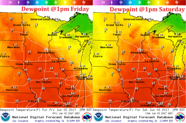
Some of the stickiest air of the season is on the way for Friday and Saturday as dewpoints rise into the 60s across much of the southern half of the state. Note that dewpoints in the 50s are noticeable, while dewpoints in the 60s are humid and dewpoints in the 70s are oppressive! With that said, you'll likely here a few folks muttering the all too familiar summer phrase "It's too hot".
"This Is What Heat Stroke Does To Your Body"
If you’re experiencing these symptoms, seek cooler temperatures ASAP - In 2014, more than 13,000 people visited the emergency room because of a heat-related illness such as heat stroke, according to data from the Centers for Disease Control. And on average, about 675 people die in the U.S. every year from heat-related illnesses.
Heat stroke is the most severe form of heat-related illness. It’s less common than other issues such as heat exhaustion (characterized by heavy sweating, weakness, cold, pale or clammy skin, fainting, a fast or weak pulse, and nausea or vomiting) or heat syncope (fainting). But heat stroke can happen quickly, to anyone, and can result in irreversible damage or death.
See more from HuffingtonPost.com HERE:
(LZF VIA GETTY IMAGES via HuffingtonPost)
_________________________________________________________________________
Weather Outlook
Scattered showers and a few strong to severe thunderstorms maybe possible in a few spots over the next few days, but the extended forecast isn't suggesting any major severe weather outbreaks anytime soon. While May and June tend to be very active months for severe weather across the nation, weather conditions as of late have been very quiet and look to remain fairly quiet into the weekend ahead.
.gif)
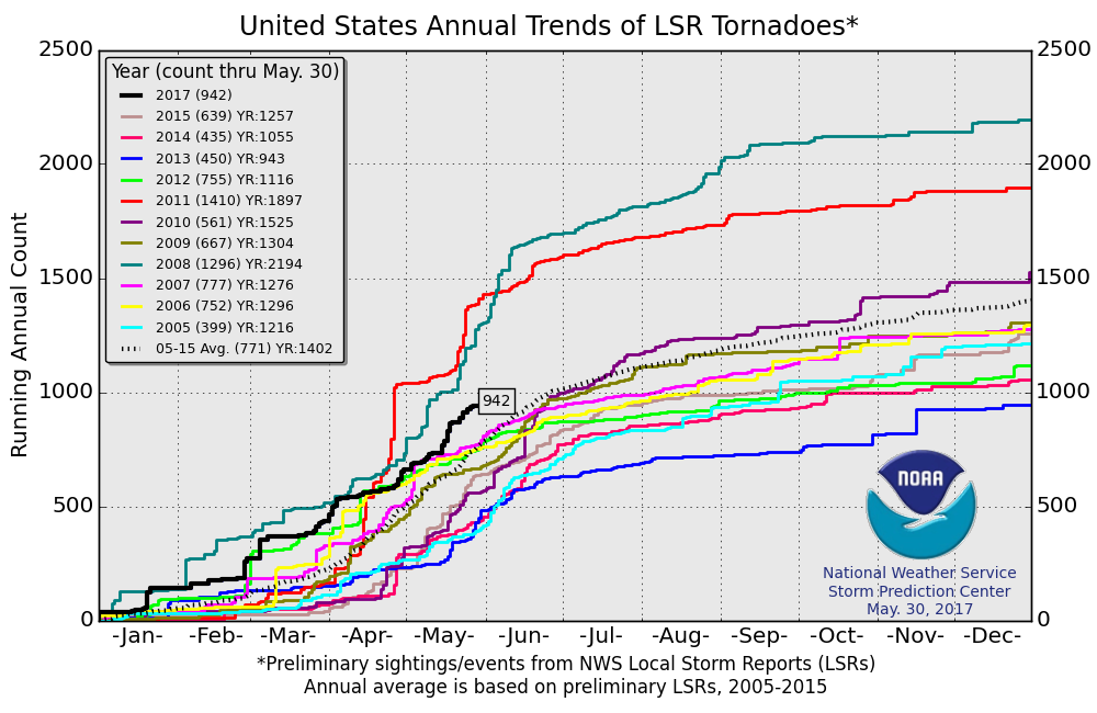
PRELIMINARY 2017 Tornado Count
According to NOAA's SPC, the PRELIMINARY 2017 tornado count is 942 (through May 30). Note that is the most active year for tornadoes since 2011, when there were nearly 1,400 tornadoes. Keep in mind there was a major tornado outbreak in the Gulf Coast region from April 25-28, 2011 that spawned nearly 500 tornadoes, some of which were deadly. That outbreak is known as the Super Outbreak of 2011 and has gone down in history as one of the biggest, costliest and one of the deadliest tornado outbreaks in history.
 Average Tornadoes in June
According to NOAA's NCDC, June is the 2nd busiest month for tornadoes behind May across the country, averaging 243! Note that most of these tornadoes occur across the Plains from Texas to Nebraska, which is also in a region known as "Tornado Alley". As it stands now, May was the busiest tornado month of the year thus far with a preliminary total of 278.
Average Tornadoes in June
According to NOAA's NCDC, June is the 2nd busiest month for tornadoes behind May across the country, averaging 243! Note that most of these tornadoes occur across the Plains from Texas to Nebraska, which is also in a region known as "Tornado Alley". As it stands now, May was the busiest tornado month of the year thus far with a preliminary total of 278.
________________________________________________________________________
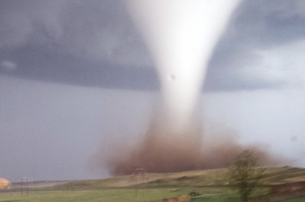
"Understanding tornadoes: 5 questions answered"
We asked meteorology professors Paul Markowski and Yvette Richardson to explain why tornadoes form...
1. Where are tornadoes most likely to occur?
2. How do actual tornadoes form?
3. How precisely can we predict tornado strikes?
4. What should I do during a tornado warning?
5. Is climate change making tornadoes bigger or more frequent?
See more from Salon.com HERE:
[This photo taken on Monday, May 26, 2014 and provided by Jill Helmuth, shows a tornado touching down on a reach before heading towards Watford City, N.D. Authorities say several were injured and more than a dozen trailers were damaged or destroyed Monday evening when the twister tore through a camp where oil field workers stay. (Credit: AP Photo/Jill Helmuth via Salon.com)]
 ___________________________________________________________________Tropical Depression Two-E Forms in Eastern Pacific
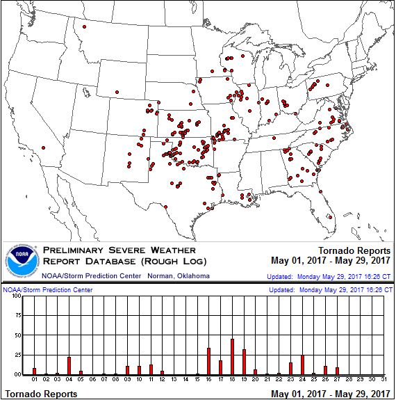
May 2017 Tornado Count
According to NOAA's SPC, there were nearly 280 PRELIMINARY tornadoes across the country in May (1st - 29th). We'll have to wait a while for the final numbers to come in, but it is likely that May will finish close normal, which averages 276 tornadoes and is the busiest month of the year for tornadoes across the nation.
________________________________________________________________________
"Understanding tornadoes: 5 questions answered"
We asked meteorology professors Paul Markowski and Yvette Richardson to explain why tornadoes form...
1. Where are tornadoes most likely to occur?
2. How do actual tornadoes form?
3. How precisely can we predict tornado strikes?
4. What should I do during a tornado warning?
5. Is climate change making tornadoes bigger or more frequent?
See more from Salon.com HERE:
[This photo taken on Monday, May 26, 2014 and provided by Jill Helmuth, shows a tornado touching down on a reach before heading towards Watford City, N.D. Authorities say several were injured and more than a dozen trailers were damaged or destroyed Monday evening when the twister tore through a camp where oil field workers stay. (Credit: AP Photo/Jill Helmuth via Salon.com)]
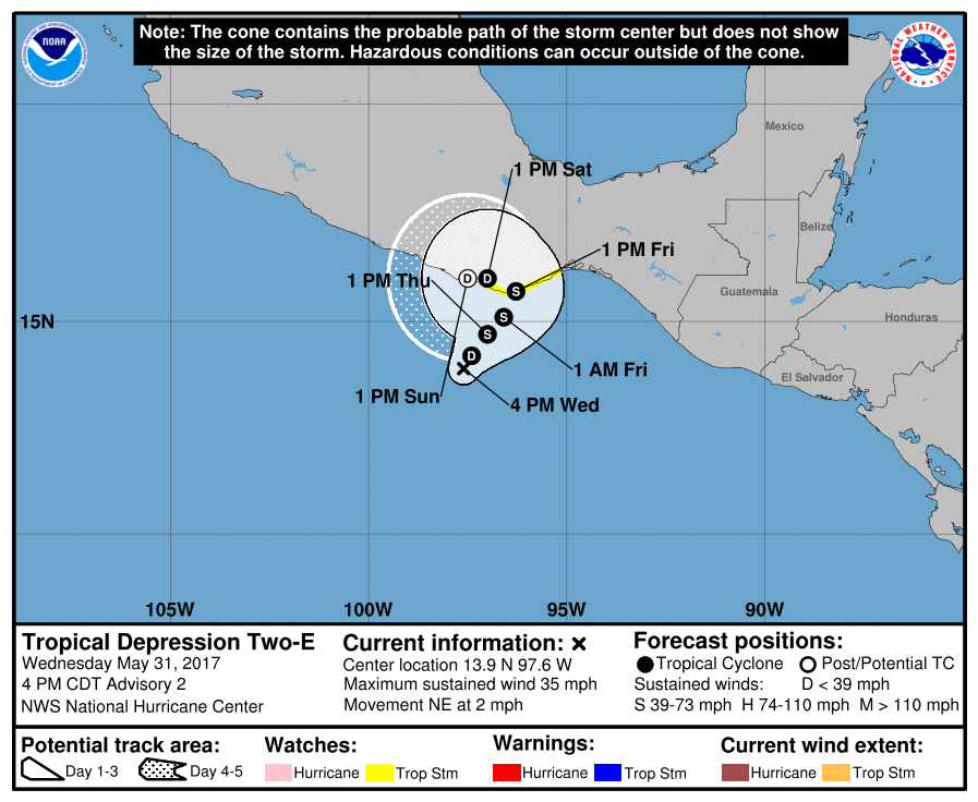
NOAA's NHC is keeping an eye on a wave of energy in the Eastern Pacific, which as of midday Wednesday formed into Tropical Depression TWO-E. Keep in mind that the official Eastern Pacific Hurricane Season started May 15th and lasts until November 30th. Interestingly, we've already had one named storm in the Eastern Pacific this season. "The depression became the earliest-forming East Pacific tropical cyclone (east of 140°W) on record. The previous record was held by 1990's Hurricane Alma, which formed on May 12.[9] The depression intensified into Tropical Storm Adrian six hours later, the earliest-known formation of a named storm in eastern Pacific proper since the advent of the satellite era.[10]"
[9].Doyle Rice (May 9, 2017). "Earliest Pacific tropical depression on record forms". USA Today. Retrieved May 9, 2017.
[10] Stacy R. Stewart (May 9, 2017). Tropical Storm Adrian Public Advisory Number 2 (Report). Miami, Florida: National Hurricane Center. Retrieved May 9, 2017.
[10] Stacy R. Stewart (May 9, 2017). Tropical Storm Adrian Public Advisory Number 2 (Report). Miami, Florida: National Hurricane Center. Retrieved May 9, 2017.
Tracking the Tropical System
As of Wednesday, NOAA's NHC forecast for Tropical Depression TWO-E suggested that this particular storm could become Tropical Storm Beatriz as early as Thursday and potentially make a close encounter with the Mexican Coast by Friday.
________________________________________________________________
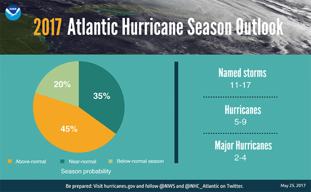
Atlantic Hurricane Season Officially Starts June 1
June 1st not only marks the beginning of meteorological summer in the northern hemisphere (warmest 3 months of average; June-July-August), but it also marks the official start of the Atlantic Hurricane Season. The season starts on June 1st and lasts until November 30th, with the peak occurring around September 10th. Interestingly, we have already had our first storm of the season, Arlene, which developed April 20th. Arlene became the 2nd only named storm to develop in the month of April since the modern state era.
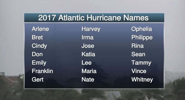
2017 Atlantic Hurricane Season Forecast
NOAA recently released their tropical outlook, which calls for a 45% chance of an above average season with 11-17 named storms and 5-9 total hurricanes, 2-4 of which will be major hurricanes with wind speeds in excess of 110mph. Experts their believe that "weak or non-existent El Nino, near or above-average sea surface temperatures across the Atlantic, and average or weaker-than-average vertical winds shear" could help to produce more storms this season. Note that an average season produces 12 named storms, six of which become hurricanes, including three major hurricanes (Category 3 or higher).
"These numbers include Tropical Storm Arlene, a rare pre-season storm that formed over the eastern Atlantic in April. “The outlook reflects our expectation of a weak or non-existent El Nino, near- or above-average sea-surface temperatures across the tropical Atlantic Ocean and Caribbean Sea, and average or weaker-than-average vertical wind shear in that same region,” said Gerry Bell, Ph.D., lead seasonal hurricane forecaster with NOAA’s Climate Prediction Center. Strong El Ninos and wind shear typically suppress development of Atlantic hurricanes, so the prediction for weak conditions points to more hurricane activity this year. Also, warmer sea surface temperatures tend to fuel hurricanes as they move across the ocean. However, the climate models are showing considerable uncertainty, which is reflected in the comparable probabilities for an above-normal and near-normal season."
_____________________________________________________________
Weekend Weather Now Looks A Bit More Promising
By Paul Douglas
By Paul Douglas
The world isn't ending, not yet, but it is warming. That's not from a much-maligned climate model but based on actual observations.
But it's human nature to react to day-to-day weather, not slow shifts in climate.
"But Paul, wasn't it hotter in the 1930s? We had a Dust Bowl don't you know!" On May 31, 1934 the mercury hit 106F in Minneapolis, 107F at St. Paul and 110F at Rush City! Careful analysis shows that record heat (several years when 100s were prevalent) were regional in scope. It wasn't a global phenomenon, but a heat spike limited to the Great Plains and central USA.
No heat waves are brewing, but 80s and sticky dew points topping 60F are likely by Friday and Saturday. This sudden summer surge ignites a few strong to severe T-storms, especially Friday night into Saturday morning. Sunday still looks like the drier day with a drop in humidity and low 70s.
According to NOAA only 4 percent of the USA is in drought right now. That's the lowest percentage since regular observations were started in 2000. That compares to 65 percent in September, 2012. Good news, right?
_______________________________________________________
_______________________________________________________
Extended Forecast
THURSDAY: Warm sunshine. Winds: S 5-10. High: 80
THURSDAY NIGHT: Mostly clear and quiet. Winds: SE 5. Low: 60.
FRIDAY: Some sticky sun, strong T-storms late. Winds: SE 7-12. High: 83
SATURDAY: Unsettled, more showers, T-storms. Winds: NW 8-13. Wake-up: 64. High: 81
SUNDAY: Drier and less humid with some sun. Winds: NE 7-12. Wake-up: 61. High: 73
MONDAY: Patchy clouds, stray showers? Winds: NE 7-12. Wake-up: 55. High: 70
TUESDAY: Sunny pleasant. Winds: NE 5-10. Wake-up: 52. High: 75
WEDNESDAY: Blue sky, warming up. Winds: E 5-10. Wake-up: 55. High: 79.
_______________________________________________________
_______________________________________________________
This Day in Weather History
June 1st
June 1st
1993: St. Cloud records its latest ever freezing temperature, with a record low of 32.
________________________________________________________
________________________________________________________
Average High/Low for Minneapolis
June 1st
June 1st
Average High: 74F (Record: 92F set in 1939)
Average Low: 54F (Record: 37F set in 1946)
Average Low: 54F (Record: 37F set in 1946)
Record Rainfall: 2.37" set in 2014
_________________________________________________________
_________________________________________________________
Sunrise/Sunset Times for Minneapolis
June 1st
June 1st
Sunrise: 5:30am
Sunset: 8:52pm
Sunset: 8:52pm
Daylight gained since yesterday: ~1mins & 23secs
Daylight gained since winter solstice (December 21st): ~6hours & 37mins
Additional Daylight Gained By Summer Solstice (June 20th): ~ 13min
__________________________________________________________
Daylight gained since winter solstice (December 21st): ~6hours & 37mins
Additional Daylight Gained By Summer Solstice (June 20th): ~ 13min
__________________________________________________________
Moon Phase for May 31st at Midnight
0.2 Days Before First Quarter
0.2 Days Before First Quarter
_____________________________________________________________
Weather Outlook for Thursday
Winds will finally be a little tamer across the region on Thursday. Instead of gusty west to northwesterly winds, we will have more of a southerly wind, which will help to pump warmer air into the region through the end of the week!
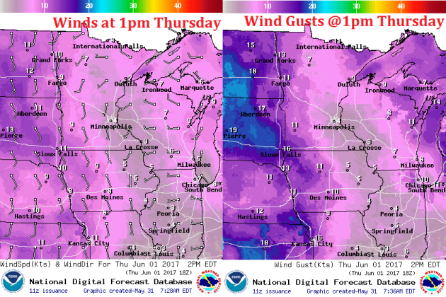
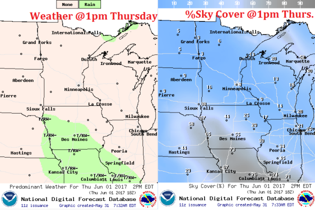
Thursday will be another bright, sunny day across the region with only a few clouds drifting in across the southerly part of the state late in the day. Enjoy it because clouds will be on the increase Friday through the weekend with widely scattered showers and storms then.
Warm Sunny Thursday - Cool & Soggy Weekend
Here's the weather outlook from Thursday to AM Monday of early next week. Thursday and Friday will be very mild across much of the region, but cool and soggy weather looks to return as we head into the weekend. Storms, some of which could be strong to severe, could develop as early as PM Friday. The moisture expected to push through the region over the next 5 days could be locally heavy.
.gif)
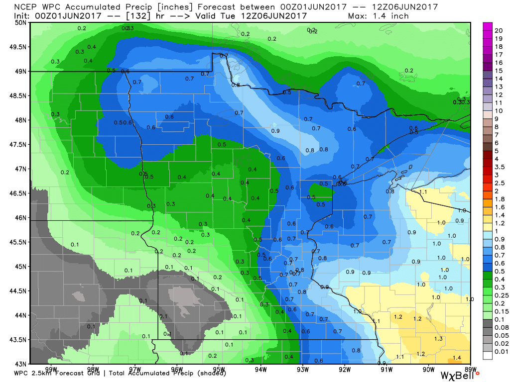
Extended Rainfall Forecast
Here's the extended rainfall forecast through early next week, which suggests some 0.50"+ rainfall tallies across parts of Minnesota and Wisconsin. Some of this locally heavy rain could even impact the Twin Cities through the weekend. Stay tuned...
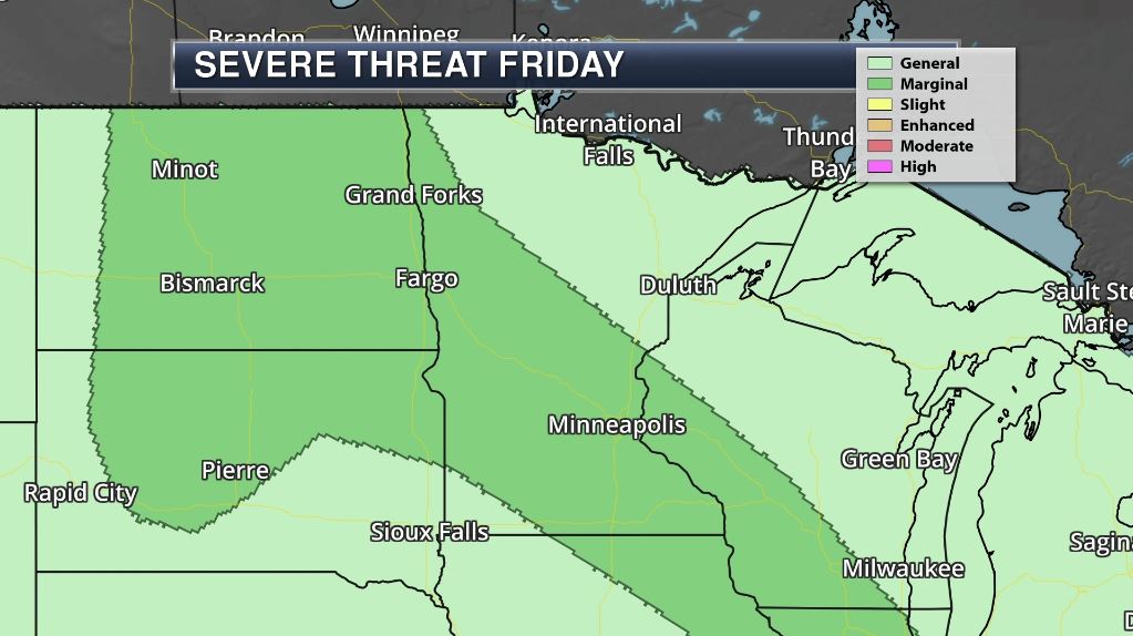
Severe Threat Friday?
According to NOAA's SPC, there is a Marginal Risk of severe weather across parts of Minnesota on Friday. As warmer, more humid weather streams into the region, showers and storms will develop, some of which could be strong to severe with locally heavy rainfall possible. Stay tuned for more...
_________________________________________________________________
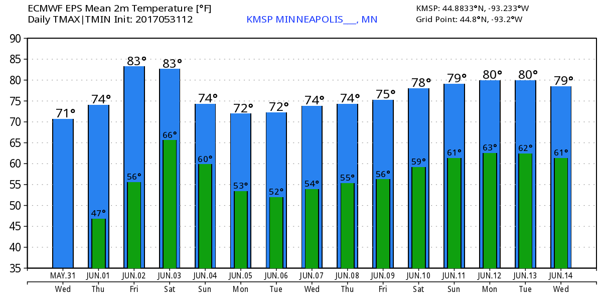
Temperature Outlook
Here's the temperature outlook through the middle part of June, which suggests warmer temperatures bubbling back into the region over the next couple of weeks. Note that there maybe a little cool down into the first full week of June, but we should be able to recover by the 2nd weekend of June with highs in the mid to upper 70s.
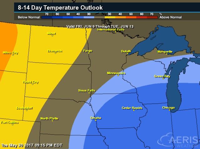
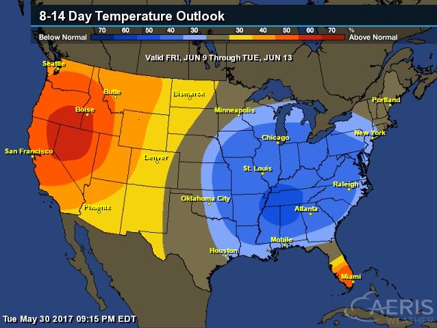
8 to 14 Day Temperature Outlook
According to NOAA's CPC, the extended temperature outlook through June 13th suggests warmer than average temperatures settling in across the High Plains, while cooler than average temperatures linger across the Great Lakes, Ohio Valley and Middle Mississippi Valley.
___________________________________________________________
Extended Temperature Outlook
According to NOAA's CPC, the extended temperature outlook through June 13th shows much cooler than average temperatures lingering across the Eastern half of the country, while warmer than average temperatures continue in the Western US.
 ____________________________________________________________
Temperature Trend
Here's the temperature trend through the end of next week. Note that while we initially appear to warm across the central part of the country this weekend, cooler than average weather looks to develop and build across the eastern half of the country into the first full week of June. Meanwhile, much of that time period will remains warmer than average in the western half of the country.
Despite any major severe weather outbreaks looming, summertime heat and humidity will allow scattered showers and storms to bubble up in a few areas over the next several days. Some of the storms may produce isolated strong to severe storms and locally heavy rainfall in the coming days.
5 Day Precipitation Outlook
According to NOAA's WPC, the next several days could produce areas of locally heavy rainfall in the Eastern half of the country. Some locations could see as much as 1" to 2"+ through early next week, while areas in the Southwest will stay dry.
 ____________________________________________________________________
"Lyme Isn’t the Only Disease Ticks Are Spreading This Summer"
"What changed? The weather. Two years of mild winters has tick populations booming. And Molaei expects to see more of the same, as climate change makes warmer winters in the northeastern US more common. Studies show that warmer-than-normal temperatures increase tick reproduction two to five times. As agricultural land increasingly turns back to forest and suburbs continue to encroach on these newly wild areas, people are also getting more and more opportunities to encounter ticks, and POW."
(Image Credit: ED RESCHKE/GETTY IMAGES via Wired.com)

"Terrifying footage emerges from raging storm in Moscow"
"Moscow was battered by a deadly barrage of severe thunderstorms on Monday, and plenty of scary moments were caught on video. At least 11 people have died in the storm, with dozens reported injured across the Moscow metropolitan area. According to the BBC, if that death toll is confirmed, it would be the city's deadliest storm in a century. "Winds gusted as high as 70 mph during the storm, which is rare for Moscow," meteorologist Brian Donegan said on weather.com. "Some hail was also reported along with torrential rain." The wind speeds and geographic scope of the storm — Moscow is a sprawling city home to 12 million — points to straight-line winds as a likely culprit for much of the damage."

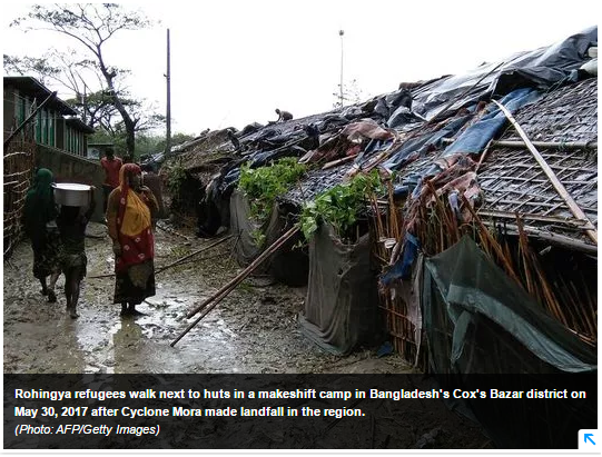
"Cyclone Mora: Bangladesh storm kills 3, destroys thousands of homes"
Bangladesh — A tropical storm lashed southern Bangladesh on Tuesday, killing at least three people and destroying thousands of poorly built homes in some remote islands in the Bay of Bengal, officials said. Tropical Storm Mora started crossing the country’s southern coastal region early in the day. Some 300,000 people had been moved to safety or were evacuated on Monday as the delta nation braced for its first strong storm of the year. More than 1,000 shelters were set up in several districts, including Cox’s Bazar and Chittagong, and more than 20,000 volunteers were on hand. Cox’s Bazar’s chief government administrator, Ali Hossain, said two women and a man died in three separate incidents after the storm made landfall. Two of them died after trees fell on their homes, he said. Some 20,000 homes were destroyed in the vast region, Hossain said. “We are estimating actual losses, but we don’t expect huge casualties,” he said.
(Image credit: AFP/Getty Images Via USAToday)
"Climate change is literally keeping us up at night"
"Rising temperatures caused by climate change seem to be disrupting America’s sleep patterns, according to a new study. A temperature increase of 1.8 degrees Fahrenheit causes three bad nights of sleep per 100 individuals per month. Across the United States, that amounts to 9 million sleepless nights a month and 110 million nights each year. “Our study represents the largest ever investigation of the relationship between sleep and ambient temperature,” the authors wrote, “and provides the first evidence that climate change may disrupt human sleep.” Scientists have long known that a comfortable body temperature is key for a good night’s sleep. But this research is the first to find a correlation between hotter-than-usual nights and an increase in self-reported sleeplessness. The findings were published May 26 in Scientific Advances."
See more from NYPost.com HERE:
(Image credit: Shutterstock via NYPost.com)
 ______________________________________________________________________"Climate change could make cities 8C hotter – scientists"
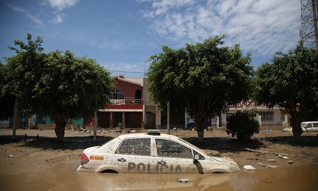
"Combination of carbon emissions and ‘urban heat island’ effect of concrete and asphalt gives rise to worst-case scenario by end of 21st century. Under a dual onslaught of global warming and localised urban heating, some of the world’s cities may be as much as 8C (14.4F) warmer by 2100, researchers have warned. Such a temperature spike would have dire consequences for the health of city-dwellers, rob companies and industries of able workers, and put pressure on already strained natural resources such as water. The projection is based on the worst-case scenario assumption that emissions of greenhouse gases continue to rise throughout the 21st century. The top quarter of most populated cities, in this scenario, could see temperatures rise 7C or more by century’s end, said a study in the journal Nature Climate Change. For some nearly 5C of the total would be attributed to average global warming. The rest would be due to the so-called “urban heat island” effect, which occurs when parks, dams and lakes, which have a cooling effect, are replaced by concrete and asphalt – making cities warmer than their surrounds, the researchers said."
See more from TheGuardian HERE:
(Image Credit: The median city stands to lose between 1.4 and 1.7% of GDP per year by 2050 due to climate change. Photograph: Anadolu Agency/Getty Images via The Guardian)
 ________________________________________________________________"Research uses heat to predict species most threatened by climate change"
Climate change is a threat to all species, but which species will be under the greatest threat? The question is at the centre of research by a Monash University biologist Dr Vanessa Kellermann, who examines heat resistance – or 'thermal history' - to determine which species will suffer more as a result of climate change. The latest development in Dr Kellermann's work was published recently in Proceedings of the Royal Society B. "Getting accurate predictions of a species' risk to climate change is no easy task," Dr Kellermann said. "One way is to take species from the field and estimate heat resistance and see how close this estimate is to future climate projections," she said. The closer a species' heat tolerance is to maximum temperature of the environment the more at risk a species is to climate change. However, estimates of heat tolerance might be influenced by the environment a species is collected from.
See more from Phys.org HERE:
(Drosophila melanogaster. Credit: Dr Andrew Weeks via Phys.org)
___________________________________________________________________
See more from NYPost.com HERE:
(Image credit: Shutterstock via NYPost.com)
"Combination of carbon emissions and ‘urban heat island’ effect of concrete and asphalt gives rise to worst-case scenario by end of 21st century. Under a dual onslaught of global warming and localised urban heating, some of the world’s cities may be as much as 8C (14.4F) warmer by 2100, researchers have warned. Such a temperature spike would have dire consequences for the health of city-dwellers, rob companies and industries of able workers, and put pressure on already strained natural resources such as water. The projection is based on the worst-case scenario assumption that emissions of greenhouse gases continue to rise throughout the 21st century. The top quarter of most populated cities, in this scenario, could see temperatures rise 7C or more by century’s end, said a study in the journal Nature Climate Change. For some nearly 5C of the total would be attributed to average global warming. The rest would be due to the so-called “urban heat island” effect, which occurs when parks, dams and lakes, which have a cooling effect, are replaced by concrete and asphalt – making cities warmer than their surrounds, the researchers said."
See more from TheGuardian HERE:
(Image Credit: The median city stands to lose between 1.4 and 1.7% of GDP per year by 2050 due to climate change. Photograph: Anadolu Agency/Getty Images via The Guardian)
Climate change is a threat to all species, but which species will be under the greatest threat? The question is at the centre of research by a Monash University biologist Dr Vanessa Kellermann, who examines heat resistance – or 'thermal history' - to determine which species will suffer more as a result of climate change. The latest development in Dr Kellermann's work was published recently in Proceedings of the Royal Society B. "Getting accurate predictions of a species' risk to climate change is no easy task," Dr Kellermann said. "One way is to take species from the field and estimate heat resistance and see how close this estimate is to future climate projections," she said. The closer a species' heat tolerance is to maximum temperature of the environment the more at risk a species is to climate change. However, estimates of heat tolerance might be influenced by the environment a species is collected from.
See more from Phys.org HERE:
(Drosophila melanogaster. Credit: Dr Andrew Weeks via Phys.org)
___________________________________________________________________
Thanks for checking in and don't forget to follow me on Twitter @TNelsonWX

No comments:
Post a Comment