Summer's Bounty
It was a good day in the garden yesterday with raspberries really starting to ripen. It's a race to see who gets there first! Me or the birds... My tomato plants have lots of green tomatoes on them and aren't far behind. Happy Gardening!!

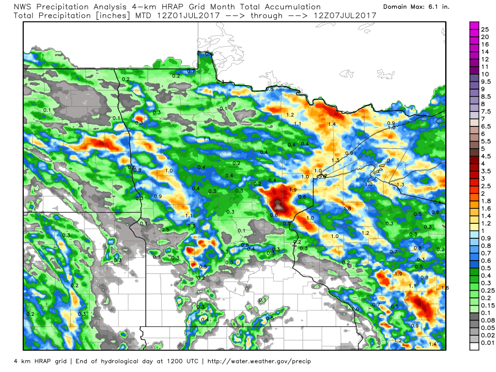
Rainfall Estimates So Far This Month
Here's the radar estimated rainfall for the month of July. Note that much of southern Minnesota has been completely dry through the first 7 days of the month, while some folks in central and northern Minnesota have seen up to a couple of inches after several rounds of thunderstorms moved through the area.
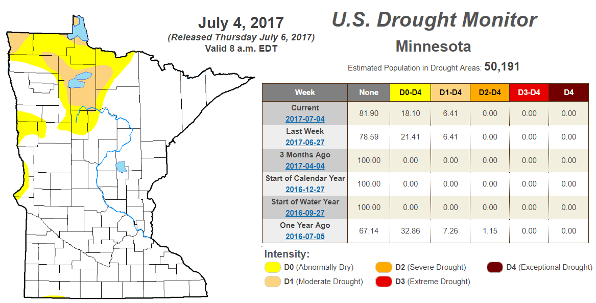
Minnesota Drought Outlook
According to the US Drought Monitor, 6.41% of Northwestern Minnesota are still in a Moderate Drought, while nearly 18% of the state is still considered to be abnormally dry. Note that the abnormally dry conditions have decreased from nearly 21% since last week.
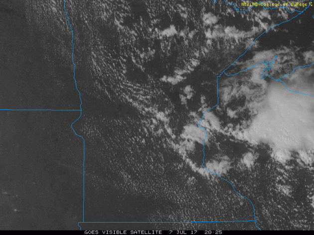
Visible Satellite From Friday
Here's the visible satellite loop from Friday afternoon, which showed the spotty showers and storms that popped up during the day across parts of northeastern Minnesota and into Wisconsin. A few of these storms just clipped the eastern side of the Twin Cities.
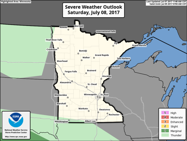
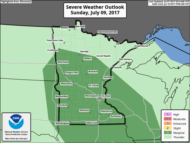
Here's the severe weather outlook from NOAA's Storm Prediction Center for Saturday & Sunday across the region. The good news is that there is no rain or thunder threat anywhere across the state on Saturday, but according to NOAA's SPC, there is a MARGINAL risk of severe storms for Sunday. Stay tuned...
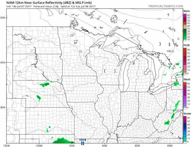
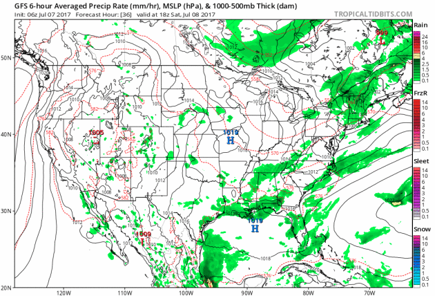
Simulated Radar
Here's the simulated radar from Saturday to Monday night, which shows very quiet weather for Saturday, but another weak wave of energy could promote thundershower development across parts of Minnesota during the day Sunday. Keep in mind that there is a MARGINAL risk of severe weather across parts of the state, so some of the storms could get a little aggressive.
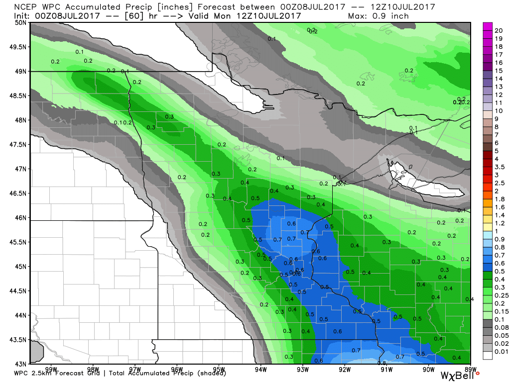
Rainfall Potential Through AM Monday
Here's the rainfall potential through 7AM Monday, which suggests another round of potentially locally heavy rainfall moving into the region Sunday/Sunday night. According to this particular model, some locations across Central and Southeastern MN could see up to 0.5" or more!
Comfortable Saturday, but a bit muggy Sunday
Dewpoints on Friday were very comfortable with readings in the 50s! Saturday will be another comfortable day with dewpoints still holding in the 50s across the state. A weak impulse of energy looks to move into the region on Sunday, which will help to boost dewpoints back into the lower/middle 60s. With that said, Sunday looks to be a bit muggy, but hey... It's summer!

___________________________________________________________________________
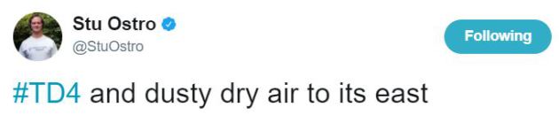
A View of Tropical Depression #4
Here's a cool picture of Tropical Depression #4 from late last week as Tropical Depression #4 (bright white cloud mass on far left side) is seen drifting west of a major dust plume east of it! Very cool. The tweet originated from @StuOstro - a good follow on Twitter if you're interested!
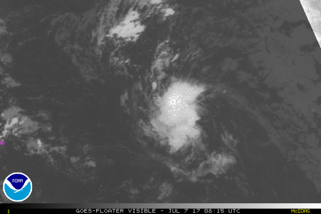
Atlantic Outlook: Tropical Depression #4 Has Faded...
Here's a visible satellite loop of what was Tropical Depression #4 from early Friday morning. At this point, TD #4 looked pretty lame. Not much circulation or organization can be seen here. TD #4 had a hard time getting going as it encountered dry air and a little more upper level wind shear; 2 things that tropical system don't like.
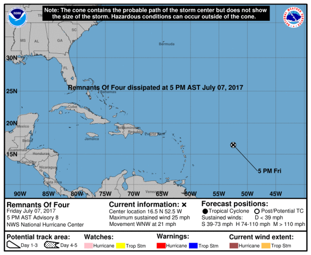
Atlantic Outlook
According to NOAA's NHC, the remnants of Tropical Depression #4 will continue to drift northwest through the Central Atlantic over the next few days. At this point, the system looks to remain below tropical depression status.
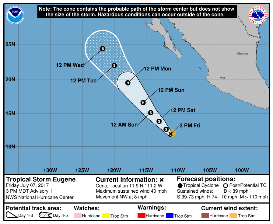
Well the big cloud blog in the Eastern Pacific finally formed into Tropical Storm EUGENE. According to NOAA's NHC, EUGENE formed on Friday and became the 5th named storm of the 2017 Eastern Pacific Hurricane Season.
Here's the official track for Tropical Storm EUGENE, which suggests it potentially gaining hurricane status by Sunday! It it does, it would become the 2nd storm to achieve that status in the Eastern Pacific this season. DORA was the other storm that became a hurricane in late June. The good news is that at this point, EUGENE will continue to drift northwest away from any major landmass.
 ______________________________________________________________________
1.) Much above-normal temperatures for much of the northern and central Rockies and northern and central Great Plains, Mon-Fri, Jul 10-14.
2.) Excessive heat for parts of the middle Mississippi Valley and lower Ohio Valley, Wed-Fri, Jul 12-14.
3.) Much above-normal temperatures for the upper Yukon Valley of Alaska, Mon-Fri, Jul 10-14.
4.) Heavy rain for the upper Mississippi Valley and Great Lakes, Mon-Wed, Jul 10-12.
5.) Flooding possible across parts of Oklahoma.
6.) Flash flooding, due to locally heavy rain, for parts of the southwestern U.S., July 15-21.
7.) High risk of much above-normal temperatures for the northern Great Plains, Sat-Sun, Jul 15-16.
8.) Moderate risk of much above-normal temperatures for portions of the northern Rockies and northern to central Great Plains, Sat-Mon, Jul 15-17.
9.) Slight risk of much above-normal temperatures for much of the western and central U.S., Sat-Fri, Jul 15-21.
10.) Slight risk of much above-normal temperatures for parts of interior Alaska, Sat, Jul 15.
11.) Severe Drought across parts of the Great Plains, Arizona, California, and Hawaii.
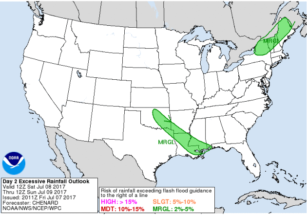
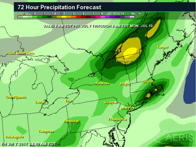
Excessive Rainfall Potential Saturday & Sunday
According to NOAA's WPC, there is a risk of excessive rainfall on Saturday and Sunday across parts of the country. Note that Saturday's risk is mainly confined to the Northern New England States and across parts of the Southern US, while Sunday's risk is confined to parts of the Upper Midwest (including the Twin Cities) and also across parts of the Eastern Carolinas. Note that there is a SLIGHT risk of excessive rainfall across parts of the Midwest by Sunday night.
With excessive rainfall potential in place over parts of the Northeast on Saturday, here's a look at how much rain could fall. According to the forecast below, some locations could see up to 1" to 2"+ rainfall through the weekend.
________________________________________________________
Weather Outlook
Here's the weather outlook through the middle part of next week. Areas of thunderstorms and heavy rainfall will be possible across the Northeast and Southern US on Saturday, while pockets of thunderstorms and heavy rain will be possible across the Upper Midwest and the Carolinas on Sunday. As we head into the early part of next week, it still appears that somewhat unsettled weather will be found across the Upper Midwest, which could help to produce areas of heavy rain and possibly even some strong/severe weather. Meanwhile, the heat in the Western US will help to produce spotty showers and storms with monsoonal storms developing across the Desert Southwest.
_________________________________________________________________
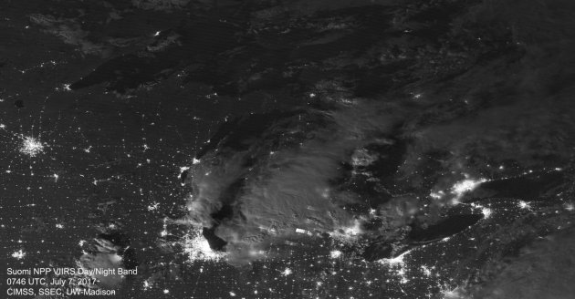
Moonlit Storms Over the Great Lakes
WOW! Here's a cool picture from a NASA satellite that captured thunderstorms from Thursday night as they rumbled over the Great Lakes Region. Interestingly, you can actually see individual lightning strikes lightning up the clouds, while several large light clusters can be see from city lights across the region! Great picture!
______________________________________________________________
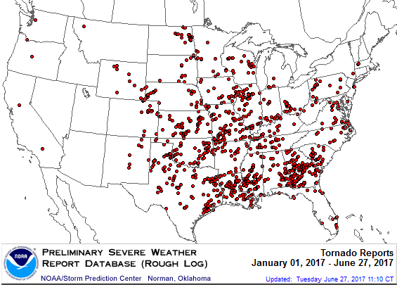
PRELIMINARY 2017 Tornado Map
It certainly has been a fairly active first half of 2017 with 1131 preliminary tornado reports through July 6th. Note that this is the most tornadoes through July 6th since 2011, when there were nearly 1,600 reports. The map below shows the distribution of the tornadoes so far this year.
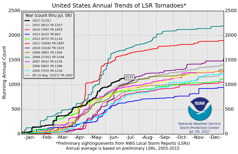
PRELIMINARY 2017 Tornado Count
According to NOAA's SPC, the PRELIMINARY 2017 tornado count is 1131 (through July 6). Note that is the most active year for tornadoes since 2011, when there were nearly 1,600 tornadoes. Keep in mind there was a major tornado outbreak in the Gulf Coast region from April 25-28, 2011 that spawned nearly 500 tornadoes, some of which were deadly. That outbreak is known as the Super Outbreak of 2011 and has gone down in history as one of the biggest, costliest and one of the deadliest tornado outbreaks in history.
_________________________________________________________________
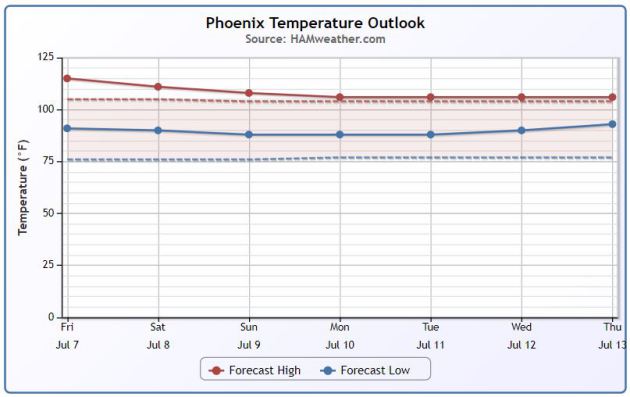
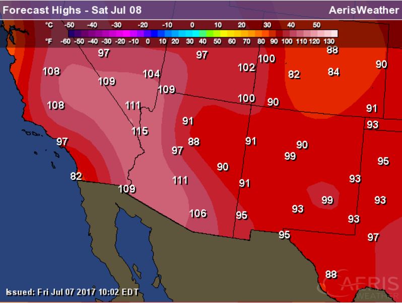
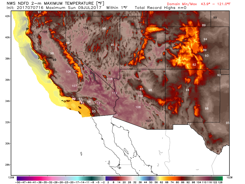
Extended Forecast for Phoenix, AZ
Temperatures in the Southwest are still quite hot, but the heat will start to break a bit as we head into the next few days. Here is the extended temperature outlook for Phoenix, AZ, which shows temperatures settling back down to near average levels, which is around 107F for this time of the year... WHEW!
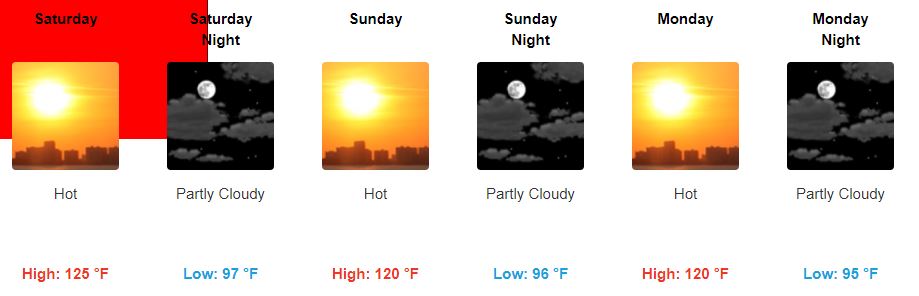
Death Valley, CA
Hot enough for ya? Take a look at the temperature forecast for Furnace Creek, CA (Death Valley), which suggests temperatures around 125F on Saturday and falling to a balmy 120F on Sunday and Monday. Note that "Death Valley's Furnace Creek holds the record for the highest reliably recorded air temperature in the world, 134 °F (56.7 °C) on July 10, 1913." WOW!
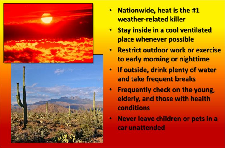
Heat is the #1 Weather Related Killer in the U.S.
"Nationwide, heat is the #1 weather-related killer. Stay inside in a cool ventilated place whenever possible. Restrict outdoor work or exercise to early morning or nighttime. If outside, drink plenty of water and take frequent breaks. Frequently check on the young, elderly, and those with health conditions. Never leave children or pets in a car unattended."
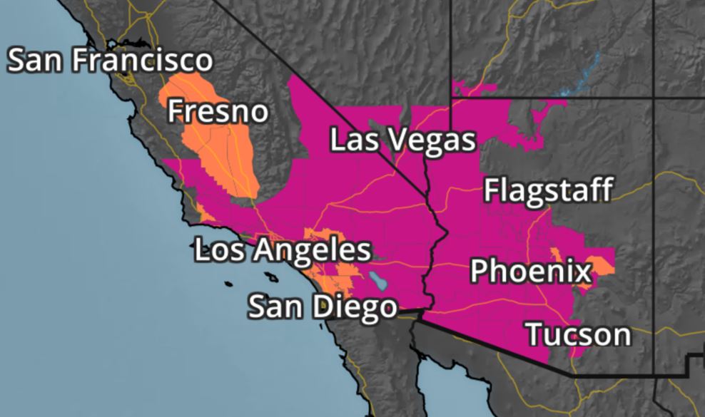
Excessive Heat Builds Again
The National Weather Service continues excessive heat advisories and warnings across the Southwest through Saturday with temperatures approaching 120F for some! Yea, that's hot...

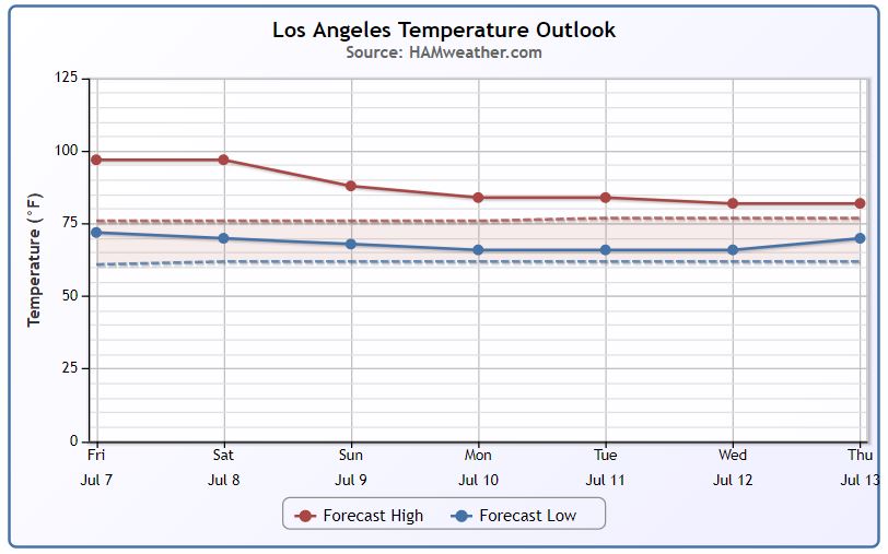
Hot In Los Angeles, CA Too!!
It's even hot in Los Angeles, CA!! Take a look at the extended outlook through the middle part of next week, which shows temperatures on Saturday still near 100F before cooling a bit Sunday and into the 2nd week of July. Note that a Heat Advisory continues in Los Angeles through 9PM Saturday for temperatures that could be as hot as 102F! Stay cool folks...
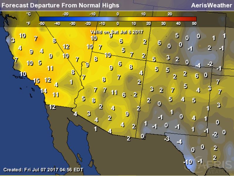
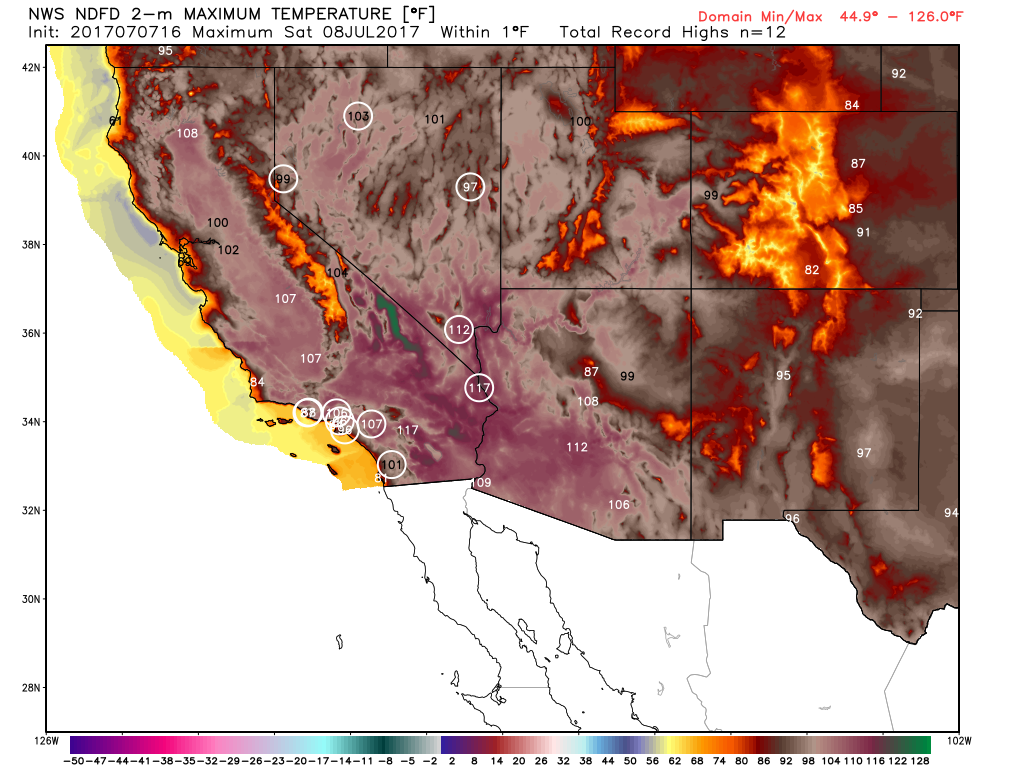
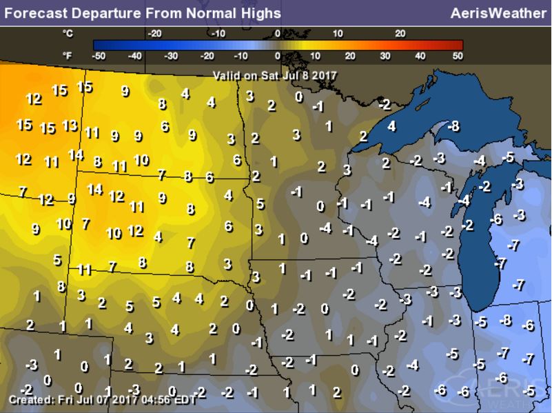
Saturday: High Temperatures, Highs Above Average & Records
Saturday appears to be the last 'extremely' hot day in a string of days that has brought widespread record high temperatures to the area. Note that many locations will still be a good 10F to 15F+ above average with several record highs possible again!
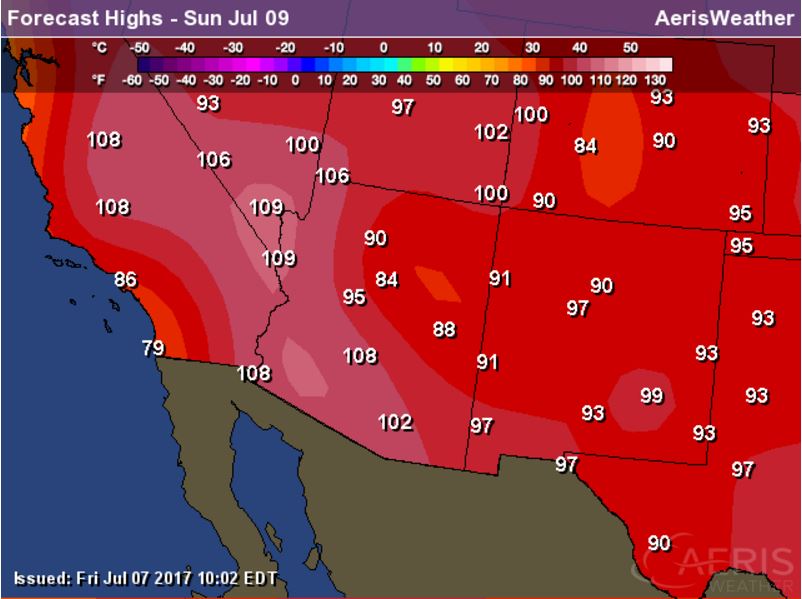
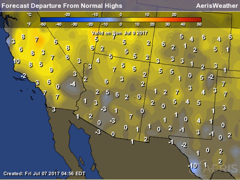
Sunday: High Temperatures, Highs Above Average & Records
Sunday will still be another hot day, no question. Temperatures will still be a good 5F to near 10F above average, but the heat will definitely be subsiding. Despite maybe a few isolated record highs in a few areas, much of the widespread record high territory will have faded.
_______________________________________________________________________
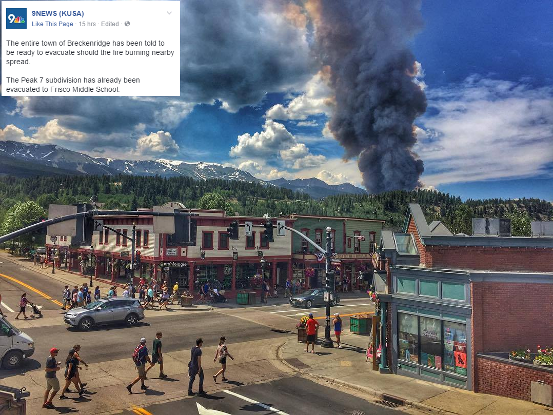
Fire in Breckenridge, CO
WOW! Take a look at this photo from 9NEWS (KUSA) Facebook page showing the fire that broke out in Breckenridge, CO on Wednesday... Here's a snippet from their website with updates on the fire:
Officials in Summit County said the Peak 2 Fire is expected to flare up again Thursday afternoon. The 84-acre fire started burning Wednesday morning near Breckenridge. So far, 463 homes have been evacuated from the Peak 7 subdivision and the entire town of Breckenridge is on alert for a potential evacuation order - especially if the fire spreads. Thankfully, a wind shift changed the direction of the fire from Breckenridge. The wildfire sent a large plume of smoke into the air between Breckenridge and Frisco, with visible flames. As of 9:15 p.m. Wednesday, no structures have been damaged.
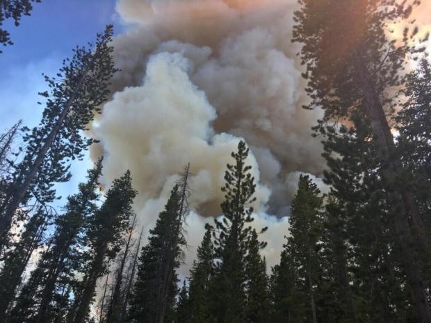
The Peak 2 Fire
According to Inciweb, this has been dubbed the Peak 2 Fire, which is located 2 miles north of the Breckenridge Ski Resort. Here's more from Inciweb: "The Peak 2 fire is burning in the Miner's Creek drainage between Frisco and Breckenridge, two miles north of the Breckenridge ski area, in dense lodgepole and dead/down beetle killed pine. The Multi Mission Aircraft (MMA) flight mapped the fire at 85 acres as of 3 p.m. Thursday, July 5 and is only 7% contained."
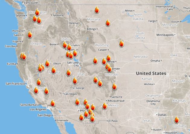
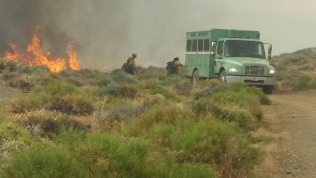
Ongoing Large Wildfires
Here's a look at the current wildfires across the Western US. The recent hot weather has allowed tinder dry conditions to develop, which has led to several wildfires popping up
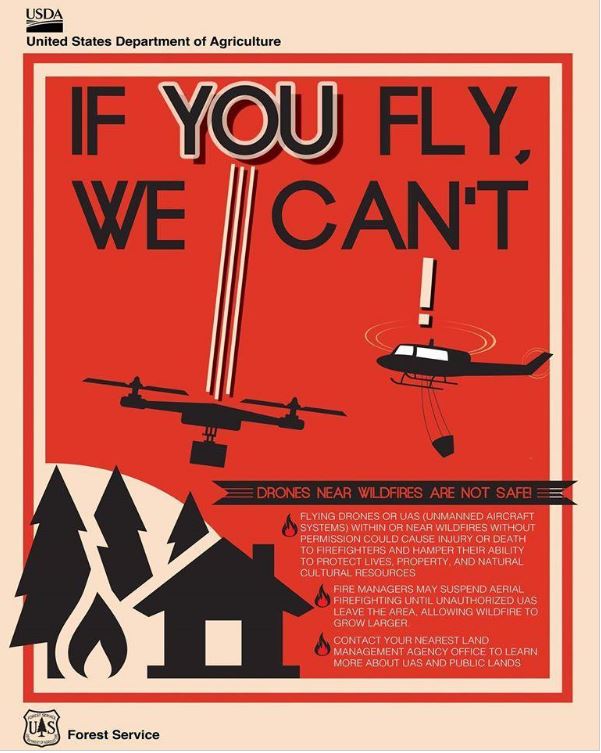
Here's an interesting story regarding drones causing air support to be grounded during wildfires! Here's the latest from Fox 31 in Denver (KDVR): "Fire departments statewide are pleading with the public to follow the rules when it comes to drones around active wildfires. Flying high above the ground, drones give a bird’s-eye view of the world. From cityscapes to places off-limits to the public, they can soar into fires like never before. “We certainly see the benefit in fact South Metro is seeing a few people to get properly trained,” South Metro Fire Rescue spokesman Eric Hurst said. However, sometimes drones can also be a hazard for fire crews. On Saturday, South Metro was one of four agencies responding to a grass fire in Sedalia. The 18-acre fire required air support but couldn’t utilize it as planned. “During [Saturday’s] incident, one of our fire crews observed a drone flying around the scene, so that triggers a lot of concerns for us,” Hurst said. A drone in the immediate area of a wildfire makes conditions too unsafe for airplanes. If the two collide, it could cause the plane to crash. “The pilots don’t want to be up in the air when they can’t communicate with another aircraft that’s flying next to them,” Hurst said. A similar situation happened at the Lightner Creek Fire in Durango last week. Planes carrying fire retardant were forced to drop their loads early and leave the area because of an unauthorized drone in the flight path. “We don’t want any kind of an accident to happen so at that point, aircraft is going to have to be grounded until we can find out who’s operating the drone and we can get them to stop,” Hurst said."
Truckee Fire - Located 10 Miles NW of Fernley, NV
According to Inciweb, one of the largest fires currently burning is located 10 miles NW of Fernley, NV. There are nearly 158 people working on a fire that has consumed more than 83,000 acres since Monday, July 3rd. The fire is 35% contained and the cause is unknown at this point. Here was the latest weather report: "Above normal temperatures nearing 100 degrees along with single digit humidity. Dry lightning and gusty outflow winds forecast."
 ________________________________________________________________________
Nearly perfect Saturday. More unsettled on Sunday
By Todd Nelson, filling in for Douglas
By Todd Nelson, filling in for Douglas
As a gardener, you tend to face lots of issues; plenty of curveballs from Mother Nature. Weather plays a big role on how your summer bounty will turn out, but animals and birds can also have a big impact on that too! With strawberries and raspberries coming in like gang busters, it's a race every morning to see who can get to the garden first.
Hey birds, SHOO! Man, my neighbors must think I am nuts.
Saturday will be just about as perfect as any July day could get around here. Plentiful sunshine, mild temperatures and low humidity calls for a dip in a nearby lake or pool. You won't regret it.
A fast moving clipper arrives Sunday with spotty showers and storms popping up during the afternoon. Some of the storms could get a little aggressive. You may also notice a slight bump in humidity values, but it won't be too sweaty.
There could be a few thundery downpours into early next week. Some models suggests nearly 1 to 2 inches of rain across parts of southern Minnesota. Good old fashioned muggy weather returns late next week.
______________________________________________________
______________________________________________________
Extended Forecast
SATURDAY: Nearly perfect. Enjoy! Winds: WNW 5-10. High: 83
SATURDAY NIGHT: Mostly clear and quiet. Winds: W 5. Low: 65.
SUNDAY: A bit muggy. Chance of thundershowers. Winds: SE 5. High: 83
MONDAY: A few leftover rumbles possible across southern MN. Winds: E 5. Wake-up: 66. High: 82
TUESDAY:Sticky sun. Storms return overnight. Winds: SE 5. Wake-up: 66. High: 86.
WEDNESDAY: Steamy Spotty late day storms. Winds: W 5-10. Wake-up: 70. High: 88.
THURSDAY: Mostly sunny. Looking dry. Winds: SE 5. Wake-up: 69. High: 85.
FRIDAY: Unsettled. Scattered storms possible. Winds: S 5. Wake-up: 66. High: 80.
_______________________________________________________
_______________________________________________________
This Day in Weather History
July 8th
July 8th
2002: A three-day deluge ends in central Minnesota with 10 inches in northern Kanabec county and 9.5 inches in southwest Aitkin County.
1974: Minnesota experiences an intense heat wave, with the Twin Cities reaching 101, the warmest temperature in 26 years.
________________________________________________________
________________________________________________________
Average High/Low for Minneapolis
July 8th
July 8th
Average High: 84F (Record: 101F set in 1974)
Average Low: 64F (Record: 51F set in 1958)
Average Low: 64F (Record: 51F set in 1958)
Record Rainfall: 3.07" set in 1925
_________________________________________________________
_________________________________________________________
Sunrise/Sunset Times for Minneapolis
July 7th
July 7th
Sunrise: 5:35am
Sunset: 9:00pm
Sunset: 9:00pm
Hours of Daylight: 15hours & 27mins
Daylight LOST since yesterday: ~1 minute and 12 seconds
Daylight LOST since summer solstice (June 20th): ~11 minutes
__________________________________________________________
Daylight LOST since summer solstice (June 20th): ~11 minutes
__________________________________________________________
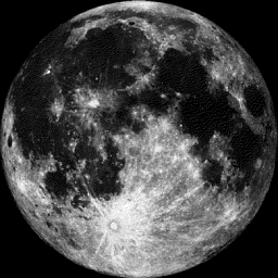
Moon Phase for July 7th at Midnight
0.9 Days Until Full "Buck" Moon
0.9 Days Until Full "Buck" Moon
July 9, 12:07 a.m. EDT – Full Buck Moon. This moon appears during the time when the new antlers of buck deer push out from their foreheads in coatings of velvety fur. It was also often called the Full Thunder Moon since thunderstorms are most frequent during this time. Sometimes it's also called the Full Hay Moon. Source: Space.com
_________________________
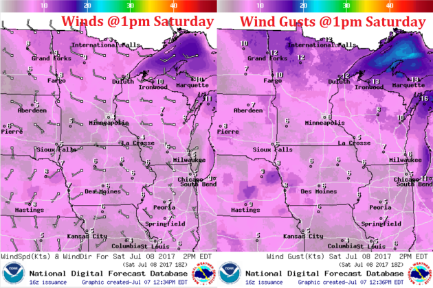
Weather Outlook For Saturday
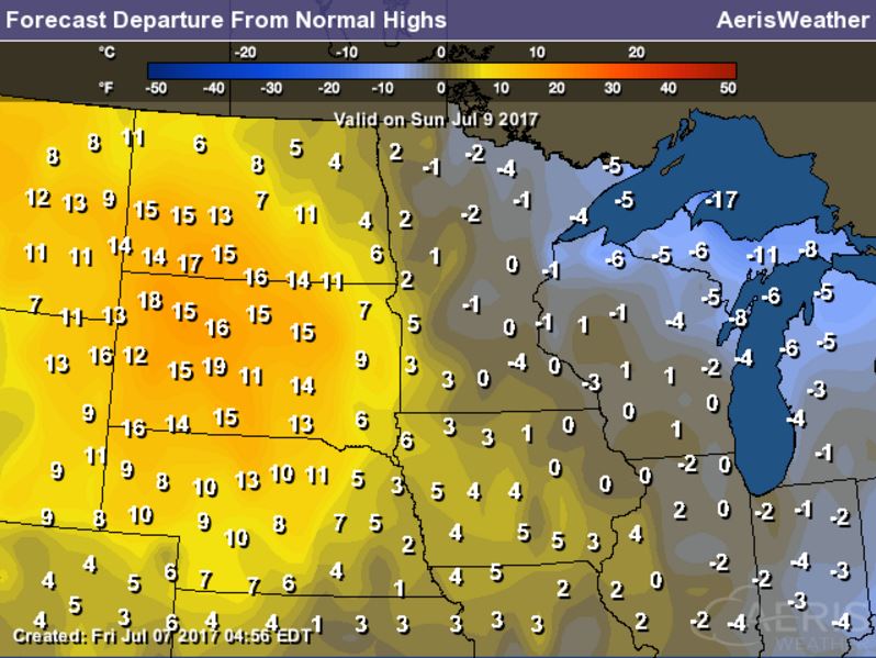
Saturday looks like another incredible day with plentiful sunshine, mild temperatures and low humidity values. The image(s) below shows near average high temperatures with mostly sunny skies across the region for Saturday. Enjoy!!
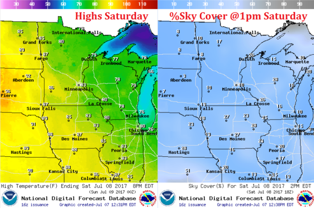
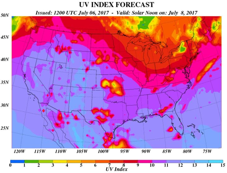
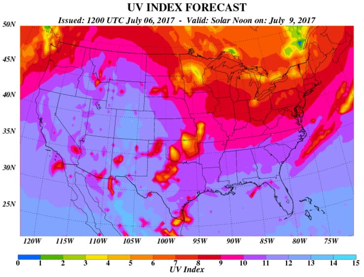
UV Index for Saturday - VERY HIGH
The UV Index will be considered VERY HIGH across much of the state of Minnesota on Saturday, which means that it will only 15 to 20 minutes or less to burn unprotected skin. With that said, if you are planning on spending any extended length of time outside, make sure you wear appropriate attire and lather on the sun block!
Weather Outlook for Saturday
Winds will not be an issue on Saturday and will continue to blow out of the west, which will help to keep humidity values in the comfortable zone.
__________________________________________________________________________
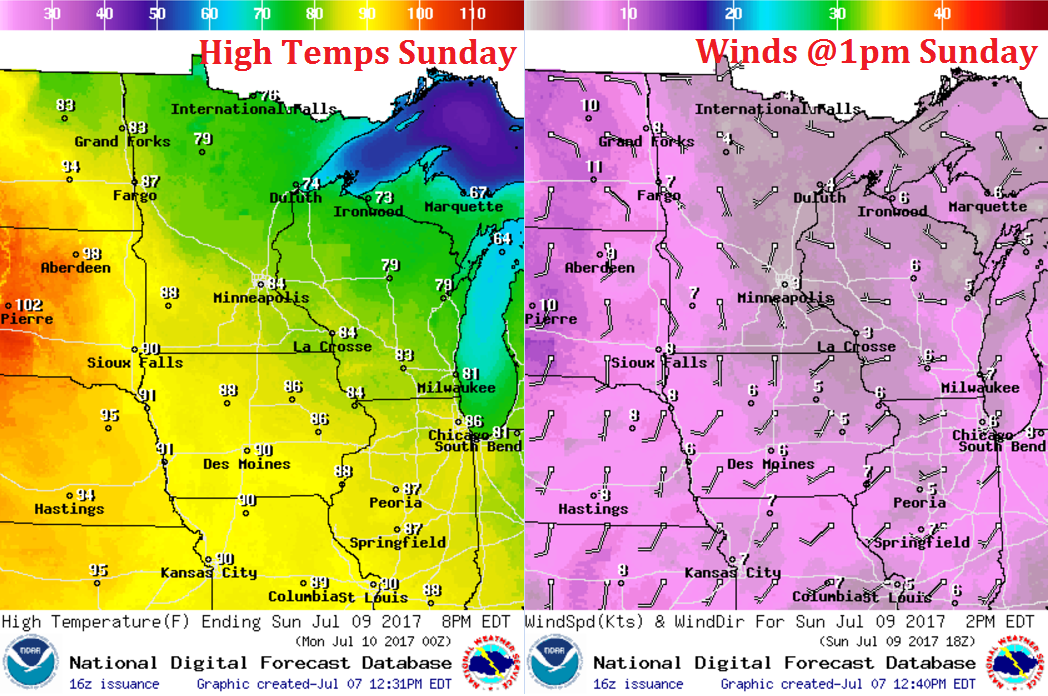
Weather Outlook For Sunday
Sunday will be a bit muggier than Friday and Saturday were. Temperatures will also be a bit warmer, which will make it feel, perhaps, a little too warm/humid for some. Note that winds will switch to the south, which will help to bring in a little more humidity.
UV Index for Sunday - HIGH
Despite dealing with a little more cloud cover, the UV Index will be considered HIGH across much of the state of Minnesota on Sunday, which means that it will only 20 to 30 minutes or less to burn unprotected skin. With that said, if you are planning on spending any extended length of time outside, make sure you wear appropriate attire and lather on the sun block!
_____________________________________________________________
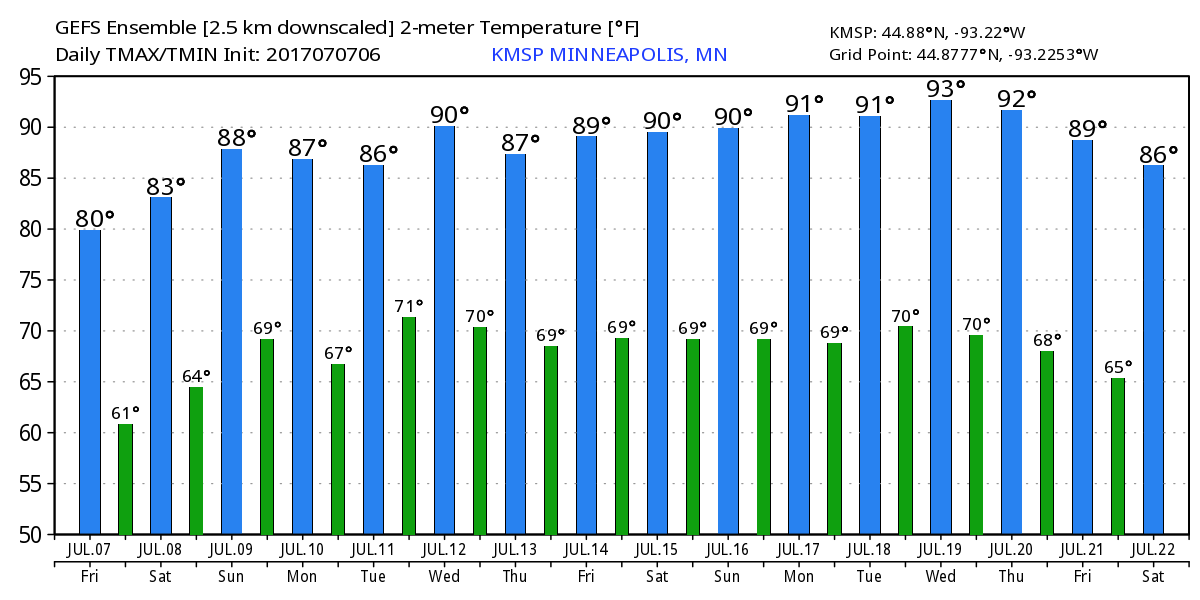
Temperature Outlook
Here's the temperature outlook through July 22nd, which shows comfortable temperatures hanging around through Saturday, but there does appear to be a trend towards hotter and stickier weather moving in next week, which could stick around through the 3rd full week of July! We could be dealing with several days around 90F with elevated dewpoints... Summertime in Minnesota.
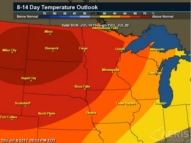
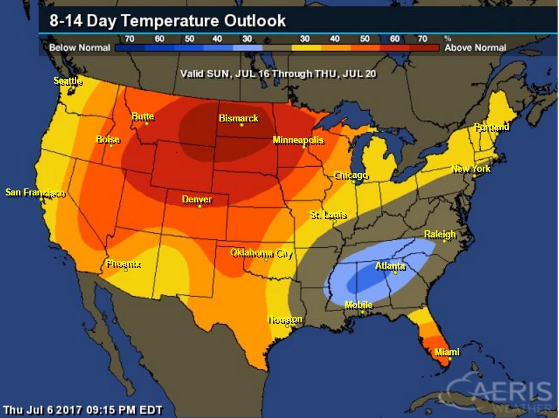
8 to 14 Day Temperature Outlook
According to NOAA's CPC, the extended temperature outlook from July 16th to July 20th suggests warmer than average temperatures moving back into the Upper Midwest. The middle part of the month could be quite steamy. Stay tuned...
___________________________________________________________
Extended Temperature Outlook
According to NOAA's CPC, the extended temperature outlook through July 20th shows much of the nation will be dealing with above normal temperatures around mid July. The only cool spot maybe located across parts of the Gulf Coast States and Tennessee Valley.
____________________________________________________________
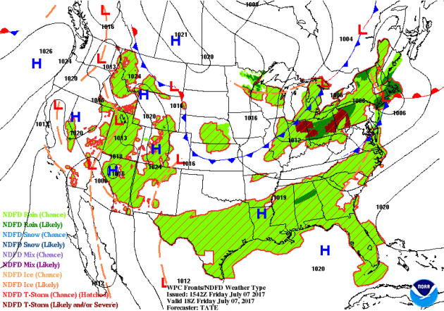
Weather Outlook This Week
The weather outlook over the next couple of days shows stormy weather continuing in the Northeastern US through the early weekend. Meanwhile, spotty showers and storms look to continue across the Gulf Coast States and across the Intermountain West and Desert Southwest through the weekend. Some locations could see isolated severe weather as well as locally heavy rainfall.
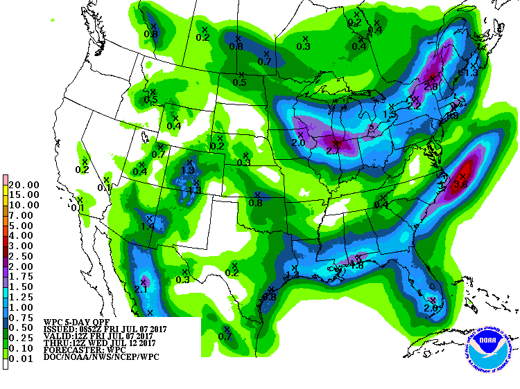
5 Day Precipitation Outlook
According to NOAA's WPC, the next several days could produce areas of locally heavy rainfall across parts of the Northeastern US and across the Gulf Coast States. There could also be a batch of heavy rain moving back into the Upper Midwest/Great Lakes/Ohio Valley late weekend and early next week with some 1" to 2"+ rainfall tallies possible. Also note that pockets of heavy rains could be found in the Southwest thanks to monsoonal thunderstorms.
___________________________________________________________________
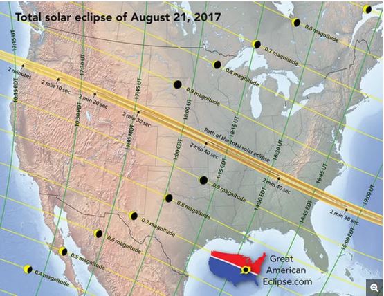
"Get Ready for Major Traffic Jams During the 2017 Solar Eclipse"
"With just about two months to go before the Aug. 21 total solar eclipse, one big question is: Just how many people intend to travel into the path of totality, which stretches from Oregon to South Carolina? "Imagine 20 Woodstock festivals occurring simultaneously across the nation," said Michael Zeiler, an eclipse cartographer who estimates conservatively that between 1.85 million and 7.4 million people may commute into the path. But unlike a concert, there are no ticket sales for the eclipse, so no one has a definitive count of how many people will attend. The only thing experts can do is speculate. Unfortunately, there is no recent precedent on which to base that speculation. It has been nearly 40 years since the last total solar eclipse passed over any part of the contiguous United States. On that occasion — Feb. 26, 1979 — the moon's umbral shadow passed over just five states in the Pacific Northwest and Northern Plains."
(The total solar eclipse of Aug. 21, 2017, will be an incredible celestial sight, and a traffic nightmare. Anyone planning to commute into the path should plan extra time. This map, created by eclipse cartographer Michael Zeiler, shows the progress of the moon's shadow.
Credit: Michael Zeiler/GreatAmericanEclipse.com, used with permissionThe total solar eclipse of Aug. 21, 2017, will be an incredible celestial sight, and a traffic nightmare. Anyone planning to commute into the path should plan extra time. This map, created by eclipse cartographer Michael Zeiler, shows the progress of the moon's shadow. Credit: Michael Zeiler/GreatAmericanEclipse.com, used with permission via Space.com)
Credit: Michael Zeiler/GreatAmericanEclipse.com, used with permissionThe total solar eclipse of Aug. 21, 2017, will be an incredible celestial sight, and a traffic nightmare. Anyone planning to commute into the path should plan extra time. This map, created by eclipse cartographer Michael Zeiler, shows the progress of the moon's shadow. Credit: Michael Zeiler/GreatAmericanEclipse.com, used with permission via Space.com)
________________________________________________________________________
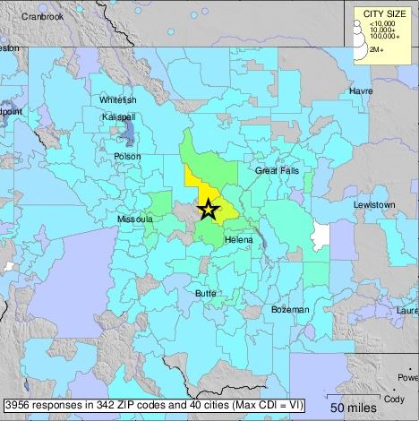
5.8 Magnitude Earthquake: Lincoln, Montana
According to the USGS, there was a 5.8 magnitude earthquake near Lincoln, Montana on Wednesday night. Here's more from the USGS: The July 6, 2017 M 5.8 earthquake southeast of Lincoln in western Montana occurred as the result of shallow strike slip faulting along either a right-lateral, near vertical fault trending east-southeast, or on a left-lateral vertical fault striking north-northeast. The location and focal mechanism solution of this earthquake are consistent with right-lateral faulting in association with faults of the Lewis and Clark line, a prominent zone of strike-slip, dip slip and oblique slip faulting trending east-southeast from northern Idaho to east of Helena, Montana, southeast of this earthquake. The Lewis and Clark line is a broad zone of faulting about 400 km in length, and up to 80 km wide (wider to the east). Faults within this zone, primarily of Middle Proterozoic to Holocene in age, can be traced as much as 250 km along strike, and typically change in strike from east (near Idaho) to southeast (near Helena). In the region of the July 6th earthquake, prominent faults include the St Mary’s-Helena Valley fault, and the Bald Butte fault, both right-lateral structures. More detailed field studies will be required to identify the causative fault responsible for this earthquake. Western Montana and northwestern Wyoming have experienced at least 16 other M 5+ earthquakes within 300 km of the July 6, 2017 event over the preceding century. The largest was the August 1959 M 7.2 Hebgen Lake earthquake – the largest historic event in the intermountain region – which occurred about 280 km to the south-southeast of the July 6th event. The Hebgen Lake earthquake triggered a large landslide that resulted in significant damage and more than 28 fatalities. A M 6.9 earthquake just over 100 km to the southeast of the July 6th earthquake in June, 1925, caused significant damage, but no fatalities. A M 5.6 earthquake occurred 170 km to the south of the July 6th event in July 2005, and caused minor damage in the surrounding region.
See more from the USGS HERE:
___________________________________________________________________________
See more from the USGS HERE:
___________________________________________________________________________
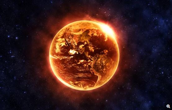
"Stephen Hawking: Earth Could Turn Into Hothouse Planet Like Venus"
"Earth could turn into a hothouse planet like Venus, with boiling oceans and acid rain, if humans don't curb irreversible climate change, physicist Stephen Hawking claimed in a recent interview. "We are close to the tipping point, where global warming becomes irreversible. Trump's action could push the Earth over the brink, to become like Venus, with a temperature of 250 degrees [Celsius], and raining sulfuric acid," he told BBC News, referring to the president's decision to pull the U.S. out of the Paris climate deal. But most climate experts say that scenario is a dramatic and implausible exaggeration: Relative to Venus, planet Earth is much farther from the sun and given its chemical makeup will never have such a thick carbon dioxide atmosphere, so it could not likely reach temperatures of 482 degrees Fahrenheit (250 degrees C) that Hawking described in the interview, they say."
(Image Credit: Aphelleon/Shutterstock via LiveScience)
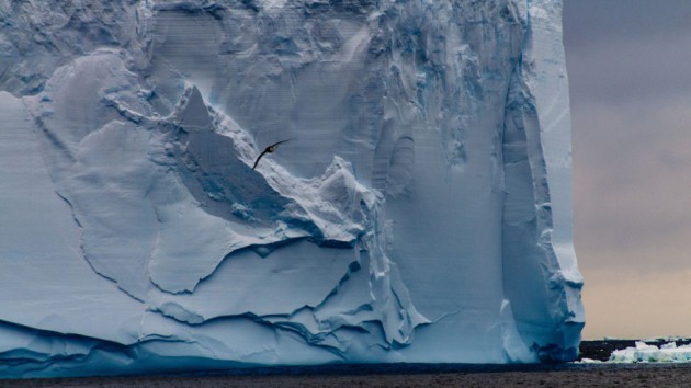
"Impending Antarctic iceberg is the size of Delaware, and extends 700 feet below the surface"
"Any way you look at it, we're about to witness the birth of one massive iceberg. Researchers with the European Space Agency (ESA) have taken more detailed measurements of the massive iceberg set to cleave off the Larsen C Ice Shelf at any minute. According to data from instruments aboard the CryoSat and Sentinel-1 satellites, the iceberg will be one of the largest on record since at least the early 1990s, when satellite-based monitoring began in this region. The iceberg is expected to be about 6,600 square kilometers, or about 2,500 square miles, in area. Using a radar altimeter aboard the Cryosat satellite, scientists have measured the height of the ice surface, which they used to calculate the thickness of the ice and its volume. Noel Gourmelen from the University of Edinburgh said the iceberg is likely to be about 190 meters, or about 620 feet, thick, and contain about 1,155 cubic kilometers, or about 277 cubic miles, of ice."
(Image Credit: SHUTTERSTOCK / DURK TALSMA via Mashable)
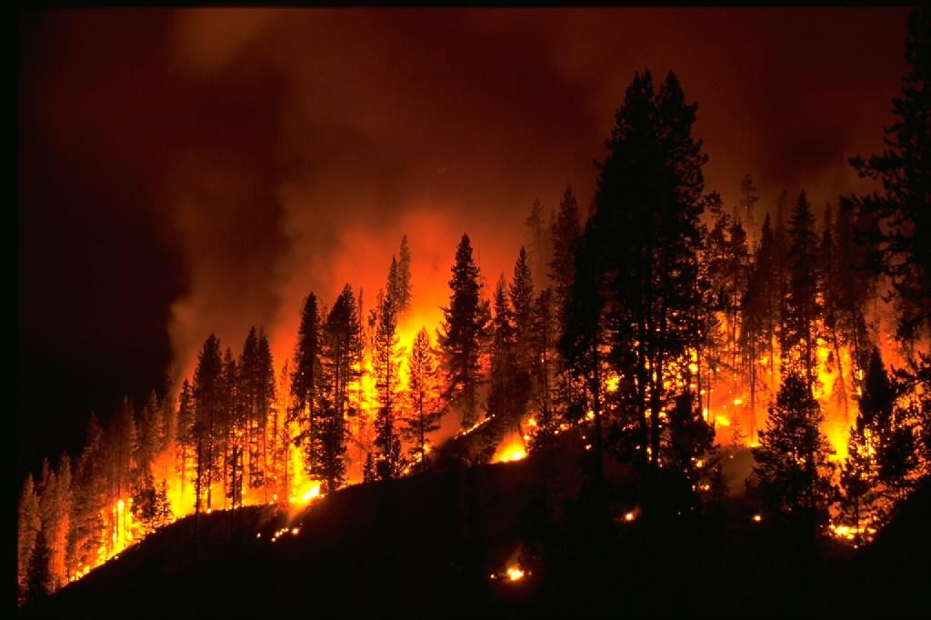
"Climate change expected to fuel larger forest fires — if it hasn't already"
"Global warming will likely heighten the risk of large, more difficult to control wildfires scorching the western United States. It’s the main conclusion of a body of science that, over the years, has increasingly drawn connections in the West between the prevalence of major blazes and the rising frequency of earlier springtime conditions followed by hotter and drier summers. “Climate absolutely affects fire because it affects how flammable the fuels are,” said LeRoy Westerling, a professor at UC Merced who has been studying climate and wildfires for the past 15 years. “Your drought years are going to be more extreme because it’s warmer during the drought years, so you have more evaporation, and those preceding years that were wetter are retaining less water,” added Westerling, who has worked on these issues with colleagues at places like UC San Diego’s Scripps Institution of Oceanography in La Jolla."
(Image Credit: NOAA)
______________________________________________________________
Thanks for checking in and don't forget to follow me on Twitter @TNelsonWX

No comments:
Post a Comment