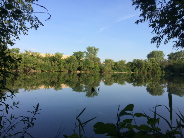
Summer Scenes
It's hard not to like the Minnesota Summers. Lakes, trees and brilliant blue sky. Unfortunately, our summers are short-lived, so make the most of them while you can! It's crazy to think that in 6 weeks, we will be stuffing our face with everything on a stick at the Great Minnesota Get-Together... Sigh
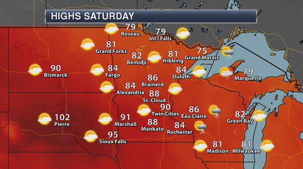
Severe Threat Saturday
After a much cooler, less humid and quieter day across the region Thursday, weather conditions will once again be heating up and turning more unsettled as we approach the weekend. According to NOAA's SPC, there is a risk for isolated strong storms across parts of northwestern MN on Friday and a risk of isolated strong to severe storms across parts of eastern and especially southeastern Minnesota on Saturday. Stay tuned for more...
.png)
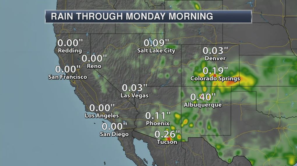
Simulated Radar
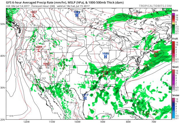
The simulated radar from AM Saturday to midday Sunday quiet weather to start our Saturday, but a few late-day storms could pop along and east of the Minnesota/Wisconsin border. Some of these storms could be strong to severe with brief heavy downpours. After Saturday's late day thunder threat, weather conditions look quite sublime for Sunday. Enjoy!
.gif)
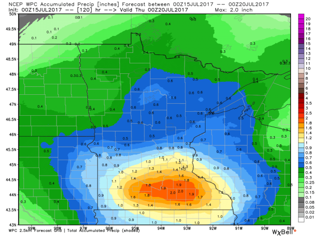
The extended forecast through Wednesday suggests heavier rain potential across southern Minnesota with the potential of 1" to 2". The first batch of heavier rain looks like it could rumble in Monday night. Stay tuned...
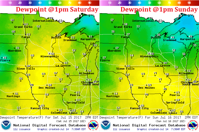
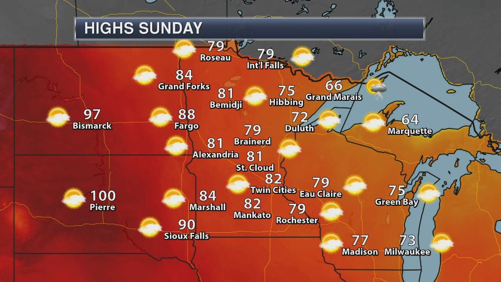
Sticky Saturday, Somewhat Sublime Sunday
A quick moving storm system will push through the region this weekend, which will allow hot and sticky weather to return on Saturday. Dewpoints will approach 70F for some across the southern part of the state, which will feel almost tropical at times. The storm system will also kick out a few late-day rumbles along and east of the Minnesota/Wisconsin border, some of which could be a little strong/severe. As the system moves east of us, cooler and slightly less humid conditions will move in on Sunday. At this point, Sunday looks like a very nice, comfortable mid-July day. Enjoy!
___________________________________________________________________________
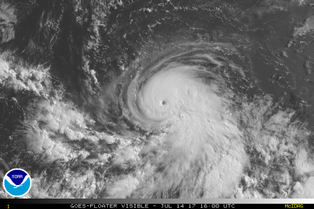
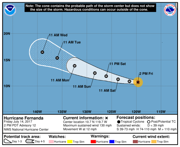
FERNANDA in the Eastern Pacific
The National Hurricane Center continues to track FERNANDA, which as of late Friday was a category 4 hurricane with 130mph sustained winds. FERNANDA is the 6th named storm of the 2017 Eastern Pacific Hurricane Season and the 3rd hurricane of the season behind DORA & EUGENE, but is the first major hurricane of the season.
.gif)
Here's the official track for FERNANDA, which has it staying a major hurricane through early next week. The good news is that the forecast track has it continuing to drift west away from any major landmass.
Here's an interesting image. This is the forecast from a number of different models regarding the potential strength of FERNANDA over time. Note that one model has this storm potentially reaching category 5 strength before diminishing over the next 3 to 5 days.
.png)
Eastern Pacific Outlook: Next 5 Days
Weather conditions in the Eastern Pacific continue to remain active as NOAA's NHC is keeping an eye on two other waves of energy east of FERNANDA one has a medium chance of tropical development over the next 5 days, while the other has a low chance. Stay tuned...
.png)
Atlantic Outlook: Next 5 Days
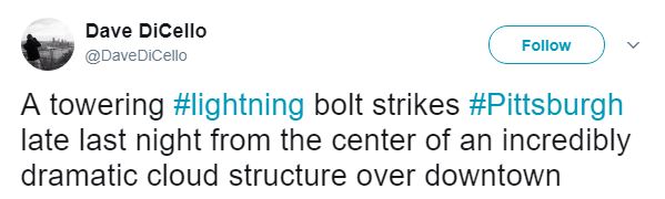
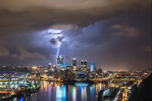
WOW! Look at this picture from @DaveDiCello who is a talented cityscape & wedding photographer from Pittsburgh, PA. This picture was snapped Thursday night as storms rumbled over the city. Great shot Dave!
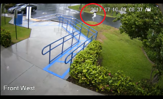
The Broward County Sheriff’s Office is reporting a swim instructor and lifeguard was jolted by a lightning strike that hit a nearby concrete pole Monday morning. According to sheriff spokesman Mike Jachles, the 27-year-old woman was about 300 feet from the pole when the lightning struck. She was taken to Florida Medical Center where she was treated and released.
See the video from PalmBeachPost.com HERE:
 _______________________________________________________________________2017 Lightning Fatalities
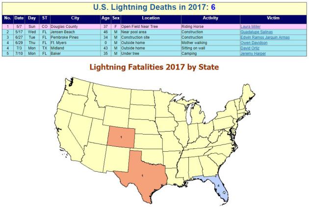
According to NOAA's NWS, there have been 6 lightning fatalities so far this year. Note that 4 of those deaths have occurred in Florida, which is considered to be the lightning capital of the United States.
 Lightning Deaths Over the Last 10 Years
According to NOAA's NWS, lightning kills an average of 47 people each year in United States! Over the last 10 years, 310 people have died from lightning and what is interesting is that nearly 79% have been males!
Lightning Deaths Over the Last 10 Years
According to NOAA's NWS, lightning kills an average of 47 people each year in United States! Over the last 10 years, 310 people have died from lightning and what is interesting is that nearly 79% have been males!
.png) Lightning Safety: Myths & Facts
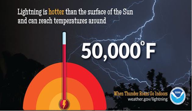
Did you know that lightning is nearly 5 times hotter than the surface of the sun? Here are a few interesting myths and facts from NOAA's NWS regarding lightning:
Lightning Safety: Myths & Facts
Did you know that lightning is nearly 5 times hotter than the surface of the sun? Here are a few interesting myths and facts from NOAA's NWS regarding lightning:
Myth: If you're caught outside during a thunderstorm, you should crouch down to reduce your risk of being struck.
Fact: Crouching doesn't make you any safer outdoors. Run to a substantial building or hard topped vehicle. If you are too far to run to one of these options, you have no good alternative. You are NOT safe anywhere outdoors. See our safety page for tips that may slightly reduce your risk.
Myth: Lightning never strikes the same place twice.
Fact: Lightning often strikes the same place repeatedly, especially if it's a tall, pointy, isolated object. The Empire State Building is hit an average of 23 times a year
Myth: If it’s not raining or there aren’t clouds overhead, you’re safe from lightning.
Fact: Lightning often strikes more than three miles from the center of the thunderstorm, far outside the rain or thunderstorm cloud. “Bolts from the blue” can strike 10-15 miles from the thunderstorm.
Myth: Rubber tires on a car protect you from lightning by insulating you from the ground.
Fact: Most cars are safe from lightning, but it is the metal roof and metal sides that protect you, NOT the rubber tires. Remember, convertibles, motorcycles, bicycles, open-shelled outdoor recreational vehicles and cars with fiberglass shells offer no protection from lightning. When lightning strikes a vehicle, it goes through the metal frame into the ground. Don't lean on doors during a thunderstorm.
Myth: A lightning victim is electrified. If you touch them, you’ll be electrocuted.
Fact: The human body does not store electricity. It is perfectly safe to touch a lightning victim to give them first aid. This is the most chilling of lightning Myths. Imagine if someone died because people were afraid to give CPR!
Myth: If outside in a thunderstorm, you should seek shelter under a tree to stay dry.
Fact: Being underneath a tree is the second leading cause of lightning casualties. Better to get wet than fried!
See more on lightning including safety tips HERE:
 ___________________________________________________________________________
National Weather Hazards Ahead...
See the video from PalmBeachPost.com HERE:
According to NOAA's NWS, there have been 6 lightning fatalities so far this year. Note that 4 of those deaths have occurred in Florida, which is considered to be the lightning capital of the United States.
Myth: If you're caught outside during a thunderstorm, you should crouch down to reduce your risk of being struck.
Fact: Crouching doesn't make you any safer outdoors. Run to a substantial building or hard topped vehicle. If you are too far to run to one of these options, you have no good alternative. You are NOT safe anywhere outdoors. See our safety page for tips that may slightly reduce your risk.
Myth: Lightning never strikes the same place twice.
Fact: Lightning often strikes the same place repeatedly, especially if it's a tall, pointy, isolated object. The Empire State Building is hit an average of 23 times a year
Myth: If it’s not raining or there aren’t clouds overhead, you’re safe from lightning.
Fact: Lightning often strikes more than three miles from the center of the thunderstorm, far outside the rain or thunderstorm cloud. “Bolts from the blue” can strike 10-15 miles from the thunderstorm.
Myth: Rubber tires on a car protect you from lightning by insulating you from the ground.
Fact: Most cars are safe from lightning, but it is the metal roof and metal sides that protect you, NOT the rubber tires. Remember, convertibles, motorcycles, bicycles, open-shelled outdoor recreational vehicles and cars with fiberglass shells offer no protection from lightning. When lightning strikes a vehicle, it goes through the metal frame into the ground. Don't lean on doors during a thunderstorm.
Myth: A lightning victim is electrified. If you touch them, you’ll be electrocuted.
Fact: The human body does not store electricity. It is perfectly safe to touch a lightning victim to give them first aid. This is the most chilling of lightning Myths. Imagine if someone died because people were afraid to give CPR!
Myth: If outside in a thunderstorm, you should seek shelter under a tree to stay dry.
Fact: Being underneath a tree is the second leading cause of lightning casualties. Better to get wet than fried!
See more on lightning including safety tips HERE:
PRELIMINARY 2017 Tornado Map
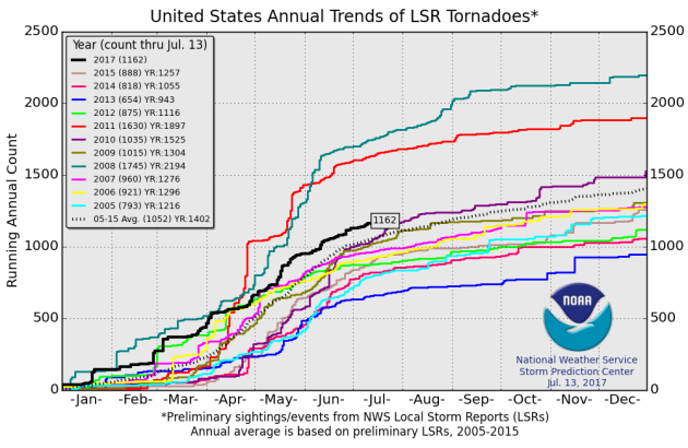
It certainly has been a fairly active first half of 2017 with 1162 preliminary tornado reports through July 13th. Note that this is the most tornadoes through July 11th since 2011, when there were nearly 1,600 reports. The map below shows the distribution of the tornadoes so far this year.
.gif) PRELIMINARY 2017 Tornado Count
PRELIMINARY 2017 Tornado Count
According to NOAA's SPC, the PRELIMINARY 2017 tornado count is 1162 (through July 13). Note that is the most active year for tornadoes since 2011, when there were 1,630 tornadoes. Keep in mind there was a major tornado outbreak in the Gulf Coast region from April 25-28, 2011 that spawned nearly 500 tornadoes, some of which were deadly. That outbreak is known as the Super Outbreak of 2011 and has gone down in history as one of the biggest, costliest and one of the deadliest tornado outbreaks in history.
____________________________________________________________
2.) Flooding possible across portions of the Southern Rockies, the Central Rockies, the Central Great Basin, and the Southwest.
3.) Flooding occurring or imminent across portions of the Middle Mississippi Valley, the Great Lakes, and the Ohio Valley.
4.) Flooding possible across portions of the Central Rockies, the Central Great Basin, and the Southwest.
5.) Excessive heat across portions of the Central Plains, the Northern Plains, the Tennessee Valley, the Mississippi Valley, the Great Lakes, and the Ohio Valley, Tue-Thu, Jul 18-Jul 20.
6.) Excessive heat across portions of the Southeast and the Mid-Atlantic, Thu-Fri, Jul 20-Jul 21.
7.) Much above normal temperatures across portions of the Central Plains, the Middle Mississippi Valley, the Upper Mississippi Valley, and the Northern Plains, Mon, Jul 17.
8.) Heavy rain across portions of mainland Alaska, Tue-Wed, Jul 18-Jul 19.
9.) Slight risk of much above normal temperatures for portions of the Central Great Basin, the Northern Plains, the Southern Plains, the Northern Rockies, California, the Northern Great Basin, and the Pacific Northwest, Wed-Fri, Jul 26-Jul 28.
10.) Slight risk of much above normal temperatures for portions of the Central Plains, the Northern Plains, the Middle Mississippi Valley, the Upper Mississippi Valley, the Great Lakes, and the Ohio Valley, Sat, Jul 22.
11.) Slight risk of much above normal temperatures for portions of the Southeast, Tue-Fri, Jul 25-Jul 28.
12.) Severe Drought across Hawaii, the Northern Plains, Southeastern California, and Southwestern Arizona.
.png)
_________________________________________________________
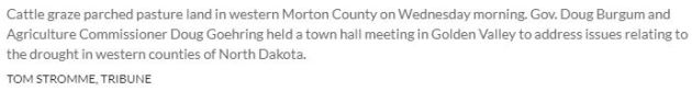
"Farmers, ranchers share concerns with Burgum, state officials"
It has been very hot and dry across the Dakotas over the last several weeks and that has many farmers concerned about their crops. Here's an excerpt from the Bismarck Tribune regarding hay concerns, which farmers are producing next to nothing this year:
"Nearly 100 farmers, ranchers and community members turned out Wednesday to talk with Gov. Doug Burgum and other state officials about the challenges posed by dry weather. They gathered in a public town hall in Golden Valley, located within a designated area of extreme drought in Mercer County in western North Dakota. Burgum was joined by North Dakota Agriculture Commissioner Doug Goehring, Maj. Gen. Alan Dohrmann of the North Dakota National Guard, Garland Eberle of the State Water Commission and State Forester Larry Kotchman. After months of abnormally low rainfall and dry conditions, struggling farmers and ranchers are looking for help. Burgum said Wednesday's town hall helped the state solicit ideas from the public."
____________________________________________________________________________
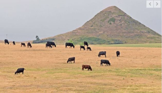
EXTREME Drought in North Dakota
According to the US Drought Monitor, nearly 36% of the state is considered to be in an EXTREME Drought. This is up from nearly 29% last week. Also, nearly 94% of the state is considered to be either abnormally dry or in some type of drought.
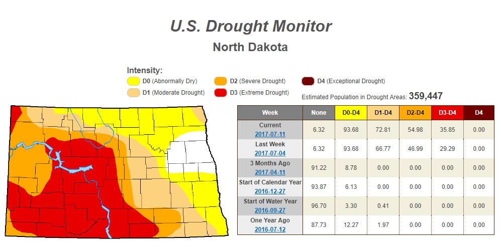
Rain Needed to End Drought
Extreme drought conditions are in place over parts of Montana and North and South Dakota due to several days/week of hot and dry weather. The image below suggests how much rain would be needed to end the drought, which suggests nearly 6" to 12" or more!
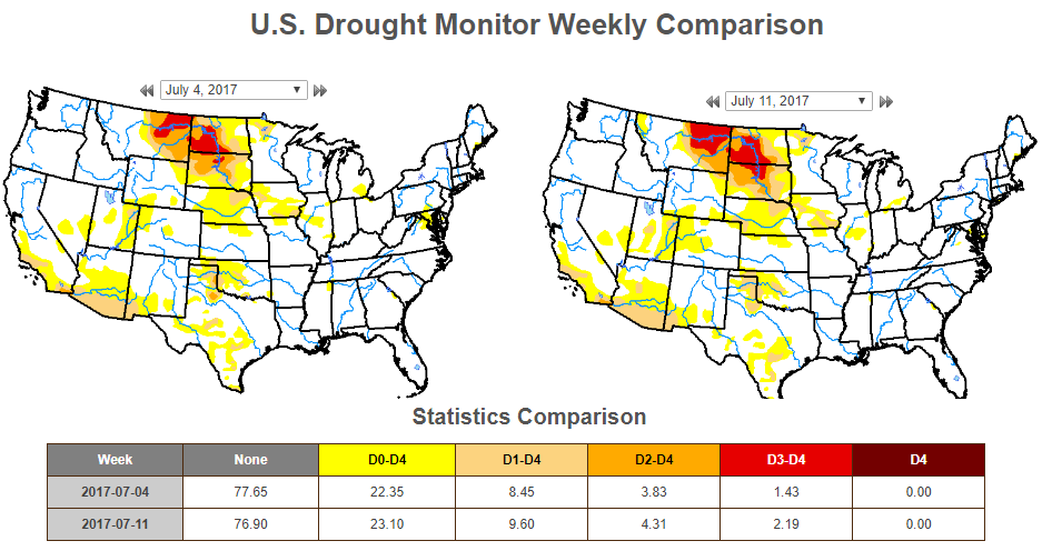
US Drought Monitor
According to the US Drought Monitor, drought conditions from July 4h to July 11th worsened slightly across the nation. Note that EXTREME drought conditions (located across parts of Montana and parts of North and South Dakota increased from 1.43% last week to 2.19% this week.
_________________________________________________________________________
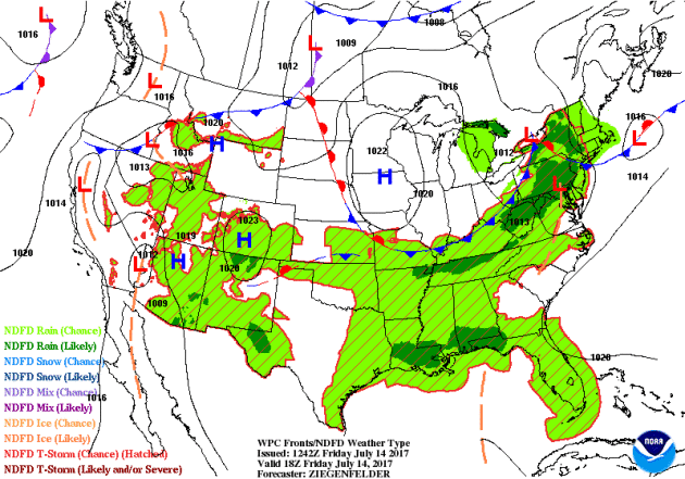
National Weather Outlook
Here's the weather outlook through the middle part of next week, which areas of showers and storms in the Gulf Coast and Mid-Atlantic Region this weekend with locally heavy rainfall and a few strong storms. Weather conditions also look a little unsettled across the Upper Midwest as we head into next week. There could be areas of severe storms and heavy rainfall developing on the outer periphery of the hot & sticky weather in the Central US. Meanwhile, monsoonal storms with locally heavy rains will continue across the Southwest.
Severe Threats Saturday & Sunday
Here are the severe weather concerns for Saturday and Sunday from NOAA's SPC. Note that a few isolated strong storms could be found in the Southwest and the Mid-Atlantic on Saturday, but the main concern will be found across the Western Great Lakes region with large hail and gusty winds being the primary concern late in the day. By Sunday, the threat shifts into the Eastern Great Lakes region with another threat moving back into the High Plains.
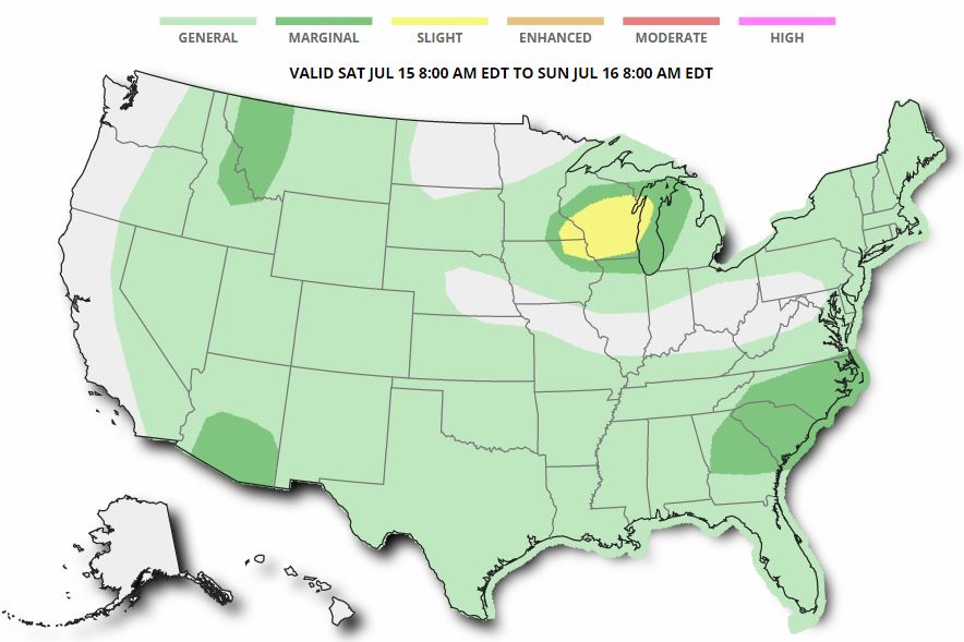
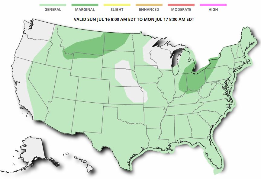
Excessive Rainfall Potential Saturday & Sunday
According to NOAA's WPC, there is a risk of excessive rain on Saturday mainly across parts of the Central Plains, but there may also be some heavy rains from the Lower Mississippi Valley to the Mid-Atlantic region and from monsoon storms in the Southwest. The threat for excessive rainfall exists in nearly the same areas on Sunday.
.gif)
.gif)
With excessive rainfall potential in place over parts of the Ohio Valley, Northeast and Mid-Atlantic on Friday and Saturday, some spots could see more than 1" to 2"+ of rain. This heavy rain threat could lead to isolated areas of flooding!
________________________________________________________
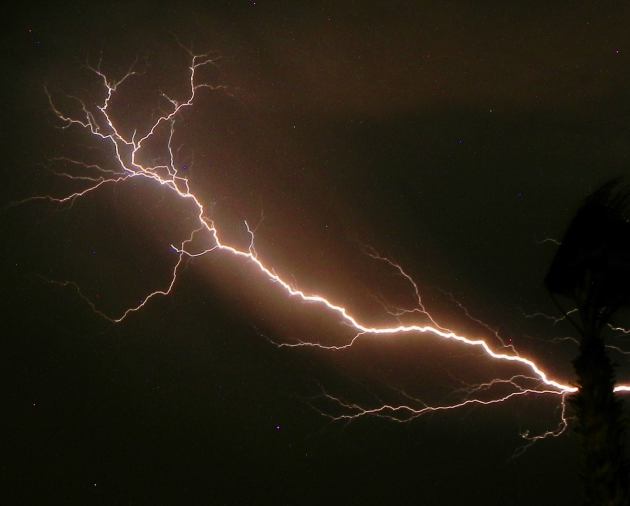
Monsoonal Storms
Thanks to my good friend Rich Koivisto from Bullhead City, AZ, who captured this impressive lightning strike during some monsoonal thunderstorms late last weekend! According to NOAA's NWS, the monsoon season was considered to have started when there were 3 three consecutive days of average dewpoint temperatures of 55 degrees or higher. That was the definition/protocol through the year 2007, but in 2008, the NWS decided to declare June 15th to September 30th the official monsoon season in Arizona. Pretty neat!
Monsoonal Storms Continue
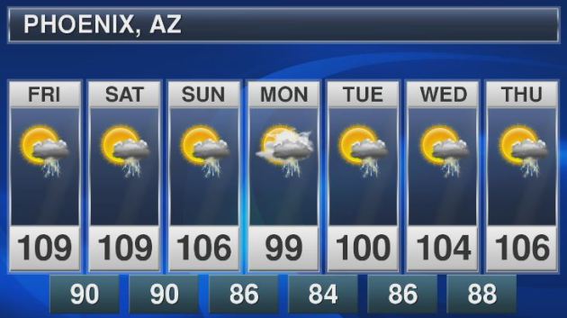
Sure it'll be hot in Phoenix, AZ over the next few days, but look at the cooling trend as we head into early next week. A high of 100F on Monday, wow... what a relief! Keep in mind that the average high in Phoenix at this time of the year is 107F. Also note the continued thunderstorm chances, these are daily monsoon thunderstorm chances that could bring heavy pockets of rain to localized areas through next week.
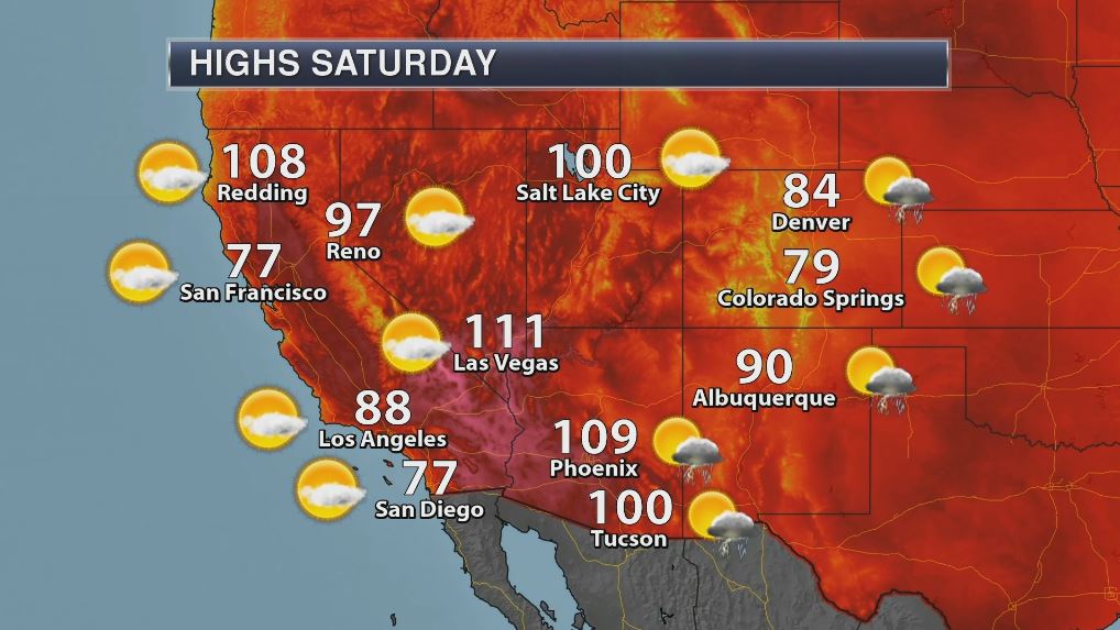
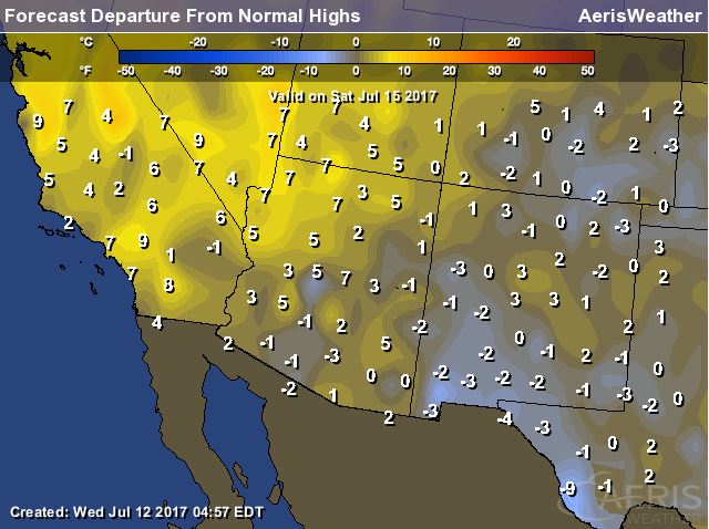
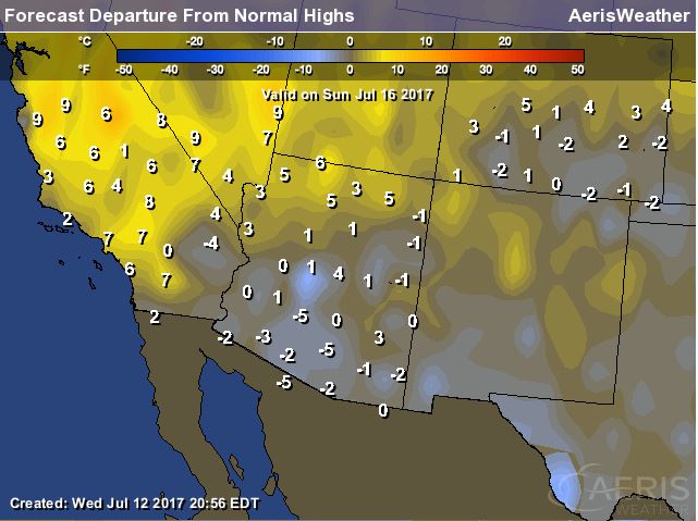
High Temperatures on Saturday
The heat will continue to build west of the Four Corners Region on Saturday with some locations nearly 10F above average. With this next surge of hot and dry weather building into the region, the fire danger threat is expected to increase as well.
Highs in the Southwest on Sunday
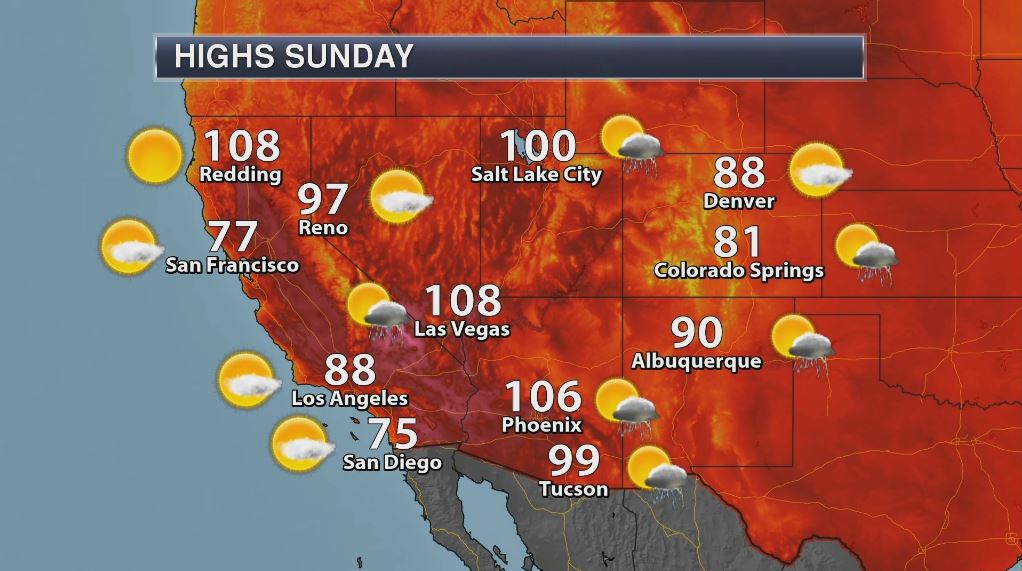
Sunday will be another hot day for interior locations across the Southwest with temperatures still running nearly 5F to 10F above average.
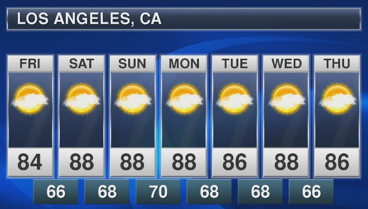
Los Angeles, CA
With temperatures on the upswing across parts of the Southwest through the end of the week and weekend ahead, places like Los Angeles, CA could once again see highs in the 90s! Here's the extended forecast through the middle part of next week, which shows near 90F highs from Saturday to Wednesday. WHEW!
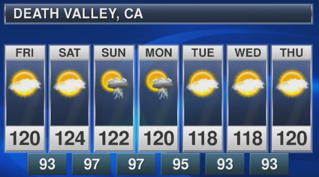
Death Valley, CA
High temperatures in Death Valley, CA will also be quite hot. Note that high temperatures will be around 120F or more through the middle of next week. There may even be a chance for an isolated monsoon storm Sunday and Monday.
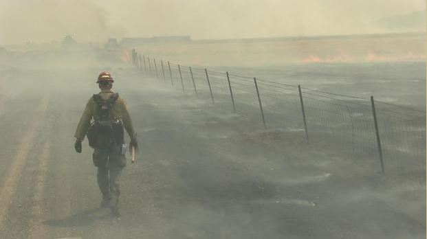
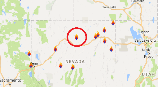
Rooster Comb Fire - Battle Mountain, Nevada
According to Inciweb, one of the largest fires currently burning in the Lower 48 is the Rooster Comb Fire located near Battle Mountain, NV. This particular fire has consumed a whopping 218,000 acres and is 71% contained. This particular fire started on Sunday, July 9th and quickly spread as hot, dry and windy weather created extreme fire behavior. Thunderstorms and erratic winds are still posing a concern for the fire. The good news is that there are currently 820 people working on the fire and the estimated containment date is projected for this weekend; Sunday, July 16th.
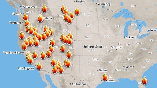
Ongoing Large Wildfires
Here's a look at the current wildfire map across the country. Recent hot and dry weather has helped to spark several wildfires across the Western US, while a few have also been popping up in the Eastern US.
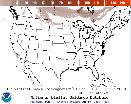
National Smoke Analysis
Here's the projected wildfire smoke concentration for midday Saturday, which suggests that smoke from wildfires burning across Canada could start to move into the extreme northern portions of the country this weekend. If you are in these areas, air quality could be quite poor, but these areas may also be enjoying very interesting looking sunrises/sunsets, which tend to look hazy or reddish-orange.
________________________________________________________________________
Sticky sun Saturday with a few late day rumbles
By Todd Nelson, filling in for Douglas
By Todd Nelson, filling in for Douglas
When it comes to summertime rain, it can be feast or famine. Radar estimated rainfall across the state suggests that some spots have had 2 to 4 inches of thundery downpours this month, while other haven't had a drop. The Twin Cities is nearly 1.5 inches below normal rainfall this month, but is still more than 0.5 inch above normal for the year.
According to the US Drought Monitor, 6 percent of northwestern Minnesota is dealing with moderate drought conditions, but extreme drought has developed for our friends in North and South Dakota. Intense heat combined with dry weather has baked the region for weeks. Farmers are having a hard time right now as hay production has been cut severely and it only looks to get worse.
Hot and soupy weather returns for us Saturday with a few spotty late-day rumbles. A few storms could get a little aggressive along and east of the MN/WI border with a brief heavy downpour. The front clears us Sunday, allowing cooler and less humid air to return. Sunday looks like a beautiful summer day!
______________________________________________________
______________________________________________________
Extended Forecast
SATURDAY: Hot & sticky. Spotty late day rumbles? Winds: WNW 5-10. High: Near 90.
SATURDAY NIGHT: Mostly clear and quiet. Winds: N 5. Low: 65.
SUNDAY: Beautiful. Not quite as humid. Winds: ESE 5. High: 82.
MONDAY: Heating up! Storms arrive overnight. Winds: S 5-10. Wake-up: 63. High: 87.
TUESDAY: Hot & sweaty. Lingering T-storms. Winds: E 5. Wake-up: 70. High: 87.
WEDNESDAY: Unsettled. Increasing PM thunder risk. Winds: ESE 5. Wake-up: 66 High: 83.
THURSDAY: Stray T-shower possible. Winds: ENE 5. Wake-up: 65. High: 83.
FRIDAY: Warm sun. Looks dry. Winds: S 5. Wake-up: 66. High: 87.
_______________________________________________________
_______________________________________________________
This Day in Weather History
July 15th
July 15th
1980: Straight-line winds of nearly 100 mph cause enormous damage, mainly in Dakota County. 43 million dollars in damage is reported and 100 thousand people lose power.
________________________________________________________
________________________________________________________
Average High/Low for Minneapolis
July 15th
July 15th
Average High: 84F (Record: 102F set in 1988)
Average Low: 64F (Record: 49F set in 1912)
Average Low: 64F (Record: 49F set in 1912)
Record Rainfall: 1.87" set in 1907
_________________________________________________________
_________________________________________________________
Sunrise/Sunset Times for Minneapolis
July 15th
July 15th
Sunrise: 5:41am
Sunset: 8:56pm
Sunset: 8:56pm
Hours of Daylight: 15hours & 15mins
Daylight LOST since yesterday: ~1 minute and 37 seconds
Daylight LOST since summer solstice (June 20th): ~22 minutes
__________________________________________________________
Daylight LOST since summer solstice (June 20th): ~22 minutes
__________________________________________________________
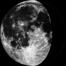
Moon Phase for July 15th at Midnight
0.5 Days Before Last Quarter
0.5 Days Before Last Quarter
_________________________
Weather Outlook For Saturday
Saturday will be a fairly hot and sticky day across the region, especially across the southern part of the state, where temperatures will warm to near 90F. That combined with dewpoints near 70F will make it feel even hotter. Spotty late-day storms may also be possible across the southeastern part of the state and into Wisconsin.

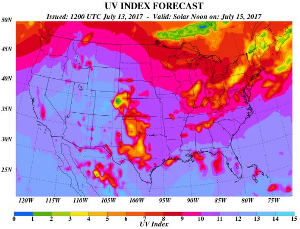
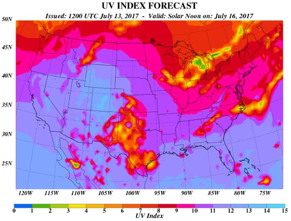
UV Index for Saturday - VERY HIGH
The UV Index will be considered VERY HIGH across much of the state of Minnesota on Friday, which means that it will only 15 to 20 minutes or less to burn unprotected skin. With that said, if you are planning on spending any extended length of time outside, make sure you wear appropriate attire and lather on the sun block!
__________________________________________________________________________
Weather Outlook For Sunday
Sunday will be a rather nice day across the region as we will be post-front. Temperatures and humidity values will be a little lower than they are expected to be on Saturday. Enjoy!
UV Index for Sunday - VERY HIGH
The UV Index for Sunday is expected to be VERY HIGH once again, which means that your skin could burn in 15 to 20 minutes or less!
_____________________________________________________________
Temperature Outlook
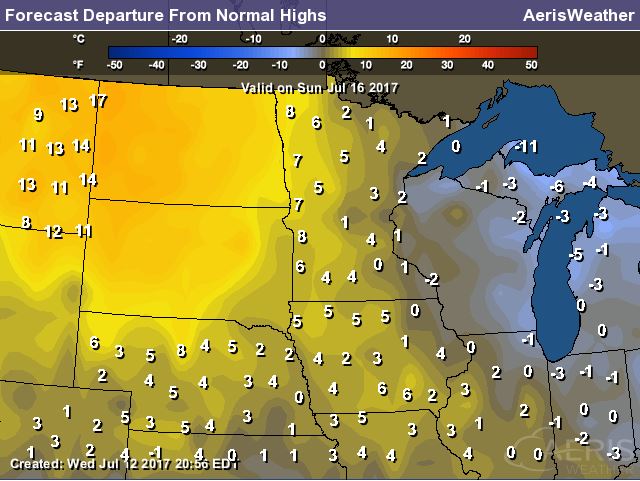
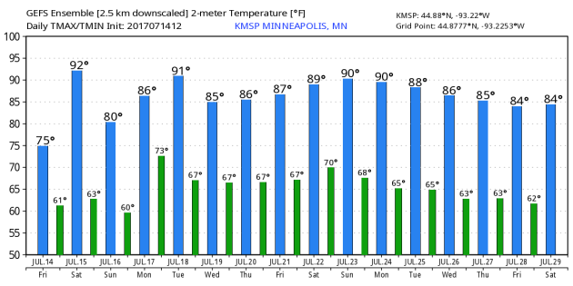
Here's the temperature outlook through July 29th, which shows temperatures warming up quite a bit on Saturday from where we were on Thursday and Friday. There also appears to be some heat spikes as we head into next week. Climatologically speaking, this is the hottest time of the year, so this type of heat is pretty typical for mid July.
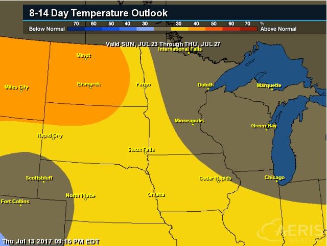
8 to 14 Day Temperature Outlook
According to NOAA's CPC, the extended temperature outlook from July 23rd to July 27th suggests warmer than average temperatures will begin to retreat back to the west as we head into the end of the month. Temps around the Great Lakes could be a little closer to average.
___________________________________________________________
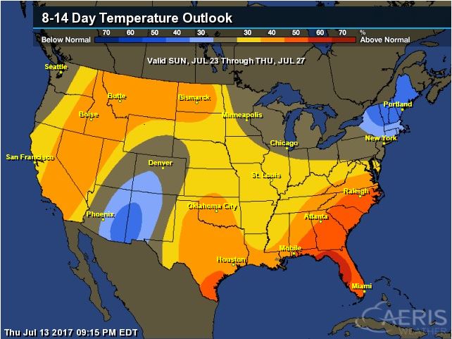
Extended Temperature Outlook
According to NOAA's CPC, the extended temperature outlook through July 27th shows much of the nation will be dealing with above normal temperatures into the second half of the month. The only cooler than average spots maybe located across parts of the Southwestern US due to ongoing monsoonal moisture there, but there may also be some cooler than average temps in the Northern New England States.
 ____________________________________________________________
Weather Outlook This Week
The weather outlook over the next couple of days shows stormy weather continuing across parts of the Southern and Eastern US. Some of the storms could strong to severe with locally heavy rains. There will also be locally heavy rain across the Desert Southwest.
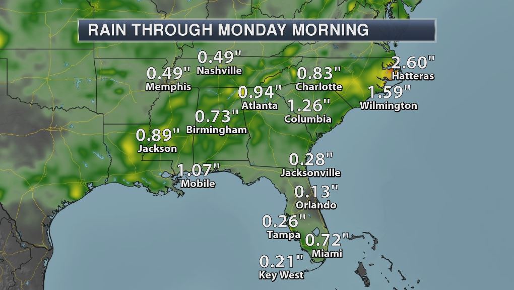
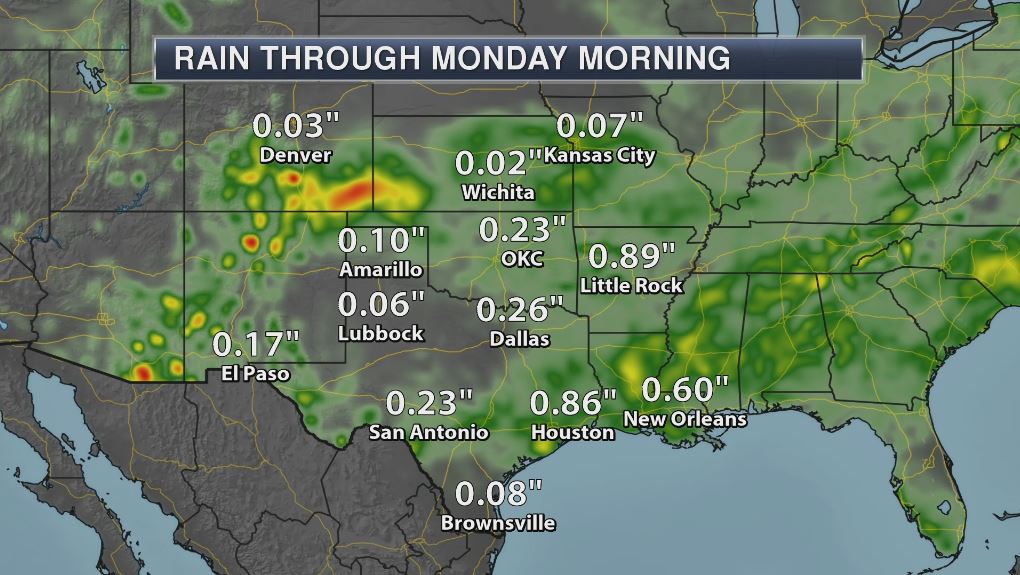
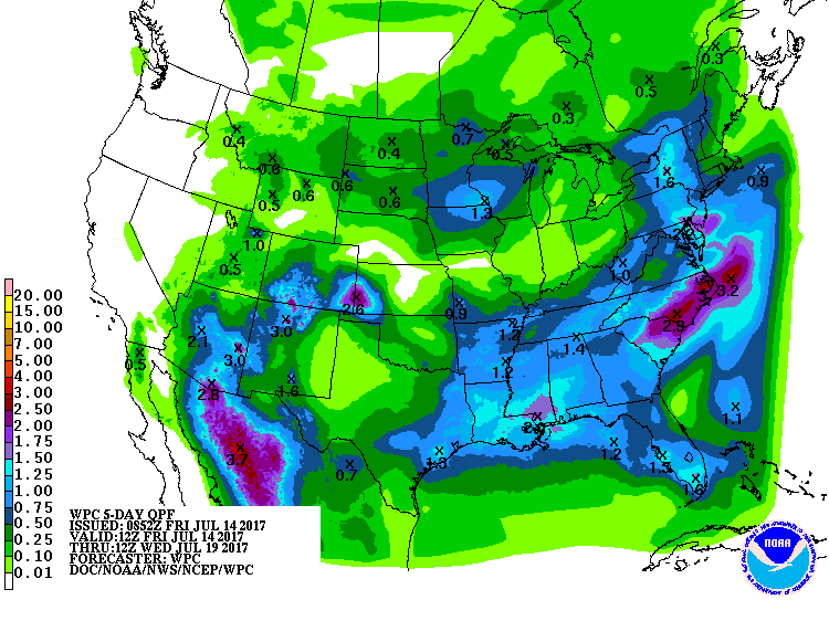
5 Day Precipitation Outlook
According to NOAA's WPC, the next several days could produce areas of locally heavy rainfall across parts of the Eastern and Southern US with some spots picking up nearly 1" to 3". There will also be ongoing monsoon storms across the Desert Southwest with some 1" to 3" tallies. Spotty heavy rain may also be possible across parts of the Upper Midwest as we head into next week.
___________________________________________________________________
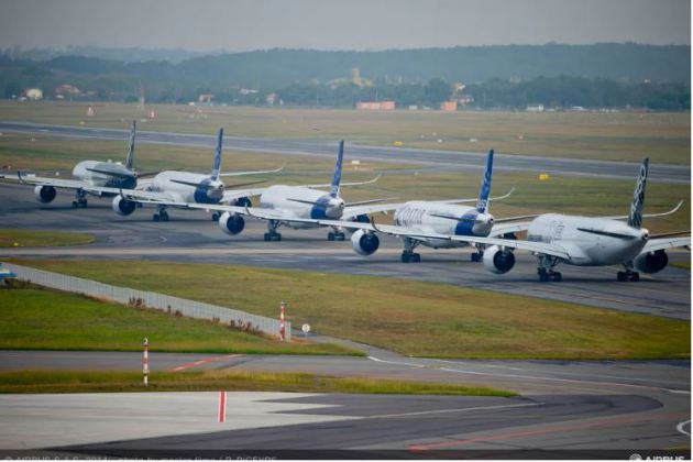
"Climate change is going to make air travel even more nightmarish, study says"
"Last month, Phoenix was hit by a sweltering heatwave, with temperatures reaching 120 degrees Fahrenheit. It was so hot, American Airlines was forced to cancel 50 flightsscheduled to depart Sky Harbor International Airport. The news of the cancellations spread far and wide, as people were interested in learning more about the physics of air travel and how extreme heat affects flying. And now a new study suggests that what happened in Phoenix may be just the tip of the rapidly melting iceberg. Extreme heat is a byproduct of climate change. Experts agree that as the Earth’s temperature rises, these heatwaves will come more frequently, last longer, and be felt more intensely. And this will have an indelible effect on how we use airplanes for travel and commerce. A team of researchers at Columbia University set out to chart exactly how rising temperatures will affect the takeoff and landing performance of aircraft; their findings were published today in the journal Climatic Change."
(Credit: TheVerge.com)
_________________________________________________________________________
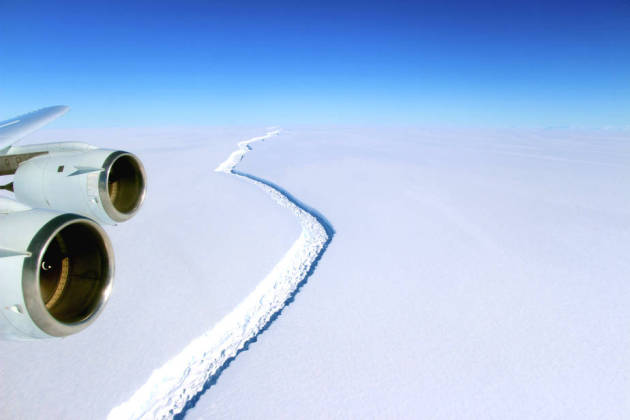
"Trillion-Ton, Delaware-Size Iceberg Breaks Off Antarctica's Larsen C Ice Shelf"
"Like a driver facing a crack in a windshield, scientists have been watching a rift growing across a giant ice shelf in Western Antarctica for years, waiting for the day that it would break. This week, a trillion-ton expanse of ice nearly the size of Delaware broke off into the ocean. "This event will fundamentally change the landscape of the Antarctic Peninsula," scientists involved in Project Midas, which studies the impact of melting on ice shelf dynamics and stability, wrote on its website. The group announced early this morning that satellite data had confirmed the break. The break that sliced off about 10 percent of the Larsen C Ice Shelf was driven by natural processes, and it isn't going to raise sea level on its own because the ice shelf was already floating on the water. But it can't be viewed in isolation."
(“Although this is a natural event, and we’re not aware of any link to human-induced climate change, this puts the ice shelf in a very vulnerable position,” said glaciologist Martin O’Leary. Credit: NASA/John Sonntag)
_____________________________________________________________________
"Even if every country on the planet cuts emissions, the climate would still be screwed"
"A planet devastated by climate change may seem like a distant future. But Earth is already experiencing the effects of rising global temperatures today. Worldwide, the mean rate of sea level rise increased 50% in the last two decades. In 2017, temperatures have already reached their highest levels in history in some areas, from California to Vietnam. The past three years were the hottest on record. These changes are caused by increasing levels of carbon dioxide and methane in the Earth's atmosphere, a product of human activity. And as New York Magazine's David Wallace-Wells recently noted, no single emissions reduction program we have today is enough to prevent climate disaster — not even the Paris agreement. Even if every signatory country in the accord meets its current pledge for reducing emissions — including the US, though Trump has pledged to pull the country out of the agreement — the world is still projected to warm over 2 degrees Celsius by 2050. The Paris agreement points out this reality in a section titled, "Notes with concern."
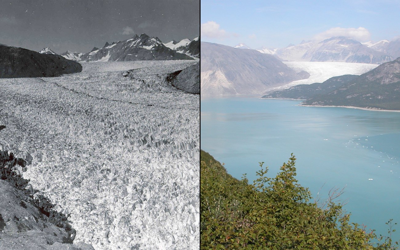
(Photos of Alaska's Muir Glacier in August 1941 (L) and August 2004 (R). Credit: NASA)
_________________________________________________________________
_________________________________________________________________
"Online climate data benefits producers"
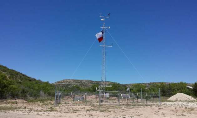
"A group from the USDA Agricultural Research Station (ARS) has introduced a web-based application to help. It allows users to access important historical information about the past climate in their area. This could allow them to better plan for the current year. "We wanted to make an application that addresses some of the most basic questions that producers tend to ask about the current year's weather," explains Steven Mauget of ARS. "How does this year's rainfall or growing degree days compare with recent years? Are soil conditions warm enough to plant? When does first freeze usually occur in my area?" The data in the application comes from mesonet weather stations . A mesonet is a network of weather stations placed at a certain distance from each other—usually about 20 miles apart. These closely-spaced stations shed light on local weather features associated with thunderstorms and gust fronts."
(This mesonet site in Throckmorton County, halfway between Wichita Falls and Abilene, Texas, automatically monitors the weather in the area. Credit: Wes Burgett, Texas Tech University National Wind Institute.)
___________________________________________________________________________
"How to teach kids about climate"
"No politics, no bashing. Skeptical sources like blogs, op-eds, letters to the editor, etc., often include strident criticism of the opposition. There is no place for this in the classroom, especially not in science classes. This is not the place to analyze the reasons for alarmism or the behavior of alarmists."
"Focus on one idea. Many climate change writings have a shotgun blast aspect, offering a broad array of arguments over several distinct topics. For classroom use it is very important to take a single idea and briefly explain it, allowing ample time for discussion. In particular, one should not use any terminology that has not already been taught, except for the terminology being taught. Using terms the students do not know (such as “IPCC” or “anomaly”) will immediately distract the class. These new terms will become the subject, rather than the intended idea."
(Credit: CFact.org)

______________________________________________________________________
"First object teleported to Earth's orbit"
"Chinese researchers have teleported a photon from the Gobi desert to a satellite orbiting five hundred kilometres above the earth. This is achieved through quantum entanglement, a process where two particles react as one with no physical connection between them. Hooke Professor of Experimental Physics at Oxford University Ian Walmsley tells the World At One how quantum entanglement works and how teleportation could be utilised."
________________________________________________________________________
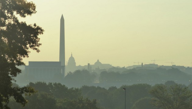
"Stop telling us to use ‘percent humidity.’ It’s terrible and here’s why"
"We get a lot of complaints about humidity. It is, after all, peak summer in D.C. — the nation’s swamp — which it turns out is hard to drain. Sometimes the complaints are about more than just the heavy feeling of sultry moisture and sticky clothes, though. Sometimes the air is so humid that people need more to complain about. Like maybe even the way we talk about humidity in general. There are just some temperatures at which nothing is good enough, you know? Specifically, some of our readers (and listeners) can’t stand that we don’t use “percent humidity.” You may be familiar with this metric from things like third-grade science lessons and the generic weather app on your phone. It’s really easy to understand — on a scale of 1 to 100, how humid is it? Except that’s not at all what percent humidity is describing. Key to this is the modifier to the term that’s often dropped in casual conversation: relative humidity. It’s relative to the temperature."
(A view of Washington. (George Jiang))
__________________________________________________________________________
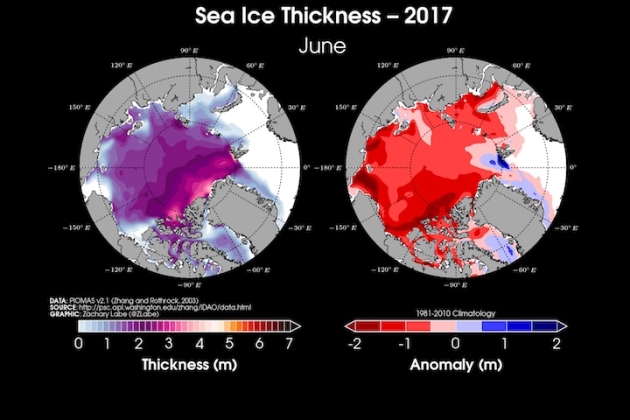
"The Arctic Has Been Crazy Warm All Year. This Is What It Means for Sea Ice"
"Melt season has begun in earnest in the Arctic. Scientists will spend the next few months watching sea ice turn into open water until the ice pack hits its nadir in early fall. The vagaries of the weather and ocean currents will play a major role in determining where this year’s Arctic sea ice minimum ranks. But the steady drumbeat of climate change ensures that it will likely be among the lowest on record. New data from the National Snow and Ice Data Center show that sea ice extent was at its sixth-lowest mark for June. Sea ice was missing from 348,000 square miles of the Arctic Ocean, an area about three times the size of Arizona. After the string of record- or near-record low months late last year and early this year, the sixth-lowest extent might sound like an improvement. It’s not. As of July 2, sea ice extent was on par with 2012, a year that went on to set the mark for lowest Arctic sea ice minimum on record. That year, a major storm in August helped churn the ocean and smash ice to smithereens."
(Total Arctic sea ice thickness and its departure from normal for June. Credit: Zack Labe)
 _____________________________________________________________________
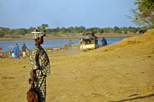
"Warming May Turn Africa’s Arid Sahel Green: Researchers"
"One of Africa's driest regions — the Sahel — could turn greener if the planet warms more than 2 degrees Celsius and triggers more frequent heavy rainfall, scientists said on Wednesday. The Sahel stretches coast to coast from Mauritania and Mali in the west to Sudan and Eritrea in the east, and skirts the southern edge of the Sahara desert. It is home to more than 100 million people. The region has seen worsening extreme weather — including more frequent droughts — in recent years. But if greenhouse gas emissions continue unabated, the resulting global warming — of more than 2 degrees Celsius above pre-industrial levels — could change major weather patterns in the Sahel, and in many different parts of the world, scientists say. Some weather models predict a small increase in rainfall for the Sahel, but there is a risk that the entire weather pattern will change by the end of the century, researchers at the Potsdam Institute for Climate Impact Research (PIK) said. "The sheer size of the possible change is mindboggling — this is one of the very few elements in the Earth system that we might witness tipping soon," said co-author Anders Levermann from PIK and the Lamont-Doherty Earth Observatory of New York's Columbia University."
(The road to Djenne, on the Bani River in Mali. The Sahel region could turn greener if the planet warms more than 2 degrees Celsius. Credit: Carsten ten Brink/flickr)
 ______________________________________________________________________________
"EPA chief wants scientists to debate climate on TV"
"The U.S. Environmental Protection Agency is in the early stages of launching a debate about climate change that could air on television – challenging scientists to prove the widespread view that global warming is a serious threat, the head of the agency said. The move comes as the administration of President Donald Trump seeks to roll back a slew of Obama-era regulations limiting carbon dioxide emissions from fossil fuels, and begins a withdrawal from the Paris Climate Agreement - a global pact to stem planetary warming through emissions cuts. "There are lots of questions that have not been asked and answered (about climate change)," EPA Administrator Scott Pruitt told Reuters in an interview late on Monday."
(Environmental Protection Agency Administrator Scott Pruitt speaks during an interview for Reuters at his office in Washington, U.S., July 10, 2017.)

Thanks for checking in and don't forget to follow me on Twitter @TNelsonWX

No comments:
Post a Comment