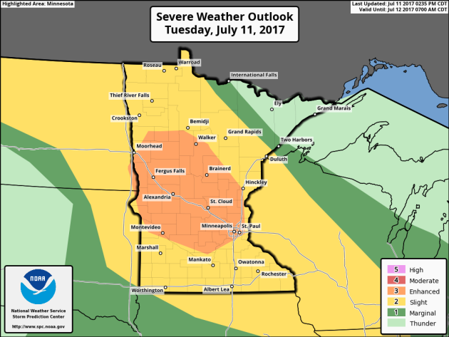
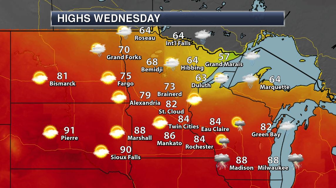
Tuesday Night Severe Threat
Don't let your guard down Tuesday night! The Storm Prediction Center has issued an ENHANCED risk of severe weather for parts of the state, including the Twin Cities for the potential of large hail, damaging winds and even an isolated tornado.
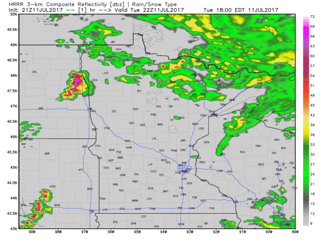
Simulated Radar Overnight Tuesday
Here's the simulated radar from 5pm Tuesday to 10am Wednesday, which shows a large cluster of storms developing over western Minnesota and sliding southeast through the night. Initially, these storms will be capable of large hail and an isolated tornado, but they sill quickly develop into a damaging wind threat as the roll down I-94. They are expected to impact the Twin Cities around midnight... Keep your weather radio handy. I could be a bumpy night.
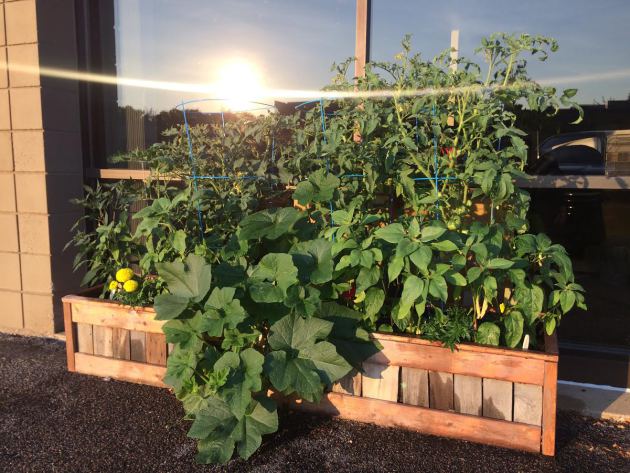
Gardening Problem
I think it's safe to say I have a bit of a gardening problem. Despite having several large gardens at home, I have another at work and still don't have enough space to put everything. If you've fertilized and watered on a regular basis, your gardens should be booming right now! The warm and humid weather has many plants in a growing frenzy.
Severe Weather From Sunday Evening
Take a look at the radar loop from Sunday evening below. Note how quickly the storms developed and became severe. Interestingly, much of the Twin Cities metro got missed, but parts of central, western and southern Minnesota got hammered!
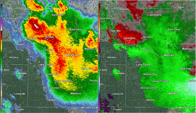
2 Confirmed Tornadoes in Southern MN on Sunday Night
Here's a look at the radar loop from Sunday night's storms across southern MN.
Radar reflectivity (left) and storm relative velocity (right) loop of tornadic storm in southern Nicollet & northwest Blue Earth Counties from 1005 PM through 1045 PM.
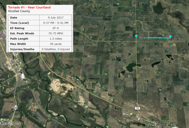
Tornado #1 - Near Courtland - EF0 - Estimated Peak Winds 70-75mph
This tornado occurred just west of Swan Lake about 3 miles north of Courtland in Nicollet County.
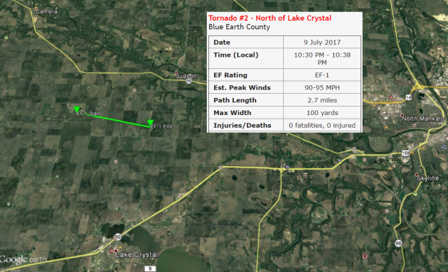
Tornado #2 - North of Lake Crystal - EF1 - Winds 90-95mph
This tornado touched down approximately 4 miles north of Lake Crystal in Blue Earth.
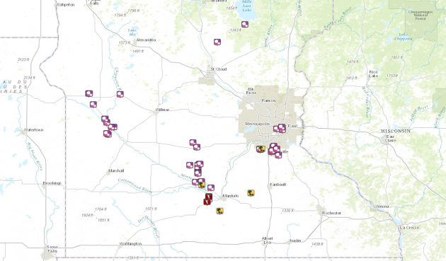
Storm Reports From Sunday
There were 2 tornado reports yesterday across southern Minnesota. Bot of the reports were located in Blue Earth county. Thankfully there were no reports of injuries. Here are the reports:
1.) MULTIPLE SPOTTER REPORTS OF A TORNADO 2 MILES NW OF LAKE CRYSTAL.
2.) LAW ENFORCEMENT REPORTING A TORNADO NEAR THE INTERSECTION OF CR 20 & MN HWY 68.
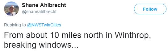
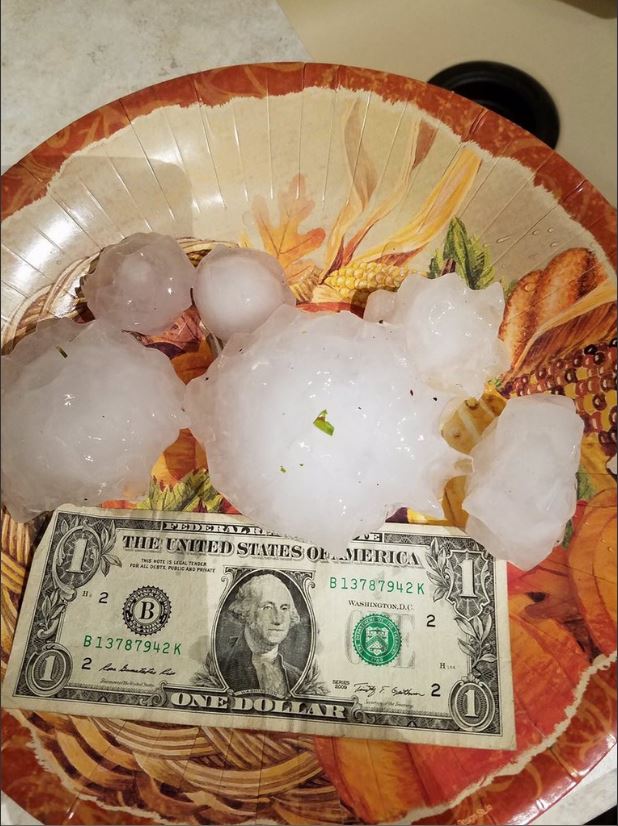
4" Hail in Winthrop
There were also several large hail reports as these storms developed across the region. Take a look at this tweet from @shaneahlbrecht who got this picture from 10 miles north of Winthrop where near 4" hail fell! WOW!!
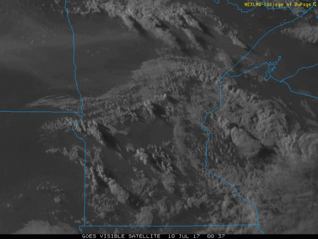
Satellite Loop From Sunday Evening
The visible satellite loop below from Sunday evening into early Monday morning shows the thunderstorms that rapidly developed across the southern half of the state. Note how they seem to 'explode' just prior to sunset. This rapid development occurred because the atmosphere remained capped (too warm) for much of the day. Once this cap eventually broke, thunderstorms exploded as they fed off of the heat and humidity in place across the region.
Severe Threat Shifts Southeast Wednesday
A few leftover strong to severe storms may be possible across parts of southeastern Minnesota on Wednesday and for that reason, NOAA's SPC has issued a MARGINAL and SLIGHT risk of severe weather there. The good news is that the severe threat looks to fade by Thursday.
.png)
.png)
Simulated Radar
The simulated radar from midday Wednesday to Friday shows widely scattered showers and storms pushing well south of the region. In the wake of the storms, a bubble of high pressure will settle in across the Upper Mississippi Valley, which will allow cooler, drier and less humid air to move in, especially on Thursday. Enjoy it because hot and humid weather looks to return by the weekend!
.gif)
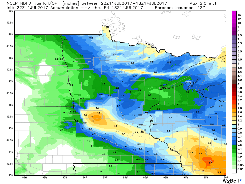
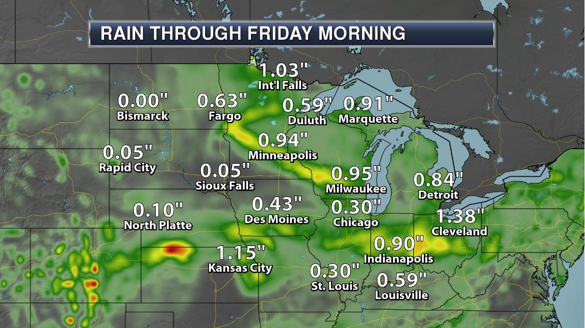
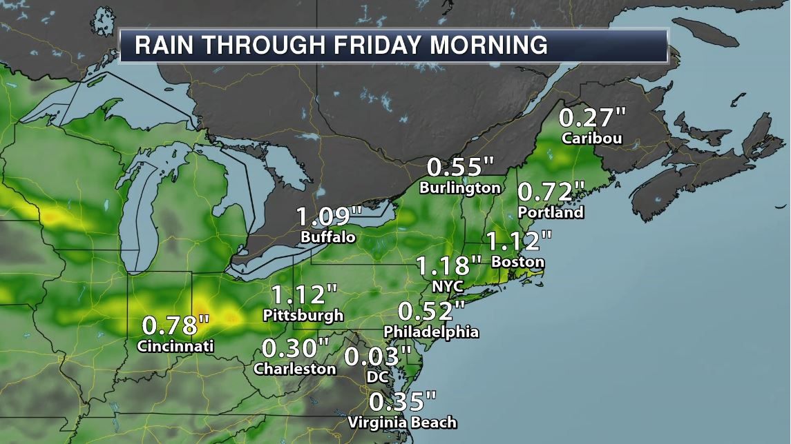
Here's the rainfall potential through midday Friday, which suggests heavy rainfall potential from strong to severe storms that blast through the area late Tuesday. Some locations could see 1" or more by early Wednesday.
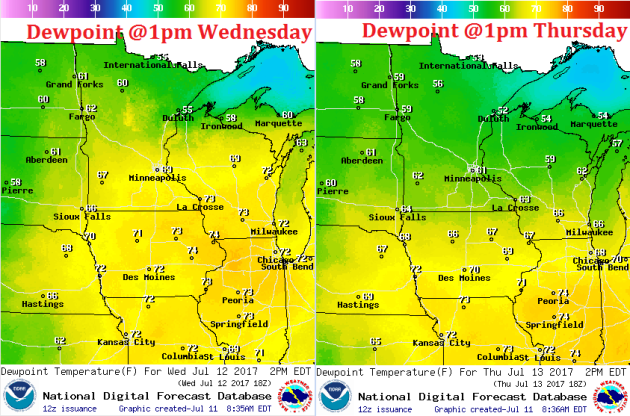
Muggy Wednesday, Not As Bad Thursday
Wednesday will still be quite muggy across the region with dewpoints in the mid to upper 60s. Some across southern Minnesota could see dewpoints in the low 70s at times. The good news is that dewpoints should come down a bit on Thursday with readings in the lower 60s and even back down into the 50s across the central and northern part of the state.
___________________________________________________________________________
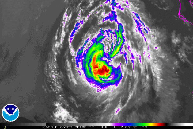
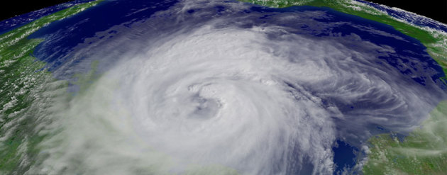
Eastern Pacific Outlook: Hurricane EUGENE
EUGENE continues in the Eastern Pacific and as of early Tuesday, EUGENE was downgraded to a tropical storm with sustained winds of 65mph. EUGENE was a hurricane earlier this week, which made it the 2nd hurricane of the 2017 Eastern Pacific Hurricane season; the other hurricane was DORA.
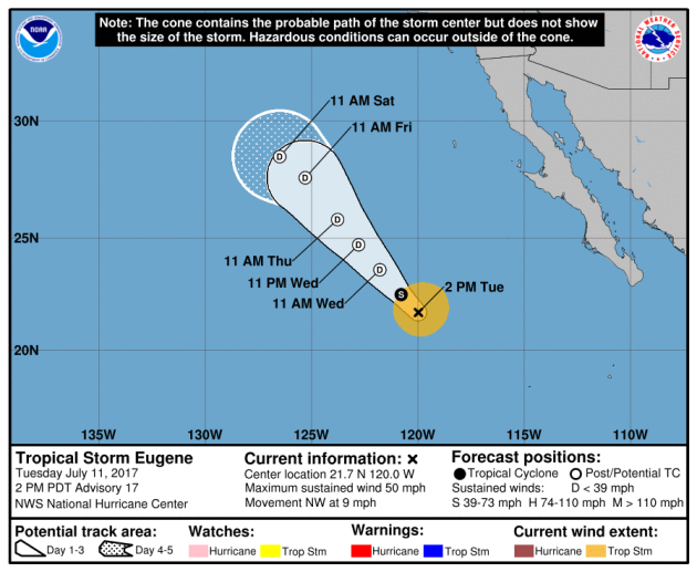
Here's the official track for Tropical Storm EUGENE, which shows it continuing to fade over the next few days. EUGENE could be a tropical depression as early as Wednesday.
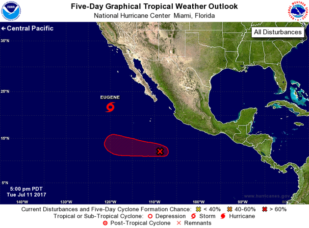
Eastern Pacific Outlook
The National Hurricane Center is also keeping an eye on another wave of energy south of EUGENE that now has a HIGH chance of tropical development within the next 5 days. The good news is that this system looks to also drift west, away from any major land mass.
_______________________________________________________________
"Why do we name tropical storms and hurricanes?"
Have you ever wondered why we name tropical storms and hurricanes? Here's an excerpt from NOAA: "Until the early 1950s, tropical storms and hurricanes were tracked by year and the order in which they occurred during that year. Over time, it was learned that the use of short, easily remembered names in written as well as spoken communications is quicker and reduces confusion when two or more tropical storms occur at the same time. In the past, confusion and false rumors resulted when storm advisories broadcast from radio stations were mistaken for warnings concerning an entirely different storm located hundreds of miles away. In 1953, the United States began using female names for storms and, by 1978, both male and female names were used to identify Northern Pacific storms. This was then adopted in 1979 for storms in the Atlantic basin."
(Hurricane Ike (2008), the third costliest storm in United States history)
1.) Excessive heat for parts of the mid-Atlantic and Southeast, Fri, Jul 14.
2.) Much above-normal temperatures for much of the northern Rockies and northern Great Plains, Fri-Tue, Jul 14-18.
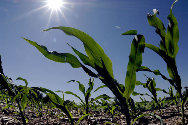
3.) Excessive heat for parts of the western Corn Belt and middle Mississippi Valley, Tue, Jul 18.
4.) Heavy rain shifting south across the Northeast and mid-Atlantic, Fri-Sat, Jul 14-15.
5.) Heavy rain for parts of the Southeast, Sun-Mon, Jul 16-17.
6.) Much above-normal temperatures for the Yukon Valley of Alaska, Fri, Jul 14.
7.) Flash flooding possible for parts of the southwestern U.S., July 14-25.
8.) Moderate risk of much above-normal temperatures for the Dakotas and western Minnesota, Wed, Jul 19.
9.) Slight risk of much above-normal temperatures extending from the northern Rockies east to the Great Lakes, Ohio Valley, and central Appalachians, Wed-Sun, Jul 19-23.
10.) Severe Drought across parts of the Great Plains, Arizona, California, and Hawaii.
.png)
Excessive Rainfall Potential Wednesday & Thursday
According to NOAA's WPC, there is a risk of excessive rain on both Wednesday & Thursday, On Wednesday, areas across the Great Lakes are under a SLIGHT risk of excessive rainfall, which is surrounded by marginal excessive rainfall potential. There is also a chance of heavier rains across the Central US and Ohio Valley again on Thursday.
.gif)
.gif)
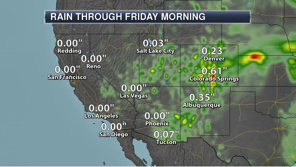
With excessive rainfall potential in place over parts of the northern tier of the nation over the next couple of days, here's how much rain could fall through Thursday morning. Note that some spots could see up to 1" to 2"+ which could lead to localized areas of flooding.
________________________________________________________
Weather Outlook
Here's the weather outlook through the weekend, which shows unsettled weather conditions continuing across the northern tier of the nation. Keep in mind that some of the storms could be strong to severe with locally heavy rainfall. There will also be areas of thunderstorm activity across the Intermountain West with monsoonal storms in the Desert Southwest. Also note Hurricane EUGENE fading in the Eastern Pacific as we head through the week.
.gif)
_________________________________________________________________
PRELIMINARY 2017 Tornado Map
It certainly has been a fairly active first half of 2017 with 1139 preliminary tornado reports through July 9th. Note that this is the most tornadoes through July 9th since 2011, when there were nearly 1,600 reports. The map below shows the distribution of the tornadoes so far this year.
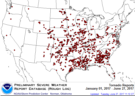
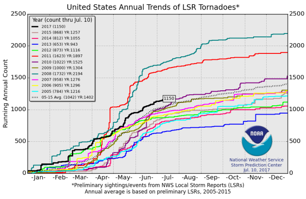
PRELIMINARY 2017 Tornado Count
According to NOAA's SPC, the PRELIMINARY 2017 tornado count is 1150 (through July 10). Note that is the most active year for tornadoes since 2011, when there were 1,623 tornadoes. Keep in mind there was a major tornado outbreak in the Gulf Coast region from April 25-28, 2011 that spawned nearly 500 tornadoes, some of which were deadly. That outbreak is known as the Super Outbreak of 2011 and has gone down in history as one of the biggest, costliest and one of the deadliest tornado outbreaks in history.
_________________________________________________________________
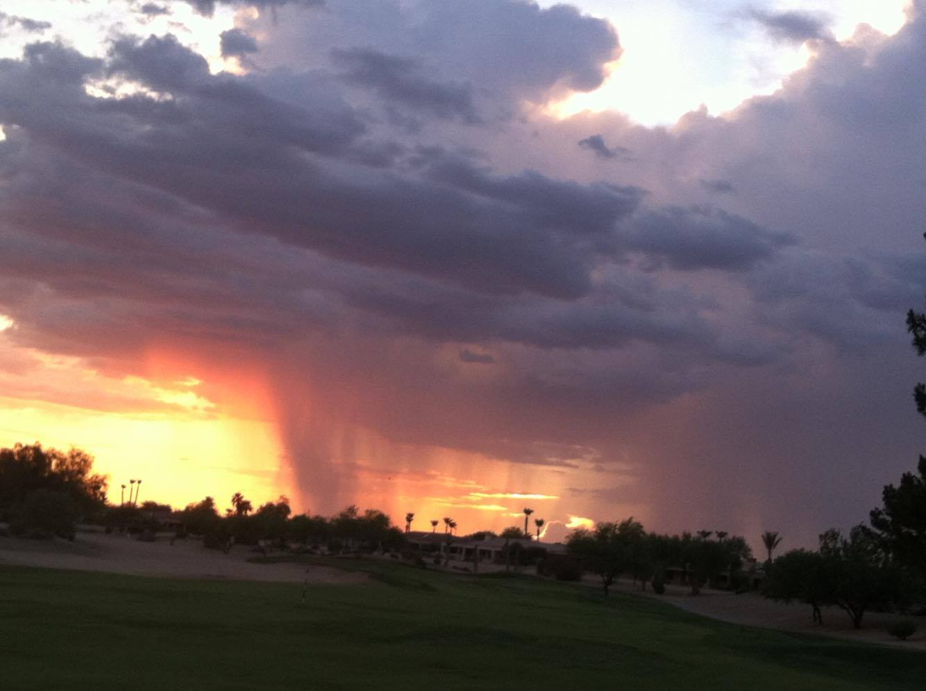
Monsoonal Storms
Thanks to Randy Musil for the picture below who enjoyed the light show of a distant thunderstorm on the Golf in Arizona on Monday evening. Spotty showers and storms have been bubbling up over the last several days across the Southwest and look to continue to be the case over the next several days.
Monsoonal Storms Continue
Sure it'll be hot in Phoenix, AZ over the next few days, but hey look at the thunderstorm chances! Monsoonal storms could bubble up across the region there over the next several days! Rainfall amounts could be heavy in pockets, which could lead to areas of localized flooding across the Desert Southwest.
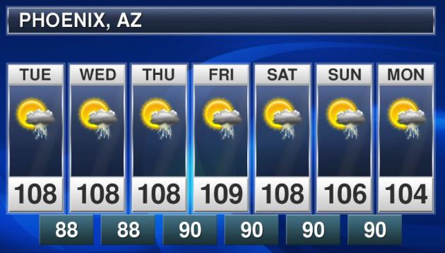
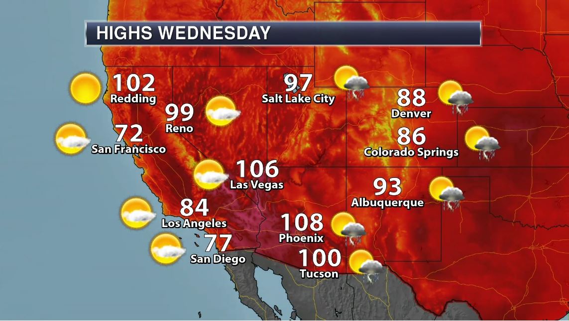
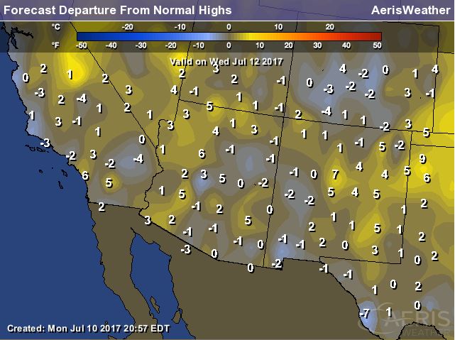
Hot, But Not As Hot in the Southwest
The good news is that the excessive heat has subsided in the Southwest for now. Temperatures late last week and into the weekend were at record levels in quite a few locations. Here's a look at high temperatures for Wednesday, which will be a little closer to average and in fact, may even be a little cooler than average for a few spots.
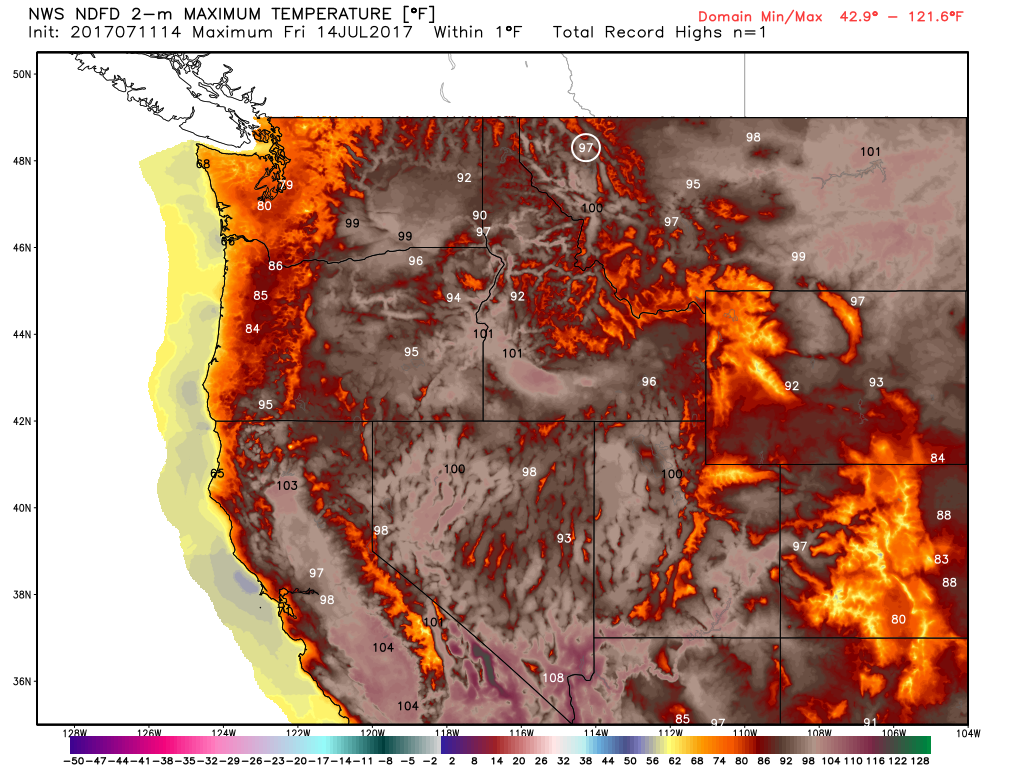
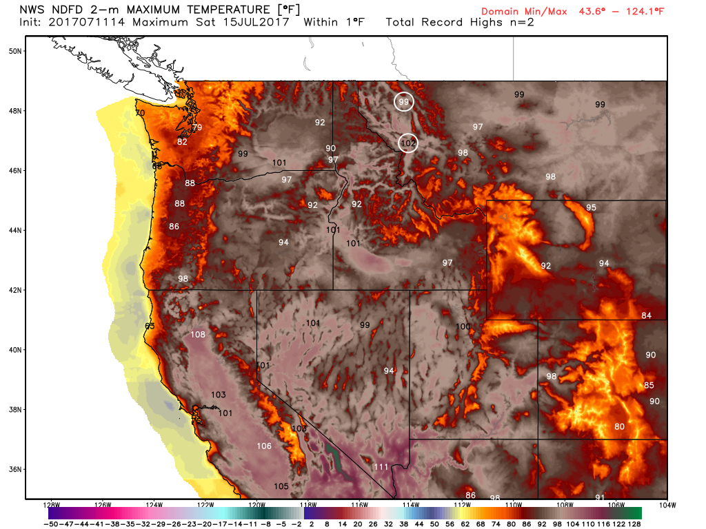
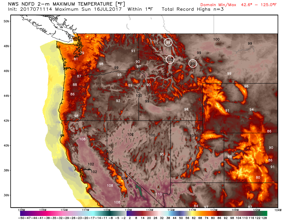
Record Heat Possible in the Northwest
The extended forecasts from Friday, Saturday & Sunday suggests that record to near record heat will be building into the Northwest. Some forecasts suggest that readings could be a good 15F to 20F+ above average, especially over the weekend. The images below show the potential record highs for Friday, Saturday & Sunday respectively.
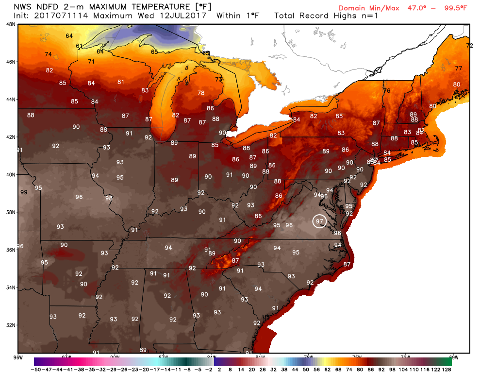
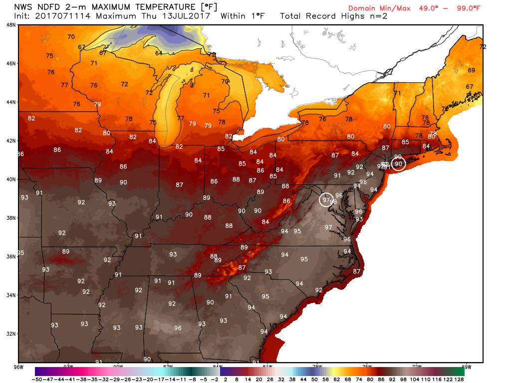
Record Heat in the Mid-Atlantic Wednesday & Thursday?
A surge of very warm and soupy air is expected to bubble up across the Mid-Atlantic region on Wednesday and Thursday. Some locations will be nearly 10F+ above average record highs could be possible as highs warm into the upper 90s.
_______________________________________________________________________
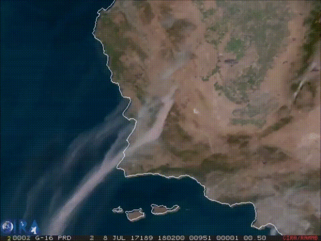
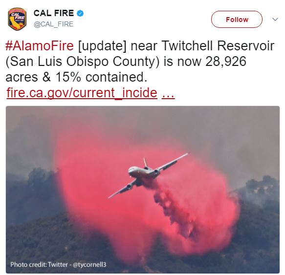
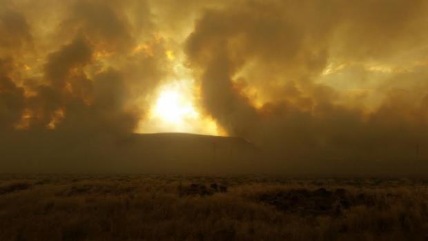
Alamo Fire - Near Santa Maria, California
According to Cal Fire, the Alamo Fire located Santa Maria, California has consumed nearly 29,000 acres since Thursday, July 6th. The good news is that the fire is 45% contained as of early Tuesday, but mandatory evacuations are still in place for Tepusquet Canyon. There are 2,027 people working on the fire, which is being fueled by the hot and dry conditions there. The satellite loop below shows smoke from the fire drifting northeast from last weekend.
@CAL_FIRE on Twitter
A good follow on Twitter for all California wildfire information is @CAL_FIRE.
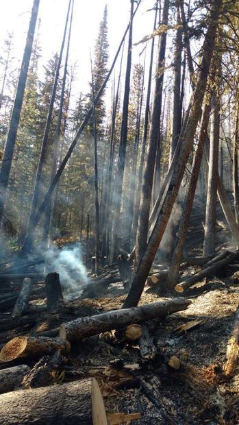
The Peak 2 Fire - Near Breckenridge, CO
According to Inciweb, the fire being dubbed the Peak 2 Fire, which is located 2 miles north of the Breckenridge Ski Resort has stopped spreading at this point and is considered to be 85% contained. Pre-Evacuation order have been lifted as well, so things seem to be getting under control after that fire quickly started and spread last week. Here's a excerpt from Fox 31 News (KDVR) regarding the fire: "The pre-evacuation orders for the Peak 2 Fire near Breckenridge were lifted Sunday afternoon. The fire was 84 acres in size and 85 percent contained as of Sunday evening, the Rocky Mountain Incident Management Team said. It is burning in the Miner’s Creek drainage two miles north of Breckenridge Ski Area. There is no direct threat to the town of Breckenridge. Evacuations for nearly 500 residences were lifted Friday night, but the Peak 7 neighborhood remained on pre-evacuation status until Sunday afternoon."
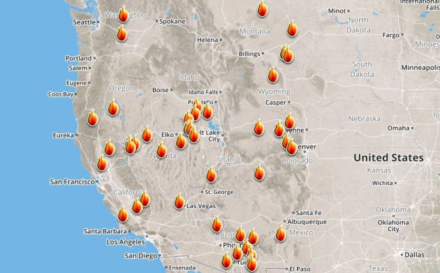
Ongoing Large Wildfires
Here's a look at the current wildfires across the Western US. The recent hot weather has allowed tinder dry conditions to develop, which has led to several wildfires popping up
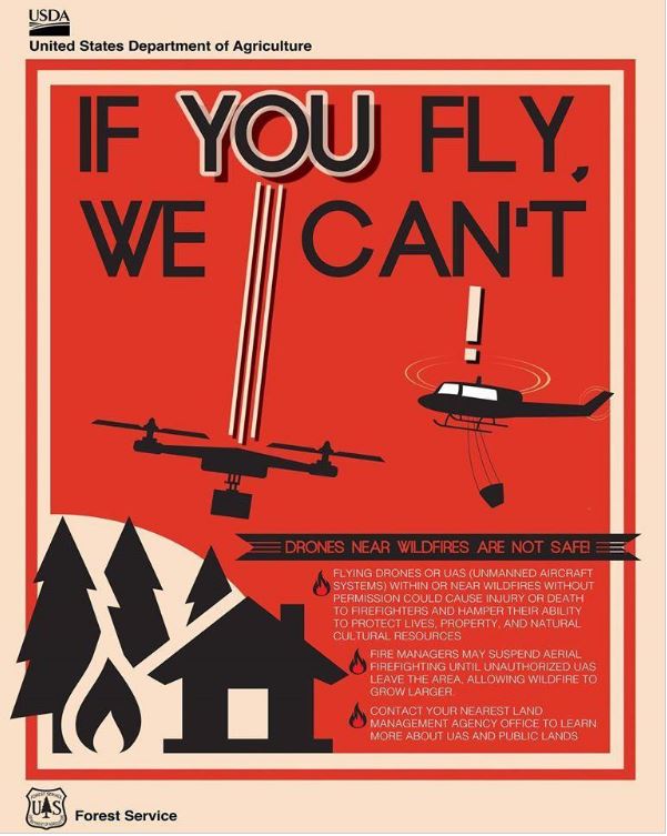
Here's an interesting story regarding drones causing air support to be grounded during wildfires! Here's the latest from Fox 31 in Denver (KDVR): "Fire departments statewide are pleading with the public to follow the rules when it comes to drones around active wildfires. Flying high above the ground, drones give a bird’s-eye view of the world. From cityscapes to places off-limits to the public, they can soar into fires like never before. “We certainly see the benefit in fact South Metro is seeing a few people to get properly trained,” South Metro Fire Rescue spokesman Eric Hurst said. However, sometimes drones can also be a hazard for fire crews. On Saturday, South Metro was one of four agencies responding to a grass fire in Sedalia. The 18-acre fire required air support but couldn’t utilize it as planned. “During [Saturday’s] incident, one of our fire crews observed a drone flying around the scene, so that triggers a lot of concerns for us,” Hurst said. A drone in the immediate area of a wildfire makes conditions too unsafe for airplanes. If the two collide, it could cause the plane to crash. “The pilots don’t want to be up in the air when they can’t communicate with another aircraft that’s flying next to them,” Hurst said. A similar situation happened at the Lightner Creek Fire in Durango last week. Planes carrying fire retardant were forced to drop their loads early and leave the area because of an unauthorized drone in the flight path. “We don’t want any kind of an accident to happen so at that point, aircraft is going to have to be grounded until we can find out who’s operating the drone and we can get them to stop,” Hurst said."
Truckee Fire - Located 10 Miles NW of Fernley, NV
According to Inciweb, one of the largest fires that was recently just burning was located 10 miles NW of Fernley, NV. The fire consumed nearly 100,000 acres since Monday, July 3rd. The good news is that the fire is now fully contained, but the cause is unknown at this point.
 ________________________________________________________________________
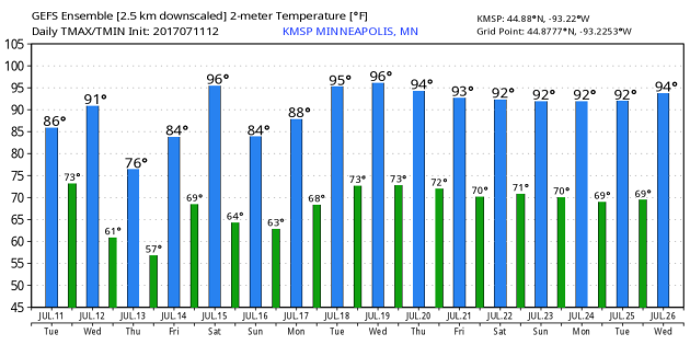
Sticky Wednesday. Cooler Thursday. Hot Weekend
By Todd Nelson, filling in for Douglas
By Todd Nelson, filling in for Douglas
According to NOAA's NCDC, the Twin Cities averages 7.3 thunderstorm days during the month of July. That is second to June, which averages 7.5 days. However, peak heat and humidity during the month of July tends to turn our thunderstorm days into nights.
A "capped" atmosphere describes temperatures that are too warm for thunderstorms to develop. In the summer months, the "cap" can suppress storms during the day, allowing tremendous energy to build. If surface temperatures get warm enough, that cap can break. The end result? Explosive thunderstorms, some of which release as much energy as an atomic bomb - no joke!
Tuesday night's thunderstorms will move east of us Wednesday, but nagging clouds and muggy air will stick around. Temps fall into the 70s on Thursday with a brief break in humidity.
Looking ahead, several days of hot and sweaty weather look to bubble back into the region. By the weekend, highs will again flirt with 90 degrees, but could be in the mid 90s by Wednesday of next week! WHEW! I'm hot just thinking about it...
______________________________________________________
______________________________________________________
Extended Forecast
WEDNESDAY: Lingering AM storm. Still quite sticky. Winds: NNW 5-10. High: 85.
WEDNESDAY NIGHT: Partly cloudy and quiet. Winds: NE 5-10. Low: 60
THURSDAY: Lingering clouds. Cooler & less humid. Winds: NNE 5. High: 76.
FRIDAY: Bright sun Heating up again! Winds: SSE 5. Wake-up: 61. High: 84.
SATURDAY: Hot & sweaty. Few rumbles possible overnight Winds: W 5. Wake-up: 69. High: 90
SUNDAY: Lots of sun. Find some A/C. Winds: SE 5. Wake-up: 71. High: 88.
MONDAY: Toasty. Spotty late day thundershower? Winds: SW 5-15. Wake-up: 70. High: 90.
TUESDAY: Still stinkin' hot. Winds: SW 5-15. Wake-up: 72. 92.
_______________________________________________________
_______________________________________________________
This Day in Weather History
July 12th
July 12th
1863: Unseasonably cool temperatures are felt across the state. Frost is reported in the Twin Cities area.
________________________________________________________
________________________________________________________
Average High/Low for Minneapolis
July 12th
July 12th
Average High: 84F (Record: 106F set in 1936)
Average Low: 64F (Record: 48F set in 1941)
Average Low: 64F (Record: 48F set in 1941)
Record Rainfall: 2.93" set in 1912
_________________________________________________________
_________________________________________________________
Sunrise/Sunset Times for Minneapolis
July 11th
July 11th
Sunrise: 5:39am
Sunset: 8:58pm
Sunset: 8:58pm
Hours of Daylight: 15hours & 20mins
Daylight LOST since yesterday: ~1 minute and 27 seconds
Daylight LOST since summer solstice (June 20th): ~17 minutes
__________________________________________________________
Daylight LOST since summer solstice (June 20th): ~17 minutes
__________________________________________________________
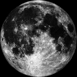
Moon Phase for July 12th at Midnight
3.5 Days Before Last Quarter
3.5 Days Before Last Quarter
_________________________
Weather Outlook For Wednesday
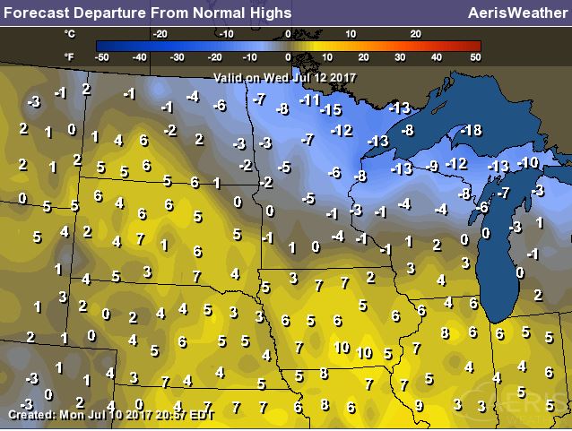
Wednesday still looks to be a bit sticky across the region, but the good news is that temperatures won't be quite as hot as they were on Tuesday. There may also still be a few leftover storms across far southern and southeastern MN.
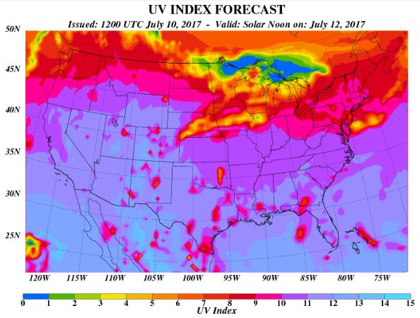
UV Index for Wednesday - HIGH
The UV Index will be considered HIGH across much of the state of Minnesota on Wednesday, which means that it will only 15 to 20 minutes or less to burn unprotected skin. With that said, if you are planning on spending any extended length of time outside, make sure you wear appropriate attire and lather on the sun block!
__________________________________________________________________________
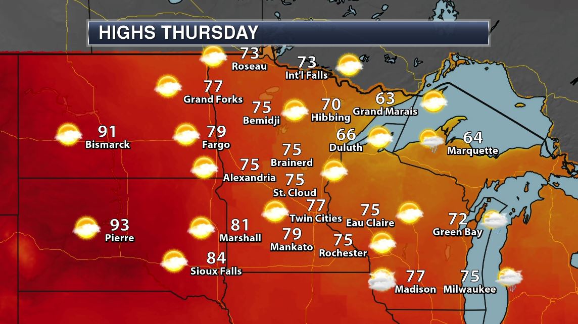
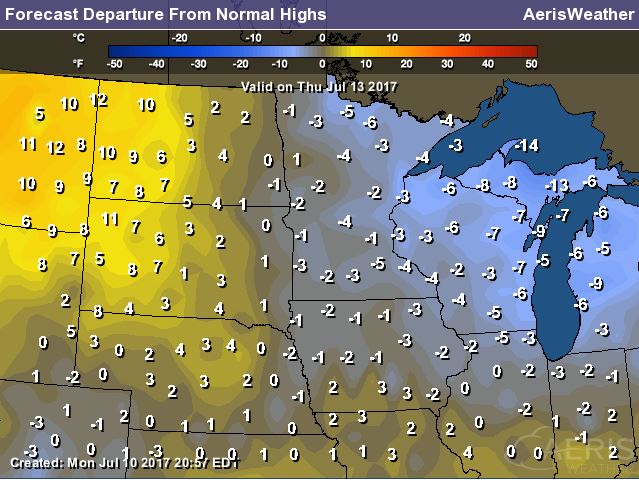
Weather Outlook For Thursday
Look at temperatures on Thursday. Considering that temperature have been so warm as of late, readings on Thursday will feel quite cool! Several locations may not even make it out of the 70s, while a few locations across the Arrowhead and northern Wisconsin may not even make it of of the 60s. With that said, temperatures will be running up to 5F or more below average.
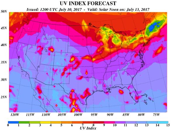
UV Index for Thursday - HIGH
Despite dealing with a little more cloud cover, the UV Index will be considered HIGH across much of the state of Minnesota on Thursday, which means that it will only 20 to 30 minutes or less to burn unprotected skin. With that said, if you are planning on spending any extended length of time outside, make sure you wear appropriate attire and lather on the sun block!
_____________________________________________________________
Temperature Outlook
Here's the temperature outlook through July 26th, which shows a very brief cool down on Thursday, but we should already be back in the heat and humidity by the weekend. The extended outlook suggests a string of low/mid 90s developing through much of next week and into the 4th full week of July.
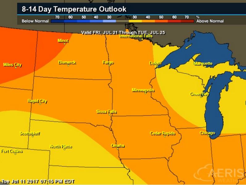
8 to 14 Day Temperature Outlook
According to NOAA's CPC, the extended temperature outlook from July 21st to July 25th suggests warmer than average temperatures continuing across much of the Upper Midwest.. The second half of the month could be quite steamy. Stay tuned...
___________________________________________________________
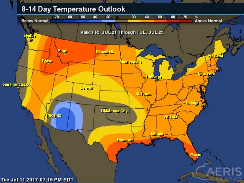
Extended Temperature Outlook
According to NOAA's CPC, the extended temperature outlook through July 25th shows much of the nation will be dealing with above normal temperatures into the second half of the month. The only cooler than average spot maybe located across parts of the Southwestern US.
____________________________________________________________
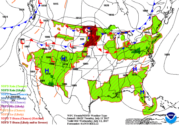
Weather Outlook This Week
The weather outlook over the next couple of days shows stormy weather continuing across the northern tier of the nation. Keep in mind that some of the storms could be strong to severe with areas of locally heavy rainfall. There will also be a continuation of monsoonal storms across the Southwestern US.
5 Day Precipitation Outlook
According to NOAA's WPC, the next several days could produce areas of locally heavy rainfall across parts of the Midwest, northern Ohio Valley, Great Lakes and into the Northeast. This particular model suggests nearly 1" to 3"+ inches through the weekend. There may also be a few pocket of heavy rain along the Gulf Coast and East Coast, while pockets of heavy rainfall could also be found in the Southwest.

___________________________________________________________________
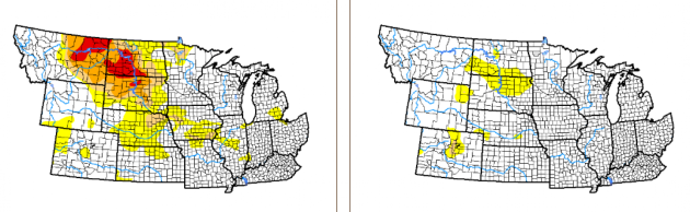
"Drought maintains strong hold on Dakotas, Montana"
"Areas of severe drought and extreme drought expanded this past week across eastern Montana, south-central North Dakota and northwestern South Dakota, where hot and dry conditions persisted, according to the United States Drought Monitor. Rainfall accumulations were generally less than 1 inch, providing little relief. In North Dakota, extreme drought conditions moved from 25 percent of the state to 30 percent of the state in the past week. The only counties that saw enough rain to lose drought status were Walsh, Nelson, Grand Forks and northern portions of Griggs, Steele and Traill on the east side of the state."
(Image Credit: Mike McCleary via BismarckTribune)
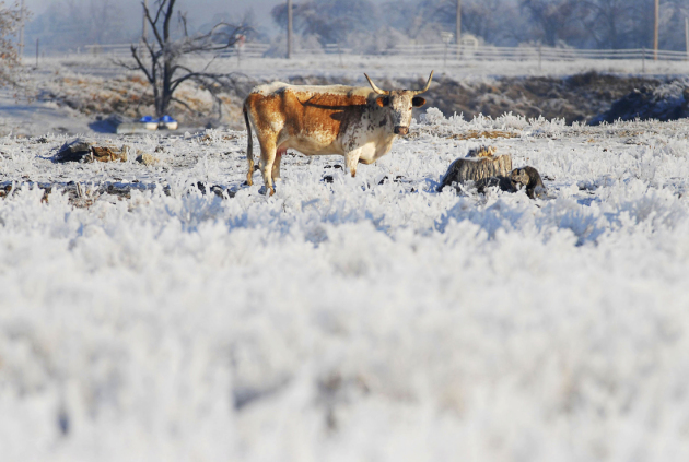
"Extreme heat broils the Dakotas and Montana; flash drought takes toll on wheat crop"
"A massive and intense heat dome has spread over the northern Plains and mountain West, sucking moisture out of the soil, and may persist for weeks. The scorching heat and absence of rain have spurred a rapidly intensifying drought that is decimating the region’s wheat crop. Temperatures in Montana, Wyoming and the Dakotas surged into the 90s and 100s on Wednesday, about 15 to 20 degrees above normal. Forecast models predict the same general weather pattern that supported this heat to persist up to two more weeks. The dry pattern commenced in the spring but intensified in recent weeks as the western heat dome settled in. Glasgow, Mont., had its record-driest April-through-June period. The suddenness of the drought’s onset and expansion has been remarkable. In early May, the U.S. Drought Monitor classified neither the Dakotas nor Montana in a drought. Eight weeks later, drought covered 47 percent of North Dakota, 34 percent of South Dakota, and much of the eastern third of Montana — and its intensity is severe to extreme in many areas. In late June, the U.S. Department of Agriculture declared 15 North Dakota counties as agricultural disaster areas."
___________________________________________________________________________
Will global warming change Native American religious practices?
"The Colorado River, one of the longest rivers in the United States, is gradually shrinking. This is partly a result of overuse by municipalities and seasonal drought. The other reason is global warming. The decline in the river reservoir will have serious implications for large U.S. cities, such as Los Angeles, that depend on the Colorado River as their water source. In addition, this will also have an impact on the Native American tribes who view the Colorado River as sacred to their religions."
(Lake sturgeon on Bad River in Wisconsin. USFWSmidwest, CC BY)
 _______________________________________________________________________
"Why the Weather on the Great Plains Is So Extreme"
"It can be tough to live on the Great Plains. The flat terrain gives way to breathtaking views of both land and sky, but the smooth, fertile land is both good fortune and a curse when it comes to the weather. Whether it's an enormous thunderstorm or a ferocious blizzard, there's rarely a dull day when it comes to weather in the middle of the country. Just what is it about the central United States that makes the weather there so extreme? The unique geography that makes this part of the country so grand is what exposes it to some of the most extreme weather nature can produce. The Plains are bounded by the Rocky Mountains to the west, the Canadian Prairies to the north, and the Gulf of Mexico to the south. The tall, jagged mountains of the Rockies act like an atmospheric dam, forcing hot air from the south and cold air from the north to pool up over the Plains. This helps to trigger some of the most interesting weather in the world."
(Credit: BRANDI SIMONS/GETTY IMAGES via MentalFloss.com)
 ______________________________________________________________________
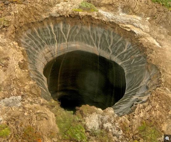
"Oozing Methane Blasts Holes in Siberian Tundra"
"Escaping methane gas has blown at least two new holes in the Siberian tundra in the past few months, according to eyewitness accounts to the Siberian Times and the Russian Academy of Sciences. Reindeer herders northwest of the village of Seyakha in Siberia's far north reported seeing an eruption of fire and smoke on the morning of June 28 — an event caught on seismic sensors at 11 a.m. local time, according to The Siberian Times. Scientists visiting the site photographed a fresh crater blown into the banks of a river. Researchers also discovered a second, previously unknown crater in the Tyumen region of Siberia this month."
(A crater on the Yamal Peninsula in Siberia, reported in the spring of 2017. Credit: Itar-Tass/Zuma)
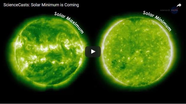
"Solar minimum is coming"
"The sun is heading towards another minimum in the 11-year sunspot cycle, say NASA scientists, expected in 2019-2020. During solar minimum, intense activity – such as sunspots and solar flares – subsides, and the suns’s activity changes form. This new NASA ScienceCast video will give you some basic facts about solar minimums, and what to expect with the one that’s coming. For example, during solar minimum, the sun can develop long-lived coronal holes, like the one on the sun now. And, during solar minimum, the effects of Earth’s upper atmosphere on satellites in low-Earth orbit changes. Plus, there are unique space weather effects that get stronger during solar minimum. All in all, the sun-Earth relationship – which is constantly in flux – has its own unique aspects during a solar minimum."
 ___________________________________________________________
Thanks for checking in and don't forget to follow me on Twitter @TNelsonWX

No comments:
Post a Comment