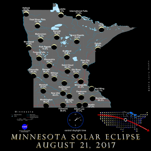
Minnesota Eclipse Forecast
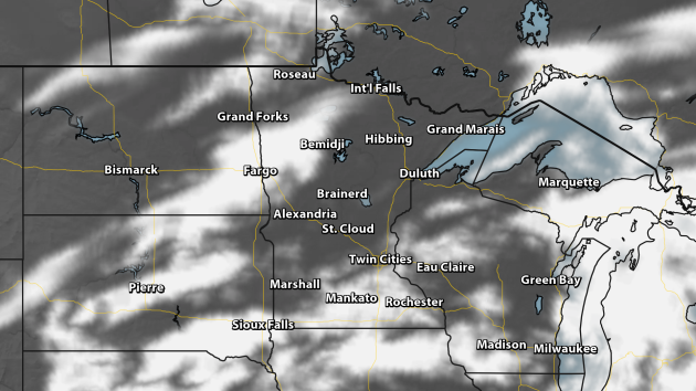
Cloud forecast for 1 PM CT Monday. Credit: AerisWeather/Praedictix.
Are
you preparing for the partial eclipse here across the state Monday? It
looks like we will have to contend with some cloud cover during the time
frame of maximum coverage of the sun, which will occur at 1:06 pm in
Minneapolis with 83% coverage. The partial eclipse begins at 11:43 am,
ending at 2:29 pm.
The
best chance of seeing a few breaks in the cloud coverage appears to be
across northern Minnesota right now during the 1 PM hour Monday.
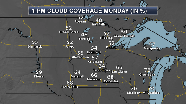
Here's what it would look like at maximum coverage across the state of Minnesota. Shadow and Substance has more maps for across the nation if you would like to see how the eclipse will look like in other states/cities.
_______________________________________________
No 90s So Far In August 2017
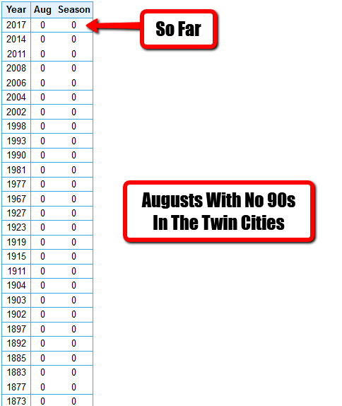
Want
to know how cool it really has been so far this August in the Twin
Cities? The warmest high that has occurred was 89 - back on the 1st.
Yes, we have not hit 90 so far. This is in a month that averages 2.6
days with a high of 90+ (out of the 10.6 we average per year). So, how
often does this happen? Since records began back in the 1880s, we have
had 26 previous Augusts with no 90s during the month - the most recent
back in 2014. The extended forecast (which you can find later in this
post) continues to show no 90s in sight, so we easily could end up with
the 27th August with no 90s.
_______________________________________________
Risk of an Eclipse, But Will We Even See It?
By Paul Douglas
I predict precious little will get done around midday today. For the first time in 99 years a total solar eclipse will track from coast to coast. Will it be visible - or is this the astronomical version of a predicted blizzard that results in a few lonely snow flurries? Insert yawn here.
Even if clouds linger (a good bet over southern counties) skies will darken, and peak eclipse around 1 PM will resemble twilight - an eerie, almost macabre sight.
Public service reminder: clouds won't shield you from the damaging effects of staring at the sun. Only special eclipse glasses or welding goggles are safe.
Skies clear tomorrow (naturally) as a flush of Canadian air drops humidity levels - a rare run of dry weather Tuesday into Friday. A moist southerly flow fuels more showers and T-showers next weekend (naturally) with highs in the upper 70s. We may go through an entire Minnesota State Fair without any obnoxious heat. Mea culpa.
Expect a cool bias into Labor Day, but a run of 80s should return in September. Remember, Minnesota's summers are super-sized now. I'm OK with that.
_______________________________________________
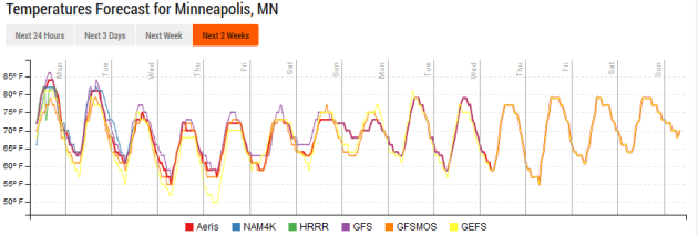
Extended Twin Cities Forecast
MONDAY: Clouds, stray T-shower. High 79. Low 60. Chance of precipitation 40%. Wind E 3-8 mph.
TUESDAY: Fresh air! Sunny, breezy and cooler. High 75. Low 56. Chance of precipitation 10%. Wind NW 10-15 mph.
WEDNESDAY: Sunny and spectacular. High 73. Low 55. Chance of precipitation 10%. Wind NW 7-12 mph.
THURSDAY: Comfortable sun at Day 1 of State Fair. High 76. Low 59. Chance of precipitation 10%. Wind SE 5-10 mph.
FRIDAY: More clouds, a little stickier. High 78. Low 63. Chance of precipitation 20%. Wind SE 7-12 mph.
SATURDAY: Unsettled, few T-storms nearby. High 81. Low 62. Chance of precipitation 50%. Wind S 10-15 mph.
SUNDAY: Some sun, nagging thunder threat. High 80. Low 59. Chance of precipitation 50%. Wind SW 7-12 mph.
_______________________________________________
This Day in Weather History
August 21st
August 21st
1918: Minnesota's third deadliest tornado strikes Tyler and destroys the downtown area, leaving 36 dead.
1886: High winds hit Northfield with winds blowing at 60 mph for 20 minutes. Peak gusts up to 75-80 mph are recorded.
1883:
The 4th deadliest tornado in Minnesota history hits Rochester. The
tornado kills 31 residents and injures 100 more. Appalled by the lack of
medical care received by the tornado's victims, Mother Alfred Moes,
founder of the Sisters of St. Francis, proposes to build and staff a
hospital if Dr. W.W. Mayo will provide medical care. St. Marys Hospital
opens in 1889 with 27 beds and eventually grows into the Mayo Clinic.
_______________________________________________
Average Temperatures & Precipitation for Minneapolis
August 21st
Average High: 80F (Record: 98F set in 1947)
Average Low: 61F (Record: 44F set in 2004)
Average Precipitation: 0.14" (Record: 3.64" set in 1924)
________________________________________________
Sunrise/Sunset Times for Minneapolis
August 21st
Sunrise: 6:22 AM
Sunset: 8:08 PM
*Length Of Day: 13 hours, 46 minutes and 35 seconds
*Daylight Lost Since Yesterday: ~2 minute and 52 seconds
*Next Sunrise At/After 6:30 AM: August 28th (6:30 AM)
*Next Sunset At/Before 8 PM: August 26th (8:00 PM)
________________________________________________
Minnesota Weather Forecast
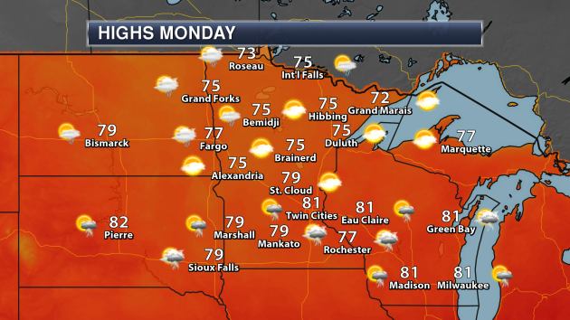
A
few storms are possible Monday, especially across southern Minnesota,
with the potential of a few showers across northwestern and
north-central Minnesota. Highs will mainly be in the 70s across the
state, with the potential of a few areas popping into the 80s.
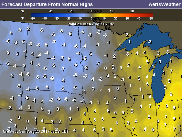
Temperatures
will be slightly below average across most of the state Monday, with
temperatures hovering right around to slightly above average across
eastern portions of Minnesota.
Enjoy
highs in the 80s Monday... as they will be hard to find for the rest of
the week. As we head into next week (and the last few days of August)
we could see highs attempt to return to the low 80s, but otherwise a
very comfortable stretch of weather is ahead temperature-wise.

We
are also keeping an eye on the potential of severe weather Monday
across southern Minnesota. A Slight Risk of severe weather has been
issued by the Storm Prediction Center across parts of far southern
Minnesota (including Rochester), with a Marginal Risk stretching north
to the Twin Cities. Large hail and damaging winds will be the main
threats.
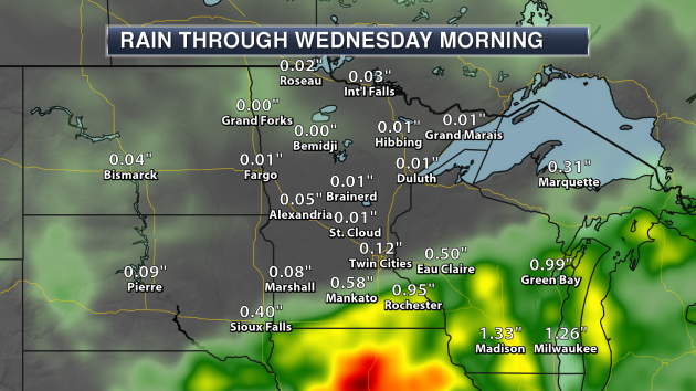
The
heaviest rain through the first half of the week will be across
southern Minnesota, where some areas could receive up to about an inch
of rain. Most of this rain will come through Monday, with a dry Tuesday
expected.
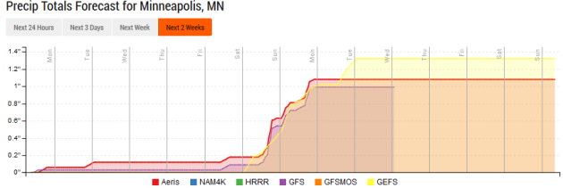
Rainfall
amounts through a good portion of this week will be light in the Twin
Cities - mainly under a quarter inch. As we head into next weekend,
however, rainfall looks to be on the increase, and we could see an inch
or more of rain total by the time we reach this time next week.
________________________________________________
National Weather Outlook
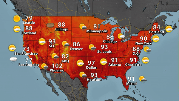
We'll
be watching a stalled front from the Front Range to the Great Lakes
Monday, which will finally start pushing south as a cold front late in
this day. This could help produce some showers and storms across the
region along with a few severe storms across the central U.S.,
especially from Kansas City and Omaha to the Milwaukee and Chicago
areas. Afternoon showers and storms will be possible across parts of the
Southeast as southerly winds bring in tropical moisture. Widespread
monsoonal storms will be possible across the Southwest, with the
greatest potential of flooding rains across parts of central New Mexico.
Highs will be in the 90s as far north as areas like St. Louis and New
York City.
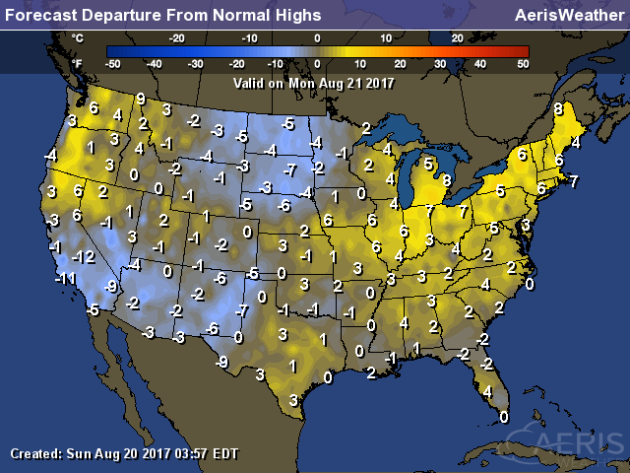
Cooler
than average weather will be observed across parts of the Southwest
into the Northern Plains on Monday, where highs could be a good 5-15
degrees below average. Warmer than average weather will be possible from
the Great Lakes to the Northeast and in parts of the Northwest, with
many other areas hanging within a few degrees of average.
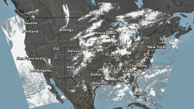
Cloud forecast for 2 PM ET Monday. Credit: AerisWeather/Praedictix.
I
know we are all looking forward to the eclipse Monday! Unfortunately,
the greatest potential of clouds interfering with viewing the eclipse
will be in parts of the Midwest and Southeast, where we could have
numerous clouds. However, for areas with the greatest time in totality
(areas like southern Illinois and western Kentucky) only scattered
clouds are expected.
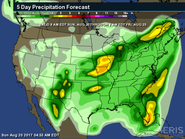
The
heaviest rain through Friday morning is expected across parts of the
central U.S. and in southern Florida, where two or more inches of rain
may fall. Some pockets of heavy rain will be possible from monsoonal
storms in the Southwest as well, especially in Colorado and New Mexico.
________________________________________________
Eclipse Will Change The Weather (For A Few Moments)
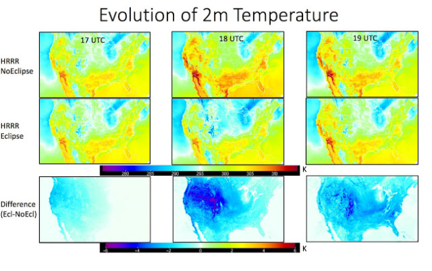
So
with the sun going dark (in some areas) for a few moments Monday, there
will be a little less solar radiation. How will that change the
weather? Cliff Mass has more: "(W)hat
about temperature? Major cooling, with some areas cooled as much as
6°C (11°F)...but not over the Northwest, where the signal is about half
as strong. One major reason is that the eclipse hits earlier on the
West Coast, when solar radiation is weaker, compared to the mid-day
eclipse to the east."
Build A Pinhole Camera To Watch The Eclipse
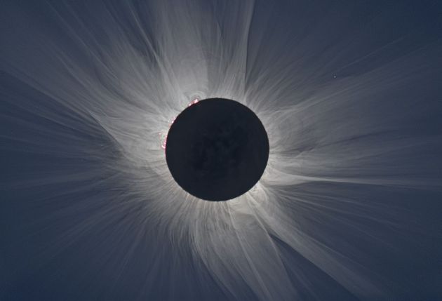
It might be a little late to get a hold of some eclipse glasses, but you can still make a pinhole camera. Popular Science tells you how: "Making
a pinhole camera can be as simple as punching a hole in a piece of
paper: The sun projects through the gap to throw an image onto another
surface (like a second sheet of paper). By adjusting the position of the
pinhole, you can focus the image, although you can't exactly get an HD
picture. Turning a cardboard box that fits over your head into a pinhole
projector will reduce light interference and give you a better closeup,
but that's not an experience you can share with your friends." (Image: M. Druckmüller, NASA)
Enough Corn For The Corn Palace

Good news! With recent rains, the Corn Palace in South Dakota will be able to redecorate their murals. More from Inforum: "A
summer scare for Mitchell's top tourist destination was narrowly
avoided. Despite an excessively dry summer, Corn Palace Director Scott
Schmidt said the city will have enough corn to decorate the nine corn
murals surrounding the World's Only Corn Palace. While the city
voluntarily skipped redecoration of the murals in 2016, it hadn't faced a
drought scare since 2012. And with approximately 275,000 ears of corn
needed for the building, coupled with the dilapidation of the 2-year-old
murals adorning the building, Schmidt was relieved when a recent rain
saved the day."
Drought Taking Longer To Recover From
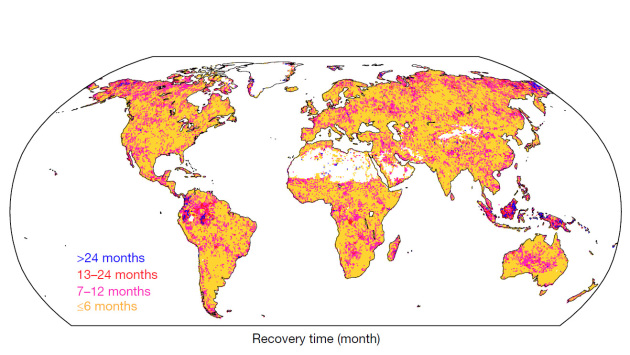
A new NASA study shows that it is taking longer to recover from drought across the world. More from NASA: "As
global temperatures continue to rise, droughts are expected to become
more frequent and severe in many regions during this century. A new
study with NASA participation finds that land ecosystems took
progressively longer to recover from droughts in the 20th century, and
incomplete drought recovery may become the new normal in some areas,
possibly leading to tree death and increased emissions of greenhouse
gases."
Millions Without Food In Ethiopia
Drought and flash floods in Ethiopia have led to a major food shortage in the country. More from the Independent: "Millions
of people in Ethiopia require “immediate life-saving intervention”
after a severe drought and major flash floods have devastated livestock
and crops, the United Nations has warned. At least 7.8 million people
have been receiving emergency food aid since April, up from 5.6 million
at the start of the year, but a further 700,000 people in the country’s
Somali region did not receive supplies “due to resource constraints” and
they are now feared to be on the brink of starvation."
Fewer Apples In Michigan This Year Due To Frost, Drought
Those in Michigan will be able to get apples earlier than average this season, but expect there to be less of them. More from the Detroit Free Press: "While
apples, one of Michigan's most valuable fruit crops, may be early,
don’t expect a bushel buster of a crop this year. Because of frost and
drought damage, according to Fruit Growers News, the Michigan crop is
expected 20 million bushels. That estimate is lower than the
24-million-bushel average according to the Michigan Apple Committee."
Growing Virtual Crops To Help Farmers
Do you want fast-growing or drought-resistant crops? Scientists are trying to come up with that... by growing them virtually. More from Scientific American: "What
if farmers could grow sugarcane in a matter of seconds, not days or
weeks? Scientists are doing just that. Of course, these crops are not
sprouting from soil. Instead they flourish on a computer screen.
Digital plants like these are part of a new movement in agricultural
science called “in silico,” where researchers design highly accurate,
computer-simulated crops to help speed up selective breeding, in which
plants are chosen and replanted to amplify their desirable traits.
Scientists believe the future of farming is not just in fields, but in
graphics, too."
_______________________________________________
Thanks for checking in and have a great Monday! Don't forget to follow me on Twitter (@dkayserwx) and like me on Facebook (Meteorologist D.J. Kayser)!
- D.J. Kayser

Thanks for checking in and have a great Monday! Don't forget to follow me on Twitter (@dkayserwx) and like me on Facebook (Meteorologist D.J. Kayser)!
- D.J. Kayser
No comments:
Post a Comment