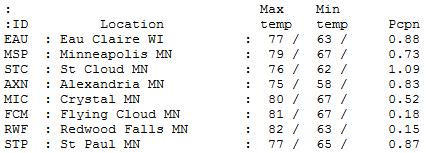
76 F. high temperature at St. Cloud Saturday.
75 F. average high on June 6.
83 F. high on June 6, 2014.
1.08" rain fell at St. Cloud yesterday.
Risk of Bridal Showers"Will
we see showers?" Um, rain showers, bathroom showers, bridal showers?
Please be specific. My amazing daughter-in-law is having her bridal
shower today. Thank you for having it indoors, Tracy.
June is
prime time for grad parties and weddings - cruel irony, since June is,
on average, the wettest month of the year, with the best chance of hail,
high water and cloud to ground lightning.
As a rough rule of
thumb an easterly wind often implies rain or snow. A northwest breeze
traditionally accompanies a rising barometer, with slow clearing and a
diminishing threat of rain.
That will be the case today; a wet start
gives way to lukewarm sun and highs near 80F. An instability T-shower
may sprout later today, especially north and west of St. Cloud, but most
of the time should be dry and suitable for outdoor fun, including St.
Paul's Grand 'ol Day Parade.
A fleeting flash of summer heat is brewing; highs near 90F
Tuesday before cooling down. Another swarm of thunderstorms drops more heavy rain by
Thursday.
We
may break the soggy weekend curse; models hint at showers next Saturday
but a pretty nice Sunday with 70s to near 80F. By late June Minnesota
may be on the edge of a building heat wave.
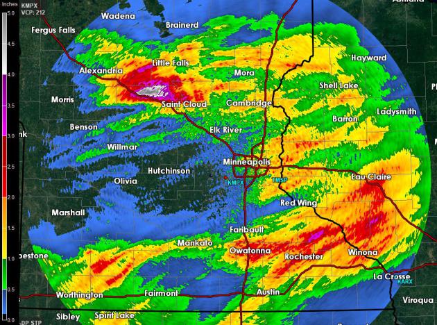
Saturday Soaking.
The heaviest rains last night fell over the eastern suburbs of the Twin
Cities, MPX Doppler radar estimates showing some 1 to 1.5" amounts east
of I-35E, lesser amounts over the western 'burbs. Some 2-3" amounts
soaked a swath from Owatonna and Rochester to Eau Claire, with as much
as 4-5" northwest of St. Cloud.
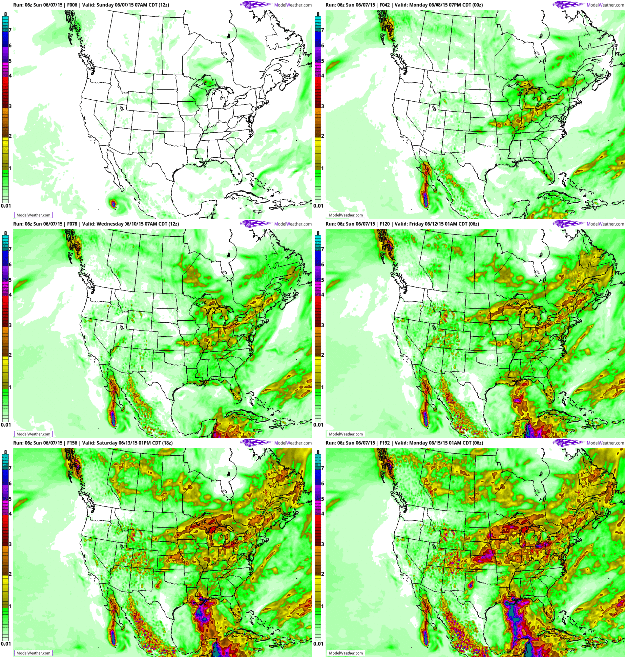
 June Is Living Up To Its (Soggy) Reputation
.
The wettest, most severe month of the year is on track to live up to
expectations. NOAA's GFS guidance prints out some additional 2-4"
amounts for much of Minnesota and the Upper Midwest by next Wednesday.
You can see the projected track of "Blanca" in the eastern Pacific
(missing Cabo) and another plume of tropical moisture extending from
Jamaica into the Gulf of Mexico and New Orleans late in the period.
Animation: AerisWeather.
Flashes of Heat - Interrupted by Downpours.
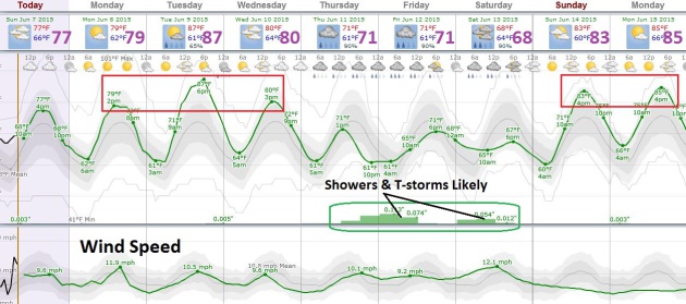
Temperatures mellow into Tuesday before a weak cool frontal passage
drops temperatures and humidity levels the latter half of the week,
setting up a boundary that will support more heavy showers and T-storms
late Thursday into Saturday. It's early but right now Sunday appears to
be the sunnier, nicer, warmer day next weekend. Source: Weatherspark.
Moderately Warm.
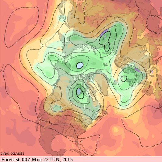
The massive ridge feature predicted earlier for the central Plains may
not materialize by late June; models going back and forth with each new
run. The 500 mb solution for the evening of Sunday, June 21 shows a
fairly active zonal flow; sizzling heat for the southern USA and
Mississippi Valley, but waves of low pressure swept up in the northern
branch of the jet stream, sparking more showers and storms. An active,
wet and potentially severe pattern for Minnesota. Hardly unusual for
June.
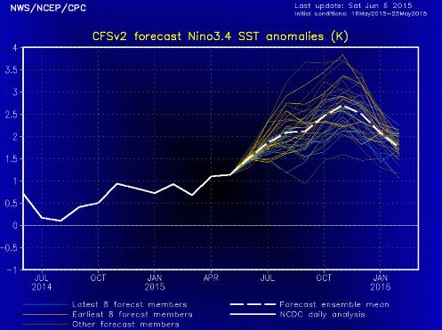
Biggest El Nino Since 1998?
Every new NOAA prediction seems to increase the predicted intensity of
the warming of Pacific Ocean water for later in 2015. El Nino correlates
with warmer weather for most of the USA, and a lesser risk of hurricane
formation in the Carribean and Atlantic due to stronger subtropical
winds aloft. Odds would also favor a longer, warmer autumn. Would I bet
the farm on that? Nope.
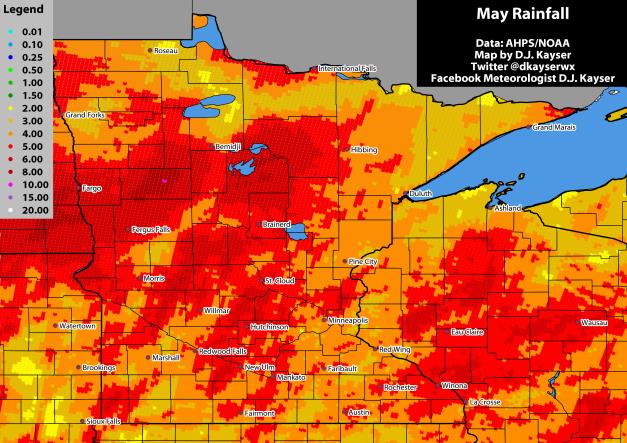
A Very Wet May. Here's a clip from meteorologist
D.J. Kayser's weather blog (who also works with me at AerisWeather): "
After a dry start to the year (we covered that last month here),
May really ramped up the precipitation across the state of Minnesota,
with many areas picking up much needed rainfall to help the drought
situation and help get some moisture into the crop fields. However, some
of it was too much, as there were reports of “downed out portions of
fields” according to the USDA crop report that was issued for the week ending May 24th. According to Minnesota climatologist Mark Seeley, this May will likely be one of the top fifteen wettest Mays on record for the state, and is the fifth straight May with above average rain..."
June 2015: Cold Start, Followed By Rain.
Soil moisture is now adequate across most of Minnesota for farming and
gardening - let's hope we don't have a June as wet as 2014 (wettest,
statewide, in the state's history). Here's an excerpt from Dr. Mark
Seeley at
Minnesota Weather Talk: "
The
month of June started with cold temperatures earlier this week. On
June 1st many northern cities were visited by frosty temperatures
including International Falls, Bigfork, Cloquet, Hibbing, Crane Lake,
and Gunflint Lake. It was as cold as 37°F at Preston (Fillmore County)
in southern Minnesota but no frosts were reported in that section of the
state. A few observers reported record low temperatures for the date
including: 29°F at Ely, 27°F at Floodwood, 26°F at Orr, 25°F at
Embarrass, and 24°F at Togo (Itasca County), also the coldest
temperature in the nation on June 1st this year..."
Most of Minnesota Is Drought-Free.
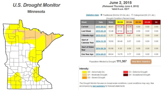
What a difference a week makes. A month too. In just the last week the
percentage of Minnesota in moderate drought has fallen from 24% to 12%.
Last week 87% of the state was abnormally dry; now that number is down
to 51%. As you can see on the
U.S. Drought Monitor map
above most of the state, especially central and southern counties now
have sufficient soil moisture. Amazing how fast the pattern turned.
What's The Difference Between "Partly Cloudy" and "Mostly Sunny"? A question that comes up all the time - here's an excerpt of a good explainer at
Gizmodo: "...
Mostly
Sunny” and “Partly Cloudy” are apparently interchangeable, and apply
when the OCC is between 26% and 50%.”Partly Sunny” and “Mostly Cloudy”
can also be synonyms, when the OCC is between 51% and 69%, although
“Mostly Cloudy” can be applied for OCC up to 87%. At an OCC of 88% and
above, the sky is considered “Cloudy” or “Overcast...”
Ray Kurzweil: Humans Will Be Hybrids by 2013.
Imagine Siri as a permanent inhabitant of your brain, now super-charged
by the cloud. She's now available 24/7 to help you - or judge you - or
track you. I'm sold! Here's an excerpt from
CNN Money: "...
Kurzweil predicts that humans will become hybrids in the 2030s. That means our brains will be able to connect directly to the cloud,
where there will be thousands of computers, and those computers will
augment our existing intelligence. He said the brain will connect via
nanobots -- tiny robots made from DNA strands. "Our thinking then will
be a hybrid of biological and non-biological thinking," he said..."
TODAY: Wet start, then lukewarm sun. Winds: NW 15. High: near 80
SUNDAY NIGHT: Clearing and mild. Low: 63
MONDAY: Warm sun, T-showers over Wisconsin. High: 82
TUESDAY: Hot sun, late-day thunder? Wake-up: 65. High: 89
WEDNESDAY: Plenty of sunshine, less humid. Wake-up: 66. High: 82
THURSDAY: Showers and storms, heavy rain possible. Wake-up: 62. High: 76
FRIDAY: A few T-storms linger. Wake-up: 61. High: 77
SATURDAY: Drier, intervals of sunshine. Wake-up: 62. High: 79
Climate Stories....
Pope Francis The Chemist Should Give Congress a Science Lesson. TIME Magazine has the Op-Ed; here's an excerpt: "...
Pope
Francis defies the liberal-conservative divide that shapes Congress,
and given his straightforward, pull-no-punches approach, he will likely
challenge both Democrats and Republicans to reject the “throwaway culture”
that he has repeatedly denounced during his papacy. In particular, the
pope is likely to challenge Republicans to accept the reality of climate
change and to support measures that would protect the environment.
Meanwhile, he’s likely to challenge Democrats on abortion, as he treats
the issue as integral to social justice and the defense of human rights..." (File Photo: AP)
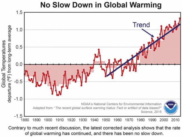
Here's Why The Global Warming Hiatus Might Not Exist.
Climate Central has an explanation; here's an excerpt: "
The global warming hiatus
— a decade-plus slowdown in warming — could be chalked up to some
buoys, a few extra years of data and a couple buckets of seawater. That’s the finding of a new study published on Thursday
in Science, which uses updated information about how temperature is
recorded, particularly at sea, to take a second look at the global
average temperature. The findings show a slight but notable increase in
that average temperature, putting a dent in the idea that global warming has slowed over the past 15 years, a trend highlighted in the most recent Intergovernmental Panel on Climate Change report..."



No comments:
Post a Comment