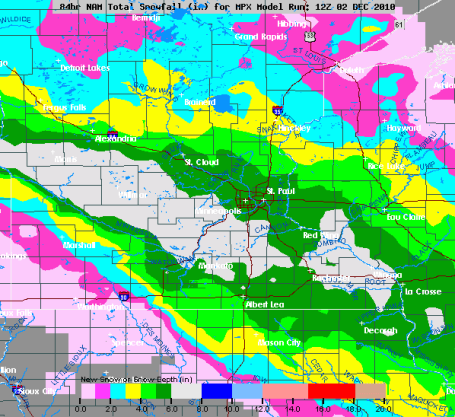
* 12Z NAM/WRF model data prints out .35" for STC Friday PM hours. That's a little less than last night's run, which printed out .56". With a snow/rain ratio close to 20/1 that could still translate into 3-6" for the St. Cloud area, more south of town, less north of STC. I still feel (reasonably) comfortable saying 3-6" of light, fluffy, powdery snow during the PM hours tomorrow as an overall range for the St. Cloud metro area.
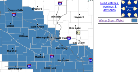
Winter Storm Watch. The local NWS office has issued a watch for most of central/southern MN - the metro area on the northern fringe of the watch area. A watch means 6"+ amounts possible during a 24 hour period. No mix of rain/ice with this storm - the atmosphere will be cold enough for all snow this time.
* Temperatures will be close to 20, which doesn't bode well for conditions on area highways. The chemicals MnDOT puts down work much faster when the mercury is close to 30-32 F. But at 20 F. these chemicals don't work nearly as quickly or effectively. Even the freeways may be snow-covered and icy by Friday evening. Plan on leaving 3 to 5 times more time to get around late in the day tomorrow.
How Much? The 12Z run backs off on the snow amounts (slightly). No more band of 8-10" showing up, clipper maxes out at 6-7" running from Alexandria and Willmar through western/southern suburbs of MSP. Here is the latest NAM/WRF guidance - hinting at some 3-6" amounts of light, powdery snow across much of the St. Cloud metro, closer to 6-7" just south, toward Willmar and Glencoe. The heaviest band of snow will PROBABLY set up just to our south, but this still looks like a "plowable" snow event for much of central MN.


No comments:
Post a Comment