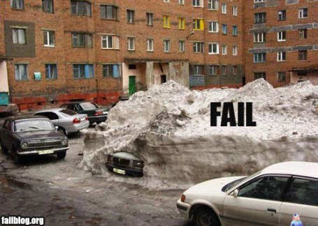
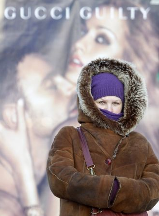
Let's Move To Minnesota! Hey, it's not so bad. How long can you hold your breath? No such thing as bad weather - just inappropriate clothing choices.
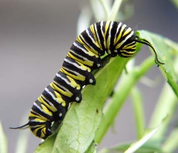
Caterpillars Predict Severe Winter. From the Fox affiliate in Washington D.C.: "
HAGERSTOWN, Md. - A weather prognosticator for The Hagers-Town Town and Country Almanack says the upcoming winter is going to be cold, snowy and severe. How does he know? Caterpillars. Almanack Weather Prognosticator William O'Toole looked at the markings on pictures of wooly bear caterpillars submitted by area residents for an almanac contest in order to make his prediction. The markings on the caterpillar are believed to indicate how severe or mild a coming winter will be."
The complete story is
here.
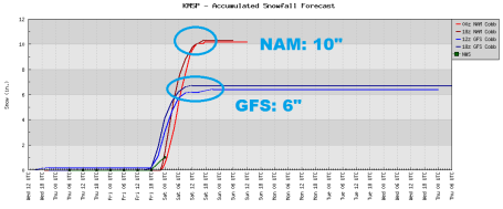
Friday: Another "Burst" of Snow? Latest NAM models showing 10" snow, GFS closer to 6" for STC. Southern storms bring their own set of complications: will they pull enough warm air north for rain/ice, vs. snow? Will a surge of dry air (the "dry tongue") get tangled up in the storm's circulation and lower amounts. But Friday's clipper will race in from the west-northwest, dropping a relatively narrow band of moderate/heavy snow. It's too early to know if St. Cloud will be in this axis of significant snow, but the models are looking impressive (now). Whether they'll look this impressive Friday morning is another question altogether. The last storm the models looked VERY impressive up until 24 hours before the precipitation started, and then backed off dramatically on snowfall amounts for the St. Cloud area. Remember? St. Cloud picked up 1.3" while Brooten and Belgrade saw 6-7". Maddening. This time around: the lowest mile of the atmosphere will definitely be cold enough for ALL SNOW. No ice or rain this time. The question is the track. Will it shove the snow south/west of the MN River Valley or will it push the heaviest amounts right over the cities? Hopefully the 12Z and 18Z run today will shed more light on whether this is another near-miss, or the real deal. Best case (or worst case if you have an intense dislike for snow?). Some 10" amounts close to home (especially south of St. Cloud), light, powdery, fluffy snow with temperatures in the upper teens and low 20s, potentially prone to blowing and drifting.
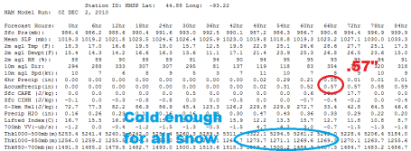
. I know you're probably sick of hearing that word...p-p-p-plowable. Get used to it. The latest NAM model prints out .57" (with a 10/1 ratio of snow/rain that would translate into a cool 6"). The problem is: with temperatures in the low 20s that ratio may be closer to 15/1, even 20/1, which would translate into more than 10". I'm still not convinced the heaviest snow bands will set up directly over the Twin Cities - it may be more of a heavy snow event south/west of the Minnesota River Valley. Bottom line: it's still too far off to know exactly where the heavier snow bands will set up, but there is certainly a strong (and growing) potential for enough snow to shovel and plow from midday Friday through Saturday morning. Right now it looks like the heaviest snow should fall Friday night. I've circled the 1000-850 mb "thicknesses", which is equivalent to temperature in the lowest 3,000 feet of the atmosphere. A value of 1300 is "critical", the rain/snow line. Values are expected to be in the 1269 to 1273 range, definitely cold enough for ALL SNOW.
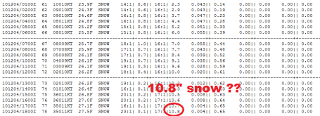
It's too early to get excited (or depressed). This data (from Iowa State University) factors in a snow ratio of close to 20/1 (20" of light, fluffy, powdery snow for every 1" of liquid). So .6" liquid might translate into close to 11" of snow - in a perfect word. But it's still too early to know (for sure) if the heaviest snow bands will set up over St. Cloud, or shift farther south/west, running from Montevideo and Willmar to Mankato, which is a distinct possibility. Hopefully the models on Thursday will crystallize around a final solution and our confidence levels will increase. Bottom line: a shift of 50-75 miles in the track of Friday's clipper will probably make the difference between a couple inches, and as much as 6-10" of accumulation. Right now it appears the axis of heaviest snow will set up just south/west of St. Cloud, but a slight northward shift to the track of the clipper could bring the heaviest burst of snow right over central Minnesota.
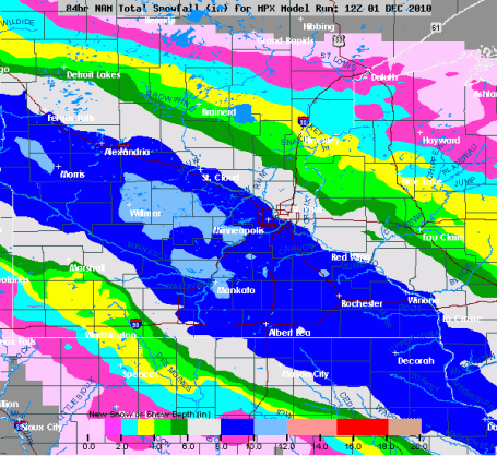
Snowy Bulls-Eye? Right now the NAM/WRF model shows the axis of heaviest snow setting up right over the metro area, running from Morris and Willmar into the southern/western suburbs to Mankato and Rochester, a 75 mile wide band of 8"+ amounts. We'll see. It's by no means a slam-dunk - there's still a good chance the heaviest amounts will stay south/west of the MN River, but there's little doubt we'll see enough snow to shove/plow, a light, powdery, fluffy snow that will be relatively easy to get off your driveway - but with temperatures in the upper teens to low 20s even major highways may become snow-covered Friday night - expect a skating rink out there after dark tomorrow.
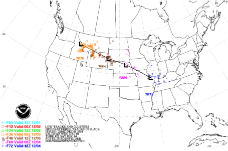
Big Time Clipping? The track of Friday's storm makes me nervous (then again, everything makes me nervous these days). It's fairly far south and west - no question we'll have a deep enough layer of cold air for snow. No question about that. But with a track from Omaha to St. Louis I'm concerned that the heaviest snow bands may set up over far southern MN, we may just be on the northern fringe of the most significant snow. That said, not sure how we see less than 2 or 3", but there's little doubt the best chance of 6"+ will come south/west of St. Cloud.
* The last time we saw above-average snowfall for a winter season here in the Twin Cities? The winter of 2003-2004, when just over 66" fell (average is closer to 50" for the last 30 winters). At the rate we're going I think we may see the first above-average winter for snow in 7 years. Stay tuned.
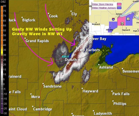
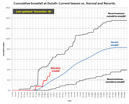
"Gravity Waves". Duluth has picked up 36" of snow so far this winter season, 18.6" more than normal, to date. I'm discovering that much of the (enhanced) snow that is usually attributed to "lake effect" is actually the result of "gravity waves", Rossby waves setting up because of the differences in terrain in the Duluth. With a storm passing off to the south and east of DLH residual moisture + a 1,200 foot difference in elevation can create these "waves" of heavy snow - the most intense squalls often setting up just south/east of downtown Duluth over extreme northwestern Wisconsin. Amazing stuff. WeatherNation meteorologist Todd Nelson has more on gravity waves on the Ham Weather blog
here.
"Above Average". Check out the snow trend lines for Duluth, running well above average. Check out the details from the Duluth NWS office
here.
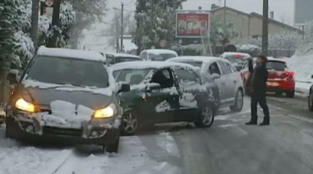
Crippling Storms. We aren't the only ones getting an early dose of the Winter Blues. Much of central Europe is shut down by high winds, heavy snow and ice - resulting in hundreds of traffic accidents and hundreds of delays and cancellations at airports from London to Frankfurt. Genva, Switzerland picked up 10" snow in 24 hours.
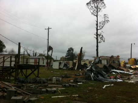
Tornado Aftermath. This was the scene in Starkville, Mississippi after a swarm of tornadic storms swept across the region Tuesday, leaving behind a trail of destruction which may run into the tens of millions of dollars. The EF-4 tornado that hit Winn Parish, Louisiana Monday was the first "4" level tornado since 1991, according to Severe Studios.
* So far in 2010 a total of 13 EF-4 tornadoes have been reported, nationwide. That's the most since 1999.
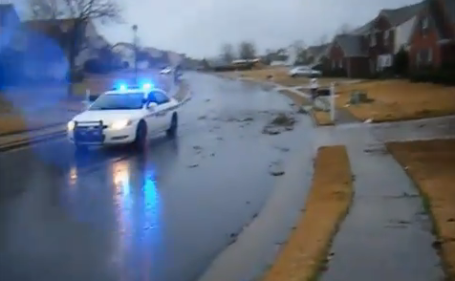
Buford, Georgia Tornado. This YouTube
footage shows a dazed storm survivor walking down his street, surveying the damage after severe winds buffeted his neighborhood. It may have been straight-line winds (or a small tornado). Much of the Deep South is cleaning up from a rare late November - early December severe storm outbreak. A tornado watch was posted for the Buford area, but (apparently) no warnings were in effect when the tornadoes struck. Atlanta picked up over 2" of rain from this system, a 24 hour record, with numerous reports of flash flooding.
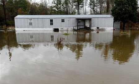
Severe Flooding. This was the scene in Morgan County, Alabama, after a month's worth of rain fell in less than 36 hours, producing severe flash flooding. An
article by the AP summarizes the damage path of this intense early December storm: "
Winds whipped across the East Coast on Wednesday as the region wrestled with yet another day of heavy rain and severe weather that knocked out power to thousands, slowed commuters and caused widespread damage.Tornado watches were issued for parts of the Virginias, and officials in Washington, D.C., handed out sandbags to protect homes from flooding. Thousands of customers were without electricity in the mid-Atlantic area and New York, and some schools delayed openings. The storm system has brought suspected tornadoes to several Southeastern states since Monday, from Louisiana to South Carolina. The system was headed toward the Northeast, with colder air turning the rain into snow."
"Electrosmog" Is WIFI Harmful To Humans? One more thing to worry about. Just about the time I'm (finally) happy with my high speed wireless Internet, along comes
this story from the U.K.'s Daily Mail. An excerpt: "
Research in the Netherlands suggested that outbreaks of bleeding bark and dying leaves which have blighted the country’s urban trees may be caused by radiation from the Wi-Fi networks now so integral to life in offices, schools and homes. As a qualified electronics engineer, I am not surprised by such findings. I have long been concerned about the harmful effects of the electro-magnetic radiation emitted not only by Wi-Fi devices but many other common modern gadgets, including mobile and cordless phones, wireless games consoles and microwave oven Much though I love trees, and worrying though I find this research, what really unnerves me is the effect these electro-magnetic fields (or EMFs) are having on humans, surrounding us as they do with a constant cloud of ‘electrosmog’.
Has NASA Found Alien Life? Stop the presses. This could be a game-changer. Life on Mars? Intelligent life on Earth? PC Magazine has more
details: "NASA has incited the excitement of space camp alums everywhere with the announcement of a Thursday press conference that could discuss findings of life beyond earth. "NASA will hold a news conference at 11 a.m. PST on Thursday, Dec. 2, to discuss an astrobiology finding that will impact the search for evidence of extraterrestrial life," NASA said in a Wednesday statement. "Astrobiology is the study of the origin, evolution, distribution, and future of life in the universe."
Paul's SC Times Outlook for St. Cloud and all of central Minnesota:
TODAY: Intervals of sun, good travel. Winds: NW 10. High: 18
THURSDAY NIGHT: Partly cloudy and cold. Low: 4
FRIDAY: Dry start, no problems for the AM commute. Light snow develops by late afternoon. High: 20
FRIDAY NIGHT: Snow likely, potentiall tricky travel. Potential for 4-8" snow, more south/west of STC. Low: 18
SATURDAY: Snow tapers, "plowable" amounts early in the day - better travel by afternoon with some PM sun possible. High: 21
SUNDAY: Sun returns - numbing breeze. High: 18
MONDAY: Blue sky, Arctic fun!. High: 15
TUESDAY: Cold and quiet, more like January. High: 18
WEDNESDAY: Still waiting on a warm front. Mix of clouds and sun, good travel weather. High: 21
A Real Winter
Does this latest cold, snowy spell disprove the fact that our atmosphere is slowly warming over time? No. Every time it snows, every time a cold front arrives, some people cry "where's your global warming now?" They don't (or won't) grasp the fundamental difference between weather and climate. Weather is CNN Headline News. Climate is the History Channel.
NOAA and NASA insist that, worldwide, 2010 will tie 1998 for the warmest year on record, globally. For the sake of my kids I hope the scientists are wrong. Time will tell.
Brian Westberg wants to know the difference between the winter solstice and "meteorological winter." Historically the coldest 90 day period starts December 1. So in reality, winter really kicks off in early December, not the 21st. No kidding?
No travel problems today, but computer models show another "plowable" snow moving in Friday PM hours, the best chance of 4-8" south and west of the Twin Cities by Saturday morning. It may be a close call. If you plan on traveling late Friday or early Saturday check the blog for the latest. Another Arctic treat arrives behind the storm next week; at this rate odds favor a VERY "white" Christmas this year. Count on it.
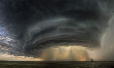
"Supercell". Sean R. Heavey captured this incredible photo of a supercell thunderstorm over Montana - a classic, textbook example of the kind of rotating "mesocyclone" that can go on to produce large hail and tornadoes. I don't think I've ever seen a supercell this amazing - click
here for more details.
For Russia, Global Warming Benefits Outweigh Risks. Yes, there will be benefits to a warmer world, no question. An excerpt from an
article in the Moscow Times: "
Global warming in the next 40 years will allow Russian authorities to save on central heating, increase agricultural production and extend sea navigation in the north, a leading Russian climatologist told a Russian-German conference Wednesday. But authorities will have to fork out money to reconstruct several big Siberian and Far Eastern cities to prevent them from collapsing as a result of a warmer climate, Vladimir Klimenko, head of Laboratory of Global Power Engineering Problems at the Moscow Power Engineering Institute told the conference co-organized by Alexander von Humbolt Foundation. However, "the reduction of heating alone outweighs all the negative results [of the global warming] by many times," Klimenko said. If the money saved through reducing heating "is spent sensibly, then something can be achieved," he said."
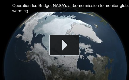
Monitoring Global Warming Over Antarctica. NASA is keeping a close eye on what's happening over Antarctic tapping the power of satellites. Here is an excerpt from an
article at smartplanet.com: "
In the past couple of years, massive chunks of ice have broken off of Antarctica, stoking fear that the polar ice caps — the North and South poles, Arctic and Antarctic — might one day completely collapse. Vulnerable and rapidly changing, Antarctica alone is already contributing a third of the total rise in global sea level. Needless to say, monitoring the state of the ice caps is particularly important. That’s why NASA is keeping a close eye on the polar ice caps. But this time, the agency is doing so right here from earth. SmartPlanet interviewed Steve Hipskind, chief of NASA’s AMES Earth Sciences division, about NASA’s mission, called Operation Ice Bridge.
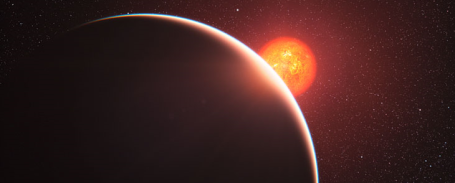
First "Super-Earth" Atmosphere Analysed. From an
article at eso.org: "
The atmosphere around a super-Earth exoplanet has been analysed for the first time by an international team of astronomers using ESO’s Very Large Telescope. The planet, which is known as GJ 1214b, was studied as it passed in front of its parent star and some of the starlight passed through the planet’s atmosphere. We now know that the atmosphere is either mostly water in the form of steam or is dominated by thick clouds or hazes. The results will appear in the 2 December 2010 issue of the journal Nature."




No comments:
Post a Comment