35.1" for the winter so far in the Twin Cities
1/10th of an inch of snow reported Monday in the metro area.
25 F. High on Monday, 6 degrees above average for January 24. Record: 56 (1981)
8" average February snowfall in St. Cloud.
10" average March snowfall in St. Cloud. (March is now the second snowiest month, second to January, when an average of 13" falls.
2.8" average April snowfall in St. Cloud.
20 F. average high on February 1 in the metro area.
32 F. average high on February 28 in the metro area.
47 F. average high on March 31 at STC.
Average temperatures in St. Cloud begin to (finally!) trend upward in late January. Actual temperatures for 2011 are below. To see specific weather for any day in St. Cloud since 1999 click
here.
 Garage Your Snowblower
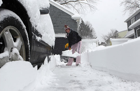
. No significant snowfalls are in sight through next week. In fact I don't see enough snow to shovel or plow looking out the next 2 weeks.
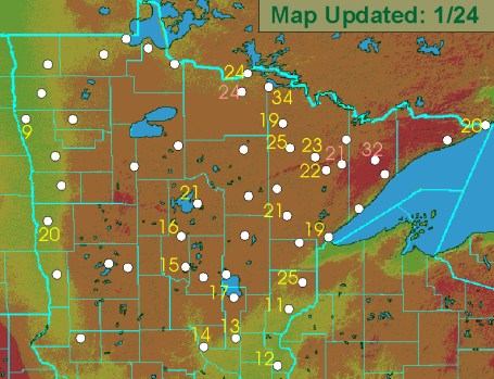
Snowcover Up North. John Dee has created a great
site with updated snowfall totals across the Upper Midwest. Click snowcover, then click on Minnesota to see the latest numbers. 17" at Brainerd, 21" Walker, 19" Duluth and 32" up on the Gunflint Trail.
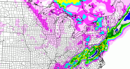
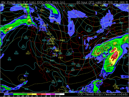
Predicted Snowfall Through Thursday Night At Midnight. A coastal storm may drop a "plowable" amount of snow across Virginia, maybe a few inches for Washington D.C. - no major snow events for Minnesota into next week. That's right, we're getting an extended break from the flakes.
Another Shot? Let's enjoy this weeks 20s (and possible low 30s) before getting too worked up about the long-range outlook. But in the spirit of full disclosure the (GFS) model is pulling another Arctic airmass south of the border after February 5 or so. The good news - it should be relatively brief, maybe 2-3 nights below zero. We're gaining over 2 minutes of daylight every day now - subzero weather will become more rare as we sail through February. But looking out the next 2-3 weeks I don't see any major shift or breakdown in the pattern (the negative phase of the NAO, the North American Oscillation), that would pull consistent warmth into Minnesota from the Pacific. We're in a cold run, and with a few exceptions (this week, the end of next week) will see colder than average temperatures into at least mid February. A correction down the road? Possibly - I just don't see it yet.
Snow For D.C. and Philadelphia By Wednesday? Latest models take a southern storm out to sea, but not before dumping a few inches of slushy snow (mixed with ice and rain) on the Carolinas, Virginias, and possibly D.C. to Philadelphia. It looks like New York and Boston may miss out on any significant precipitation this time around.
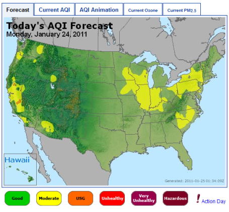
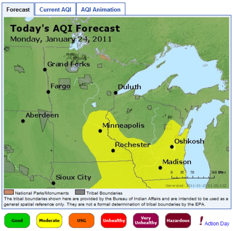
Midwinter Smog? Relatively light winds, coupled with frequent inversions during the winter months (warmer air aloft trapping polluted air near the ground) can create high levels of particle pollution and ozone, even in January. The latest AQI, Air Quality Index for Minnesota and Wisconsin is here. A few highlights from the EPA's airnow.gov
site: "
Today, light to moderate southwesterly winds ahead of an approaching weak cold front will transport pollutants and moisture into the Twin Cities, increasing particle production and resulting in Moderate AQI levels. Wednesday, winds will shift to north-northwesterly behind the departing weak cold front, dispersing pollutants and lowering AQI levels to Good."
Scientists Perplexed By Weird Weather Pattnerns. New York City had the hottest summer on record in 2010. Two of New York City's largest snowstorms on record struck the city last year, including the 2 foot storm that disrupted travel after Christmas. While much of America, Europe and Asia shivers, parts of Canada and Greenland are experiencing record warmth, temperatures as much as 15-20 F. warmer than average. From an
article at the New York Times: "
Judging by the weather, the world seems to have flipped upside down. For two winters running, an arctic chill has descended on Europe, burying that continent in snow and ice. Historic blizzards last year afflicted the United States' mid-Atlantic region. The Deep South has endured unusual snowstorms and severe cold this winter, and a frigid Northeast is bracing for what could shape into another major snowstorm at midweek. Yet, while people in Atlanta learn to shovel snow, the weather 2,000 miles to the north has been freakishly warm the past two winters. Temperatures in northeastern Canada and Greenland ran as much as 15 or 20 degrees above normal in December. Bays and lakes have been slow to freeze. Iqaluit, capital of the remote Canadian territory of Nunavut, had to cancel its New Year's snowmobile parade. Deputy Mayor David Ell said people in the region had been looking with envy at snowbound American and European cities. "People are saying, 'That's where all our snow is going!' " he said. The immediate cause of the topsy-turvy weather is clear enough. A pattern of atmospheric circulation that tends to keep frigid air penned in the Arctic has weakened during the past two winters, allowing big tongues of cold air to descend far to the south, while masses of warmer air have moved north. The deeper issue is whether this pattern is linked to the rapid changes that global warming is causing in the Arctic, particularly the drastic loss of sea ice. At least two prominent climate scientists have offered theories suggesting it is. But many others are doubtful, saying the recent events are unexceptional, or that more evidence over a longer period would be needed to establish a link."
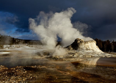
Yellowstone Has Bulged As Magma Pocket Swells. A recent
article from nationalgeographic.com suggests increasing concern on the part of volcanologists about what's going on beneath this majestic national park, site of one of the world's largest super-volcanoes: "
Yellowstone National Park's supervolcano just took a deep "breath," causing miles of ground to rise dramatically, scientists report. The simmering volcano has produced major eruptions—each a thousand times more powerful than Mount St. Helens's 1980 eruption—three times in the past 2.1 million years. Yellowstone's caldera, which covers a 25- by 37-mile (40- by 60-kilometer) swath of Wyoming, is an ancient crater formed after the last big blast, some 640,000 years ago. Since then, about 30 smaller eruptions—including one as recent as 70,000 years ago—have filled the caldera with lava and ash, producing the relatively flat landscape we see today. But beginning in 2004, scientists saw the ground above the caldera rise upward at rates as high as 2.8 inches (7 centimeters) a year. (Related: "Yellowstone Is Rising on Swollen 'Supervolcano.'") The rate slowed between 2007 and 2010 to a centimeter a year or less. Still, since the start of the swelling, ground levels over the volcano have been raised by as much as 10 inches (25 centimeters) in places. "It's an extraordinary uplift, because it covers such a large area and the rates are so high," said the University of Utah's Bob Smith, a longtime expert in Yellowstone's volcanism."
Your Lying Eyes - Can This Be Happening. Nothing like great optical illusions on a Tuesday! Seeing is believing - ot not. From an
article at NPR: "
You have two eyes. Each eye sees a slightly different world. (Put a finger in front of your face, switch from one eye open to the other and that finger will shift, just a little bit.) But rather than walk around all day seeing in double vision, your brain pulls the world back into one-ness. Brains decide what we see. Kokichi Sugihara knows this better than anyone. He makes videos that trick your brain into seeing things that you know, you absolutely know, can't happen. And yet — "
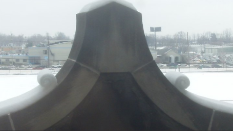
What The Heck Caused This? These are called "snow-rollers", usually found in fields. This is the first time I saw this phenomenon on a building (in this case a
school). Strange, but pretty cool.
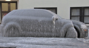
Audi "Icicle". Not what you want to see when you walk out of an NFL playoff game. The
story from WPIX-TV in New York: "
The owner of the car, who gave only his first name -- Pete -- said he parked his car Friday evening and that at some point during the weekend the leak began. As car after car splashed through the standing lake, layer upon layer of ice formed on Pete's car. After watching his beloved Jets lose lose the AFC Championship game Sunday, Pete got up and left his house Monday -- only to find his car turned into an ice sculpture. And it got worse after Pete used a hammer and screwdriver to free up enough ice to open one door. "I ran the heat in the car, then just the pressure alone and the cold temperature difference made it really brittle and it broke like it was a piece of ice and just splattered everywhere," Pete said."
 Paul's SC Times Outlook for St. Cloud and all of central Minnesota:
TODAY: Flurries taper, peeks of sun. Winds: SW 8-13. High: 18
TUESDAY NIGHT: Mostly cloudy - not quite as cold as recent nights. Low: 7
WEDNESDAY: More clouds than sun, quiet. Temperatures close to "average". High: near 20
THURSDAY: Some sun, noticeably "milder". High: near 30
FRIDAY: Dripping icicle early? Early thaw, then gusty and colder. High: 32 (falling by afternoon)
SATURDAY: Numbing wind returns, few flakes. Low: 6. High: 11
SUNDAY: Subzero start, blue sky. Low: -11. High: 4
MONDAY: Clouds increase, not quite as cold. Low: -10. High: 11
Nice To Be "Average"
To err is human. If you're a meteorologist - it's expected. A few days ago I (incorrectly) stated that "winter is running 4% warmer than average, based on heating degree data." What I MEANT to say is that the "heating season" (going back to autumn) is running 4% warmer than average. December was 2.3 F colder, so far January is 3.5 F colder. So, without question, winter is most definitely colder than average, whether you start from the beginning of "meteorological winter" (December 1), or the Winter Solstice on Dec. 21.
Meteorological winter HAS been colder, and the 55"+ of snow makes it seem even more forbidding. It's already the snowiest winter in 7 years, and you'll be happy to hear that we are now past the halfway point of winter. No mega-storms in sight. We catch a break this week, a string of 20s, freezing possible by Thursday and Friday as Pacific air (temporarily) dislodges the Arctic blocking pattern swirling over the eastern 2/3rds of America.
Parts of northeastern Canada and Greenland are running 20 degrees warmer than average; a milder Arctic has pushed the "polar vortex" thousands of miles south, spinning up bitter fronts & big storms here. We're seeing strange new air & water circulations at northern latitudes.
Prediction: Mega-Potholes. I swear they're testing tanks on Highway 7. The freeze-thaw cycle sparks more craters this week. Beware.
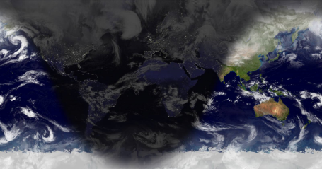
Sunlight Map. Great news: daylight in the Twin Cities today will be exactly 2 minutes and 17 seconds longer than it was yesterday. Within 1 week the average temperatures begin to trend upward again, for the first time since late July. Click
here to see where daylight and darkness is - right now - across planet Earth.
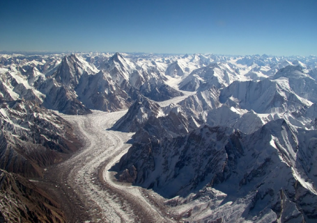
Himalayan Glaciers Shrinking, With One Exception. From a
post at wired.com: "
An important portion of the Himalaya’s glacier cover is currently stable and, thanks to an insulating layer of debris, may be even growing, a new study finds. The study’s conclusion contradicts a portion of the 2007 Intergovernmental Panel on Climate Change report that had to be retracted last year because it could not be substantiated.
Though the IPCC report stated that the risk of the region’s glaciers “disappearing by the year 2035 and perhaps sooner is very high,” the new study finds that ice cover is stable in the Karakoram mountains, a northern range that holds about half of the Himalaya’s store of frozen water. That’s not to imply that water reservoirs on what’s often called the roof of the world aren’t under stress. Throughout most Himalayan ranges, roughly 65 percent of the studied glaciers were shrinking, Dirk Scherler of the University of Potsdam, Germany, and his colleagues report in the January 23 Nature Geoscience. But in Karakoram, 58 percent of studied glaciers were stable or slowly expanding up to 12 meters per year."
What Impact Would "Solar Dimming" Have On Earth's Weather? Call me crazy, but I believe nothing good can come out of tinkering with the atmosphere - more than we already have (inadvertently). From an
article at R&D Magazine: "
Solar radiation management projects, also known as sun dimming, seek to reduce the amount of sunlight hitting the Earth to counteract the effects of climate change. Global dimming can occur as a side-effect of fossil fuels or as a result of volcanic eruptions, but the consequences of deliberate sun dimming as a geoengineering tool are unknown. A new study by Dr Peter Braesicke, from the Centre for Atmospheric Science at Cambridge University, seeks to answer this question by focusing on the possible impacts of a dimming sun on atmospheric teleconnections. Teleconnections, important for the predictability of weather regimes, are the phenomenon of distant climate anomalies being related to each other at large distances, such as the link between sea-level pressure at Tahiti and Darwin, Australia, which defines the Southern Oscillation. "It is important that we look for unintended consequences of any sun dimming schemes," said Braesicke. "We have to test our models continuously against observations to make sure that they are 'fit-for-purpose', and it's important that we should not only look at highly averaged 'global' quantities." Dr Braesicke's team believes that the link between tropical temperatures and extra-tropical circulation are well captured for the recent past and that the link changes when the sun is dimmed."
The Economics Of Global Warming. Here is an excerpt of a recent Newsweek
article: "
The real global challenge facing us will be organizing to reduce carbon emissions and provide help to poor countries coping with climate change. The worst, but not the most likely, consequences of climate change could be rising sea levels: there is grounded ice in Antarctica that, if loosed from its moorings, is worth five or six meters of sea level, enough to sink Stockholm, Manhattan, or London, or to oblige them to build levees to escape inundation, and to oblige millions of Bangladeshis and others to abandon their homes and workplaces and to migrate. (Levees cannot save Bangladesh; they leave no escape for the freshwater floods that need to reach the ocean.) The most likely consequences of climate change will be severe impacts on food production in the developing world. We can worry about urban heat waves, polar bears, and forest fires, but the worst effects are almost certainly going to be on food production in the poor countries, where half or more of the population depends on growing its own food."
Less Is More For Cost-Efficient Wind Farms. Placing wind turbines too close together can have a big impact on the amount of wind power a farm can harvest on any given day, research shows. An
article from gizmag.com: "
While there are increasing numbers of large wind farms being built around the world, many of these projects are underperforming and not producing as much power as expected. New research suggests the reason could be that the wind turbines are being placed too close together. The researchers say that spreading the turbines out will result in a more cost-efficient wind farms and they’ve come up with a formula through which the optimal spacing for a large array of turbines can be obtained. The newest wind farms, be they on or offshore, typically use turbines with rotor diameters of around 300 feet (91 m), which are typically spaced about seven rotor diameters apart. Charles Meneveau, a fluid mechanics and turbulence expert at Johns Hopkins University, working with Johan Meyers, an assistant professor at Katholieke Universiteit Leuven in Belgium, conducted research that indicates placing the wind turbines more than twice as far apart as current layouts – 15 rotor diameters apart – results in more cost-efficient power generation."


No comments:
Post a Comment