18.8 feet: predicted crest of the Mississippi River in St. Paul by the middle of next week (nearly 2 feet above major flood stage).
*
Nighttime lows predicted to stay below freezing through at least next Thursday, slowing the rate of snow melt.
*
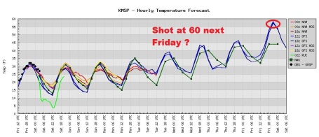
Gradual warming trend next week: 40s likely, 50 by next Thursday, GFS hints at 55-60 F. readings next Friday.
*
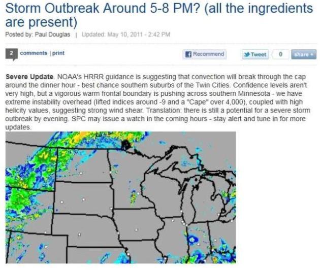
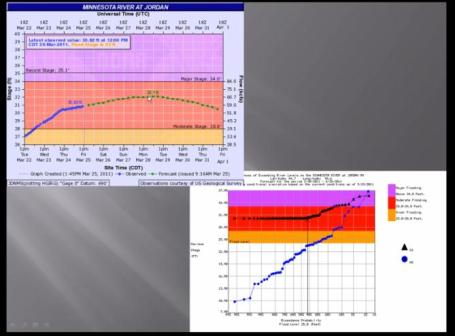
According to NOAA we may see multiple flood crests in the coming weeks, a significant risk of (serious) river flooding lasting into early May.
*
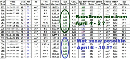
4-8" of liquid water estimated to be in the snow pack over central and western Minnesota. Severity of flooding in April and early May will depend on the rate of warming, and whether we see storms with significant rain (1-2" or more).
*
NWS: Mississippi River is a "wild card". There is still very significant snow on the ground north of St. Cloud - melting snow will eventually feed into the headwaters of the Mississippi. The timing of any subsequent flooding depends on the rate (and duration) of warming, and whether any inevitable warm fronts are accompanied by heavy rain.
*
Homeowners insurance does not cover river flooding. Do you live in a potential flood zone? Scroll down to find out.
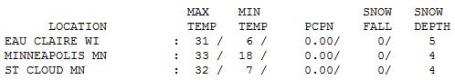
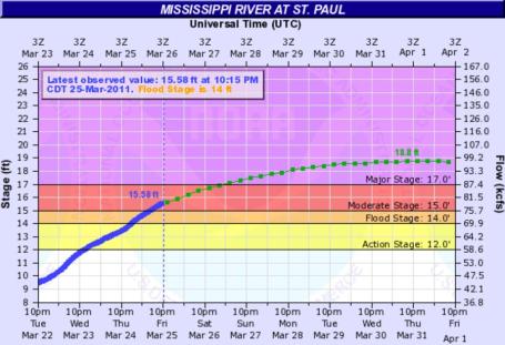 Major Flooding Underway in St. Paul
. The Mississippi River is approaching major flood stage (17 feet). A crest of just under 19 feet is expected by the middle of next week. What does a crest of 18.8 feet mean?
| 18' | Warner Road may become impassable due to high water. |
| 17.5' | Harriet Island begins to become submerged. |
| 17' | Secondary flood walls are deployed at St Paul Airport. |
| 14' | Portions of the Lilydale park area begin to experience flooding. |
source: National Weather Service. More information
here.
 Flood Briefing
. The local Chanhassen NWS
Office has a multimedia briefing on the (continued) flood risk around the state. Click
here to see the details.

 Are You At Risk?
 I was surprised to find out that a previous home was at high risk of flooding. Funny, the real estate agent never mentioned that.
Floodsmart.gov has a good site that allows you to plug in your home's address and find out the risk - see approximate premiums for coverage, even a contact name for a (friendly?) agent who would love to take your call. Remember, most homeowner's insurance policies do not cover damage from river flooding - you need an additional policy.
 Definite Warming Trend
. The models all seem to agree, a higher sun angle with finally tug at the mercury in your back yard, a string of 40s next week, 50 possible by Thursday, even an outside chance of mid 50s to near 60 by next Friday. Right now I don't see any significant rain through the end of March, but a stormier, wetter pattern may return by the first week of April.
 Extended Gibberish?
 I
hope so. The GFS model pulls us back into a stormier pattern as the storm track shifts north again. Warning: this is WAY out on the horizon - the forecast will undoubtedly change a few times between now and early April, but the trend seems to be reasonable and believable. We will have gone 10-12 days with no significant precipitation - we're probably due for a stormier pattern after April 3 or 4. Again, the NWS is more concerned about significant rain (or snow) in April, complicating and possibly worsening the flood situation.
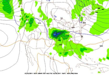
 Well-Timed High Pressure Bubble
. A sprawling region of high pressure centered over Hudson Bay, Canada is ridging southward, keeping any storms, clouds (and wet snow) south and west of Minnesota through the weekend. The downside: temperatures about 10-12 degrees cooler than average. This chilly spell is a God-send of sorts, at least for people living along Minnesota's rivers - slowing the rate of snow melt, taking some of the edge off the worst of the flooding. Click
here for the latest surface map.
 Staying South
. The potential for wet snow has dropped for next Tuesday - recent computer runs keep the storm track far enough south to avoid Minnesota altogether - although Iowa may pick up a couple inches of sloppy, wet snow.
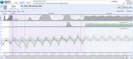
WeatherSpark. This is one of the more clever weather sites I've stumbled upon in recent weeks. The folks at WeatherSpark have over 4,000 weather stations in the database. Not only can you look forward in time (and compare various models), but the historical information at your fingertips is amazing. Check it out
here. All the models show a very gradual warming trend into next week (a string of 40s), with a shot at 50 degrees by next Friday.
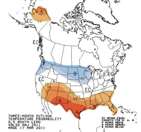
A Reluctant Spring. Remember, I'm just the messenger. Please send all threatening letters, e-mails and tweets to the CPC, the Climate Prediction Center, in Washington D.C. (a division of NOAA). Those sadists are predicting a trend toward chiller-than-normal temperatures through...um...June. We'll see. La Nina (cooling of Pacific Ocean waters) is weakening, which should mean a gradual return to more normal weather patterns - whatever that is. Let's hope they're wrong, but from a flood standpoint this (very) gradual warm-up is a best case scenario. The worst thing right now would be 1). dramatic warm-up into the 60s or 70s, coupled with 2). heavy rain. Fingers crossed we don't pick up an inch or two of rain over the next month or so. Click
here to see the CPC outlook for yourself.
Winter Recap. If you just can't get enough snow (or want to reflect back on how the 5th snowiest winter on record for the Twin Cities came to be) click
this link from the local NWS office. All the storms are listed, in glorious detail. Why do I think we'll had one or two more dates to that (growing) list?
 Record Sierra Nevada Snow and Agricultural Impacts
. Accu Weather
takes a look at the record snows in the west and what impact all this water will have on agriculture later in 2011: "
Record snow has been piling up in the Sierra Nevada this winter, bringing big business to ski resorts, and this will have great benefits for agriculture this summer. To say that feet of snow have fallen in the Sierra Nevada this year would be an understatement as some areas have received a whopping 20 yards or more. Squaw Valley has received 670 inches of snow with 589 inches of snow falling on Mammoth Mountain this winter. Both locations have now had their snowiest seasons on record. Normal snowfall for Mammoth is 343 inches. Prior to the storm Thursday, Alpine Meadows had received a phenomenal 744 inches (62 feet or 20.7 yards). The Sierra Nevada typically get a lot of snow, but what is most important this year is the amount of water locked up in that snow. The amount, over 40 inches in much of the region, is averaging 150% of normal."
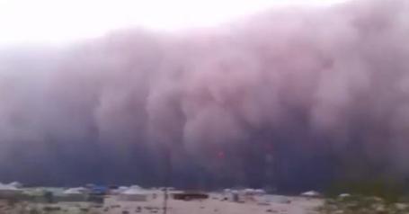
Sandy Apocalypse. Yes, it's chilly out there - everyone is pretty much counting the days until spring (truly) arrives. But at least we don't have to worry about raging sandstorms capable of zero visibility and winds over 50 mph, capable of taking paint off cars. Check out this amazing (recent)
example of a "Haboob" in Kuwait, courtesy of YouTube.
iPhone Falls 1,000 Feet From An Airplane, Found (Undamaged) In A Forest. Amazing but true, the
details from yourversion.com: "If proof were needed that the iPhone 4 is a pretty tough device, then look no further than the one owned by Ron Walker. He’s a U.S. Air Force Combat Controller and Jump Master, meaning he’s up in planes preparing soldiers for parachute jumps most days. On one of his flights recently he was preparing for the jumps when the pocket his iPhone 4 was in became open. As he was leaning out of an aircraft travelling at 150mph at the time the smartphone fell, and continued to fall the 1,000ft to the ground. A cracked screen, dead phone, and no chance of ever locating it again, right? Wrong. When Walker got back on the ground a fellow Air Forcer and iPhone owner had
Find My iPhone installed on his handset. That allowed the lost iPhone to be tracked to a nearby forest where everyone expected it to be smashed."
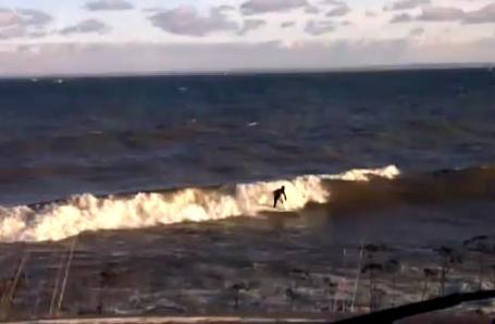
Surf Superior. Now this is a brave, young man. Possibly insane, and I mean that with all admiration and humility. Water temperature: 33 F. There's a rumor that this is a student at Iowa State, but I can't confirm that. He's probably still shivering (in spite of the wet suit). Check out the YouTube footage
here.
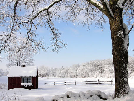
 Backwards Spring
. Even with bright sunshine the mercury never climed out of the low 30s, more typical of early March.
Both St. Cloud and the Twin Cities are still reporting 4" snow on the ground. The average high for March 25 is 45 F.
 Paul's SC Times Outlook for St. Cloud and all of central Minnesota
:
TODAY: Plenty of cool sun. Winds: E 10-15. High: 31 (still more than 10-13 degrees cooler than average).
SATURDAY NIGHT: Partly cloudy, wet roads become icy (again). Low: 13
SUNDAY: Partly sunny, not as chilly. High: 36
MONDAY: Clouds increase, still dry. Low: 21. High: 37
TUESDAY: Clouds, few flurries possible (storm passes well south of Minnesota). Low: 24. High: 39
WEDNESDAY: Intervals of sun, "average" again. Low: 25. High: 43
THURSDAY: Patchy clouds, hints of spring in the air. Low: 30. High: 46
FRIDAY: Some sun, light jackets return. Low: 31. High: 51
A Reluctant Spring
I'm as anxious for spring as everyone else. That's why I cringed after calling up the 90 day temperature trend from CPC, the Climate Prediction Center. It calls for a bias toward cooler than normal temperatures into June. Insert (loud) primal scream here. I'm just the messenger; the real culprit is La Nina, the strong cooling phase of Pacific Ocean water, thought responsible for the 5th snowiest winter on record. One upside to a chilly spring: a slow-motion thaw may reduce the risk of catastrophic flooding.
Local National Weather Service Director, Dan Luna, is just as concerned about record flooding as he was a few weeks ago. "We are far from over with the threat of significant flooding. In fact that threat will be with us through May due to the fact that there is tremendous water in the river system and soils, and it will take weeks to flush that out." Luna adds that there may be multiple crests on area rivers. The Mississippi is a "wild card"; heavy snow remains on the ground with 4-8" of liquid water trapped in that snow pack. If we don't see a sudden spell of 60s and 1-2" of rain in April we may avoid the worst.
No major storms in sight, just a streak of 40s next week, even a shot at 50s by Friday. Yes, spring is coming, but only reluctantly this year.
Earth Now A Windier World. Discovery News has an
article focused on an apparent increase in average wind speeds around the world. A few highlights:
- Top oceanic wind speeds and wave heights have steadily increased over the last 23 years.
- If the trend continues, major storms may become more destructive in the coming decades.
- Climate change may or may not be to blame for the trend, but faster winds could have climate consequences.
"
The world is getting breezier, according to a new study, which found a slow but steady increase in top wind speeds across the oceans over the last 23 years. Although global warming is a suspect, researchers can’t say for sure whether climate change is behind the growing gusts. The trend could simply be part of a natural and long-term cycle that pushes wind speeds both up and down over the course of many decades. But if winds continue to pick up at the same rate, hurricanes could become far more damaging by the middle of the century. Among other implications, engineers would need to rethink they way they plan coastal and offshore structures."
Why Don't You Believe In Global Warming? Making Greener Minds. Hank Campbell from science20.com has an interesting
story about how climate change is being framed in the media, and the demonization that's taking place (on both sides of the argument): "
The past few years have seen a decline in the percentage of Americans who believe what scientists say about climate science. The science community shares some of the blame, obviously; the IPCC made rookie errors in its recent assessment and even intentionally included non-science results as data, and the so-called "Climategate" emails showed scientists weren't always out to promote science as much as they were out to stick it to opponents, behavior just like every other field where humans work. But human fallibility is what it is and we didn't stop driving cars because executives at car manufacturers once buried knowledge of defects. The physics truth is that more greenhouse gases means more warming yet still much of the public, both in America and increasingly worldwide, remains unconvinced. Writing from the Climate, Mind and Behavior conference at the Garrison Institute in New York, which sounds as goofy as 'a conference for environmentalists, psychologists and sociologists to sell global warming better' but is a lot shorter to write, TIME's Bryan Walsh says it all comes down to making more fun of Republicans and 'framing' the debate - the two things which got environmentalists and climate scientists into credibility trouble."
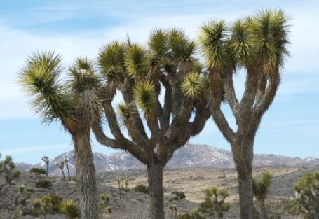
Uncertain Future For Joshua Trees Projected With Climate Change. A recent press release from the USGS: "
FLAGSTAFF, Ariz. — Temperature increases resulting from climate change in the Southwest will likely eliminate Joshua trees from 90 percent of their current range in 60 to 90 years, according to a new study led by U.S. Geological Survey ecologist Ken Cole. The research team used models of future climate, an analysis of the climatic tolerances of the species in its current range, and the fossil record to project the future distribution of Joshua trees. The study concludes that the species could be restricted to the northernmost portion of its current range as early as the end of this century. Additionally, the ability of Joshua trees to migrate via seed dispersal to more suitable climates may be severely limited. “This is one of the most interesting research projects of my career,” said Ken Cole, a USGS ecologist and the study’s lead author. “It incorporated not only state-of-the-art climate models and modern ecology, but also documentary information found in fossils that are more than 20,000 years old.” By using fossil sloth dung found in desert caves and packrat middens — basically, the garbage piles of aptly named packrats — scientists were able to reconstruct how Joshua trees responded to a sudden climate warming around 12,000 years ago that was similar to warming projections for this century. Prior to its extinction around 13,000 years ago, the Shasta ground sloth favored Joshua trees as food, and its fossilized dung contained abundant remains of Joshua trees, including whole seeds and fruits. These fossil deposits, along with fossil leaves collected and stored by packrats, allowed scientists to determine the tree’s formerly broad range before the warming event."

No comments:
Post a Comment