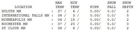
36 F. high temperature in St. Cloud yesterday.
44 F. average high for March 28
53 F. high temperature on March 28, 2010.
2" snow on the ground at STC as of Monday evening.
63.5" snow so far this winter (5th snowiest winter on record).
18z computer runs hinting at a "few inches" of slush by Thursday night.
50+ F. temperatures possible by Friday and Saturday over much of southern MN.
.25 - .60" rain possible Sunday, possibly ending as a period of wet snow over parts of central MN Sunday night into Monday of next week.
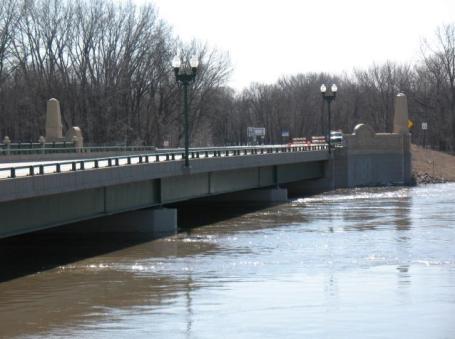
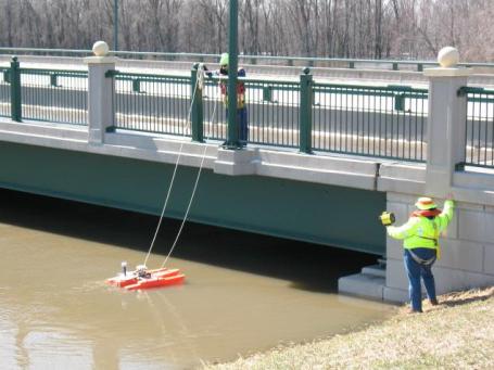
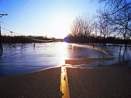
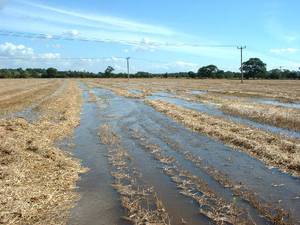
Flooding in Chaska, Minnesota: a series of photos below:
Raise The Bridges? Broadcast Weather meteorologist Bryan Karrick was in Chaska on Monday. He captured the photos of the flooding (above), adding: "
I happened to be on the bridge as MnDOT workers were gathering information on the flow of the river. They are trying to determine the feasibility of raising Highways 41 and 1010, so we can avoid future flooding of both highways."
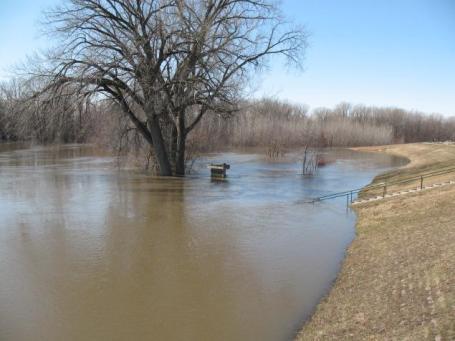
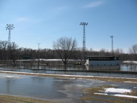
Play Ball? Not So Much. The Chaska Cubs won't be playing on their home field anytime soon. The rising waters of the Minnesota river have engulfed the field - not all that unusual in recent years. Photo courtesy of Bryan Karrick.
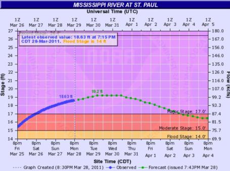
Approaching A Crest. The Mississippi River in St. Paul may rise another 5 or 6" before cresting sometime Wednesday, a slow drop in water levels expected later this week. Source:
NOAA.
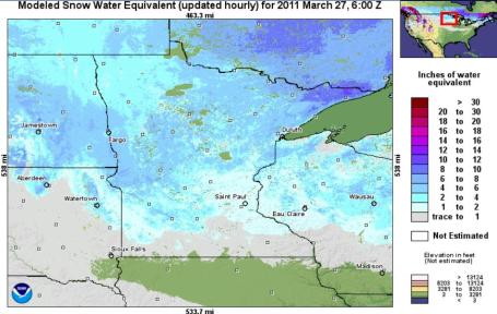
SWE - Snow Water Equivalent. According to NOAA's NOHRSS
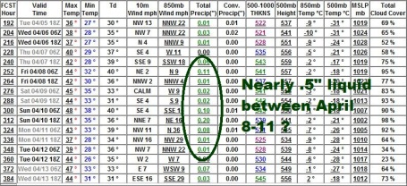
Interactive Snow System there is an estimated 1-2" liquid water remaining in the snow in the metro area (mainly northern/western suburbs). But that number rises to as much as 4-8" across west central, central and northern Minnesota, water which will eventually drain into the headwaters of the Mississippi and Red Rivers.
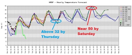
Moving In The Right Direction. The average high is 47 F - we should be close to normal temperatures by midweek, a shot at 50 by Saturday. More importantly nighttime lows remain (consistently) above 32 by Thursday.
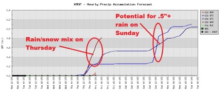
Late Week Puddles. The models print out heavier precipitation Thursday (rain and snow mixed) - a potential for more significant rain Sunday (over .5"?), ending as a little wet snow on Monday.
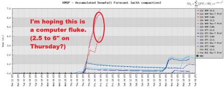
Computer Hiccup? This is a significant change, and I'm not yet convinced it's real - the 18z Monday runs of the models are increasing the snowfall amounts for Thursday. The 00z and 12z runs tend to be more reliable/accurate than the 06 and 18z runs - so I'm not too concerned just yet - but know there is at least a slight chance of a "few inches" of slush, especially Thursday night. A cold rain Sunday may end as a coating - 1" of slush next Monday.
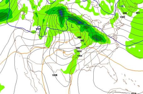 Sunday Puddles
. This is the GFS forecast map (surface pressure and precipitation rates) valid noon on Sunday, showing an area of low pressure over west central Minnesota, heaviest rain (and snow) over northern Minnesota. If this forecast verifies we may see .25 to .60" rain Sunday (even a slight chance of convection, a few scattered T-storms). If the forecast is valid - the rate of snowmelt will increase (significantly) over the weekend.
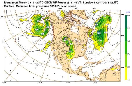 A Very Moist Fetch
. The ECMWF forecast, valid Sunday morning, shows a long (moist) fetch of moisture at 850 mph, roughly 3,500 feet above the ground. The solution is fairly similar to the GFS run, which brings a strong area of low pressure into Minnesota, the best chance of rain from Saturday night into Monday morning, when a cold northwest wind on the backside of the storm may spark a changeover from rain to wet snow. Lovely.
Looking Ahead. The long-range, 15-day GFS model (more of a trend than a forecast) keeps us soggy and slightly cooler than average into mid April, nearly a half inch of rain the second week of the month, highs mostly in the 40s, maybe a few days in the low 50s. Still no sign of any dramatic warming trends: no 60s or 70s anytime soon, good news for Minnesota's stubborn flooding risk (which will probably be with us into early May).
Don't Let Turbulence Freak You Out. Remember when flying was fun? Now, between TSA pat-downs (gropes), full flights, and a diminishing chance of getting that coveted upgrade, it's more work than fun. But those big bumps in the air (atmospheric potholes) aren't cause for concern, according to a recent
article at cnn.com: "
From a little jolt to an all-out roller coaster ride, turbulence is a routine event when it comes to flying, but it scares the heck out of a lot of travelers. Fortunately, if you follow directions, your chances of getting hurt are slim to none. The first thing to remember with turbulence is that it's almost never as bad as you think. In severe turbulence, it might seem like you dropped 100 feet, but it was probably not even 10. Consider driving fast down a dirt road. If you tried to hold on to a cup of water on that ride, you'd be just fine except for the thorough soaking you'd get about two seconds in. On the other hand, if you're in an airplane that hits turbulence, your water usually won't even splash outside of the cup. Unfortunately, we don't have the ability to see that next bump in the sky just yet. For control freaks like me and countless others, that's an anxiety-producing experience. But there are some important things to know about turbulence that should help calm your nerves."
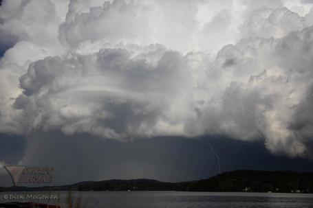
Supercell. Dick McGowan of tornadovideos.net captured this photo of the "supercell" thunderstorm that spawned large hail and tornadoes over Alabama a few days ago.
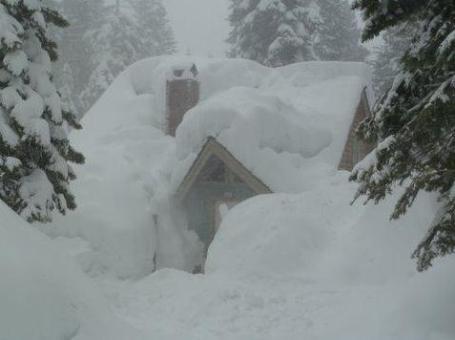
Smothered In Snow. Jim Cantore from the Weather Channel sent out this
photo, taken in Tahoe City - an unimaginable amount of snow in recent weeks!
First Photos Of The Fukushima 50: Please Continue To Live Well, I Can't Be Home For Awhile." A harrowing and heartbreaking story of the 50 brave workers who tried to save the Fukushima reactors, and in the process put their own lives at risk, from "
Good": "
The first photos of the Fukushima 50, the team of men currently attempting to prevent a nuclear meltdown at the Fukushima Daiichi nuclear plant in Japan, have emerged, and they're simultaneously inspiring and heartbreaking. On the one hand, the 50, who have since been joined by 150 others, are all that's right in the world, true symbols of selflessness and sacrifice for the greater good. On the other, they're also sad reminders of the horror Japan's recent tsunami wrought—five of the men are already presumed dead, and others have said they're certain the radiation will kill them eventually. The men's brief messages home have been chilling in their beautiful simplicity and frankness: "Please continue to live well," one of the 50 wrote in an e-mail to his wife. "I cannot come home for a while."
Monday Chill. Yesterday was still 10 degrees below average, in spite of bright sunshine -
snowfall down to 2" in the Twin Cities and St. Cloud.
Paul's SC Times Outlook for St. Cloud and all of central Minnesota:
TODAY: Clouds increase, a bit milder. Winds: E 5-10. High: 37
TUESDAY NIGHT: Patchy clouds. Low: 26
WEDNESDAY: Mix of clouds and sunshine, starting to feel like late March again. High 43
THURSDAY: Clouds increase, mix of rain and some wet snow possible late? There is a potential for some snowy accumulation by Thursday night. Low: 31. High: 45
FRIDAY: Mostly cloudy, feels like spring. Low: 32. High: 49
SATURDAY: Sunnier, nicer day of the weekend. Low: 34. High: near 50
SUNDAY: Cold rain develops. Low: 35. High: 43
MONDAY: Turning colder. Rain may change to wet snow before tapering Low: 39. High: 41 (falling)
Limping Into Spring
"No winter lasts forever; no spring skips its turn," mused writer Hal Borland, who has obviously never spent much quality time in Minnesota. The natives are restless, most of us counting the days until our yards magically reappear.
My older son, born and raised in Minnesota, a man who loves to snowboard & snowmobile, whose face lights up when heavy snow is in the forecast, gave me a reality check yesterday. "Enough! I've had enough snow."
If only it were that easy. Our slow-motion meltdown is just the antidote for Minnesota's ongoing flood risk. A worst case scenario would be a sudden onset of 50s and 60s coupled with heavy rain.
I don't see that specter anytime soon, although 40s will give way to low 50s late in the week, nighttime lows staying above 32 F. by Thursday. That will increase the rate of snowmelt; forecasters still nervous about an estimated 4-8" liquid water trapped in the snow over the headwaters of the Mississippi River. Time will tell, but complacency isn't an option just yet.
A light rain-snow mix is possible Thursday, heavier rain on Sunday, maybe ending as a few inches of snow over central Minnesota by Monday. Welcome to the tortured spring of 2011.
Obama's "Secret" Climate Adaptation Plan. I had no idea that President Obama had signed a special executive order requiring all government agencies (and major subcontractors) to come up with a viable climate adaptation plan. And get this, we have President George W. Bush to thank for getting the ball rolling.
Details in Good.is: "
On March 4th, in a move surely designed to side-step Congress, Obama's Council on Environmental Quality issued instructions to all federal agencies on how to adapt to climate change. All agencies, from the Food and Drug Administration to the Department of Defense, will be required to analyze their vulnerabilities to the impacts from climate change and come up with a plan to adapt. Thousands of governmental employees will be trained on climate science, like it or not. The changes aren't limited to just federal agencies. Countless numbers of private businesses that sell, build, provide logistics or maintenance, or anything else to the government will be forced to comply with new Federal climate adaptation guidelines—all because of Presidential Executive Order 13514. How far reaching is this adaptation action? The National Defense Industrial Association (NDIA) is holding a training and workshop conference on Obama's Executive Order in May. NDIA is the primary private industry group that supports the Department of Defense. To be clear, NDIA connects the DoD to bomb makers Raytheon, bullet manufacturers Sierra Bullets, and the designer of the stealth bomber, Northrup-Grumman. Now NDIA is training defense contractors on climate science and analysis based on a little known Executive Order."
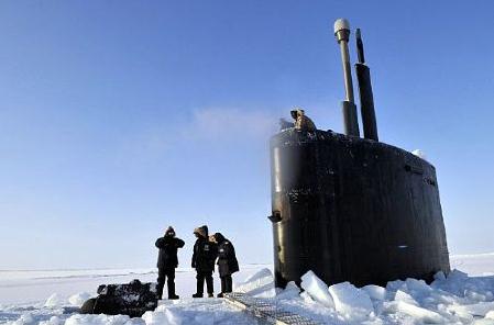
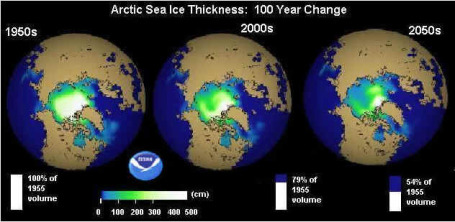
Navy Releases Roadmap For Future Arctic Operations. The Navy released this back in late 2009, but this is the first I've heard of this directive, a direct response by the military to changing conditions in the Arctic region: "
The vice chief of naval operations has released a new roadmap that will guide Navy policy, strategy and investments related to a changing Arctic. The Arctic roadmap was developed by the Navy's Task Force Climate Change, a matrixed organization that includes representatives from various staff and program offices and the operational fleet, with the collaboration of the U.S. Coast Guard and the National Oceanic and Atmospheric Administration. "As the Arctic Ocean continues to show a long-term trend in sea ice decline, the potential for increased human access and activity in the region will some day likely require a greater Navy presence there to protect national interests," said Rear Adm. Dave Titley, oceanographer of the Navy, who is leading the task force. Although the Arctic remains a challenging environment, the potential for resource extraction, like oil, gas, and minerals, and the attraction of significantly shorter shipping routes, will likely attract commercial interests. With more than a thousand miles of coastline and potential sovereign rights to several hundred thousand square miles of ocean area in the Arctic, the U.S. has a strong national security and homeland defense interest in the region. A presidential memorandum signed by in January 2009 tasks the Department of Defense to "project a sovereign maritime presence" in the Arctic. The goal of the roadmap is to ensure naval readiness and capability and promote maritime security in the Arctic region. Key elements of the plan include increasing operational experience, promoting cooperative partnerships and improving environmental understanding. "
The 8,000 Year-Old Climate Puzzle. An intriguing
article from Nature magazine: "
Scientists have come up with new evidence in support of the controversial idea that humanity's influence on climate began not during the industrial revolution, but thousands of years ago. Proposed by palaeoclimatologist William Ruddiman in 2003, the theory says that human influences offset the imminent plunge into another ice age and helped create the relatively stable climate that we are familiar with today. It has been repeatedly panned as implausible by palaeoclimate researchers, but eight years on, Ruddiman and others say that they have the data to support early anthropogenic climate change. The argument centres on a curious trend in atmospheric carbon dioxide and methane levels since the last ice age ended about 11,000 years ago and the current Holocene epoch began. In previous interglacial periods, CO2 levels spiked early and then gradually declined until the globe went into another ice age. The Holocene began by following this trend, but then CO2 levels changed course and began to rise around 8,000 years ago. The same thing happened with methane levels around 5,000 years ago. These trends align with the expansion of human agriculture, and Ruddiman, of the University of Virginia in Charlottesville, argues that it is no coincidence — the clearing of land and expansion of irrigation released huge amounts of greenhouse gases into the atmosphere."


No comments:
Post a Comment