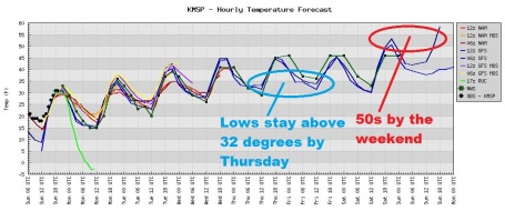
* Gradual warming trend likely this week, a string of 40s, the mercury topping 50 as by late week.
* Next chance of a rain/snow mix: late Thursday into Friday morning, potential for a coating to 1" of slush (which should melt within a few hours of falling).
* Saturday: probably the nicer, drier day of the weekend with some sunshine, highs in the low 50s.
* More rain possible Sunday.
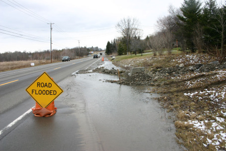
* Mississippi River forecast to crest Wednesday in St. Paul, a little over 2 feet above major flood state.

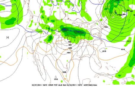
Flooding Underway In St. Paul. This is St. Paul's Upper Landing - click here to see an assortment of webcams in St. Paul, courtesy of the city of St. Paul. Harriet Island is now (partially) underwater, along with Warner Road. An initial crest is likely on the Mississippi River within 48-72 hours.
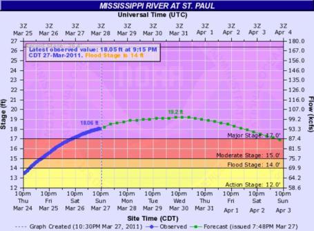
Latest Flood Forecast. Click here to see NOAA's latest prediction for St. Paul - looks like a crest a little over a foot higher than current (rising) levels by Wednesday.
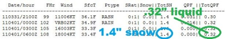
Thursday Night Slush? Models are predicting nearly a third of an inch (liquid) late Thursday into early Friday, temperatures aloft potentially cold enough for a rain/snow mix. As much as an inch of slush is possible - anything that falls will probably melt on contact. If we do pick up an inch of slush we'll have the dubious distinction of living through the 4th snowiest winter in modern-day records.
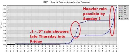
A Cold Sunday Rain? Disclaimer and meteorological caveat: it's early to be talking about Sunday weather. But yes, I'm living for the weekend, like just about everyone else - so why not take a peek into the not-too-distant future? Saturday looks dry with highs topping 50. There may be enough cold (dry) air in place for a rain/snow mix over parts of central Minnesota - probably (mostly) rain in the Twin Cities. With highs in the upper 30s to low 40s I don't expect any significant accumulation right now. Stay tuned...
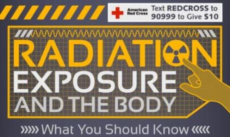
Understanding The Dangers Of Radiation. In light of what's happening in Japan I thought it might be timely to find an article (in this case an "infographic") that explains the effects of radiation on the human body. Here is an excerpt from greenupgrader.com: "Recent fluctuating reports that dangerous levels of radiation have been detected in Japanese food and water have many people concerned. The Fukushima explosion is the worst nuclear disaster in Japan since World War II. This situation comes on the heels of—not one, but two—natural disasters, and the in the midst of this crisis, questions undoubtedly arise about the safety of radiation exposure."

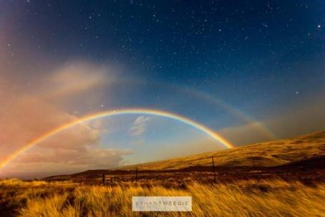
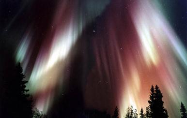
Double "Moonbow". We're all familiar with rainbows - white sunlight refracted (bent) by billions of tiny, prism-like ice crystals into the colors of the rainbow. The same thing is possible with moonlight, although exceptionally rare. This remarkable example (courtesy of spaceweather.com) was captured by Ethan Tweedie in Hawaii on March 24: "I have been trying to get an image of the illusive Moonbow for a long time. This evening on the way back from the Volcano there it was!! It was cold, windy and raining but I toughed it out. After getting some images the CF card failed and all the pictures were gone. Undaunted I dug into my camera bag and pulled another card! I had just enough time to get two pictures off before it disapeared!!! Here is what I got!!!"

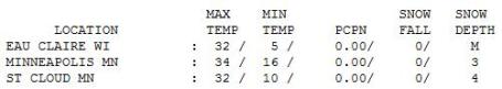
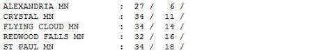
Stunted Spring. 34 on March 27? That's 12 degrees cooler than average. The mercury only recovered to 27 at Alexandria, after waking up to a nippy 6 (above). 3" of snow on the ground - that should be down to zero by Thursday or Friday.
Paul's SC Times Outlook for St. Cloud and all of central Minnesota:
MONDAY: Plenty of sun, still cool. Winds: E 5-10. High: 33
MONDAY NIGHT: Partly cloudy, not quite as chilly. Low: 23
TUESDAY: Clouds increase, turning milder. High: 42
WEDNESDAY: Intervals of sun, snow going fast. Low: 29. High: 46
THURSDAY: Clouds increase, nighttime rain, possibly mixed with snow (slushy coating to an inch?) Low: 30. High: 49
FRIDAY: Definite hints of spring, few showers possible. Low: 34. High: near 50
SATURDAY: Sunnier, nicer (drier) day. Low: 30. High: 52
SUNDAY: Chance of rain, have a "Plan B" - indoors. Low: 36. High: 47
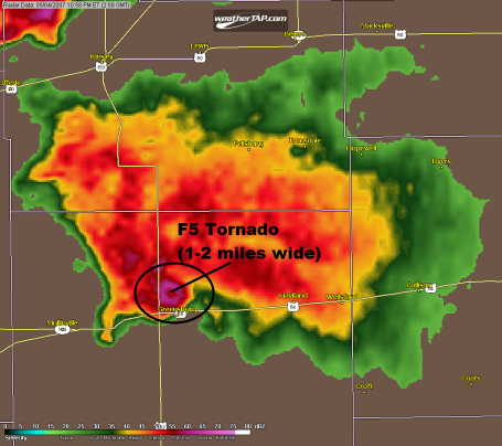
Greensburg, Kansas F-5. This is a Doppler radar image taken May 4, 2007, showing the 1-2 mile wide tornado that leveled the town of Greensburg. Usually the tornado circulation is too small to actually show up on radar - not this time. Look carefully: the donut-shaped swirl in the lower left of the cell is the actual tornado.
High Tech Marvels
The forecast will never be perfect - but new weather technology, coupled with streamlined warning services, have lowered your risk of winding up as a weather statistic.
In the 1920s an average of 240 people out of every million died from extreme weather events every year: drought, flood, wind, extreme heat or cold. According to the International Disaster Database, that number dropped to just 3 per million last decade. Doppler radar, which allows us to zero in on the spinning thunderstorms most likely to spawn tornadoes - has lowered the tornado lead-time (from when it's spotted to when it arrives) from 6 minutes in the 70's to 12-14 minutes today. Weather satellites track hurricanes from space, leaving plenty of time to evacuate inland. In spite of an apparent uptick in extreme weather (especially floods), safeguards are in place that weren't there for your parents.
A southward shift in the jet stream keeps us dry through Thursday; models hinting at a slushy mix Thursday night (coating to an inch of slush?) and rain Sunday, ending as wet snow next Monday?
40s will feel good, 50s by the end of this week; definite hints of spring by Saturday. A stubborn blocking pattern cools us off next week into mid April.
Dear La Nina: please go away.
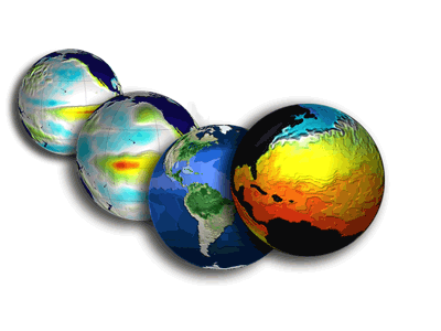
Science And Faith Intersect Over Climate Change. The Providence Journal writes about the moral issues surrounding climate change - the impact on health, food and water supplies has been hardest on those with the least, especially across Africa and Asia: "The changes that farmers, fishermen and gardeners are observing can’t be explained by natural warming trends, the report said. “The billions of tons of carbon dioxide, methane and other greenhouse gases we are pumping into the atmosphere explain these trends very well. What’s more, since these gases stay in the atmosphere and trap heat for decades, we are locked into serious disruptions in our way of life.” The impact of climate change is already evident in the Arctic, and the worst impacts are likely to be in Africa, Roberts said. In 2007, he joined Bradley Parks in writing a book titled “A Climate of Injustice: Global Inequality, North-South Politics and Climate Policy.” They studied 4,000 “climate-related disasters” such as hurricanes, floods, droughts and heat waves. They found that in some countries, especially in sub-Saharan Africa, people were 200 times as likely as Americans to die from climate-related disasters, and 300 times more likely to be left homeless."
No comments:
Post a Comment