56.8" so far this winter
.2" snow Saturday.
5.6" so far in March.
9" snow on the ground.
36 F. avereage high for March 12.
40s likely by Tuesday.
50+ possible Wednesday and Thursday.
7:16 pm Central Daylight Time: sunset time this evening. Did you remember to "spring forward" one hour?
19 mostly minor earthquakes in Minnesota since 1860 (details below).
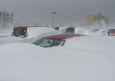
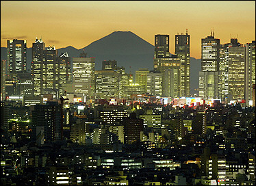
Going Fast. December's drifts are a cold, dark memory. The Big Melt will get underway this week, the 7" of snow on the ground at MSP International probably dwindling down to an inch or two of dirty snow by the end of the week. If you like snow you will absolutely want to get out there today. I plan on taking one last ride on my Polaris sled today before calling it quits for the near term. Odds are we'll still see a few more snowfalls before spring (sticks), but this upcoming week will feel more like the first week of April.
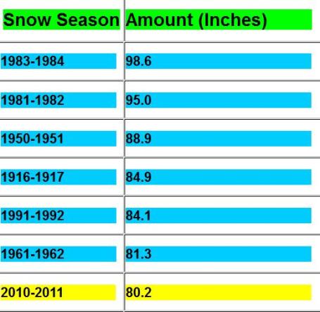 7th Snowiest Winter On Record
. We're over 80" now (80.2" to be exact, with Friday night's snowfall). That brings us up to #7 for the winter, to date. My hunch:
We'll certainly wind up in the Top 5 Winters - I honestly can't see how we don't pick up at least 3 or 4" between now and mid April. Then again, who really knows? More info from the NWS
here.
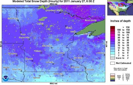
Snow Depth. There is still 8-12" on the ground across much of the metro area (less at MSP International). Over 20" is still on the ground over much of western and central Minnesota, according to NOAA's Hydrological Remote Sensing Center.
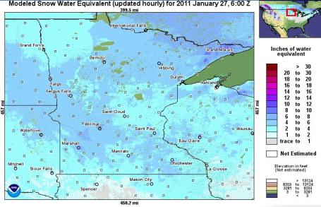
Snow Water Equivalent. There's roughly 4-6" liquid water trapped in the snowpack in the immediate MSP metro area, but pockets of 6-8" liquid water amounts in the drifts over southwestern MN, closer to Windom and Willmar. Click
here to see the raw data for yourself, courtesy of NOAA.
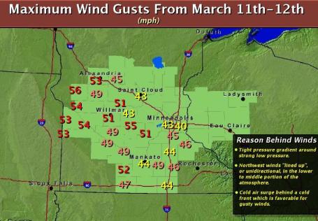
Wild Winds. Check out the peak wind gusts Friday night and Saturday morning, as high as 45 mph. in the Twin Cities metro area, 43 mph at St. Cloud, and 56 mph in Morris. The local NWS has a good explanation of the meteorological factors that whipped up these powerful winds here - another sign of the (imminent) transition from winter to a more springlike pattern later this week.
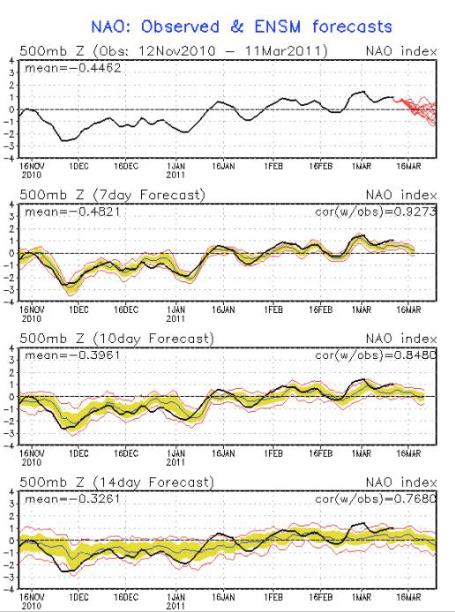
Weakening NAO, North Atlantic Oscillation. The blocking pattern (holding pattern) in the upper atmosphere known as the North American Oscillation, coupled with a strong La Nina cooling of Pacific water - helped to create the conditions responsible for the snowiest winter in 2 decades. That pattern now shows signs of breaking down; the coldest air retreating north of the border. I think we've seen our last subzero reading of the winter season. More cold fronts? Absolutely, but we're turning a big corner in the temperature department: next week will feel more like late March and the first week of April.
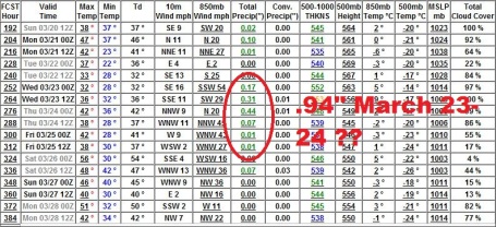
Long-Range Trends. Although it's impossible to get specific about weather events 1-2 weeks away, it does appear that Minnesota will enter a potentially stormier, wetter pattern by the last week of the month. Timing is tricky, the GFS printing out a significant storm around March 23-24 (probably warm enough for mostly rain, but it's just too early to tell). Temperatures through March 28 are consistently in the 40s for daytime highs, with a few 50s. No wintry relapses in sight looking out 10-15 days.
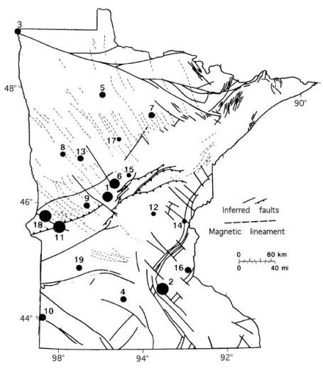
Historical Seismicity of Minnesota. Minnesota is criss-crossed by a series of ancient (dormant) faults. On rare occasions stresses reactivate these old fault lines. According to an exhaustive study of earthquakes in Minnesota (available from the University of Minnesota's
Geological Survey) there have been 19 minor to moderate quakes in Minnesota since 1860. A tremor in Long Prairie in 1860 registered 5.0 on the Richter Scale. Cottage Grove experienced a 3.6 tremor in 1981. A 4.6 shake in Morris in 1975 was strong enough to break dishes and crack chimneys.
But overall, seismic activity is one of the few things Minnesotans do NOT have to worry about.
Asterisks denote earthquakes that were recorded instrumentally. All others and associated magnitudes based solely on intensity data from felt reports.
Felt area Maximum Epicenter Mo/day/yr Lat. Long. (km2) intensity Magnitude (nearest town):
1 Long Prairie 1860-61 46.1 94.9 --- VI-VII 5.0
2 New Prague 12/16/1860 44.6 93.5 --- VI 4.7
3 St. Vincent 12/28/1880 49.0 97.2 --- II-IV 3.6
4 New Ulm 2/5-2/12/1881 44.3 94.5 v.local VI 3.0-4.0?
5 Red Lake 2/6/1917 47.9 95.0 --- V 3.8
6 Staples 9/3/1917 46.34 94.63 48000 VI-VII 4.3
7 Bowstring 12/23/1928 47.5 93.8 --- IV 3.8
8 Detroit Lakes 1/28/1939 46.9 96.0 8000 IV 3.9-3
9 Alexandria 2/15/1950 46.1 95.2 3000 V 3.6
10 Pipestone* 9/28/1964 44.0 96.4 --- --- 3.4
11 Morris* 7/9/1975 45.50 96.10 82000 VI 4.8-4.6
12 Milaca* 3/5/1979 45.85 93.75 --- --- 1.0
13 Evergreen* 4/16/1979 46.78 95.55 --- --- 3.1
14 Rush City* 5/14/1979 45.72 92.9 --- --- 0.1
15 Nisswa* 7/26/1979 46.50 94.33 v.local III 1.0
16 Cottage Grove 4/24/1981 44.84 92.93 v.local III-IV 3.6
17 Walker 9/27/1982 47.10 97.6 v.local II 2.0
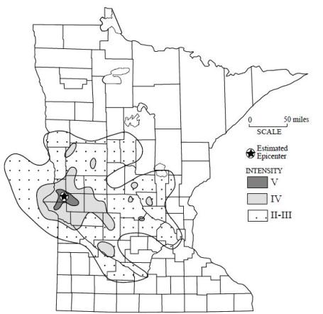
18 Dumont* 6/4/1993 45.67 96.29 69500 V-VI 4.1
19 Granite Falls* 2/9/1994 44.86 95.56 11600 V 3.1
Isoseismal Map of the Dumont, Minnesota, Earthquake of June 4, 1993. The different intensity levels include the following effects:
Intensity II-III - Sensation of light vibrations or movement, felt most commonly by people at rest indoors.
Intensity IV - Dishes rattling, creaking in upper floors of house, sensation like a heavy object striking building or a heavy truck rolling by.
Intensity V - Pictures swinging on walls, small or unstable objects being upset, very minor cracking in weak masonry, such as plaster. Some places in this [intensity V] area may have had
Intensity VI, which includes cracking of plaster and things being shaken off walls and shelves.
Quake Moved Japan Coast 8 Feet, Shifted Earth's Axis. Two tectonic plates grinding past each other in the span of less than 2 minutes actually caused the Earth to shift by as much as 8 feet - an underwater shock that triggered a 30 foot tsunami that reached as far as South America. CNN has the
details: "
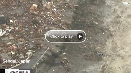
The powerful earthquake that unleashed a devastating tsunami Friday appears to have moved the main island of Japan by 8 feet (2.4 meters) and shifted the Earth on its axis. "At this point, we know that one GPS station moved (8 feet), and we have seen a map from GSI (Geospatial Information Authority) in Japan showing the pattern of shift over a large area is consistent with about that much shift of the land mass," said Kenneth Hudnut, a geophysicist with the U.S. Geological Survey (USGS). Reports from the National Institute of Geophysics and Volcanology in Italy estimated the 8.9-magnitude quake shifted the planet on its axis by nearly 4 inches (10 centimeters). The temblor, which struck Friday afternoon near the east coast of Japan, killed hundreds of people, caused the formation of 30-foot walls of water that swept across rice fields, engulfed entire towns, dragged houses onto highways, and tossed cars and boats like toys. Some waves reached six miles (10 kilometers) inland in Miyagi Prefecture on Japan's east coast."
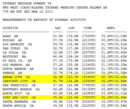
Peak Wave Heights From Pacific Tsunami. The 8.9 quake that has devastated much of of northern Japan created a tsunami that swept across the entire length of the Pacific, with reports of 8-9 foot waves coming ashore over northern California. Data courtesy of NOAA.
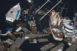
Tsunami Damage In The USA. The New York Times
reports on (minor to moderate) damage reported in parts of Hawaii and the west coast, especially the northern coastline of California: "
The wave that hits the nearby coastline first is usually the most destructive, said Eric Geist, a scientist with the United States Geological Survey. But with the tsunamis that head out to sea, some of the energy dissipates as the wave spreads outward across open ocean, like a ripple from a rock thrown into a pond. Coastal features can then either reduce or amplify some of the energy as the wave reaches land. “Once the first wave hits the coastline, it gets very complicated,” Dr. Geist said. Reports from Sendai, the city in Japan closest to the quake, suggested that wave heights reached more than 12 feet above normal as the first tsunami wave struck. Waves in parts of Hawaii reached seven feet above normal, damaging piers and marinas and causing some flooding. But by midmorning, sunbathers had returned to Waikiki Beach, though in smaller numbers than usual. Here and there, children ventured into the water, despite official warnings to stay out. In North America, the Coast Guard said that one person was swept to sea near McKinleyville, Calif., while trying to take pictures of the approaching waves. A search had begun. Four people were also swept to sea in Curry County, Ore., overtaken as they, too, were watching the waves. Two managed to get back to shore, officials said, while the others — one of whom almost drowned — were rescued."(AP photo above shows damage to the harbor in Crescent City, CA).
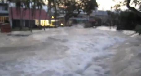
Tsunami Hits Kona, Hawaii. This guy got a little too close to the surging waves that engulfed Hawaii in the wake of Japan's 8.9 earthquake. Darwin Award anyone? Click
here to see the harrowing YouTube footage. No, don't try this at home.
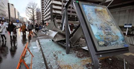
Japan's Strict Building Codes Saved Lives. Although there is considerable second-guessing about the logic of building nuclear reactors close to active fault lines, there is no question that Japan is leading the world in improving building codes to withstand major quakes, spending over a billion dollars in recent years to reinforce buildings, large and small. One thing is fairly certain: had these precautions not been taken, the death toll from Friday's quake would have been several orders of magnitude higher. Here's an
article in the New York Times: "
Hidden inside the skeletons of high-rise towers, extra steel bracing, giant rubber pads and embedded hydraulic shock absorbers make modern Japanese buildings among the sturdiest in the world during a major earthquake. And all along the Japanese coast, tsunami warning signs, towering seawalls and well-marked escape routes offer some protection from walls of water. These precautions, along with earthquake and tsunami drills that are routine for every Japanese citizen, show why Japan is the best-prepared country in the world for the twin disasters of earthquake and tsunami — practices that undoubtedly saved lives, though the final death toll is unknown. In Japan, where earthquakes are far more common than they are in the United States, the building codes have long been much more stringent on specific matters like how much a building may sway during a quake."
Japan's Industrial Heart Escapes Heaviest Blows. Had the epicenter of the quake been closer to Tokyo, Japan's heavily populated and industrialized core, the death toll and subsequent damage could have been far worse. Here's an excerpt from a New York Times
story: "
As bad as the toll might eventually be in lives and property from Japan’s earthquake and tsunami, the fact that the disaster hit far from Japan’s industrial heartland will at least soften the economic blow, both at home and abroad. The epicenter was in and around the coastal city of Sendai, nearly 200 miles northeast of Tokyo, the nation’s population center, and well north of Japan’s primary manufacturing region running from Nagoya to Osaka and farther south and west. “If this had been a couple hundred miles to the south, the economic and human toll would have been almost incomprehensible,” said Marcus Noland, a senior fellow at the Peterson Institute for International Economics. “In that respect, Japan dodged an enormous bullet here.”
In New Case, iPad Starts In An Instant. O.K. Full disclosure: I picked up a new iPad2 at the MOA Apple Store Friday evening. It's thinner, lighter, smarter (yes, perhaps I'm compensating a bit here). With 2 processors the new iPad seems much faster, opening up apps, multitasking is a breeze, and having 2 cameras is a plus, especially if you videoconference from time to time. I find that 80-90% of the computing I used to do on my laptop can now be done (more comfortably) on the tablet - especially consumption of media: newspapers, TV shows, movies and social media. There's a new case option that only works on the iPad2; here's a
story from the New York Times: "
In technology, fast is never fast enough. When Apple begins selling its iPad 2 on Friday evening, many of the new device’s features may be upstaged by a lowly accessory, the “smart cover,” a protective case designed by Apple that snaps onto the iPad through magnets and doubles as a stand. The cover’s “smarts,” though, come in part from being able to turn the iPad 2 on when you open it and off when you close it. The click and finger swipe — three to four seconds, in an unscientific test — that stood between you and the digital world in the original iPad? Gone. The cover turns on the iPad 2 faster than you can wake up your PC or Mac and faster than you can turn on your car or television. It is a bit like the refrigerator door. You open it, and the light goes on, revealing all there is to eat. The smart cover underscores Apple’s knack for design, not to mention the legendary marketing chops of its chief executive, Steven P. Jobs. But more than that, it taps into our apparently insatiable hunger for instant gratification and desire to be one with our favorite gadgets."
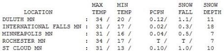
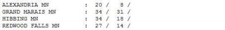 Blustery Saturday.
 Those 30-40 mph winds gradually eased during the day on Saturday. After a cold start the mercury recovered (a little), reaching
and the Twin Cities, but only 27 at Redwood Falls, where there is more snow on the ground.
Paul's SC Times Outlook for St. Cloud and all of central Minnesota:
TODAY: Fading sun, less wind. Winds: W 5-10. High: 29
SUNDAY NIGHT: Patchy cllouds, seasonably cool. Low: 18
MONDAY: Mix of clouds & sun, milder. High: 37
TUESDAY: Rain showers, heavy jackets optional. Low: 31. High: 47
WEDNESDAY: Slightly "feverish". Sun returns. Low: 32. High: near 50
THURSDAY: More clouds, rapid melting. Low: 35. High: 55
FRIDAY: Some sun, time to fire up the grill? Low: 36. High: 51
SATURDAY: Sunny start, rain showers late? Low: 31. High: 46
Spring Ahead
Early this morning we set our clocks ahead one hour, welcoming Daylight Saving Time. This week we'll spring forward, for real. A taste of April is likely, with 2 or 3 days above 50. No major storms will accelerate the rate of snow-melt (just light rain showers Tuesday). Long range guidance is hinting at a stormier pattern the last 10 days of March. That's the big wild card for flooding: will we see heavy rain (or significant snow) into early April? Too early to know.
A recent e-mail: "Paul, the tragedy in Japan is terrible. Are we prone to tremors here?" According to the U. of Minnesota's Geologic Survey, Minnesota has one of the lowest levels of earthquakes in the USA; a total of 19 small to moderate quakes since 1860. Very rare, Minnesota quakes are attributed to "minor reactivation of ancient faults in response to modern stress." A 4.8 magnitude quake in 1975 cracked chimneys in Morris. What light shakes we've seen are clustered mainly over west central Minnesota. More details on my weather blog.
Like snow? Get out and romp in it TODAY. 7" out there now will shrink to only 1-2" of (nasty) snow by the end of this week.
Like turning on a light switch. Instant spring!
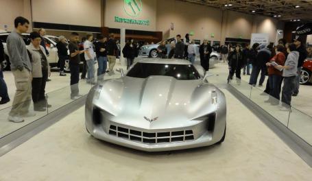
Drool-Worthy. O.K. I had to get out of the house, so my oldest son (Walt) and I went down to the Twin Cities Auto Show at the Minneapolis Convention Center...to um...stretch our legs and check out the eye-candy. From top to bottom: Mercedes SLS, Audi R8 Spyder and the new Corvette Concept. I was also impressed with the number of green/hybrid alternatives this year. I sensed some overall optimism that wasn't there last year - although everyone is still pretty shell-shocked about what's happening in Japan. Hard to get too happy with all the loss and heartache on the other side of the Pacific. By the way, today is the last day of the Auto Show. Still time to check it out.


No comments:
Post a Comment