55.8" snow so far this winter.
9" snow on the ground as of Friday evening.
4.6" snow in St. Cloud so far in March.
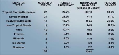
1% According to heating degree data kept by the NWS we've spent roughly 1% more than usual heating our homes and businesses since December 1, 2010.
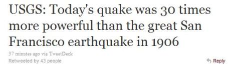
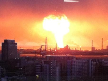
8.9 Magnitude of the massive earthquake that hit Japan early Friday. It's estimated that the tremor was 30 times stronger than the devastating San Francisco quake of 1906, nearly 8,000 times stronger than the quake that hit Christchurch, New Zealand last month.
6 Miles: Distance the tsunami moved inland after coming ashore.
600 mph. Speed of the fastest-moving tsunami waves, propagating away from the epicenter of the earthquake.
1 Resident of Crescent City, California was swept out to sea Friday morning as an 8 foot tsunami swept ashore, damaging dozens of boats in the harbor.
 Wild Winds
. Friday night's
surface map shows a very tight pressure gradient (isobars, lines of constant pressure packed very tightly together around a storm centered over the MN Arrowhead). The result: sustained winds of 20-40 with gusts over 50 mph. I saw a few wind gusts over 70 mph earlier in the day Friday over North Dakota. Map courtesy of Meteostar.
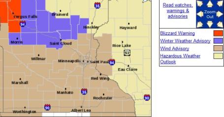
Wind Advisory Metro - Blizzard Warning Red River Valley. A sharp contrast in temperature behind a vigorous March cold front will whip up 30 mph. winds early Saturday, with gusts over 50 mph possible. That may produce some blowing/drifting snow outside the metro area, with blizzard warnings posted north/west of Fergus Falls for visibilities near zero in whiteout conditions.
Minor Clipping. The fast-moving storm that whipped up 40-50 mph. gusts overnight put down a fresh carpet of snow over far northern Minnesota, some 1-3" amounts near the Canada border. I don't see any more accumulating snow through the end of next week.
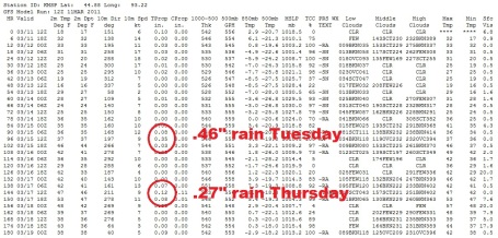
Showery Rains Next Week. The GFS prints out about .46" rain next Tuesday, another .27" on Thursday. Lately the GFS has been more unreliable than usual, overestimating rainfall (and snowfall) amounts. Hopefully that trend will continue for the next few weeks.
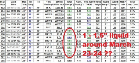
Weather Trend: Stormier Late Month? Not sure if the GFS has a handle on what
may be a significant storm around March 23-24. That's still way out on the horizon - the models have not handled the (rapid) transition from a wintry regime to a more springlike pattern well. In fact the GFS has wildly overestimated precipitation over the last couple of weeks - with any luck the "storm" (rain or wet snow) predicted for late month will not materialize.
Flood Potential. Professor Mark Seeley has an interesting
post in his weekly Weather Talk blog, focused on the factors that are making this a potentially historic spring for river flooding across Minnesota. He writes: "
Decades ago before numerical models were used in hydrology to forecast floods, Joe Strub the chief meteorologist in the Twin Cities used a five factor scaling model to estimate the potential for spring snowmelt floods. The five factors were:
1.Estimates of fall soil moisture recharge up until soil freeze-up going into winter
2.Measurements of frost depth in the soil.
3.Measurements of seasonal snowfall, and snow water content in the snow cover.
4.Forecasts of spring (especially March and April) precipitation.
5.Forecasts of spring thaw period, both intensity and duration.
When all or most of these factors are above historically averaged values, the threat of flooding is high. In the context of the current situation in Minnesota for this winter the only factor that has been below normal is the depth of soil frost, which was less than normal around the state this year. In fact in many places there is little of any soil frost left. But the BIG PLAYERS in the threat of spring flooding this year are (1) saturated soils with little room to hold more water, and (2) abundant seasonal snowfall and snow water content (4-6 inches) that is yet to melt and begin flowing through the state's watersheds. Obviously the biggest uncertainties rest with the final two factors in this conceptual model: Will March and April deliver above or below normal precipitation amounts? Models suggest that precipitation will be above normal for the second half of March. It also looks like March may start to exhibit a warm up as early as next week, but hopefully there will be frequent freeze/thaw cycles to gradually meter out runoff from the snow pack."
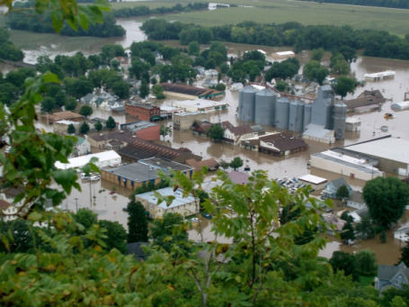
Rivers Flood Across East - Forcing Evacuations. An
update from the AP: "
WOODLAND PARK, N.J. (AP) -- Rivers rose from Maryland to Maine on Friday after days of rain, filling basements with water and forcing hundreds of people from their homes but so far not fulfilling fears of widespread catastrophe. Some of the hardest-hit areas were just outside New York City, which is emerging from a snow-filled winter. Flood-prone parts of northern New Jersey were under water not expected to recede for a few days in spots. By Friday afternoon, 1,500 homes in near the Pompton River in Pequannock had to be evacuated, as did about 100 in Fairfield, Gov. Chris Christie said. A handful of shelters opened by midday, and the American Red Cross was preparing more. In Woodland Park, N.J., Mel Sivri spent the morning preparing for what havoc the Passaic River would wreak."
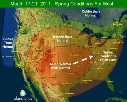
Warming Trend. The folks at
Planalytics (a partner and client of WeatherNation) are predicting a very significant thaw for most of America the third week of March as prevailing jet stream winds blow from the west/southwest. A few details: "
While many folks in the Southern Tier have experienced tastes of Spring over the past few weeks, those in the North have dealt with Old Man Winter and remnants of a powerful late-week storm. As we move through next week many major markets in the Northeast and Midwest will warm up significantly, driving consumer demand."
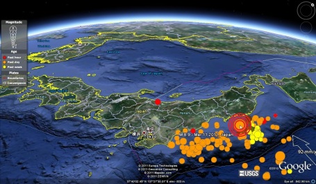
Visualizing The Quake. With Google Earth you can see where the 8.9 quake was in relation to downtown Tokyo. Notice the flurry of smaller tremors in the last 24 hours. Some residents reported minimal warning before the main quake struck - as little as 15 seconds.
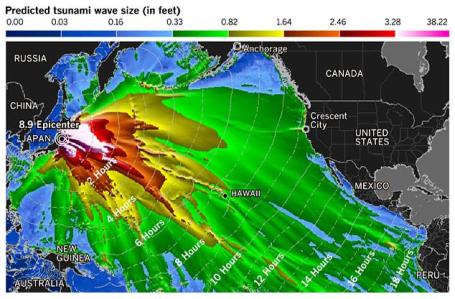
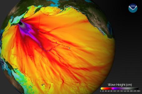
Visualizing The Tsunami. This
amazing image is courtesy of NOAA. More details: "
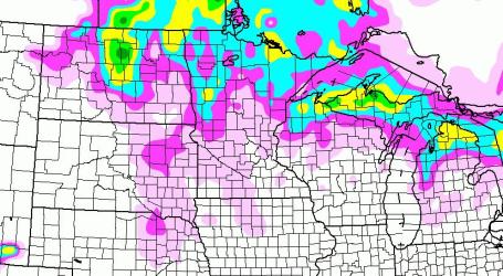
Model runs from the Center for Tsunami Research at the NOAA Pacific Marine Environmental Laboratory show the expected wave heights of the tsunami as it travels across the Pacific basin. The largest wave heights are expected near the earthquake epicenter, off Japan. The wave will decrease in height as it travels across the deep Pacific but grow taller as it nears coastal areas. In general, as the energy of the wave decreases with distance, the near shore heights will also decrease (e.g., coastal Hawaii will not expect heights of that encountered in coastal Japan).The second image shows the depth of the Pacific Ocean floor. Notice the similarity between areas of low wave height and deeper areas of the ocean."
Perspective. Thought to be 8,000 times stronger than the tremor that hit Christchurch, New Zealand in late February, yesterday's mega-quake near Tokyo was 30 times more powerful than the Great San Francisco Quake of 1906.
Tweet courtesy of Breaking News Wire.
 Tsunami Speed Comparable To Clip Of Jumbo Jet
. CTV Edmonton
reports that some of the initial waves propagating away from the quake epicenter moved at speeds of over 600 mph: "
The U.S. Geological Survey says the Friday's quake appears to be the most major to strike Japan since officials began keeping records in the late 1800s. The USGS website maintains a list of historic earthquakes, including those recorded in Japan. According to the USGS website, the worst known quake for fatalities in Japan occurred in September 1923, when 143,000 people died in a 7.9-magnitude quake. More than half the homes in the Tokyo-Yokohama area were destroyed in the disaster. The second-most deadly event occurred in June 1896, when an 8.5-magnitude quake struck off the coast of Sanriku and brought on a tsunami that killed more than 27,000 people. Ninety per cent of the world's earthquakes occur in a range of earthquake and volcanic zones known as the Ring of Fire, which stretches around the Pacific Ocean and includes Japan."
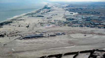
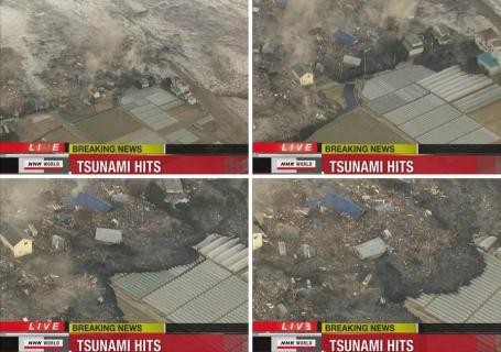
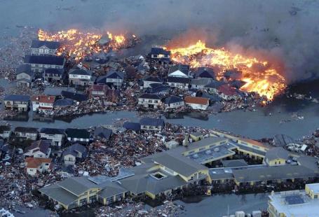
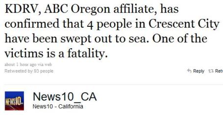
 Significant Destruction And At Least One Fatality In Crescent City, California, As Tsunami Hits West Coast of USA
. Here's an
update from the L.A. Times: "
Eight-foot waves from the Japan tsunami destroyed much of Crescent City harbor, battered boats, closed the 101 Freeway and left one person missing. KDRV-TV reported that four people were washed out to sea Friday. Three were hurt and one is feared dead. The Associated Press reported that the Coast Guard was searching for a man swept out to sea while taking pictures of the tsunami. Local residents reported that about three dozen boats were "crushed" in the harbor and that surging waters significantly damaged or destroyed most of the docks. ocean water surging up Elk Creek north of the harbor reportedly lapped up to front doors of the community center's cultural center. Officials were warning residents to expect higher surges throughout the day, one resident said by telephone. Officials from the Sheriff's Department and the city could not be reached. Crescent City, near the Oregon border, was the scene of a devastating tsunami in 1964 which killed 11 people and destroyed 289 homes and businesses.
"
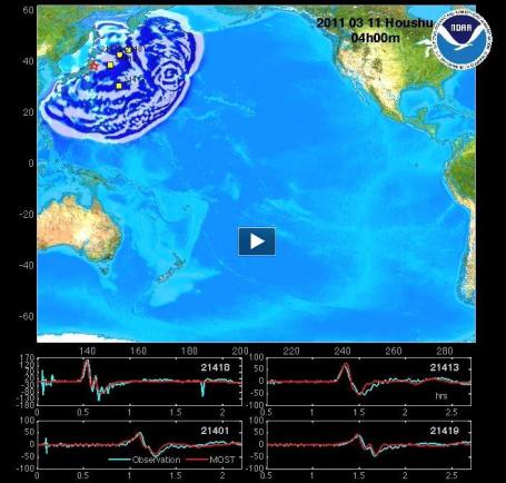
Tsunami Time-Lapse. This
model of tsunami propogation across the Pacific is courtesy of NOAA and Stu Ostro at the Weather Channel.
* More quake/tsunami resources from the Washington Post
here.
Incredible Earthquake/Tsunami Photos. Canada's National Post has some
amazing photos - the scope of the disaster is simply beyond belief.
What It's Like To Live Through An 8.9 Earthquake. I don't think any of us can imagine what it's like to live through a massive quake (keep in mind the Richter scale is logarathmic - a quake of 9.0 is 10 times stronger than an 8.0 tremor). The earthquake that struck 230 miles off the coast of Tokyo was the strongest ever measured in Japan, and the 5th strongest worldwide since 1900. From a
personal blog at Time Out Tokyo:
3.15pm
"
The first shaking started about 30 minutes ago. It still hasn't stopped. I'm writing this from the Time Out office, a ground floor room at the base of a relatively new building. Across the road there's a tenement block. It's swaying horrifically - so much so, in fact, that it looks like a miniature, as though it's been subjected to tilt shift photo technology. I can't quite compute seeing a building doing that. As I write, I can't get through to anyone. Nothing in the immediate vicinity has collapsed, but we're unable to get direct news from our friends and families - all the phones are down. The streets are full of people. What sound like air raid sirens are going off across the city. A colleague is on a train on the way to Narita Airport. He says it has stopped and that it's swaying in its tracks. The Tokyo folk in my office, born and raised in this city, say they've never felt anything like this before. They're jittery, which just makes me even more jittery. We're getting unconfirmed reports from across the city - burning buildings in Odaiba, tsunamis crashing into Iwate. The only thing that seems to be working is Twitter, which is proving itself to be a doom-ladened rumour mill. 7.9 on the Richter scale, say the reports. Don't suppose that's in Tokyo, though. It's going to have been much worse elsewhere. The aftershocks are almost as strong as the initial quake. This is no Christchurch, but we live with the daily fear here in Tokyo that, any day, it could be. For the moment, we can only hope that nobody is badly hurt."
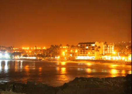
Hawaii Surge. Here is YouTube
time-lapse footage of the tsunami pushing into the bayfront at Kailua Kona during the wee hours of the morning Friday.
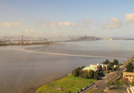
Tidal Surge Enters San Francisco Bay. This remarkable
photo was taken near Berkeley, showing the storm surge from the Japan tsunami entering the bay. From ABC News, Mother Jones and Berkeleyside.com: "
Tsunami makes it to our back yard…San Francisco Bay, moving toward Emeryville on the Bay’s east side. The Bay Bridge and San Fran are visible in the background." (click on link to see full-screen).
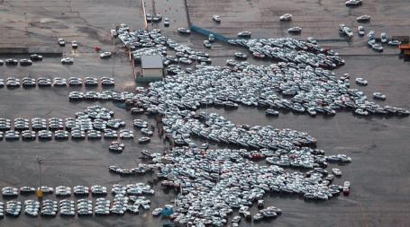
Aftermath. An unbelievable
sight at the Nissan lot. Courtesy of Autoblog.
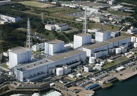
Japan May Have Hours To Prevent A Nucler Meltdown. A truly frightening
update from Reuters: "
Tokyo Electric Power Co (TEPCO) (9501.T) is racing to cool down the reactor core after a highly unusual "station blackout" -- the total loss of power necessary to keep water circulating through the plant to prevent overheating. Daiichi Units 1, 2 and 3 reactors shut down automatically at 2:46 p.m. local time due to the earthquake. But about an hour later, the on-site diesel back-up generators also shut, leaving the reactors without alternating current (AC) power. That caused Tepco to declare an emergency and the government to evacuate thousands of people from near the plant. Such a blackout is "one of the most serious conditions that can affect a nuclear plant," according to experts at the Union of Concerned Scientists, a U.S. based nuclear watchdog group. "If all AC power is lost, the options to cool the core are limited," the group warned."
* I lived through TMI, Three Mile Island. My boyhood home was 23 miles downwind of the crippled nuclear plant in 1979, just outside of Middletown, PA. Our bags were packed, we were prepared to evacuate (both lanes of the PA Turnpike were set to be moving evacuees away from the Harrisburg, PA area. At the time they told us that, if the core does melt down, the area might be uninhabitable for close to a century or longer. Recent estimates suggest that we came within 30 minutes of a hydrogen bubble inside the reactor exploding (like a conventional bomb - not a nuclear explosion). But that would have almost certainly punctured the containment shelter, spewing radioactive steam over thousands of square miles, making a meltdown of the nuclear fuel almost inevitable. It was a very close call - and this disaster is bringing back some very bad memories. At last report a 6 mile perimeter around the nuclear plant has been evacuated as a precautionary measure.
 How Quake Prediction Works (Or Not)
. I saw some televized reports from earthquake survivors who told of a 'few seconds" warning before the ground began to shake. Which brings up a logical question: why can't we predict earthquakes with any level of accuracy? Here's a timely
story from MSNBC: "
Japan has spent well more than $1 billion on earthquake prediction systems, including a network of more than 1,000 GPS-based sensors scattered around the country — and the payoff came today when Tokyo's residents were given up to a minute's warning that a Big One was on the way. That may not sound like much, but it's enough time for people to switch off their gas lines and get beneath a table or a door frame. "The system functioned well, because warnings were seen on television across the country," Hirohito Naito, a seismic expert at the Japan Meterological Agency, told AFP. The agency is in charge of quake preparedness as well as weather forecasting, and researchers have invested decades of effort into Japan's early-warning system. It's considered a model for the rest of the world, and U.S. researchers are adapting it for a system known as the California Integrated Seismic Network. The system capitalizes on the fact that a seismic event sends out two types of shock waves: primary or P-waves, which move up and down; and secondary or S-waves, which shake from side to side. The P-waves travel faster but are weaker, while the S-waves are slower but do more damage. When Japan's system picks up the P-waves, it calculates how far away the source of the shaking is and issues an alarm while the S-waves are still en route. A warning can be broadcast via TV, radio, cell phones and home alarms less than 10 seconds after the P-waves are detected."
Thanks Charlie. Good grief - he's (sadly) everywhere...
Japan Quake Moved St. Louis "A Fraction Of An Inch". Strange, but (apparently) true. A
story from stltoday.com: "
Friday's massive earthquake near the coast of Honshu, Japan, one of the strongest ever worldwide, actually moved St. Louis up and down but nothing that people here would notice, an earthquake expert at St. Louis University says. "It has no direct affect on our earthquake problem," says Robert B. Herrmann, with St. Louis University's Department of Earth and Atmospheric Sciences. "It's just too far away." Herrmann added: "St. Louis moved up and down but it just moved up a fraction of an inch because of this earthquake. But it moved up and down so slowly no one would have felt it. It's too far away to affect us, and it's too far away to do anything in the earth related to earthquakes in the St. Louis region." "It's just a reminder that earthquakes happen without warning, and it's important to be prepared and trained to respond," Herrmann said."
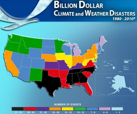
Relative Risk. Friday's massive quake and tsunami got me thinking about overall risk (from natural disasters). Yes, we have long, soul-grinding winters here in Minnesota, but the ground underfoot is firm and stable, not prone to quakes or tremors. No active fault lines anywhere in the Upper Midwest (although the New Madrid fault does pose a significant risk to St. Louis and Memphis, where building codes haven't kept up). Since 1980 NCDC (division of NOAA) reports 10-12 billion dollar disasters in Minnesota. That compares with 31-35 billion dollar disasters from Texas to North Carolina, prone to not only floods and tornadoes but hurricanes. The graphic is
here - more on America's billion dollar disasters from NCDC
here.
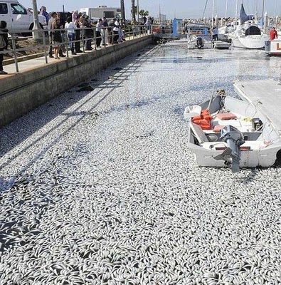
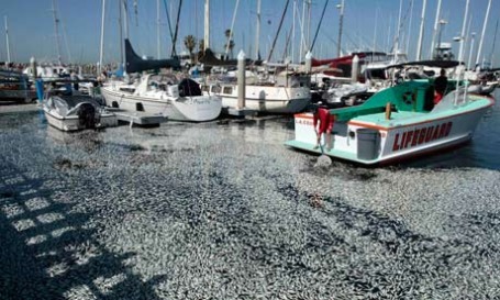
Millions Of Dead Sardines Found In California Marina. Under the heading of "what the heck is going on?" comes this story - millions of dead sardines/anchovies washing up into a Redondo Beach, California marina.
More from the U.K. Guardian: "
Millions of dead sardines have been found floating in a marina just south of Los Angeles, puzzling authorities and triggering a massive clean-up effort. Footage showed masses of dead fish, said by a police spokesman to be about a foot deep on the surface, choking the waters in and around dozens of private boat slips in King Harbour Marina in Redondo Beach. "Essentially Basin 1 of Redondo Beach harbour is full of dead sardines floating on the water, probably 5% of the total basin harbour is filled with sardines that are dead," a California department of fish and game spokesman, Andrew Hughan, told Reuters. He said biologists had tentatively concluded that the fish, initially identified by police as anchovies, died from oxygen deprivation after being driven by a storm into a closed-off pier area."It looks like they just swam in the wrong direction and ended up in a corner of the pier that doesn't have any free-flowing oxygen in it," Hughan said."
New Model Explains Mystery Of Missing Sunspots. Here's a timely
article from gizmag.com: "
Direct observation of sunspots has, more or less, been going on continuously since they were first observed in the seventeenth century. So, you can imagine the puzzled expressions on the faces of astronomers the world over when the phenomena all-but disappeared from view for a couple of years recently. Now, research sponsored by NASA and the government of India has produced the first computer model that explains the prolonged cyclic minima during 2008 - 2009. The simulations suggest that plasma currents deep inside the sun interfered with the formation of sunspots. It was the lowest sunspot activity in almost 100 years, and caused the weakening of the sun's magnetic field which led to cosmic rays being allowed to penetrate our solar system in record numbers. It also caused the Earth's upper atmosphere to cool and collapse, and led to a halt in the decay and subsequent buildup of space debris surrounding our planet. However, one good thing to come from this extended period of sunspot inactivity was the determined efforts of scientists to better understand the solar cycle."
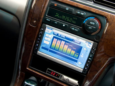
Researchers Show How A Car's Electronics Can Be Taken Over Remotely. Great. I just got over the cold reality that my cell phone is no longer safe from viruses (or marketers). Now comes this
story from the New York Times: "
Because many of today’s cars contain cellular connections and Bluetooth wireless technology, it is possible for a hacker, working from a remote location, to take control of various features — like the car locks and brakes — as well as to track the vehicle’s location, eavesdrop on its cabin and steal vehicle data, the researchers said. They described a range of potential compromises of car security and safety. “This report explores how hard it is to compromise a car’s computers without having any direct physical access to the car,” said Stefan Savage of the University of California, San Diego, who is one of the leaders of the research effort. Given that the researchers were able to do it, they are now trying to pinpoint just how hard it might be for others, he said."
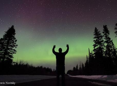
Auroras Invade The USA. A series of solar storms are impacting Earth's magnetic field. Here's an
update from spaceweather.com: "
Earth's magnetic field is still reverberating from a CME strike on March 10th. During the past 24 hours, Northern Lights have descended as far south as Wisconsin, Minnesota, and Michigan in the United States. "At one point the lights filled more than half of the entire sky," says Travis Novitsky, who sends this self-portrait from Grand Portage, MN."
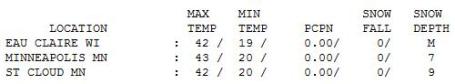
The Big Melt Begins. 43 F. felt pretty good Friday afternoon under a partly sunny sky, our snow cover down to 7", but
9" of dirty snow on the ground in St. Cloud. If you like snow get out this weekend - by next weekend we should be down to an inch or two of slush (with more snow in drifts), but this looks like a very rapid meltdown over the next 2 weeks - the impact on the river potential remains to be seen.
 Paul's SC Times Outlook for St. Cloud and all of central Minnesota:
TODAY: Wind Advisory. Winds gust over 40 mph this morning with drifting outside of town. Flurries taper, very windy with wind chills dipping into single digits. NW 20-40. High: 30 (20s most of the day)
SATURDAY NIGHT: Partly cloudy (chance of seeing the "Northern Lights"). Don't forget to "spring forward" one hour before bed. Low: 8
SUNDAY: Some sun, less wind (change clocks). High: 32
MONDAY: Clouds increase, milder. High: 41
TUESDAY: Rain showers taper, April-like. Low: 33. High: 49
WEDNESDAY: Intervals of sun, spring fever. Low: 35. High: 52
THURSDAY: Few rain showers, then clearing. Low: 36. High: 47
FRIDAY: Clouds increase, cold rain late? Low: 26. High: 41
Perspective
It took a massive, almost cataclysmic earthquake and tsunami (tidal wave) to jolt me out of a slushy, late-winter funk. Yes, it has been a tough few months; we're on track for 85-95" of snow this winter and many of us are weary. And yet (all things considered) we have precious little to complain about. It's a good time to recap the things we DON'T have to worry about: no active faults in the Upper Midwest (the New Madrid fault does pose some risk to St. Louis & Memphis). No volcanoes, no hurricanes. Since 1980 there have been 11 billion dollar disasters in the Upper Midwest. That compares with 31-35 billion dollar disasters in the southeastern USA: prone to floods, tornadoes and hurricanes. I'm counting my blessings, atmospheric and otherwise.
If we can avoid heavy rain in the next 3 to 4 weeks we may just dodge a bullet. Flooding would be severe, but not as extreme as 1965.
Good news: right now I don't see any heavy rain looking out 2 weeks; maybe a quarter inch of rain showers next Tuesday. Next week will feel like someone turned on a switch: instant-April, with 40s, maybe 2 days above 50.
Our hearts go out to the people of Japan. Remind me not to complain about the slush.
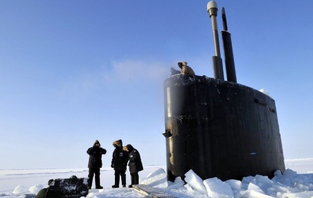
Climate Change Poses Major Challenge For U.S. Navy In The Arctic. As Arctic ice continues to thin (and countries around the world scramble to take advantage of this warming trend to drill for oil and natural gas), the U.S. Navy will be confronting new challenges in the years ahead. Here's an excerpt from an
article in the New York Times: "
Climate change will pose major new hurdles for U.S. naval forces, forcing the military to grapple with an emerging Arctic frontier, increasing demand for humanitarian aid and creating rising seas that could threaten low-lying bases, the National Academy of Sciences said yesterday. "Even the most moderate current trends in climate, if continued, will present new national security challenges for the the U.S. Navy, Marine Corps and Coast Guard," concludes a new academy report. "While the timing, degree and consequence of future climate change impacts remain uncertain, many changes are already underway in regions around the world ... and call for action by U.S. naval leadership in response." The analysis, conducted at the Navy's request, echoes similar reports authored by the Defense Department, the intelligence community and the Navy's own Task Force Climate Change. Much of its focus is on the far north, where rising temperatures are decreasing the portion of the oil- and gas- rich Arctic Ocean that is covered by sea ice. By 2030, ice-free periods during late summer could be long enough to create new sea lanes through the polar region, the new report says."
Reframing Climate Change: It's As Much Cultural As Scientific. Skepticism. Denial. Climate change transcends science and logic and becomes a psychological challenge. All of us are hard-wired to avoid bad news (especially if there is no short-term solution). Andy Hoffman at the University of Michigan's Ross School of Business has an
interesting take on the challenge and something he calls a "logic schism": "
ANN ARBOR, Mich.—While debate on climate change often strikes a caustic tone, the real impediment to meaningful dialogue is that the two sides often talk past each other in what amounts to a "logic schism," says a Ross School professor. "In a logic schism, a contest emerges in which opposing sides are debating different issues, seeking only information that supports their position and disconfirms their opponents' arguments," said Andy Hoffman, the Holcim (U.S.) Professor of Sustainable Enterprise at the Ross School of Business and U-M's School of Natural Resources and Environment. "Each side views the other with suspicion, even demonizing the other, leading to a strong resistance to any form of engagement, much less negotiation and concession." In a new study in this month's issue of the journal Organization & Environment, Hoffman provides a descriptive analysis of the cultural and social landscape of the climate change debate in the United States, examining the presence of ideological and cultural influences on both the definition of the problem and consideration of solutions. "The goal is to uncover whether competing logics within the broader climate debate represent a logic schism and, if so, whether that schism has reached such a point that it cannot be resolved," said Hoffman, associate director of the Erb Institute for Global Sustainable Enterprise. Hoffman treats the climate change debate as a series of competing movements engaging in "framing battles" over the interpretation of the problem and the necessity and nature of solutions. These frames include diagnostic (defining problems and assigning blame), prognostic (focusing on solutions) and motivational (explaining the need to act) collective action. These movements, he says, possess competing institutional logics regarding climate change---what Hoffman calls the "climate change convinced" and "climate change skeptical" logics. He is careful to distinguish between the extreme positions of climate change deniers and believers, who are fairly closed to debate and engagement, with the more central positions of the convinced and skeptical climate change populations."
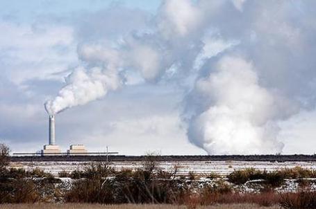
Climate Change Emergency: Time To Slam On The Brakes. Atmospheric warming and melting of Arctic (and Antarctic) ice is happening faster than previous simulations predicted. Here's an excerpt of a recent
article from James Wright at Skeptical Science: "
Right now we stand at an intersection. What we do in this decade is crucial. If we choose one path, by the end of the decade the world could be well on its way to phasing out coal. If we choose the other, we face an uncertain future in which the only certainty is a continually shifting climate. I'll leave the final word to Hansen et al, whose concluding statements were pretty strongly worded coming from a dense, technical, peer-reviewed paper:
"Present policies, with continued construction of coal-fired power plants without CO2 capture, suggest that decision-makers do not appreciate the gravity of the situation. We must begin to move now toward the era beyond fossil fuels. [...] The most difficult task, phase-out over the next 20-25 years of coal use that does not capture CO2, is Herculean, yet feasible when compared with the efforts that went into World War II. The stakes, for all life on the planet, surpass those of any previous crisis. The greatest danger is continued ignorance and denial, which could make tragic consequences unavoidable."
Could Climate Change Be Increasing The Risk of Major Quakes? I know - there's a major disaster and everyone piles on, trying to connect the dots with sometimes outlandish theories. Who or what can we blame? When I first read this
article I thought "well, that's a stretch." I have no idea if there's a potential link between rising sea level and global ice-loss and an increasing risk of tremors, but try to follow this guy's logic: Not sure about this one. "
So far, today's tsunami has mainly affected Japan -- there are reports of up to 300 dead in the coastal city of Sendai -- but future tsunamis could strike the U.S. and virtually any other coastal area of the world with equal or greater force, say scientists. In a little-heeded warning issued at a 2009 conference on the subject, experts outlined a range of mechanisms by which climate change could already be causing more earthquakes, tsunamis, and volcanic activity. "When the ice is lost, the earth's crust bounces back up again and that triggers earthquakes, which trigger submarine landslides, which cause tsunamis," Bill McGuire, professor at University College London, told Reuters. Melting ice masses change the pressures on the underlying earth, which can lead to earthquakes and tsunamis, but that's just the beginning. Rising seas also change the balance of mass across earth's surface, putting new strain on old earthquake faults, and may have been partly to blame for the devastating 2004 tsunami that struck Southeast Asia, according to experts from the China Meteorological Administration."


No comments:
Post a Comment