100 days: average number of days every winter with at least 1" or more of snow on the ground at MSP.
127 days: number of days with 1" or more of snow this winter season.
.02" rain predicted for Wednesday in St. Cloud as a cold front arrives (NAM model).
62 F. high temperature reported at St. Cloud on Monday (average high is 55 F).
64 F. high predicted later today in St. Cloud.
41 F. predicted high for Friday. Temperatures may hold in the 30s much of the day as rain changes over to wet snow.
"Few Inches" of snow very possible late Friday and Friday night over far southern MN. as a strong storm passes south/east of Minnesota.
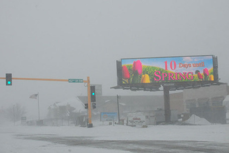
August 29. Today the sun will be as high in the sky as it was in late August. Any snow that might fall late in the week won't linger on the ground for long.
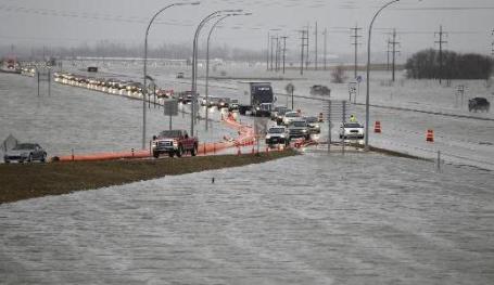 Red River Becomes The Red Sea. An update on historic flooding underway in the Red River Valley from the Star Tribune: "FARGO, N.D. - The Red River Valley reverted to a shallow sea Sunday as tributaries of the Red River, stalled by that river's massive flow through the Fargo-Moorhead area, spread across the landscape, flooding homesteads and closing highways. An estimated 60 roads in North Dakota's Cass County were closed as floodwaters rushed across them, and a roughly 8-mile stretch of Interstate 29 north of Fargo was closed in both directions late Sunday afternoon. Where the interstate was still open, whitecaps rolled up to the edges of the pavement as strong northwest winds roiled the floodwaters. Cass County administrator Bonnie Johnson described the overland flooding as "unprecedented." Roads could remain closed for more than a week. In rural Argusville, north of Fargo, the Coast Guard, sheriff's offices and National Guard had to pluck stranded farm residents from the watery countryside."
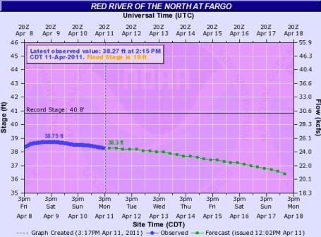 Starting To Recede. After cresting around 38.75 feet, the Red River at Fargo is beginning to fall. Click here to see more details, courtesy of NOAA's North Central River Forecast Center.
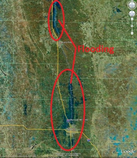 Red River Flooding From Space. An update from the University of Wisconsin meteorology department: "A MODIS false color Red/Green/Blue (RGB) image from the SSEC MODIS Today site (above; courtesy of Kathy Strabala, CIMSS) showed the areal extent of the unprecedented overland flooding that was occurring along parts of the Red River in North Dakota on 11 April 2011. Spring snow-melt along with recent heavy rainfall were contributing to the flooding. Interstate 29 north of Fargo was closed due to water covering the roadway."
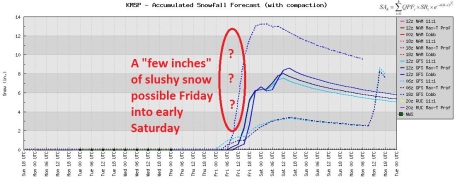 Too Early To Panic (Much). The GFS has had its issues in recent weeks, but the trend is pretty clear: a rain/snow mix will (in all probability) change to mostly snow late Friday and Friday night, tapering to flurries by Saturday morning. How much? Too early to say with any certainty, but a "few inches" of slush can't be ruled out Saturday night, especially south of the Twin Cities. I still don't want to believe that 10-12" of snow could fall during the 3rd week of April. Then again, this is Minnesota; we just muddled through the snowiest winter since 1983-84, and we're still in a fairly volatile pattern. It's still early - let's take in a few more computer runs before we schedule a therapy session.
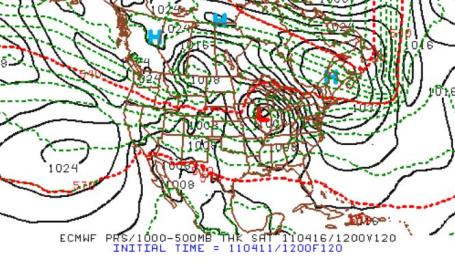
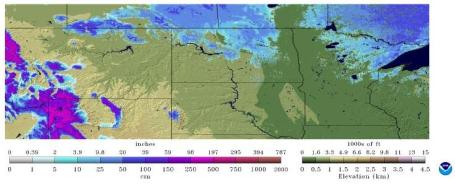 Snow Cover. Between recent rain and warmth there isn't much snow left across the state, still 4-12" along the North Shore of Lake Superior. Click here to see the latest data, courtesy of NOAA's NOHRSC Interactive Snow Analyses.
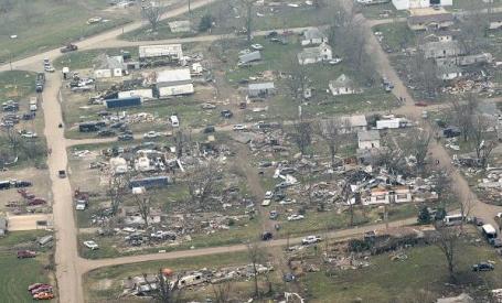 Mapleton Tornado Damage. Here are some amazing images from the Sioux City Journal. As many as 2 separate funnels may have descended on this small town in western Iowa. It was confirmed as an EF-3 tornado, estimated winds over 160 mph. "Destruction in Mapleton, Iowa, is shown in this Sunday, April 10, 2011, aerial photo. The small town was hit by a tornado Saturday night, April 9. Sioux City Journal photo by Tim Hynds."
Iowa Tornado Recap. Click here to see more details about the swarm of tornadoes that swept across western and northwestern Iowa on Saturday; some EF-3 in strength.
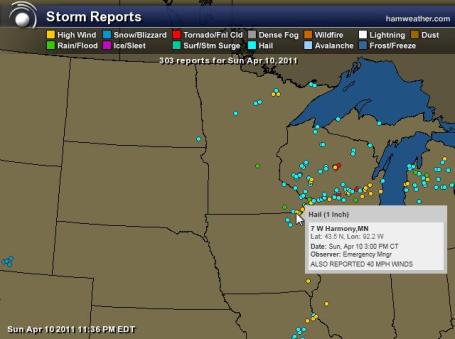 Sunday Storm Reports. Click here to see an interactive map from Ham Weather with details on the hail, high winds and isolated tornadoes reported from Sunday's squall line.
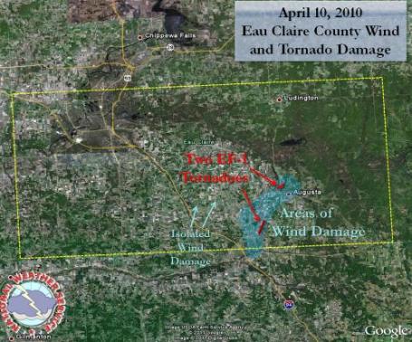
At Least 2 Tornado Touchdowns Near Eau Claire, Wisconsin. The local NWS has a summary of Sunday's severe weather outbreak:
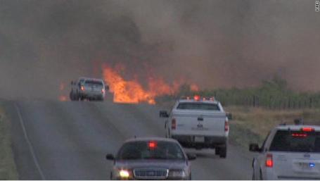
Firefighters Battle To Contain Texas Wildfires. Severe drought conditions have helped to fan historic brushfires across Texas; here's an update from CNN: "Crews bolstered by out-of-state help worked in Texas on Monday to contain large wildfires responsible for destroying close to 100 homes and other structures, officials said. "We are all doing the best we can," said Lisa Nugent, director of the Chamber of Commerce in Fort Davis, where the Texas Forest Service said fire has already destroyed 40 to 50 homes. "We have firefighters from all over the country." She said it is too early for people to come to look at the damage. "We don't want people coming back or visiting," Nugent said. The town is still in an "imminent danger of fire," with several fires still burning nearby. "I can see black smoke behind the courthouse," she said. The fire in Presidio County has grown to 80,000 acres with only 10% containment, the Forest Service said early Monday. That growth, according to fire operations chief Mark Sanford, came after the fire "made a 12-mile run on Saturday." Officials still don't know what caused the fast-moving fire, he said."
 48 Foot Waves Hits Nuclear Power Plant. TEPCO releases video of 48-foot wave that crippled Japana's Fukushima Daiichi power plant, video clip courtesy of CNN.


Bee Die-Off Threatens Global Food Calamity. I don't pretend to know why there have been so many reports of dying fish and birds falling out of the sky, but the die-off could present a major problem to the food supply. More details from goldseek.com: [This essay, by Cam Fitzgerald, a frequent contributor to Ricks Picks, is a stark reminder that we could soon be facing problems far more serious, even, than the collapse of the economy. For in fact, the alarming die-off of bumblebees and other cross-pollinators that Cam has written about could presage the devastation of food supplies around the world. Cam, a beekeeper himself, warns that, unlike global warming, which is happening slowly, the death of hives around the world has been so precipitous that a solution needs to be found and implemented soon, lest the food chain suffer catastrophic and irreparable harm. Although a pesticide called Clothianidin is suspected, we don’t have time for endless political debate. Time is running out, and that is why I would urge readers to spread awareness of the problem by disseminating a link to this commentary as far and wide as possible.]

Update On Massive Fish Kill In Redondo Beach, California. Yes, those are (dead) fish in the photo above. The L.A. Times has more information: "Authorities in Redondo Beach are investigating what killed millions of fish over the last day at King Harbor Marina. Fish, including anchovies, sardines and mackerel were floating lifeless in Basins 1 and 2 of the north side of King Harbor Marina."
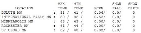


Paul's SC Times Outlook for the Twin Cities and all of Minnesota:
TODAY: Plenty of sun, feels like spring. Winds: SW 10-20. High: 64
TUESDAY NIGHT: Clouds increase. Low: 43
WEDNESDAY: Cooler, few rain showers likely. High: 54
THURSDAY: Intervals of sun, cooler breeze. Low: 33. High: 51
FRIDAY: Cold rain changes to snow, some accumulation is possible (especially on lawns/fields) by Friday night. The heaviest bands of snow will probably stay south/east of St. Cloud. Low: 32. High: 41
SATURDAY: Couple inches of slush early? PM clearing. Low: 30. High: 49
SUNDAY: Clouds increase, whatever snow falls Friday-early Saturday should be gone. Low: 32. High: 51
MONDAY: More clouds than sun, still unsettled. Low: 37. High: 55
Cruel & Unusual
For the record: 1). I'm just the messenger. 2). I'm looking forward to spring as much as you are. Maybe more. I like snow as much as the next Minnesotan, but I've had quite enough, thank you very much. An average April brings 3.1" snow to the Twin Cities. The last time a "plowable" snow fell during the latter half of April? 4.5" on April 28, 1994. We've been spoiled in recent Aprils, but this winter season was anything but "average".
Confidence levels are still low, but for the last 3 days/row long-range models have tracked a major storm just south/east of Minnesota late in the week. It may be just cold enough for snow, especially far southern Minnesota; a few slushy inches can't be ruled out by Friday night. Whatever falls will be GONE within 24 hours. The sun is just too high in the sky for snow in your yard to linger. Deep breaths. We're all going to need therapy. Again, right now it appears the brunt of the snow may stay just south/east of St. Cloud, but it's going to be another close call.
Balmy 60s today will give way to a cold front Wednesday; we'll be lucky to see 40 by Friday. Don't pack away the heavy jackets just yet.
During an average winter 1" or more of snow is on the ground 100 days. This winter season: 127 days. Someday we'll be telling our grand kids about the (real) Winter of '11. #@&?!!!
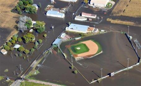
Changes In Climate, Land Use Help Trigger Heavier Flooding. The last 3 years have been the wettest in South Dakota history. Here's a story focusing on recent trends, from the Argus Leader: "Spring flooding in eastern South Dakota to some extent follows a fairly typical storyline: A wet fall and snowy winter saturated the soil and filled up the river basins, and when the spring melt came the water had nowhere to go. But officials say the rising incidence of flooding and wet weather also is part of a broader trend, one driven by climate change and perhaps by changes in land use, too. Combined, the past few years created the wettest three-year period on record in South Dakota, state climatologist Dennis Todey said. And scientists throughout the Upper Midwest are seeing the same trends and the same signals: higher low temperatures throughout the year; higher streamflows; and heavier, more varied and more frequent precipitation."There isn't any question that there's been more precipitation between the 90th and the 100th meridians, kind of a slice in the middle of the country," said Mark Anderson, director of the U.S. Geological Survey Water Science Center in Rapid City. It's a wetness trend that shows a steadily upward if uneven slope, and it goes back decades, he said."

Q: Is global warming evident in the temperature records of Wisconsin for the past 30 or 40 years? Winters seem to be getting a whole lot warmer.
A: Indeed, and winter is actually warming faster than summer in Wisconsin, says Ankur Desai, an assistant professor of atmospheric and oceanic sciences at UW-Madison. "The annual average temperature has risen 1.1 degrees Fahrenheit, which is pretty consist with global trends, but what is different in Wisconsin is the strong increase in winter temperatures, of about 2.5 degrees in winter, and almost 4 degrees in the Northwest."
Extremely cold days are becoming less frequent, Desai adds: "The number of days below zero has decreased statewide; nighttime lows are not as low as they used to be. This winter, the Weather Service in Milwaukee reported there had been a record 723 days — virtually two years — since the last below-zero day. Even though Milwaukee does not get below-zero as much as Madison, this is still a pretty incredible stretch."
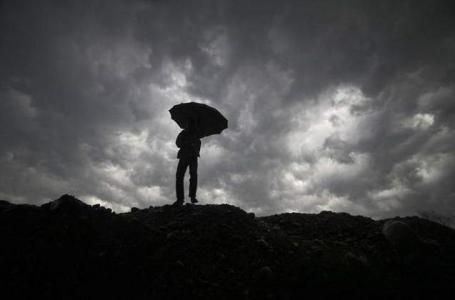 Tweaking The Climate To Save It: Who Decides? The subject of "geoengineering" makes my skin crawl. Let's make a bad situation worse by tinkering with the atmosphere! Here's a recent article from Gannett's marionstar.com: "CHICHELEY, England (AP) - To the quiet green solitude of an English country estate they retreated, to think the unthinkable. Scientists of earth, sea and sky, scholars of law, politics and philosophy: In three intense days cloistered behind Chicheley Hall's old brick walls, four dozen thinkers pondered the planet's fate as it grows warmer, weighed the idea of reflecting the sun to cool the atmosphere and debated the question of who would make the decision to interfere with nature to try to save the planet. The unknown risks of "geoengineering" - in this case, tweaking Earth's climate by dimming the skies - left many uneasy. "If we could experiment with the atmosphere and literally play God, it's very tempting to a scientist," said Kenyan earth scientist Richard Odingo. "But I worry." Arrayed against that worry is the worry that global warming - in 20 years? 50 years? - may abruptly upend the world we know, by melting much of Greenland into the sea, by shifting India's life-giving monsoon, by killing off marine life."
 The Seasons Shift: How Spring Is Coming Earlier Thanks To Global Warming. The evidence is there for people keeping an open mind (and observing cues from nature). The U.K. Mail Online has an article focusing on the shifts observed in England: "The leaves of the English oak are appearing sooner, meaning that winter moths are coming out earlier and, because the birds that eat them are still flying north, they have already turned from caterpillars and into moths. Their research is matched by that of researchers in Korea tracking cherry blossom and the U.S., which records its findings at the Smithsonian Institution's National Herbarium every year. A 2005 analysis of 100 of the most popular flowers, 90 bloomed up to 44 days sooner than they did 20 years ago, according to the Washington Post. 'There is always variation from year-to-year in nature. 'And I don’t want to sound alarmist that spring is coming earlier and earlier,” said Fleming, who is in her 70s. “But, boy, every year, we do feel it.' Meanwhile Remote Sensing Systems has shown that March 2011 was the coolest March since 1994. It was 0.026C cooler than average - the first month that has been cooler than average since June 2008. Ms Fleming worries that plants' life cycles are speeding up. Her concern is that their insect pollinators won't be able to cope with the Earth's changing habitats."
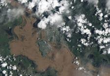


Climate Myths From Politicians. From Skeptical Science: This page features quotes from politicians who repeat debunked climate myths. Click on any politician to see a list of their quotes as well as what the science says about their climate myths.
No comments:
Post a Comment