69 F. yesterday in St. Cloud.
70 F. reported at International Falls,
71 at Brainerd.
.00" rain predicted today (NAM model).
.37" liquid precipitation predicted by 7 am Saturday. Most of that will fall as rain Friday, but a changeover to wet snow is still possible late Friday night into a portion of Saturday, still a potential for 1/2 to 2" of slush in the St. Cloud metro area.
Top April Snowfalls in the Twin Cities (source: National Weather Service)
1).
13.6" April 15, 1983
2).
13" April 27-28, 1907
3).
10" April 20-21, 1893
4).
9.7" April 29039, 1984
5).
9.4" April 6-7, 1923
* Most recently, 1983 and 1984 were pretty tough Aprils in the snow department. Since then we've been (mostly) spoiled.
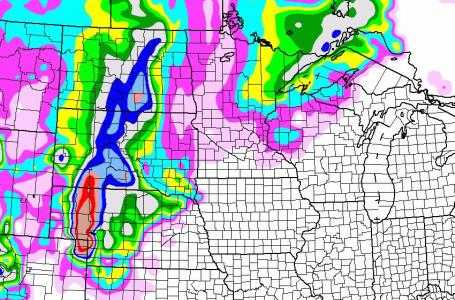
 Dodging A Snowy Bullet?
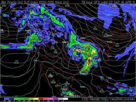
 It's still early (the storm is still 48-60 hours away), but the most recent model runs take an intense area of low pressure farther south/east, on a track across Missouri into Illinois. The eastern Dakotas may still wind up with 6-12" of heavy wet snow, with 2-5" for southwestern Minnesota, but the GFS prediction (above) backs off considerably on expected snowfall amounts across the metro region.
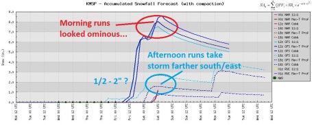 My Blood Pressure Is Coming Down (so should your's)
. The fate of this upcoming storm is by no means sealed, but the trend is pretty undeniable. The 12z runs were printing out anywhere from 7-9" of snow, but the 18z Tuesday model runs backed (way) off on amounts, hinting at (maybe) an inch or two, if that. We'll see, but the odds of a staggering amount of snow seem to have come down.
 Southerly Track
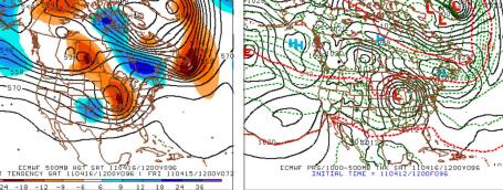
. All the models seem to be coming around to the European (ECMWF) solution, closing off the low aloft, keeping the track 100-200 miles farther south. The heaviest precipitation bands are forecast to set up across Iowa, far southeastern MN, southern Wisconsin and northern Illinois, where temperatures aloft may be warm enough for mostly-rain.
 Close Call
. I'm still nervous - come to think of it to be a meteorologist (in Minnesota) is to be perpetually nervous. Friday's storm will be powerful, loaded with moisture from the Gulf of Mexico. A cold rain during the day Friday may still mix with - or change over to - a period of wet snow Friday night and early Saturday before tapering off. That said, the storm track is still forecast to be a little close for comfort...
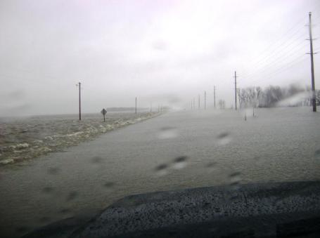
Widespread - Unprecedented Flooding. From the Grand Forks office of the
NWS: "
Widespread, and in some areas, unprecedented overland flooding is occurring in Cass and Clay county. The greatest concern is near the confluence of the Rush, Maple and Sheyenne Rivers in and near Harwood. Rainfall over the last 24 hours has also added to the flooding threat, and flooding will continue for the foreseeable future. Interstate 29 north of Fargo has also been close dto to water over the road. Water levels will remain high as continued high flows come into this area."
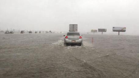
Red River Valley Flood Fight Shifts North Of Fargo. USA Today has an
update on the crest, which continues to spread northward into Canada - it was the 4th greatest crest of the Red River in Fargo ever recorded: "
The Red River Valley flood fight shifted Sunday from the cities of Fargo and Moorhead, Minn., to rural areas north of the north-flowing river, which crested Saturday night in Fargo at its fourth highest level in recorded history. Fargo officials said the metropolitan area appears to be in good shape, but urged residents not to travel outside the city. About 60 miles of roads were closed in Cass County, where Fargo is located, and another 10 miles of roads were washed over, officials said. Interstate 29 north of Fargo was closed for about 25 miles. Some tributaries of the Red River were at record levels. "In the southern part of the valley, it's quiet," Fargo Mayor Dennis Walaker said Sunday. "In the northern part of the valley, especially in Cass County, they're having extreme problems." About 425 National Guard members were on duty in Cass County and were ready to help with evacuations if needed, North Dakota Gov. Jack Dalrymple said Sunday. He said there haven't been "many very serious situations," but officials were monitoring the rise of overland flooding."
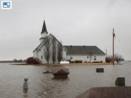
"Never Been This Bad", North Dakotan Says. The immediate Fargo area avoided a worst-case scenario, but extensive flooding has been reported elsewhere across the Red River Valley. The New York Times has a good
summary: "
Along the Red River Valley, severe flooding has become a rite of spring in recent years. In Cass County, N.D., which encompasses Fargo, smaller rivers that normally feed into the Red River have backed up, shutting down roads, swamping entire communities and turning huge areas of farmland into huge lakes. “It’s dozens of square miles, at least,” said Greg Gust, a meteorologist with the National Weather Service. Residents who are used to waiting out the flooding have been evacuated by boat and helicopter — one rescue required a five-mile boat trip to reach the stranded homeowner. “It has never been this bad,” said Bonnie Johnson, the county administrator. Three deaths have been attributed to the flooding, officials said. An elderly farmer suffered a heart attack after loading sandbags, and two beaver hunters drowned when their boat overturned on a flooded tributary."
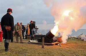
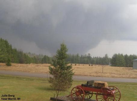
Merrill, Wisconsin Tornado. Here is a photo of the April 10 tornado looking south toward Merrill, WI, courtesy of Julia Berg and
Twitpic.
Details From The National Weather Service:
...BIGGEST APRIL TORNADO OUTBREAK IN WISCONSIN HISTORY...
APRIL 10 2011 WILL GO DOWN AS ONE OF THE BIGGER TORNADO OUTBREAKS IN
WISCONSIN HISTORY. IT IS TIED FOR THE BIGGEST TORNADO OUTBREAK IN
TERMS OF NUMBERS OF TORNADOES IN ONE DAY IN THE MONTH OF APRIL
(APRIL 27 1984-WALES F4 IN WAUKESHA COUNTY)
SO FAR...AT LEAST 10 TORNADOES HAVE BEEN CONFIRMED AS THREE NWS
OFFICES ARE COMPLETING STORM SURVEYS.
HERE ARE THE TORNADO TOTALS SO FAR:
NWS GREEN BAY AREA: 7*
NWS LA CROSSE AREA: 2
NWS TWIN CITIES AREA: 2
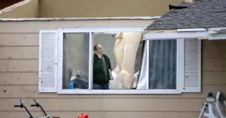
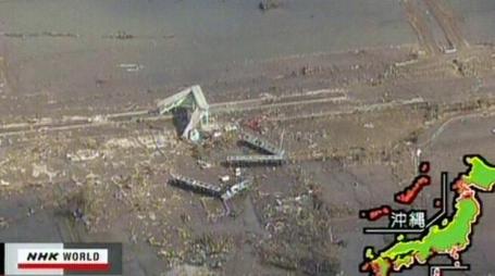
Tornado Damage Heavy In Iowa And Wisconsin. We dodged a bullet over the weekend, severe weather skirted Minnesota, but Iowa and Wisconsin were hit hard, as
reported by the New York Times: "
Fred Standa, the mayor of Mapleton, Iowa, was sitting on his porch Saturday watching the black cloud boiling up from the horizon when storm sirens blared a warning through town. Suddenly the cloud spit out a tornado funnel into the empty farmland. “Like everyone says, it sounds like a freight train coming towards you,” he said. “But I didn’t wait around to listen.” The tornado, which hit at 7:20 p.m. and was later identified as a Category 3 tornado with winds as high as 165 miles an hour, was the largest of 27 reported in Iowa on Saturday, said a spokesman for the National Weather Service. There were no fatalities. The following day, seven tornadoes were reported in Wisconsin. One tore through a section of Merrill, destroying 50 to 60 buildings and scattering debris for miles, said Bob Odegard, the fire chief." (photo above from Kaukauna, Wisconsin).
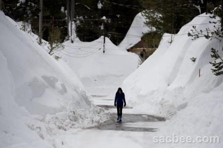
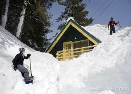
Surreal Amounts Of Snow.Year-round residents of Serene Lakes (near Tahoe) have opted not to evacuate, in light of recent propane leaks. 60-65 feet of snow in recent months has had some unintended consequences for people trying to stay put and ride out the snow-blitz, as
reported by the Sacramento Bee: "
More than 20 propane tanks were still leaking Monday evening, and a voluntary evacuation initiated over the weekend remained in effect for Placer County's Serene Lakes subdivision. But year-round residents said they were staying put, despite concerns about explosions like one that leveled a three-story home in the mountain enclave near Soda Springs on Friday night. "The main issue is for people who are not (year-round) residents," said Malinda Caven, a six-year resident of Serene Lakes who said she makes a point of keeping snow from piling up on her propane tank and lines leading to her house. Richard Simmons, program manager for the Placer County Office of Emergency Services, said 28 leaks have been reported on the county's east slope, and as of late Monday afternoon, six of those had been repaired."
Japan's Public Broadcaster Responds, Reports Crisis. NPR has an
update on the possible conflict of interest at NHK, Japan's premier broadcaster, in the reporting of the Fukushima nuclear crisis: "Of all the Japanese institutions that respond to emergencies, few are so crucial in saving lives as the broadcasters who warn ordinary citizens of the impending calamity. Much of that task falls to NHK, the nation's public broadcaster. Every night, NHK journalists rehearse emergency broadcasts so that they respond to disasters instinctively. It's a key part of NHK's journalistic mission, but what happened at 2:46 p.m. on March 11 was no drill. Within seconds of a warning from meteorological authorities, NHK interrupted a live broadcast from Japan's Parliament. "This is an emergency earthquake announcement," an announcer read, following an alarm sound to indicate an earthquake warning. Nervous lawmakers looked up as the quake began and chandeliers in the room began swaying and clinking.
Physicist Reviews Nuclear Meltdowns. In a relative sense, the USA has been very lucky with it's civilian nuclear track record, compared to the rest of the world.
Details from the New York Times: "
The three partial Japanese nuclear meltdowns bring the worldwide total to a dozen accidents with reactor core damage since the first one in 1957, and nuclear reactors worldwide are suffering such accidents about eight times more frequently than the United States’ safety goal, an American physicist said. Thomas B. Cochran, a Natural Resources Defense Council scientist, looked at 12 accidents — four in the United States, two in France, one each in Scotland, East Germany and Ukraine, and the three in Japan. He excluded one accident, SL-1, an experimental United States Army reactor that was being tested 50 years ago as a remote power source for radar in the Canadian Arctic to watch for a Soviet nuclear attack. Among the dozen reactors, it was the only one not connected to the power grid."
The Story Of The World-Record Wind. Yesterday marked the anniversary of the strongest (surface) wind observation since modern-day records have been kept: 231 mph on the summit of Mt. Washington, New Hampshire, on April 12, 1934. More
details from the Mt. Washington Observatory: "
The pieces were coming together for a major weather event. On this day, the ridge over the Atlantic and the storm over the eastern Great Lakes had become even stronger. More importantly, the pressure gradient between these two systems was extremely tight on the northeast portion of the low. This was causing very strong and extremely rare southeast winds. "I dropped all other activities and concentrated on observations. Everyone in the house was "mobilized' as during a war attack and assigned a job. The instruments were watched continuously so that they may give a continuous and accurate record of the various meteorological elements at work. The anemometer was particularly watched. A full tank of gasoline made us feel good." - Log Book entry, Sal Pagliuca As the day wore on, winds grew stronger and stronger. Frequent values of 220 mph were recorded between Noon and 1:00 pm, with occasional gusts of 229 mph. Then, at 1:21 pm on April 12, 1934, the extreme value of 231 mph out of the southeast was recorded. This would prove to be the highest natural surface wind velocity ever officially recorded by means of an anemometer, anywhere in the world. "'Will they believe it?' was our first thought. I felt then the full responsibility of that startling measurement. Was my timing correct? Was the method OK? Was the calibration curve right? Was the stopwatch accurate?" - Log Book entry, Sal Pagliuca"
 Weather As A Decisive Factor In The Civil War
. Still with me? Got a little time to kill? Check out this vaguely interesting
story from Accu Weather about the weather's impact on the ultimate outcome of the Civil War. From Napolean to Hitler's march on Moscow to Operation Desert Storm, weather has been a huge factor in war. "
Although weather records and information this far back in history is hard to come by, several notable weather events during the war have survived the decades. The book Washington Weather chronicles two particular weather events during the War Between the States. On Jan. 20-23, the Union Army encountered a strong nor'easter, one that completely halted the Army of the Potomac. However, it wasn't heavy snow that stopped the troops; it was mud. "The weather had been fairly dry and mild for most of January and the prospects for a winter campaign seemed good," the account reads. Little did they know a storm was brewing southeast of them. A classic nor'easter moved up the East Coast and hit the army. Since temperatures were in the 30s, rain fell instead of snow. It did not take long for General Burnside's troops to be bogged down in mud. Wagons and cannons became stuck, and many soldiers fell in the mud and lost their shoes. The troops had no choice but to abandon their mission and return to camp. Upon their arrival, they found their shelters flooded. According to Washington Weather, 3.2 inches of rain fell in Washington, D.C."
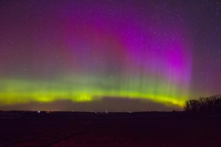
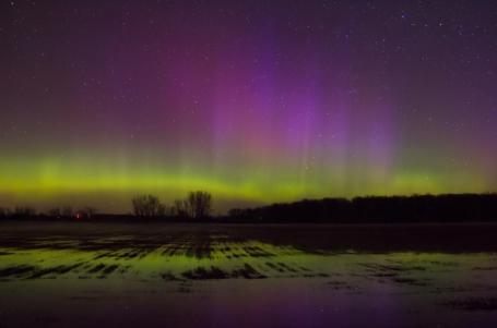
A Spectacular View Of The Northern Lights. Thanks and a tip of the hat to Doug Kiesling over at
stormchasingvideo.com for passing on these amazing photos of the Aurora Borealis. According to Kiesling, "these photos were shot on the north side of St. Cloud around 4:30 am. The first is a field with the auroras above them. The second (photo) is a flooded field reflecting the auroras in the water." Amazing.
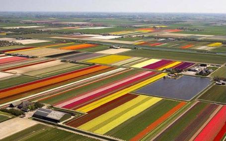
Tulip-Mania! Friend and colleague Todd Nelson passed on these photos of tulip fields, which I thought you might want to see (to take your mind off the s-word in Friday's outlook). Yes, we all need a mental health break: "At first glance it looks like a giant child armed with a box of crayons has been set loose upon the landscape. Vivid stripes of purple, yellow, red, pink, orange and green make up a glorious patchwork. Yet far from being a child's sketchbook, this is, in fact, the northern Netherlands in the middle of tulip season. The Dutch landscape in May is a kaleidocope of color as the tulips burst into life. The bulbs are planted in late October and early November. More than 3 billion tulips are grown each year, and two-thirds of the vibrant blooms are exported, mostly to the U.S. and Germany. Their dazzling colors are thanks to the years in the 17th century when tulip mania swept the globe and the most eye-catching specimens changed hands for a small forture. But like a Rainbow, this colorful landscape is a short-lived phenomenon. When the flowers are gone, the land will be cultivated for a crop of vegetables. The Netherlands produce more than 9 million bulbs a year.
.
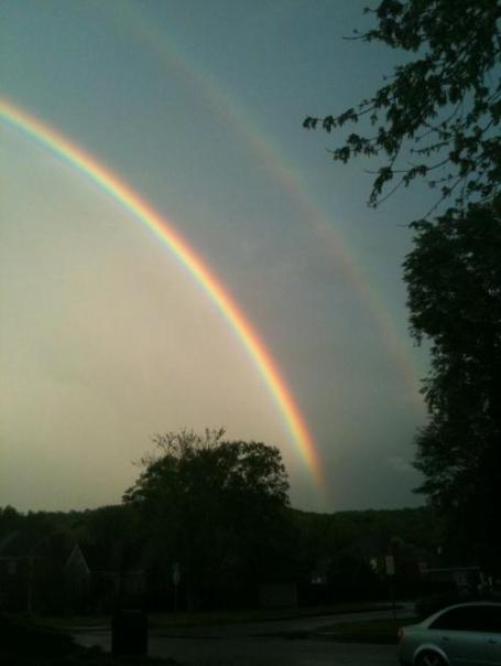
Here's an interesting post from Dan Satterfield at the AGU Blogosphere that caught my eye: "
We had some nice storms rumble through North Alabama this evening and, just at sunset, the storms passed Huntsville. I expected to receive some rainbow pics and I was not disappointed! A double rainbow is reversed, of course, from the primary but in between the sky will look a little darker. You can see it clearly in the picture on the right. This was first described by Alexander of Aphrodisias around 200 CE. Alexander is famous for his many commentaries on the works of Aristotle, who lived over 500 years before. You can read more about it on Les Cowley’s excellent atmospheric optics site here."
How Genius Works. I stumbled upon
this article in The Atlantic, a publication that I have more and more respect for over time (they have some amazing articles - it's worth
checking out). "
Great art begins with an idea. Sometimes a vague or even bad one. How does that spark of creativity find its way to the canvas, the page, the dinner plate, or the movie screen? How is inspiration refined into the forms that delight or provoke us? We enlisted some of America’s foremost artists to discuss the sometimes messy, frequently maddening, and almost always mysterious process of creating something new. "
 Eagle-Cam
. If you haven't checked this
U-Stream live video feed out yet - it's worth a look: "The
Raptor Resource Project brings you the Decorah Eagles from atop their tree at the fish hatchery in Decorah, Iowa. The live video feed is streamed online 24/7. At night an infrared light provides night vision to viewers through the cam.
Infrared light is not visible to eagles, they do not see it or know it is there.
First hatch 4/2/11.
24-hour collage of first egg pip and hatch
Second hatch 4/3/11.
First glimpse of second hatchling
Third hatch 4/6/11.
Close-ups of the third hatch

 Now That's More Like It
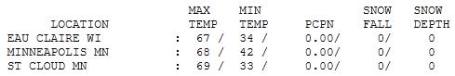
. If you didn't develop a twinge of spring fever yesterday I fear you may not have a pulse. What a remarkable display of April at its finest! International Falls warmer than the Twin Cities? 70 at INL, a respectable 68 at MSP,
St. Cloud reported 69 degrees, with a balmy 71 at Brainerd (in spite of being surrounded by ice-covered lakes).
Paul's SC Times Outlook for St. Cloud and all of central Minnesota:
TODAY: Cloudier, breezy and cooler. Passing shower or sprinkle possible (most of the day should be dry). Winds: N 10. High: 51
WEDNESDAY NIGHT: Partly cloudy and chilly. Low: 35
THURSDAY: Sunny start, clouds increase. Rain possible late at night. High: 45
FRIDAY: Heavy jackets return. Cold rain likely. High: 41 (temperatures may hold in the upper 30s much of the day)
FRIDAY NIGHT: Possible changeover to wet snow. Low: 31
SATURDAY: A slushy coating early? Any snow tapers to flurries - clearing late. High: 44
SUNDAY: Any snow in your yard quickly melts, peeks of sun likely. Low: 30. High: 47
MONDAY: More rain (wet snow north?) Low: 34. High: 49
TUESDAY: Lingering clouds, still damp. Low: 38. High: 53
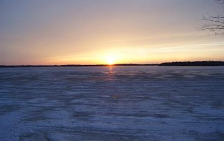
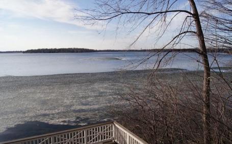 Before And After
. The photo up top was taken last week, still plenty of ice left on Tonka Bay. The photo at the bottom was snapped yesterday, while wearing a t-shirt (and a smile that wouldn'g to away). I know it's going to get colder, it may snow (a little) Friday night. So what. Yesterday ALMOST
made up for 84.7" of snow. Almost. I
can't think of another place on the planet (except for Siberia?) where the locals appreciate 70 more than right here in Minnesota.
Go ahead and Exhale
On April 15, 1983 local residents were depressed, fuming; a handful of people apoplectic with weather-rage. 13.6" snow fell, setting a new April record. Normally stoic Minnesotans lose their sense of humor when it snows on their green, freshly-mowed lawns.
Let me cut to the chase: the odds of an outrageous amount of snow late in the week have diminished somewhat; it looks like the heaviest snow bands will pass south/east of the MSP metro area. A cold rain Friday mixes with wet snow Friday night; we may still wake up to an (annoying) coating of slush Saturday morning (coating to an inch or two?) South Dakota could wind up with over a foot, maybe 3-6" over far southeast MN.
That said, jackets stage a comeback in 48 hours - Saturday morning will bring back (cold/slushy) memories of February. After Tuesday's 60s, Saturday will look & feel like a cold slap across the face.
The sun angle is as high in the sky as it was in late August - any snow in your yard will magically vanish by Sunday afternoon. Really. The arrival of a cooler front sets off a few (rain) showers today. After some late-week weather-drama 50s return next week. Deep breaths. I don't expect a worst-case scenario. Whew....
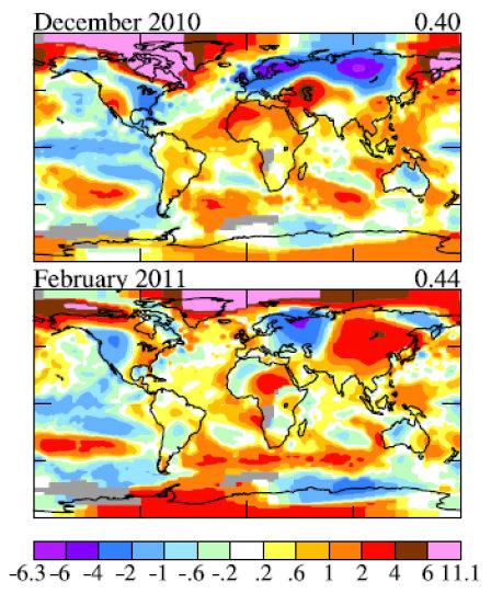
Arctic Warming "Smashes" NASA's Temperature Charts. It's gotten so mild over the Arctic that NASA had to reset the temperature scales they use.
More from good.com: "
Over at Climate Sight, Kaitlin Alexander noticed something curious about the maps in NASA scientist James Hansen's latest study. Temperatures have gotten so warm in the Arctic that Hansen had to reset the scale, adding a new color to the legend. Check out the hot pink on this chart from "Perceptions of Climate Change" (
PDF).
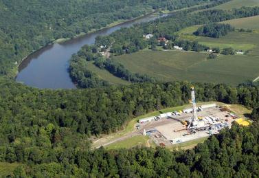
Natural Gas From Shale Worse For Global Warming Than Coal, Cornell Study Finds. There are no easy answers when it comes to energy sources - almost every alternative has positives and negatives, as reported by
pennlive.com: "
Natural gas from shale deposits such as the Marcellus has a bigger greenhouse gas footprint than coal, according to a study by researchers at Cornell University. The peer-reviewed study concludes, “The large green house gas footprint of shale gas undercuts the logic of its use as a bridging fuel over coming decades, if the goal is to reduce global warming.” That could have far-ranging consequences, especially in Pennsylvania, where most of the Marcellus Shale is located and where state legislators are actively promoting the conversion of transportation vehicles from diesel to natural gas. Industry groups immediately mocked the study as flawed and slanted, saying it was “an annual rite of spring” in Ithaca, N.Y., along with finals and farmer’s markets."
* If you're interested in seeing more details,
here is a fairly technical paper: "Methane and the Greenhouse-Gas Footprint of Natural Gas from Shale Formations". A little light reading...
Natural Gas As A Sustainable Energy Source? Lou Grinzo has some thoughts about natural gas and "fracking" on his
Cost of Energy blog:
- Humanity in general and certainly the US will use all the natural gas we can pull out of the ground for the next few decades. US use will be greatly encouraged by domestic fracked natural gas and the tendency for politicians to recite the “we can achieve energy independence” mantra, one of the stronger forms of political crack available today.
- Greenwashing via natural gas will reach staggering proportions, compared to what we’re already seeing from entities like Pickens, AT&T, car manufacturers, etc.
- Virtually no one will pay attention to the fact that such use won’t deliver anywhere near the savings in CO2 emissions we need. Witness my endlessly quoted statistic about CNG vehicles still emitting 75% of the CO2 of an equivalent gasoline powered car.
- We still don’t completely understand the ramifications of natural gas fracking, but given how adept we’ve already shown ourselves to be at ignoring the known issues, I have no doubt we’ll be able to overcome any future information that comes our way, no matter how horrible. The diffuse nature of the impacts of fossil fuels extraction and use, in contrast to the concentrated horror of nuclear power, make it all the more difficult to assess the true cost of using them. The fossil fuel companies could not ask for a greater gift from human psychology.
- Politicians and everyone else with a vested interest in resisting rapid change will continue to tout the reductions in our CO2 emissions from using “clean” natural gas, at least in absolute numbers. They won’t go anywhere near the percentages which will show we’re not just shifting our fuel reliance from one fossil fuel to another, but locking into one that leaves us substantially “above the curve” and therefore guarantees we’ll have no chance of meeting the necessary reduction goals.

. Andrew Freedman from the (excellent) Washington Post's Capital Weather Gang has a
well-written post that summarizes how I feel about the gridlock in Washington D.C., and the apparent willingess on the part of otherwise bright, logical, rational politicans to ignore global transformations in climate: "
Last week was a bewildering one for those who recognize the abundance of compelling scientific evidence showing that the climate is changing mainly due to human activities and that these changes pose risks to human health and welfare. While the news cycle was dominated by the down-to-the-wire budget negotiations in Washington, ongoing unrest in the Middle East, the nuclear crisis in Japan, a major congressional debate on climate change regulations took place in the House (and Senate) that vividly demonstrated how far off the rails we’ve gone in public discourse of climate science and policy. Let me state right off the bat that I tend to shy away from directly discussing politics in this column, instead sticking to scientific developments in the sprawling and fascinating field of climate research. At the same time, I recognize that climate science has become so politicized that it’s impossible to steer clear of politics entirely. This is understandable considering that many of the potential solutions to climate change could involve major policy changes, from federal regulations of emissions from cars, trucks, and power plants to a carbon tax on gasoline. The controversy surrounding the science is largely a front for concerns over potential regulation, as is vividly demonstrated in the book, “Merchants of Doubt”, by Naomi Oreskes and Eric Conway.
With the passage on April 6 of a bill that would stop the U.S. EPA’s regulations of greenhouse gases from moving forward, the House of Representatives signaled in crystal clear legislative language that it flat out does not believe that manmade climate change is a real phenomenon that poses risks to Americans’ health and welfare."
How The Koch Brothers Fund The Climate Denial Machine. Here's an excerpt of an
article in care2.com: "Charles and David Koch, known far and wide as the Koch brothers, are major funders of climate change denial campaigns.
Owners of Koch Industries, Inc., the brothers have a combined net worth of $44 billion. As a recent report by the Center for American Progress (CAP) puts it, "The Koch brothers make their money from an oil-and-gas conglomerate that emits pollutants that contribute to climate change. It should not be surprising, then, that the Koch brothers are also major contributors to organizations denying the effects of climate change." The CAP report cites a Greenpeace report which states that Koch Industries is "now playing a quiet but dominant role in a high-profile national policy debate on global warming." Koch Industries, through its foundations, gave $24.9 to "organizations of the climate denial machine." Koch Industries also fought the climate change bill, the American Reinvestment and Recovery Act of 2009. The Koch brothers inherited Koch Industries, Inc. from their father, Fred. C. Koch who started the company. The brothers also inherited their conservative politics from their father. Fred Koch was an original member of the John Birch Society."


No comments:
Post a Comment