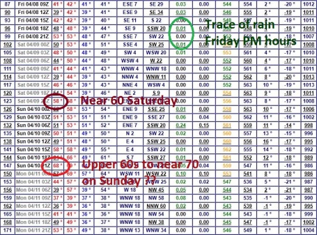
Decent Weather For Opening Day At Target Field? April 8 in the Twin Cities - what can possibly go wrong? A period of rain Thursday night may leave some jumbo-puddles first thing Friday, but the main frontal boundary is forecast to lift north of the Twin Cities, by midday rain falling over far northern Minnesota. Clouds may give way to peeks of sun with mid/late afternoon temperatures in the mid to upper 50s. 60 is not out of the question. Considering we could be knee-deep in snow, 50s on Opening Day doesn't sound too bad, not after the winter we just endured.
Instant Spring? The latest computer runs looks significantly warmer for the weekend, a chance of 60 Saturday afternoon, at least one model suggesting upper 60s to near 70 Sunday as a surge of southern warmth and moisture reaches Minnesota - a vigorous area of low pressure tracking northward across Iowa, unseasonably warm air wrapping into the circulation. I want to see a few more model runs, but there's a chance of unseasonable warmth this weekend. Coupled with more rain the result may be accelerated snow melt over northern and western Minnesota, increasing the flood potential on our streams and rivers. I suspect a second major crest may be a couple weeks away - that's just my hunch, not the official NOAA outlook.
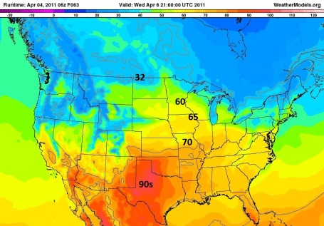
Wednesday Warmth. A few of the models are hinting at upper 50s to near 60 as early as tomorrow, again Saturday, more like late April weather. This temperature forecast map above is valid 3 pm tomorrow. Not sure we'll see 60, but mid to upper 50s seem likely.
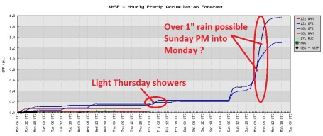
Thursday Showers - Major Storm Early Next Week? Right now it appears that a southern storm may just brush southeastern Minnesota (and the Twin Cities) with a period of light rain late Thursday and Thursday night. We may wake up to puddles, but odds favor a mostly-dry day Friday, again on Saturday. Confidence levels are still low, but latest models bring over 1" of rain into the Twin Cities Sunday PM hours into Monday.
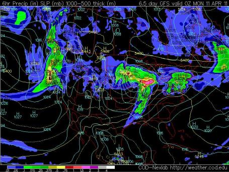
Have A "Plan B" (Indoors) For Sunday. It's still early to be getting specific about weekend plans, but there's little doubt that Saturday should be the sunnier, drier (nicer) day once again. A southern storm is forecast to spread a shield of light to moderate rain into Minnesota during the afternoon hours Sunday, potentially heavy rain Sunday night into a portion of Monday. The map above is valid around the dinner hour on Sunday, according to the (fairly unreliable) GFS model.
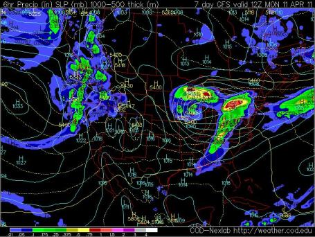
Monday Mix? The GFS is now falling in line with the ECMWF (European) model, bringing a major storm across the Plains into Iowa and Wisconsin. Enough warm air will probably wrap around this (intense) area of low pressure for a cold rain over much of eastern Minnesota, but wet snow could mix in over central/western Minnesota late Sunday night into Monday. It's still WAY too far out on the horizon for any precision (or confidence), but know there's a least a chance of a heavy rain/snow mix early next week.
Confirmation Of A (Very) Soggy Monday? The ECMWF, which tends to often do a better job than America's global GFS model, also pulls an intense area of low pressure into Iowa by Monday morning around the breakfast hour (when this map is valid). 850 mb winds (about 3,500 feet above the ground) are forecast to blow at 50-60 mph (sustained). If snow does mix in over the eastern Dakotas and western/northern Minnesota, visibilities could be quite low with surface winds in the 20-30 mph range. That's still pure speculation - but we've had a few ECMWF runs/row printing out basically the same solution.
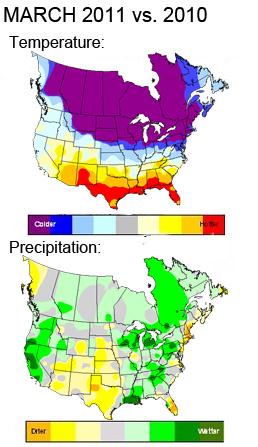
March 2011 vs. March 2010. Oh what a difference a year makes, according to the meteorologists at Planalytics, outside Philadelphia. March over America's northern tier states was 10-20 degrees colder than March of 2010. It's also been significantly wetter from Minnesota into the Great Lakes states - the result of a lingering La Nina cooling trend in the Pacific.
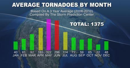
Tornado Season. Across the USA tornado season peaks in May, when an average of 322 tornadoes form in the skies over America. Here in Minnesota prime-time for tornadoes is June. In a recent 3 year period (2008 - 2010) tornadoes were observed every month of the year. Data courtesy of NOAA's Storm Prediction Center.
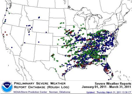
Tornado Count: 187. All those red dots are confirmed tornado touchdowns so far in 2011: 187 from January through March (this doesn't include tornadoes since April 1). Although close to average, to date, it's more than 3 times more tornadoes than we experienced in 2010 during the first 3 months of the year. More details from SPC
here.
A Volatile Spring Season For Severe Weather. Accu Weather has
more on what is turning into a much more active spring for tornadoes, hail and damaging straight-line winds than last year at this time: "
While the number of severe thunderstorms typically increases during April, this month could be especially nasty, when compared to other years. Much of the U.S. will continue to experience huge temperature swings this April. The magnitude and frequency of these swings will be like ringing the dinner bell for severe weather. The temperature swings are brought on by the passage of a surface front. However, it is the steering winds high overhead, known as the jet stream, that helps push the fronts along and help generate the high winds in severe thunderstorms. We cannot say that the presence of a La Nina directly increases the number of severe thunderstorms and tornadoes. It does, however, strengthen the polar jet stream and which could have an indirect effect on the number and frequency of severe weather outbreaks."
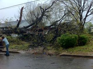
Damaging Storms. Either a small tornado or straight-line winds (in excess of 80-100 mph) downed these trees outside Nashville, trapping several residents inside their homes. Photo courtesy of Twitpic.
Severe Monday. A fast-moving squall line of severe thunderstorms may have toppled hundreds of trees in the Nashville, Tennessee area Monday. There were several reports of tornado touchdowns nearby as well.
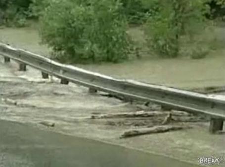
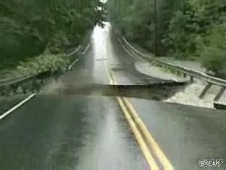
The Power Of Moving Water.
Here is a remarkable video clip - in a span of less than 3 minutes a highway in Australia goes from normal to impassable, as a flash flood eats away at the bottom of the highway.
Regular Fasting May Boost Heart Health. O.K. I was looking for an excuse to fast (save money, take off a few pounds, do something good for your heart). The
latest from the New York Times: "
Regular fasting may be good for your heart. That’s the finding of a new study from doctors in Utah who looked at the relationship between periodic fasting and cardiovascular disease. The researchers interviewed 200 patients who were undergoing a diagnostic test called angiography, an X-ray exam of the blood vessels and heart chambers that can determine if a person has coronary heart disease. The patients were asked if they engaged in regular fasting, and the researchers compared the answers to whether they eventually received a diagnosis of heart disease. Because about 90 percent of the patients were Mormons, a faith that encourages its members to fast for one day a month, the doctors expected to find a relatively high rate of regular fasting among the study participants. The researchers found that people who fasted regularly had a 58 percent lower risk of coronary disease compared with those who said they didn’t fast, according to the report presented at the American College of Cardiology conference in New Orleans this week."
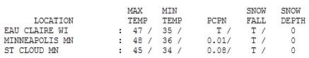
Coolest Day Of The Week. In spite of a chilly, windblown star the mercury still recovered to 45 in St. Cloud, 48 in the Twin Cities - evidence of a higher sun angle. Peak wind gust: 38 mph around noon.
 Paul's SC Times Outlook for St. Cloud and all of central Minnesota:
TODAY: Patchy AM clouds, an isolated spring - then some mild PM sun. Winds: SW 10-20. High: 52
TUESDAY NIGHT: Partly cloudy. Low: 35
WEDNESDAY: Becoming partly sunny, mostly "springy". High: 54
THURSDAY: Clouds increase. Rain possible at night, especially south/east of MSP. Low: 36. High: 53
FRIDAY: More clouds than sun, mild. Odds favor dry weather for the Twins Home Opener. Low: 35. High: 56
SATURDAY: Sunnier, nicer day (again). Low: 38. High: 56
SUNDAY: Cloudy with rain developing. Low: 40. High: near 50
MONDAY: Potentially heavy rain, possibly changing to snow north/west? Low: 35. High: 45
Much Better
"Paul, is it safe to sneak outside and get the mail without clenching both sets of cheeks?" You wouldn't believe the e-mails I get. Nobody is looking forward to spring more than me.
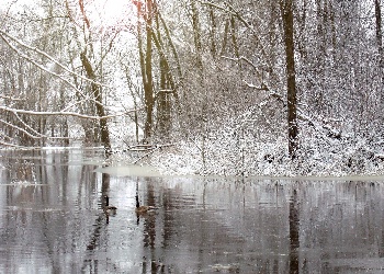
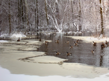
We've passed a milestone: 2 consecutive weeks with no measurable snow in the Twin Cities. Is that the last of the slush? Any other spring I'd offer up a qualified yes. But this is no ordinary winter season. La Nina (Spanish for "get me out of here") is weakening, but still hanging on. This cool stain in the Pacific, along with a stubborn blocking pattern over Canada, is probably (most) responsible for the 5th snowiest winter on record. My hunch/gut feel (nausea?): we'll see 1 or 2 more slushy snows, hopefully minor.
Yesterday's high winds will subside today, morning clouds/sprinkles giving way to 50s and some sun by afternoon. A southern storm brushes southeastern MN with rain late Thursday; skies may brighten for the Twins Home Opener Friday, highs in the mid to upper 50s. Not bad for April 8. We salvage mild sun Saturday, but a more vigorous storm approaching from Kansas may push heavier rain into town Sunday night and Monday. A changeover to heavy wet snow is possible just north/west of MSP on Monday, but right now it looks like all rain for the metro area. A few models are hinting at highs near 60 Saturday, readings may surge well into the 60s Sunday ahead of the storm with a risk of heavy thunderstorms. Just like a light switch: instant spring!
Climate Science: Indicators Of Human Fingerprint On Climate Change. How can we tell that this isn't just another (natural) warming phase? Here's an excerpt from an
article in New York's Press Republican: "
Let's look at one of the indicators in the chart, "Less oxygen in the air." When we combust carbon, from coal, oil or natural gas in order to extract the energy from it, we use two oxygen atoms to convert each carbon atom to carbon dioxide. This is the basic chemistry of that process. This oxygen has to come from someplace and indeed, it does: it comes from the air around us. Careful measurements of the oxygen content of our atmosphere show the levels to be falling in conjunction with the rising amount of carbon dioxide which is exactly what one would expect. Let's look at another indicator, "More fossil fuel carbon (carbon-12) in the air." Carbon atoms come in two primary forms (isotopes). One of these is carbon—14 which is formed in the atmosphere on a natural basis (by cosmic rays) and is radioactive. It has a half-life of about 5,730 years and is formed and decays so that the amount in the air at any one time is normally constant. This is no longer the case.
Stay with me now.
When scientists measure the different isotopes of carbon in the atmosphere today, they find that the relative amount of carbon-14 compared to carbon-12 is decreasing. Since fossil fuels have been buried in the earth for millions of years, all of the carbon-14 isotope has decayed. Thus when these fuels are combusted they release the stable form of carbon (carbon-12) into the air. These emissions dilute the levels of carbon-14 normally present, which tells us that the increased amount of carbon dioxide in the atmosphere is coming from human activities."
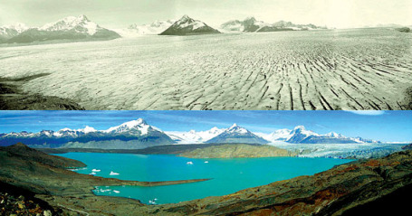
Glaciers Melting Faster Than Originally Thought: Study. An estimated 95% of the world's glaciers are in retreat. A recent
story from physorg.com focusing on South America's Patagonia glaciers, melting much faster than earlier predicted: "
Utilizing a new technique for ice loss calculation, these scientists used the spread of glacier debris and the lines where vegetation starts on the mountainsides to create a series of calculations determining the amount of ice that has melted since the Little Ice Age ended there 350 years ago. Calculations show that the some 270 glaciers that cover the area have lost 606 cubic kilometers of ice. This is the first time that a loss of volume has been calculated to include this far back in time. Recent studies of glacial loss have only gone as far back as to when satellite imaging of the glaciers could be used to calculate loss. While this study does show that the rate this glacial melting and its contribution to the sea level rise is increasing, this was not their most alarming discovery. Research shows that the rate of melting from the beginning of the 20th century was slower than previously thought; their research, however, also shows that since 1980, the rate of glacial loss has increased by over 100 times that of the previous 320 year long-term average. The team points out that the Patagonia glaciers are located at a latitude in the southern hemisphere equal to the Alps in the northern hemisphere, and suggest that if the team were to use the same calculations there, they would see a similar pattern of loss rate increase."
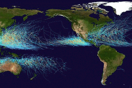
Fewer, More Intense Cyclones (Hurricanes) On The Way: CSIRO. This is still an area of intense debate among meteorologists and climatologists: are warming oceans spinning up more frequent (or intense) hurricanes? There is no (overwhelming) evidence that the number of hurricanes is increasing, but the storms that do form tend to be more intense (number of Category 3-5 hurricanes in the Gulf of Mexico and Caribbean has roughly doubled since 1970, according to NHC). From The Australian:
"The number of tropical cyclones in the Australian region could be halved and waves could become smaller on the nation's east coast, according to CSIRO research commissioned by the federal government that appears to run counter to growing political warnings over extreme weather events.
The surprise results are contained in scientific papers prepared for the Department of Climate Change and obtained under Freedom of Information laws. The Australian published extracts of the findings online yesterday as Climate Change Minister Greg Combet painted a grim picture of the climate change risks at the CSIRO's Greenhouse 2011 conference, held in cyclone-ravaged Cairns. "Clearly, one of the most worrying aspects of climate change is what this could mean for the frequency and intensity of extreme weather events such as droughts, heatwaves, cyclones and floods," Mr Combet told the conference yesterday. "It is these events that impact the most on communities, ecosystems and industry. And, in many instances, the most vulnerable in society will bear the brunt of such impacts."
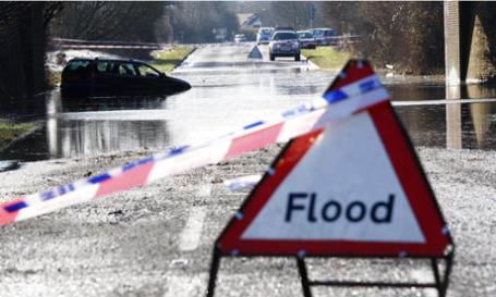
Confronting Health Issues Of Climate Change. A
story from American Medical News: If physicians want evidence of climate change, they may well find it in their own offices. Patients are presenting with illnesses that once happened only in warmer areas. Chronic conditions are becoming aggravated by more frequent and extended heat waves. Allergy and asthma seasons are getting longer. Spates of injuries are resulting from more intense ice storms and snowstorms. Scientific evidence shows that the world's climate is changing and that the results have public health consequences. The American Medical Association is working to ensure that physicians and others in health care understand the rise in climate-related illnesses and injuries so they can prepare and respond to them. The Association also is promoting environmentally responsible practices that would reduce waste and energy consumption. In recent months, the AMA has hosted three state-based CME courses on climate change, most recently in Florida in late February. A fourth is planned later for Illinois. Around the time of the Florida session, the AMA joined with the American Public Health Assn. in a conference call to reporters to bring greater attention to climate change. Florida is an apt setting, because it is particularly sensitive to climate change. Rising air and water temperatures and rising ocean levels since the late 1960s have increased the severity of weather, including hurricanes and droughts, and the production of ground-level ozone." .
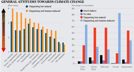
Poor Information And Sense Of Irritation Hamper Climate Change Science. Here's an interesting
article from The Australian:
"A lack of "credible information" is one of the main reasons that 40 per cent of Australians do not believe that humans have a role in global warming, according to the head of the federal government's Climate Commission, Tim Flannery.
And the fact that many Australians found the topic irritating, according to a CSIRO survey, was hampering efforts to communicate the science of climate change and to implement effective policy, he said. "No enduring reforms will happen in this space until we get the weight of public opinion behind them," Professor Flannery told
The Australian. "Climate scientists need to be more widely heard in the public debate. He was commenting on the results of the most comprehensive study yet of Australians' attitudes to climate change. The survey was initiated and funded internally by CSIRO as part of the research program of the agency's Climate Adaptation Flagship, which is charged with helping Australia adjust to a greenhouse world.


No comments:
Post a Comment