49 F. average high for April 5.
November 10: last time the mercury saw 60s in St. Cloud (63 F. on November 10, 2010)
60-degree warmth possible as early as Thursday, better chance of 60s over the weekend.
56 degrees under a mostly cloudy, damp sky for the Twins Home Opener vs. the A's Friday afternoon. The sun may peek through - no steady/heavy rain expected right now, but a light shower or passing sprinkle can't be ruled out.
70s possible Saturday and Sunday over southern Minnesota, 1 in 3 chance of 80-degree warmth reaching southern Minnesota by Sunday.
Severe Threat: heavy to potentially severe storms can't be ruled out along a vigorous warm frontal boundary draped over southern and central Minnesota this weekend. With dew points topping 60, a strong south/southeast surface wind at 15-25 mph, and veering winds with altitude, coupled with significant instability (capes over 2,000, a predicted lifted index as low as -4 to -6) the risk of severe storms will be present, especially late afternoon/evening hours Saturday & Sunday.

A Tardy Spring. Time to lose the parka and the boots. Brush the cobwebs off the bike, dig out the tennis shoes. If you don't have spring fever yet - you will within 48 hours. From the local National Weather Service Office in Chanhassen:
"LOOKS HIGHLY LIKELY THAT THE TWIN CITIES WILL SEE THEIR FIRST 60
DEGREE HIGH OF THE YEAR THIS WEEKEND...WHICH IS THE LATEST A HIGH
OF 60 OR GREATER HAS OCCURRED SINCE 2002...WHEN MSP WAITED UNTIL
APRIL 12TH TO MEET OR EXCEED 60."
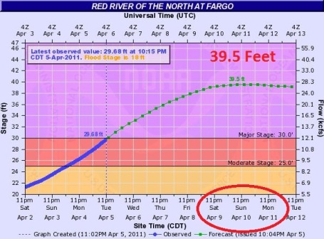
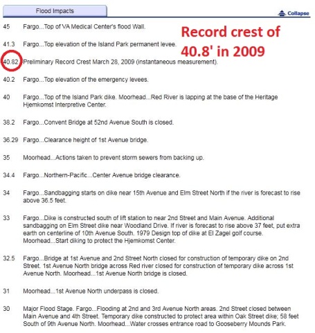
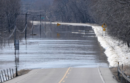
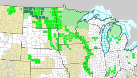
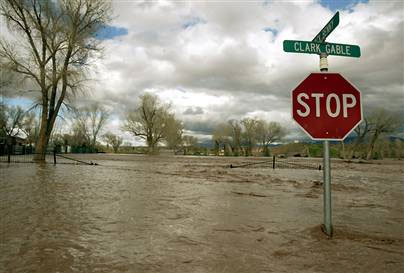
Potential For Record Flooding In Fargo. NOAA hydrologists (river forecasters) are predicting a crest of 39.5 feet on the Red River the weekend. That would be about a foot less than the all-time record crest of 40.8' set on March 28, 2009. It's going to be a very close call for residents of Fargo/Moorhead. More details from NOAA here. A crest of 39.5' would still cause considerable flooding - some perspective below:
.
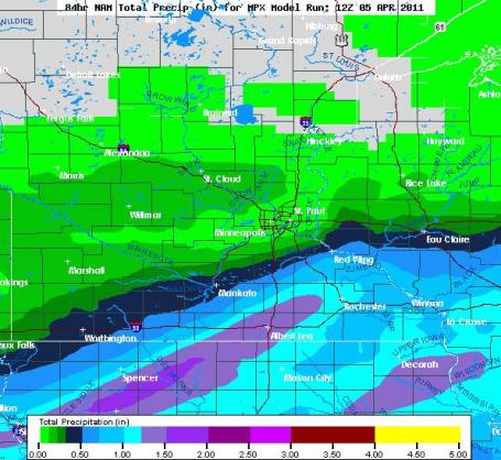
BY THE END OF THE WEEK...ANY REMAINING SNOW COVER ACROSS THE MPX
CWA SHOULD BE ALL BUT GONE. FOR PRECIP CHANCES...STILL LOOKS LIKE
MAIN BATCH OF PRECIP THURSDAY NIGHT WILL STAY SE OF THE AREA...BUT
THERE IS THE POTENTIAL TO SEE UP TO A QUARTER OF AN INCH OF RAIN
ALONG AND SE OF A LINE FROM FAIRMONT...TO RED WING...TO CHIPPEWA
FALLS. OF MORE CONCERN IS THE LARGE STORM SYSTEM FOR THE WEEKEND.
PROBABILITY FOR SEEING MORE THAN AN INCH OF QPF IN 24 HOURS AT MSP
IS AT 60 PERCENT SUNDAY ON THE GFS ENSEMBLE. WITH CONVECTION
EXPECTED...THE THREAT WILL EXIST TO SEE HEAVY RAINFALL AMOUNTS
WITH THIS SYSTEM. WITH AMOUNTS OVER 1.5 INCHES NOT OUT OF THE
QUESTION. THIS WILL NEED TO MONITORED CLOSELY AS THE CROW...
MISS...AND ST. CROIX RIVERS WILL BE NEAR THEIR PEAKS THEN.
Accelerating Run-Off. From the NWS office in Duluth:
HYDROLOGIC OUTLOOK
NATIONAL WEATHER SERVICE DULUTH MN
1252 PM CDT TUE APR 5 2011

...SPRING RUNOFF UNDERWAY ACROSS THE NORTHLAND...

RECENT PRECIPITATION...ONGOING SNOW MELT AND SATURATED SOILS HAVE
COMBINED TO INITIATE OUR SPRING RUNOFF SEASON. WATER PREVIOUSLY
LOCKED IN THE SNOW PACK IS NOW BEING RELEASED AND SNOW COVER IS
DIMINISHING FROM SOUTH TO NORTH. THE FREEZE THAW CYCLE HAS SLOWED
THE RUNOFF MOMENTUM...HOWEVER...WITH WARMER TEMPERATURES EXPECTED
INCREASED MELT RATES WILL GENERATE MORE AREAS OF PONDING WATER AND
RISING STREAMFLOWS. SOILS ARE SATURATED AND...IN MANY AREAS...
WATER IN THE SOIL SITS ATOP A LAYER OF FROST. THERE IS AN INCREASED
RISK OF FLOODING OF LOW LYING AREAS...STREAMS AND RIVERS DURING THE
NEXT TWO WEEKS.

WARMER WEATHER CONDITIONS DURING THE COMING WEEK WILL INCREASE MELT
RATES. EXPECT HIGH TEMPERATURES CLIMBING INTO THE 50S THIS WEEK
WITH OVERNIGHT LOWS REMAINING ABOVE FREEZING.  THIS WILL RESULT IN
CONTINUOUS MELT THUS INCREASING RUNOFF.  IN ADDITION...WEATHER MODELS
INDICATE THE POTENTIAL FOR RAIN THIS WEEKEND AND POSSIBLE
THUNDERSTORMS. AREAS RECEIVING HEAVY RAIN WILL MOST LIKELY SEE RAPID
RUNOFF IN RESPONSE AS SOILS ARE SATURATED AND CANNOT HOLD ADDITIONAL
WATER. MODERATE TO STRONG RIVER RISES WOULD RESULT PUSHING RIVERS
AND STREAMS TO BANKFULL OR FLOOD STAGES.

DURING THIS RUNOFF SEASON STAY UP TO DATE BY CHECKING THE LATEST
WEATHER AND RIVER INFORMATION ON THE INTERNET AT WWW.WEATHER.GOV/DLH
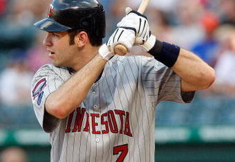
Home Opener Update. Did you know that the odds of a home run increase when the humidity is high? It's true: higher humidity levels mean lower air density, a well-hit ball will carry farther. Go Joe Mauer! And yes, there's a good chance we'll wake up to some rain Friday morning, but the warm front is forecast to lift northward, skies should brighten during the afternoon. I can't rule out a brief/light shower for the game, but odds favor that most of the game will be dry with temperatures in the mid, possibly upper 50s. Damp, but considering what COULD have happened on April 8? Not bad.
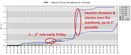
Holding Our (Collective) Breath. With any luck we'll get through the weekend without an inch or more of rain. Thursday night the heaviest rain bands should set up south/east of MSP, but a warm front may stall over southern or central Minnesota over the weekend, acting as a focal point for scattered showers and T-storms; a few may produce locally heavy rainfall amounts of .5 to 1.5" rain. It's impossible to predict (this far out) where the heaviest storms will form, whether we'll have a "train-echo effect", with storms tracking and redeveloping over the same counties. If you live in a flood-prone area you'll want to stay alert, and tune into local media for possible warnings and evacuation orders.
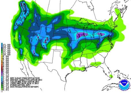
QPF. The latest quantitative precipitation forecast (jibberish for rainfall prediction) shows the heaviest amounts of rain, a 1-2" bullseye, setting up from eastern Iowa to Madison and the Chicago area. I'm not convinced. A more westward storm track could bring the heaviest rainfall amounts from northern Iowa into southern Minnesota over the weekend. Keep in mind the ground is a). still frozen, and b). saturated from a very wet fall. Any rain that does fall won't be able to soak into the soil, but run off almost immediately into streets, storm sewers and (eventually) wind up in Minnesota's rivers. Any heavy rain will also melt the remaining snow on the ground up north, water will which drain into the headwaters of the Mississippi River. This is why meteorologists are so nervous right now. The (sudden) warmth would be bad enough. Throw in significant rain and the odds of a (serious) second crest on area rivers just went up - significantly.
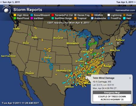
Largest Single-Day Severe Storm Outbreaks. The list below shows the dates with the most severe weather reports, going back to 2006. Data courtesy of SPC.
2010 Top Reporting Day:| 1 | 403 |
2009 Top Reporting Day:
| 1 | 484 |
2008 Top Reporting Day:
| 1 | 714 |
2007 Top Reporting Day:
| 1 | 746 |
2006 Top Reporting Days:
| 1 | 1012 | |
| 2 | 989 | |
| 3 | 773 | |
| 4 | 643 |
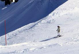
Summer Skiing? Head West. Skiing on the 4th of July? Some resorts near Lake Tahoe have seen so much snow (55-63 feet) that they'll stay open through Memorial Day - a few may open up for skiing on the 4th of July, according to an article at weather.com: "Starting in Squaw Valley USA, just to the northwest of Lake Tahoe in California, snowfall has reached a record high for a season. The old record of 55 feet in 1994-95 has already been broken, and there’s a good chance the area will build on the 57 feet it has already received. The resort has said that they intend to remain open under their daily schedule through May 8, and should have enough snow to open every weekend after that until Memorial Day. And for a resort that normally shuts down in April, this will be a beautiful sight for skiers in the area: they are planning on a July 4 opening for one last big extended weekend. A little farther south at Mammoth Mountain Ski Area, March snow has come in bunches. They recorded 17 feet of snow in March, a record for the month. This will likely allow the resort to open for Independence Day as well."


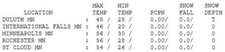
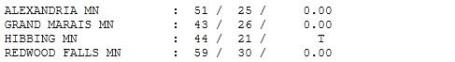
Temperature Inflation. Under a blue sky much of the day temperatures climbed into the 40s up north, low to mid 50s over much of central and southern Minnesota. Highs ranged from 44 at Hibbing to 54 in St. Cloud, 56 in the Twin Cities. BTW, the average high in St. Cloud is now 49 degrees.

Paul's SC Times Outlook for St. Cloud and all of central Minnesota:
TODAY: Early sprinkle, then partly sunny and pleasant. Winds: W 10-20. High: 55
WEDNESDAY NIGHT: Partly cloudy and quiet. Low: 33
THURSDAY: Fading sun, rain possible Thursday night, heaviest south/east of the metro area. High: 55
FRIDAY: Damp start. Showers taper, turning milder - dry much of the afternoon. Low: 35. High: 56
SATURDAY: Mild & muggy, more like early May. Heavy showers and T-storms possible. Low: 47. High: 61 (70+ temperatures possible over far southern MN).
SUNDAY: Showers and T-storms, some strong to potentially severe. Low: 51. High: 66 (70s in the Twin Cities - 80 possible over far southern Minnesota).
MONDAY: Windy with lingering rain showers. Winds may gust to 40 mph. Low: 41. High: 48 (falling during the day).
TUESDAY: Sunshine returns, less wind. Low: 38. High: 55
Weather-Wise
"Living is strife and torment, disappointment and love and sacrifice, golden sunsets and black storms. I said that some time ago and today I do not think I would add one word," said Sir Laurence Olivier. The older I get the more respect I have for nature. In spite of all our technology and scientific breakthroughs we still can't stop a storm (and never will). We rightfully complain about our winters; I still can't fathom how the pioneers survived without central heat, insulation and a thousand other innovations we tend to take for granted.
Spring fever runs rampant this week as winds blow from the south. If the sun comes out for a few hours Saturday & Sunday 70 is not out of the question.
Rain will brush the metro area Thursday night, most showers lifting north in time for the Twins Home Opener at Target Field Friday afternoon. Take a (light) waterproof jacket and be pleasantly surprised if the sky doesn't leak on your head.
A much more potent storm surges north over the weekend, an inch or more of showers & T-storms this weekend. A severe storm outbreak can't be ruled out. By Sunday little snow will be left up north; a second flood crest is probably unavoidable.
* I'm increasingly concerned about an inevitable second flood crest on Minnesota's rivers. The threat will peak this weekend on the Red River in Fargo, but another crest is likely on the Minnesota and Mississippi Rivers in the coming week or two, the result of 60s and 70s this weekend, coupled with a potential for heavy thunderstorms and rapid run-off. If you live in a flood-prone area I can't stress enough that you'll want to stay alert and be ready to move if authorities issue warnings. We're still not out of the woods, and won't be until early May.


* More details on the extinction story from the scientist who wrote the artilce is available at discover.com.


Uh Oh. New Gallup Poll Says Americans Don't Care About Global Warming. By the time a significant percentage of Americans care about changes in the climate, it may be too late to do much about it - that's the paradox. Here's the rather grim news from tinygreenbubble.com: "Actually, in truth that is not what that Gallup poll says. What it does say, however, is that of nine environmental concerns that individuals were polled on, global warming is the least of anybody’s concerns, with only 25% of those surveyed saying that they cared a great deal about global warming and a whopping 48% saying that they cared only a little or not at all. That’s not great news since climate change and global warming are set to cause massive changes in the planet and lifestyle if not held in check.
So what were people concerned with? Perhaps largely led by recent water scares due to both the increased attention to fracking and the Japan nuclear disaster, water and soil issues led the list. The most cared about environmental issue was pollution of drinking water, with 51% caring a great deal. Following that were contamination of soil and water by toxic waste (48%), pollution of rivers, lakes and reservoirs (46%), maintenance of the nation’s supply of fresh water for household needs (46%) and finally air pollution (36%)."
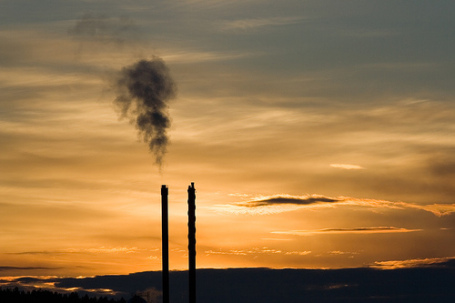
Fortune Panel: Bleak Prospects For U.S. Climate Regulation. Political gridlock, and a reluctance to confront the science, is leading to back-peddling in Congress, according to an article at sustainablebusinessforum.com: "What a different just a few years can make. Hard as it is to believe, there was a time not long ago when Congress appeared to be on the verge of a bipartisan agreement to regulate global warming pollution. Republicans John McCain, John Warner, Newt Gingrich and Tim Pawlenty all supported efforts to put a cap on greenhouse gas emissions. Gingrich and Pawlenty went so far as to appear in commercials with the Environmental Defense Fund supporting climate regulation. And now? “It was a mistake, it was stupid, it was wrong,” Pawlenty says.The radical shift in the political climate means that big NGOs like the Environmental Defense Fund, the Natural Resources Defense Council and the Sierra Club now must fight merely to preserve the status quo in Congress. Environmental groups are playing defense rather than offense in Washington, said Fred Krupp, the president of the Environmental Defense Fund, during a panel today on climate policy that opened FORTUNE’s Brainstorm Green conference. He noted that House Republicans have voted to block funding not just for EPA’s efforts regulate carbon pollution (efforts that are required by a Supreme Court decision) but also for EPA efforts to control, on public health ground, mercury pollution from cement factories. On climate issues, Fred said: “It’s hard to have a meaningful exchange of viewers, a serious conversation in Washington.”
No comments:
Post a Comment