300 fatalities possible from Wednesday's outbreak. As of late Thursday night the death toll was approaching 300.
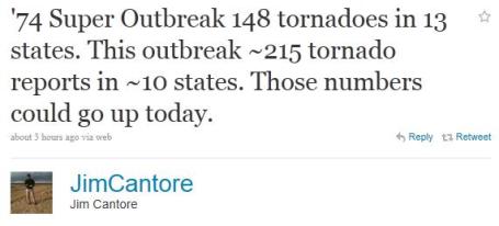
315-330 deaths from the April 3-4, 1974 "Super Outbreak", which spawned 148 tornadoes in 13 states.
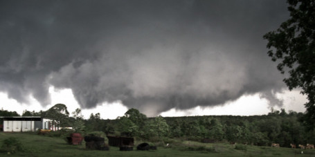
200 miles: Tornado that hit Tuscaloosa may have been on the ground (continuously) for 200 miles.
219 miles: all-time record for a continuous tornado on the ground ("Tri-State tornado of 1925, that left 600+ dead).
60% probability of an "above average number of tornadoes" in Minnesota/Wisconsin in 2011 (see below).
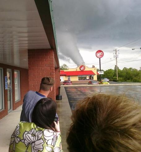
Overhead on local/Alabama media over the last 36 hours:
"If you do not have a basement or underground shelter to go to - you may not survive this tornado." (Tuscaloosa)
"Buildings are missing in Tuscaloosa."
"Tuscaloosa and portions of Birmingham have been turned into a war zone."

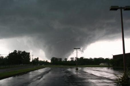
Weather Monster. Steve Miller has some amazing photos of Wednesday's tornado outbreak in Alabama on his web site. Credit for photo above: "Tornado as seen from fourth floor of kings inn - Birmingham, AL."
Grady Dixon, researcher at Mississippi State University (as heard on CNN):
"Wednesday tornadoes were on the ground longer, impacting more people."
"Due to increasingly sophisticated technology and awareness there is a perceived increase in tornadoes, especially the small, brief EF-0 and EF-1 tornadoes."
"The numbers aren't scary, but the intensity is."
"This is not completely surprising - La Nina spring are often severe: 1974, 1999, 2008 were all La Nina springs with more tornadoes than average."
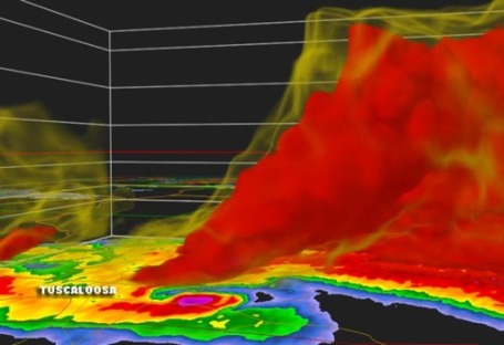
Alabama Tornado Could Rival The Tri-State Tornado. An update from the Southeast Missourian: "The infamous Tri-State Tornado of 1925 holds the record for the longest track by a single tornado, spanning at least 219 miles across Southeast Missouri, Southern Illinois, and into Southern Indiana. That record might be in jeopardy, however, as yesterday's tornado outbreak across the South may have produced a similar long-lived tornado. Preliminary reports suggest that the twister that decimated Tuscaloosa may have stayed on the ground for over 200 miles from Mississippi through Alabama and Georgia before ending in Tennessee. If this tornado did stay on the ground continuously for that long, it could approach, or surpass, the record held by the Tri-State Tornado. The death toll from the 1925 twister was over 600 (not counting deaths from other tornadoes during the same day). Hopefully that number won't be surpassed by yesterday's disaster, although the reports from Alabama and elsewhere are not looking good. This is clearly a once-in-a-generation kind of disaster. If there's a silver lining (and it's tiny), meteorologists now have lots of radar and video imagery of the storms which may help them understand these worst-case outbreaks a little better. The Tri-State Tornado has long been a puzzle for meteorologists trying to figure out how a single tornadic storm can hold together for so long across varied terrain. Future research into the Tuscaloosa tornado may shed some light on how these freak storms are created."
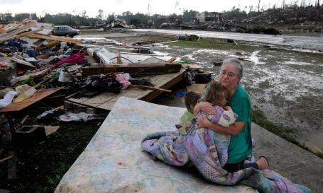
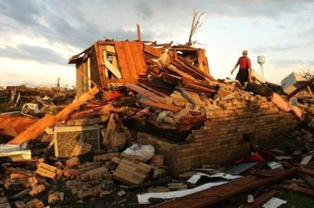
Clinging To Life. From boston.com: "Faye Hyde sits on a mattress in what was her yard as she comforts her granddaughter Sierra Goldsmith, 2, in Concord, Ala. April 27. Their home was destroyed. A wave of tornado-spawning storms strafed the South on Wednesday, splintering buildings across hard-hit Alabama and killing nearly 200 people in four states. At least 58 people died in Alabama alone. (Jeff Roberts/The Birmingham News/AP)"
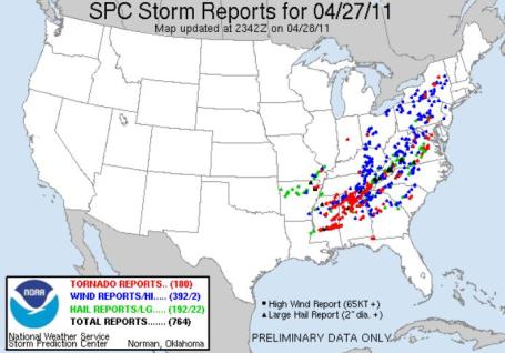
Mind-Boggling Numbers. A preliminary tornado count of 180 on Wednesday, 764 total storm reports. It's a long list of severe storm details from SPC.
April Storm Numbers (SPC):
Total storm reports: 7,307
Tornadoes: 820
Hail: 2,913
Wind: 3,574
Wednesday (April 27)
Total storm reports: 709
Tornadoes: 165
Hail: 184
Wind: 360
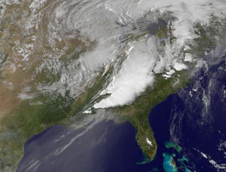
Wednesday Tornado Outbreak From Space. Satellite image of last night's storm at 8:15pm EDT April 27, 2011. Image credit: NASA/GSFC and Jeff Master's Wunderblog.
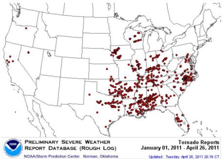
What Does The Current Pattern Mean For Minnesota? More than 600 preliminary tornado reports so far in April, nationwide, a staggering number. Here's some insight from the local National Weather Service: "Tornadoes are spawned from individual thunderstorms, which last on the scale of minutes to hours.These thunderstorms are driven by low pressure systems and associated fronts which occur on the scale of days. So making a direct connection to the recent tornadic episodes and the upcoming thunderstorm season in Minnesota and April is not truly possible. However, as mentioned above, larger scale persistent patterns responsible for the current severe weather are often based on global scale patterns. Such patterns last on the scale of months and thus do offer an opportunity to compare past years with similar patterns. Here are some quick correlations made from 1950-2010:
- A year that has had an April with a top ten number of tornadoes in the country has led to an above normal number of tornadoes in MN and WI six of those ten years.
- Years that have had a La Niña (cooler than normal eastern Pacific waters) of similar strength and in a similar trend of gradually waning, have had an equal amount of active and non-active tornado seasons in MN and WI."
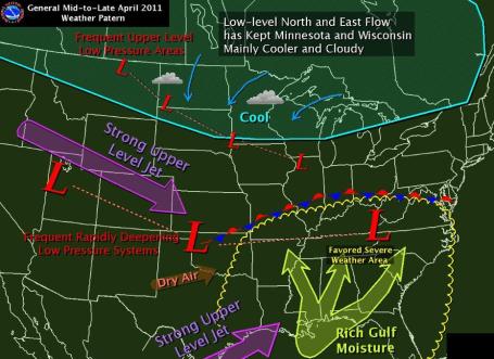
A Southerly Detour Of The Jet Stream. La Nina (cooling of Pacific Ocean water) may be the prime driver in keeping the core of the jet stream, the belt of westerlies, well south of Minnesota. That has kept Minnesota on the cool side, shifting the storm track hundreds of miles to our south for much of spring. Abnormally cool weather over the northern tier states, coupled with seasonal warmth over the Deep South (80s and 90s) has created intense "baroclinicity" over the central and southeastern USA, this sharp temperature contrast whipping up abnormally powerful winds aloft (more typical of early March than late April), which in turn creates a ripe breeding ground for thunderstorms that can tap wind shear (changing wind direction/speed with altitude), spawning the rotating "supercell" thunderstorms that can eventually go on to create large and violent tornadoes. Graphic above courtesy of the local (Chanhassen) National Weather Service.
Why Did So Many People Die? In spite of Doppler radar, more professional storm spotters and the best national weather service in the world, hundreds of people lost their lives in Wednesday's historic tornado outbreak. Even though there was sufficient warning (watches, "high risk" alerts, tornado emergencies, etc) many people were still caught unprepared. There were so many tornadoes, and the tornadoes that did form were so large and violent, passing over heavily populated areas, it was probably inevitable that there would be a large-scale loss of life from this outbreak. As a meteorologist you look at the data and shake your head (with wonder and humility). As a human being you see the videos of leveled neighborhoods, displaced, homeless families, hear their (horror) stories, and you can't help but be heart-broken. Again, the question...why?
* Some tornadoes are not survivable unless you can reach an underground shelter within seconds. The Tuscaloosa tornado was 1 to 1.25 miles wide, probably EF-4 strength with winds close to 200 mph (for 30-60 seconds - it moved fairly quickly). No above-ground shelter will withstand 200 mph winds. The sad reality: many residents of the Deep South do not have basements, and this probably resulted in many of the deaths we saw in Alabama and Mississippi.
* Storm Awareness. People live busy lives, the tornado hit during rush hour when many people were distracted, mobile (or commuting, trapped in their cars). In spite of repeated warnings from the NWS and local media some people may have just not gotten the news with enough time to take evasive action.
* Storm Fatique. The sirens go off quite frequently in Alabama. People may have heard the sirens and thought "it's just another warning - we never see tornadoes, so I'm going to ignore this one too." It would have been a potentially fatal mistake. Some call this the "cry wolf" syndrome. People are overwhelmed with information, many routinely ignore severe warnings. Yesterday that could have turned into a fatal omission.
* Situational Awareness. According to CNN only 40% of Alabama residents have Internet access at home. If you're unable to receive e-mail warnings (and for some reason the TV/radio is turned off), and you can't hear the sirens while indoors - it would have been difficult to get the word in time. What's critical is situational awareness. When a tornado watch is issued, pay much closer attention to 1). the sky, and 2). local media. SPC had issued a PDS, a Particularly Dangerous Situation Tornado Watch. The area was under a "high risk" of tornadoes. Anyone paying attention would have known that this was no ordindary spring day in the south. I've said it before: don't rely on one source of severe storm information. Supplement local media with e-mail alerts on your cell phone. Invest in a NOAA Weather Radio for your bedroom or kitchen. There are scores of apps that can now push severe weather warnings within seconds of when they're issued by the local NWS office.
Mobile Home Dilemma. Many of the storm victims in Alabama lived in mobile homes. As many as 1 in 3 tornado deaths since 1950 were people living in mobile homes, without adequate foundations or any potential to ride out the storm in an underground shelter or basement. I'm hearing whisperings from NSSL (the National Severe Storms Laboratory in Norman, Oklahoma, where much of the breakthroughs in tornado research are taking place) that officials may soon advise residents of mobile homes to leave their homes, get into their vehicles, and try to reach another shelter before the tornado strikes. This isn't official (yet), but data suggests that people may be safer in their vehicles (with air bags and other safety features) than remaining in mobile homes, where they are sitting ducks, especially if a large, violent, long-lived tornado is approaching. This is bound to be controversial, but I wanted you to hear the latest. Frankly (personal opinion) I'm not sure why it's not a state or federal law to require mobile home park operators to make underground shelters available to their residents. That one baffles me to this day.
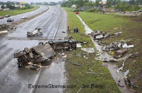
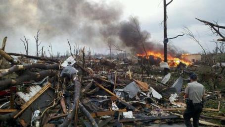
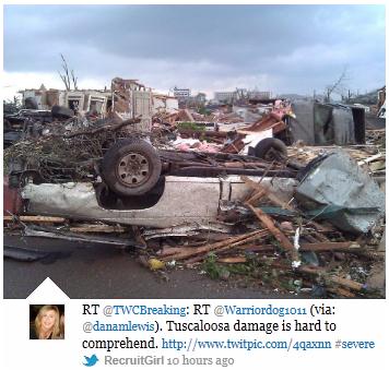
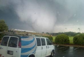
War Zone. This is a photo taken by Jim Edds at extremestorms.com. He writes: "Wrecked cars and UPS truck (driver survived) on I-359 near 31st street overpass."
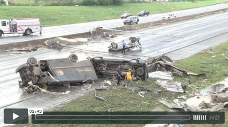
UPS Driver Survives Deadly Tuscaloosa Tornado - Video. Stormvisuals.com has the remarkable story (and video interview) of the UPS driver who got out of his truck and hid underneath a concrete overpass, under the girders. This brings up a real dilemma for meteorologists: research suggests that hiding under a bridge actually increases the risk of being injured or killed by flying debris. And yet if a mile-wide tornado was approaching me, and my choices were: stay with my car, go into a ditch, or seek shelter under a bridge, I would probably do the latter, trying to limit my exposure to flying debris by crawling up into the girders themselves. A lot of bad options here, but when you have seconds to take life-saving evasive action you (ultimately) have to go with your gut. Remember, the risk is not being lifted into the air like Dorothy in the Wizard of Oz. The risk is blunt head trauma: getting hit on the head by a rock or shard of glass traveling at 150-200 mph, a projectile: "Above is footage shot minutes after the major deadly tornado ripped through Tuscaloosa, Alabama on Wednesday afternoon. A driver for UPS named Jimmy Jones, shared his moments as the tornado forced him to abandon his truck and run for safety under the interstate bridge. His truck along with dozens of other vehicles where destroyed by the violent tornadic winds around him. Jim Edds continues to work on more video of this event overnight from the aftermath, and back in Scooba, MS where he first started chasing and filming this long-track tornado. Be sure to also visit extremestorms.com for more information and visuals.
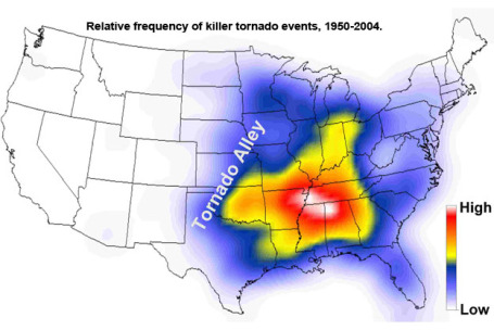
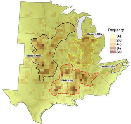
"Dixie Alley". Is "Tornado Alley" shifting east over time? Why do tornadoes in the Deep South cause such a disproportionate number of deaths and injuries? Meteorologists describe 3 unique zones for tornadoes, the traditional "Tornado Alley", stretching from Oklahoma into southeastern Minnesota and southern Wisconsin. A smaller, less violent "Hoosier Alley" extends from Kentucky into southern Michigan, with "Dixie Alley" covering the Lower Mississippi Valley.
The problem/challenge with tornadoes east of the Mississippi:
1). More trees/hills make it harder for storm spotters to track tornadoes on the ground.
2). More population centers in "Dixie Alley" make it inevitable that more populated areas will get hit. Much of Tornado Alley is wide-open space, fields and prairie land. But Dixie Alley is heavily populated - it becomes a statistical probability that a tornado on the ground in Arkansas or Alabama will hit more populated towns than a tornado in Kansas or central Texas.
3). Higher concentration of mobile homes over the Deep South leaves local residents more vulnerable to severe tornadic winds. A significant percentage of the population doesn't have access to basements (too expensive) or other, viable underground shelters. They are quite literally sitting ducks.
4). Fewer basements. This is for a variety of reasons: cost, proximity to groundwater, and rocky soil that makes it cost-prohibitive to excavate.
4). Perception. Most people living in Alabama or Mississippi don't think of themselves as living in a tornado-prone region. Siren coverage is incomplete and tornadoes aren't as front-of-mind as they are for people living on the Plains. And yet research shows a disproportionate number of fatalaties east of the Mississippi, for the reasons listed above.
In Your Vehicle? We're talking about a variety of (very poor) options here. SPC and NSSL now suggest that if you are in your vehicle (and can't reach a shelter in time), it may be safer to stay inside your car or truck than get out of the vehicle and hide in a nearby ditch. Vehicles now have sufficient safety features (seat belts, multiple air bags, shatter-resistant windshields, etc) that, statistically, you may be safer riding out the storm in your car than taking a chance in a nearby ditch.
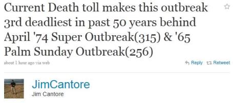
Massive Tornado Outbreak, 100-Year Flood Coming On The Mississippi. Yes, the weather is weird; that's the understatement of the month. Is climate change loading the dice, more warmth, energy and water vapor cooking the books, increasing the probability of extreme events, like tornadoes, floods (and droughts?) Climate scientists believe there is a potential link. Jeff Masters has an comprehensive overview of Wednesday's tornado outbreak and the potential for major flooding on the Mississippi River in his excellent Wunderblog: "A stunning tornado outbreak of incredible violence has left at least 202 dead across the Eastern U.S.; injuries probably number over a thousand, with 600 injured in the town of Tuscaloosa alone. The tornadoes carved huge swaths of damage, completely flattening large sections of many towns, and damage from the storms is likely to be the greatest in history for any tornado outbreak. Hardest hit was Alabama, with at least 149 dead; at least 36 were killed in neighboring Mississippi. NOAA's Storm Prediction Center logged 160 preliminary reports of tornadoes between 8am EDT yesterday and 8am EDT today. At least 11 of these tornadoes were killer tornadoes; deaths occurred in six states. Damage from some of these storms appeared to be at least EF-4, and it is likely that there were multiple violent EF-4 or EF-5 tornadoes. The death toll makes the April 27 - 28 outbreak the third deadliest tornado outbreak of the past 50 years, behind the April 3 - 4, 1974 Super Outbreak (315 killed) and the 1965 Palm Sunday tornado outbreak (256 killed.)"
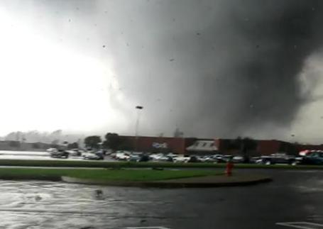
Mile-Wide Tornado, On The Ground For Nearly 2 Hours. How is this possible? The amount of energy required to sustain an EF-4 tornado for that length of time is unimaginable. There was significant warning (from the NWS and local media). The sirens were sounding, and yet 3 to 4 dozen people lost their lives in Tuscaloosa alone. The reality? If a mile-wide swath of 200 mph winds is approaching and you can't get into an underground shelter, the risk of death or severe injury is very high. Even well-constructed homes and other buildings can't withstand winds that strong. Here's a remarkable YouTube video clip: "This video is from the EF4 tornado that went through Tuscaloosa, AL on 4/27/11. It was taken from the University Mall parking lot. Probably the closest video to the storm your going to see."
CNN Live Blog. CNN in Atlanta has a running tally of storm reports and updates on the death toll here:
[Updated at 12:38 p.m. ET] The death toll from severe weather in Alabama has reached 162, Alabama Emergency Management Agency spokeswoman Yasamie August said Thursday. The overall death toll is as many as 247 people in six states.
[Updated at 12:33 p.m. ET] The death toll from severe weather in Georgia is at 14, Gov. Nathan Deal said Thursday. There are now as many as 234 people dead in six states.[Updated at 11:53 a.m. ET] In the DeKalb County, Alabama town of Rainsville, 25 bodies were recovered near one parking lot in the center of town, said Israel Partridge, a local business owner who teaches search and rescue and volunteered to help the Rainsville Fire Department Wednesday night. Rainsville Police Chief Charles Centers confirmed the 25 dead, adding eight were in one trailer park. Many people are unaccounted for, Centers said. Partridge said one tree that had been uprooted and tossed still had a dog alive, tied to it. Partridge said he freed the dog and gave it to a family to take care of.
[Updated at 10:20 a.m. ET] Thirty people have died in Tennessee as a result of severe weather, according to the Tennessee Emergency Operations Center. The death total from a wave of powerful storms that struck the South is now as many as 231 people in six states.
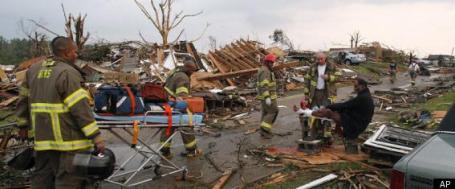
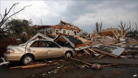
Scores Die In Storms Across South, Tornado Ravages City. The New York Times has the latest on the disaster in Tuscaloosa: "Devastating storms swept through the South on Wednesday, killing at least 60 people and spawning a tornado that tore through downtown Tuscaloosa, Ala. The evening twister flattened homes and buildings and brought further damage and death to a region already battered by storms. Across Alabama, at least 50 people were killed by storms on Wednesday alone, according to officials. The Associated Press reported an additional 11 deaths in Mississippi, two in Georgia and one in Tennessee. The tornado, one of several that struck the state, ripped through Tuscaloosa about 5 p.m. on a northwest path. It veered past a major medical center, a high school and the campus of the University of Alabama. The extent of the damage was unclear Wednesday evening, but officials said many people were still trapped in homes and buildings. They feared the death toll could rise in the coming days. Many parts of the state had been on a tornado watch throughout the day, prompting schools, government offices and businesses to shut their doors early or remain closed, Mayor Walter Maddox of Tuscaloosa said in an interview Wednesday evening."
Aftermath. The images and videos coming out of Alabama (hardest hit) and Mississippi is extraordinary, and heartbreaking. Some of these tornadoes were a mile wide, on the ground for 1-2 hours. Storify has a special updating URL with photos and stories from the Tuscaloosa tornado. Here's an update from NOAA:
PUBLIC INFORMATION STATEMENT
NATIONAL WEATHER SERVICE BIRMINGHAM AL
808 AM CDT THU APR 28 2011

...UPDATED FOR JEFFERSON AND TUSCALOOSA COUNTY SURVEYS...

IN REGARDS TO THE JEFFERSON AND TUSCALOOSA COUNTY DAMAGE...SUBJECT
MATTER EXPERTS FROM AROUND THE COUNTRY WILL BE ARRIVING TODAY TO
ASSIST WITH SURVEYS...AND DAMAGE RATINGS WILL BE PROVIDED AFTER A
THOROUGH ASSESSMENT IS CONDUCTED.

NATIONAL WEATHER SERVICE METEOROLOGISTS TODAY WILL BEGIN THE TASK OF
ASSESSING THE DAMAGE FROM A TRAGICALLY HISTORIC DAY OF TORNADIC
ACTIVITY AND SEVERE WEATHER ACROSS CENTRAL ALABAMA.  THERE WERE TWO
WAVES OF SEVERE WEATHER.  THE FIRST MOVED THROUGH DURING THE EARLY
MORNING HOURS ACROSS NORTHERN PORTIONS OF CENTRAL ALABAMA PRODUCING
DAMAGING STRAIGHT LINE WINDS AND ISOLATED TORNADOES. THE SECOND WAVE
INVOLVED NUMEROUS SUPERCELL THUNDERSTORMS AND PRODUCED LONG LIVED...
STRONG TO VIOLENT TORNADOES ACROSS THE NORTHERN TWO-THIRDS OF
CENTRAL ALABAMA...WITH WIDESPREAD AND CATASTROPHIC DAMAGE IN SEVERAL
LOCATIONS.
Stats On The Deadliest Tornado Outbreak Of My Life. Accu Weather's Jesse Ferrell has some eye-opening statistics about Wednesday's historic outbreak (these numbers will change as new data arrives):
Deaths Yesterday: 231 (149 Alabama)
Deaths This Month: ~282
LSR Tornado Reports: 211
SPC Tornado Reports Yesterday: 164
SPC Tornado Reports This Week: 329 (276 in 3 days; 232 in 2 days)
SPC Tornado Reports This Month: 818
LSR Funnel Cloud Reports Yesterday: 55
"Reports" may contain multiple reports of the same tornado, and is therefore not comparable to previous historical extremes such as the 148 confirmed tornadoes during the Super Outbreak. "Yesterday" is defined as 12Z 4/27 to 12Z 4/28.
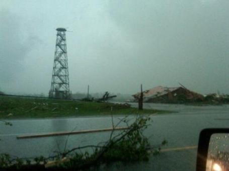
"Let's Check The Doppler - Hold On..." This is every meteorologist's nightmare, as if multiple families of EF-4 tornadoes weren't nightmare enough. When one of those tornadoes rips your Doppler (radome), the rotating antenna that sends out the beam of energy that detects rain, hail and calculates the wind vectors within a severe storm - you are literally flying blind. From Steven Millers's web site: "From KAKE Meteorologist Jay Prater "I was the Managing Meteorologist at WAFF-48 in Huntsville, Alabama when "Doppler 2000" was installed along US-72, in the late 90s. My "pride and joy"...at that time, it was the most advanced privately owned weather radar in the state. Only the tower remains today after being struck by a tornado. Thank you WAFF-48 Chief Meteorologist Brad Travis for posting this image."
A Surreal Sight. Here's the tornado that swept through Arab, Alabama, captured by storm chaser Brett Adair (courtesy of Steve Miller's weather blog).
War Zone. The Washington Post has more images from Wednesday's extraordinary tornado outbreak here.
A Few Thoughts About Wednesday's Tornado Outbreak. "Wednesday was a very long day, covering an (historic) outbreak of tornadoes. It brings back memories (nightmares) of the 1974 Super Outbreak, 148 in one day – an unprecedented event which ultimately got me into the meteorology business. I have no doubt yesterday’s outbreak will spawn more meteorological careers as people try to understand what happened to them. There is no conclusive link between tornado frequency/intensity and climate change. Tornadoes are such localized events, drawing on low-level moisture and wind shear aloft (changing wind direction/speed as you rise up through the atmosphere). Climate change means that surface temperatures, potential instability, and the sheer amount of available water vapor, are all trending upward, potentially providing more fuel for ALL storms. But linking any one event to climate change is problematic, and, in truth, a scientific oversimplification.
A much more significant factor this year has been a weakening La Nina. The same cooling of Pacific water that contributed to record snows across much of America has energized the jet stream, the winds overhead are blowing faster than usual for late April, which sets the stage for “supercell” thunderstorms that can translate horizontal wind shear into vertical shear. Other La Nina springs featured an unusual number of violent tornadoes: 1974, 1999 and 2008. The northern USA has been considerably cooler than usual, while the south has heated up into the 80s and 90s, creating a much more severe north/south temperature contrast – which means the winds overhead have to blow faster (than usual), setting the stage for large and violent tornadoes.
I’m including a link from a 2007 NASA study suggesting that (much like hurricanes) suggests that climate change may impact the intensity of tornadoes, but there is no firm, scientific conclusive link (yet). Nothing can be said with a high level of confidence that will withstand detailed scrutiny – much more research is needed to determine a conclusive link.
It’s human nature to want a smoking gun, a simple explanation to a very complex atmospheric challenge. Climate change may be one of many contributing factors, but La Nina was (probably) a much more significant player in yesterday’s historic outbreak, helping to energize and focus jet stream winds. Tornadoes require a very specific menu of weather ingredients, and yesterday all those factors converged on the Deep South.
In an age of Twitter, YouTube and social media we’re doing a better job of finding tornadoes that might have gone unreported 50 years ago. Much of the increase in tornadoes in recent decades is probably the result of more storm spotters/chasers out in the field looking for them, especially in the wake of the movie “Twister”. The more significant question focused on intensity. Are tornadoes (as well as hurricanes) become more intense over time? There is some evidence that hurricane intensity has gone up since 1970, especially in the Gulf of Mexico. But the jury is still largely out on whether a warmer, wetter atmosphere is breeding more severe tornadoes.
I’ll say this much: if the climate scientists are right (and I tend to believe the 97.4% of peer-reviewed climate scientists who believe the atmosphere is warming, and man is a big contributing factor in that warming) – we’ll probably see a continued escalation in flash flooding, extreme hurricanes, and intense EF-3 or stronger tornadoes over time. Again, it’s impossible to link any one storm, tornado outbreak, winter season or even an entire year to climate change. But gradually, over time, we are inadvertently loading the dice in favor of more extreme weather events. I don’t think this is our imagination. There probably is a link, but much more research is needed before the science can conclusively state that a warming atmosphere creates a riper environment for the kind of deadly, long-lived and violent tornadoes we witnessed yesterday."
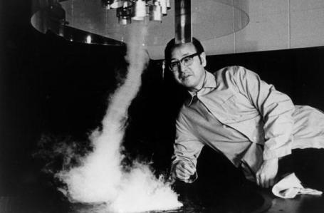
"Mr. Tornado". The F in the EF-scale used to rate the severity of tornadoes is for Ted Fujita, the famous researcher who did groundbreaking work out of the University of Chicago. More on his amazing life and critical breakthroughts in this article from Chicago Magazine: "The news today has been dominated by the tornadoes that devastated the South yesterday; an estimated 250 people were killed, the first time in almost 40 years that more than 100 people have been killed by a tornado outbreak. That was the Super Outbreak of 1974, the most intense tornado outbreak on record, which generated 148 tornadoes from Alabama to Ontario and killed over 300 people. (The most deadly tornado outbreak was the one that generated the Tri-State Tornado, which alone killed 695 people in three and a half hours on March 18, 1925.) In the wake of the Super Outbreak, a University of Chicago scientist named Ted Fujita, known in the meteorology business as "Mr. Tornado," spent ten months studying its aftermath in "the most extensive aerial tornado survey ever conducted." Only a couple years before, Fujita had developed his most famous contribution to the science, the F-scale (since revised, and now called the Enhanced Fujita Scale), which estimates wind speed from wind damage. The Super Outbreak allowed Fujita to apply it on an immense scale—a scale that's never before or since existed. Here's the map that resulted from Fujita's months of research; the density of the tornadoes is incredible. Tom Skilling argues that Fujita's greatest scientific contribution is not the famous Fujita Scale, but his discovery of downbursts and microbursts, falling columns of cold air that can create tornado-like damage, or crash an airplane. It's incredible: like a bucket a couple miles across being dumped out of the sky.
Will A Warmer World Be Stormier? An interesting (and critical) question, in light of Wednesday's deadly tornado outbreak. Here's an article from earthzine.org: "Increases in carbon dioxide and other greenhouse gases have almost certainly played a major role in the observed temperature increases of the 20th Century, according to the Intergovernmental Panel on Climate Change (IPCC) Fourth Assessment Report. Global climate model (GCM) projections suggest that continued 21st Century increases in greenhouse gases will further warm the climate by a few degrees. A temperature change this small may not seem very serious, since local weather can fluctuate by much more than this from day to day. The small global mean change, however, is expected to create large problems in sensitive areas of the Earth system — rising sea level leading to increased coastal flooding, more heat waves and drought, and the disappearance of summer Arctic sea ice, to name a few. Among the most important potential impacts of climate warming are changes in extreme weather events. Global precipitation will increase, and the heaviest precipitation events are intensifying [1], but with regional differences: Wet regions such as the tropical rainforests will become rainier while semi-arid regions of the subtropics expand and become drier. This is only one of the impacts of extreme weather, however. Equally important are the winds, hail, lightning, and fires that result from storms. Will we see more frequent storms in a warmer climate? Stronger storms? Will storm damage escalate? These questions are much harder to answer. Different types of storms — thunderstorms, tornadoes, hurricanes, synoptic midlatitude storms — occur under different conditions, though all storms can be thought of as the atmosphere’s most efficient means of redistributing heat from places with an excess to places with a deficit. Global climate models only explicitly represent the atmosphere on spatial scales of 100-200 kilometers, due to the computational demands of conducting many long simulations of future climate under various emission scenarios. By comparison, most weather is generated by processes that occur over kilometers to tens of kilometers. Thus, changes in weather can only be indirectly inferred in climate models from changes in large-scale environmental conditions."
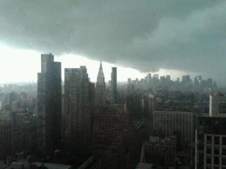
A Threatening Sky. Check out this photo of a squall line passing over New York City, shot from the Empire State Building, courtesy of yfrog.com.
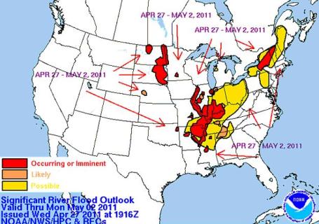
Historic Flood Potential. Meteorologist Kristin Klingelhutz has an update on severe flooding gripping the Mississippi and Ohio River Valleys:
The Ohio River at Cairo, Illinois is expected to crest at 60.5 feet on May 1. This would exceed 100-year flood stage, and be the highest flood in history, besting the 59.5' mark of 1937.
Along a 400-mile stretch of the Mississippi, from Cairo to Natchez, Mississippi the Mississippi River is expected to experience the highest flood heights since records began 100 or more years ago, at 5 of the 10 gauges on the river along this stretch. The records are predicted to begin to fall on May 3 at New Madrid, and progress downstream to Natchez by May 20.
Graphic of where flooding is expected or is occurring in the US
http://www.hpc.ncep.noaa.gov/nationalfloodoutlook/
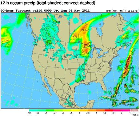
A little more detailed graphic of flooding. Notice the record breaking flood stage at 52' at Smithland Lock and Damn.
Ohio River Valley
http://www.erh.noaa.gov/ohrfc/
North Central
http://www.crh.noaa.gov/ncrfc/
Lower Mississippi
http://www.srh.noaa.gov/lmrfc/
Flash Flood Guidance for Ohio River Valley
http://www.srh.noaa.gov/rfcshare/ffg.php?duration=3&location=OHRFC
Showery Saturday. The models all print out rain for Saturday, best chance of showers (and possible thunder) Saturday morning into the midday hours. Skies may brighten during the afternoon with some sun possible by late afternoon or evening. The later in the day you plan your outdoor activities Saturday, the better the odds you'll be rain-free. Sunday definitely appears to be the nicer day of the weekend statewide.
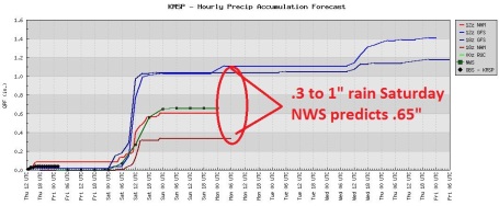
Looks Like A Weekend. The models differ on amounts, but there's little doubt it will rain on Saturday, especially morning hours.
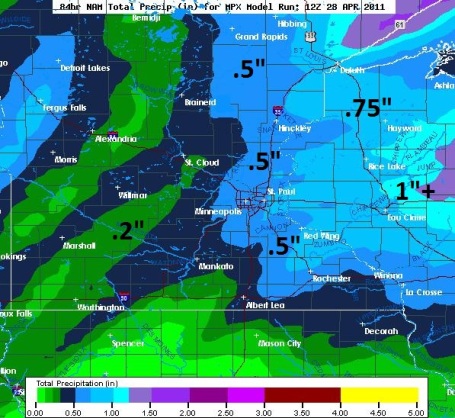
Green Lawns. The latest NAM simulation prints out roughly a half inch of rain (which seems reasonable). The farther east you go, away from MSP, the heavier the predicted rainfall amounts.
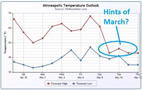
Temperature Roller Coaster Ride. Temperatures trend fairly close to average next week (string of 60-degree plus highs). Next weekend looks mild: 60s, even a chance of 70 the weekend of May 7-8, followed by a rather dramatic cooling trend the second week of May. What a spring...
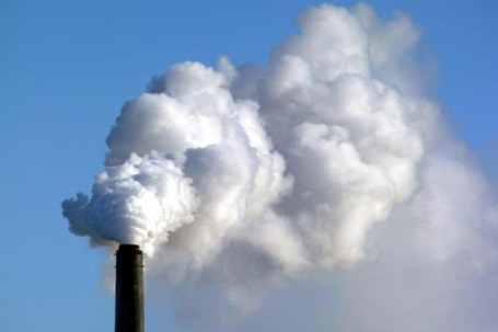
State Of The Air 2011: Air Quality Report Reveals High Pollution Levels In U.S. Cities. Huffington Post has an update on air pollution, specifically ozone, in America's largest cities: "NEW YORK -- The American Lung Association's newest State of the Air report is a bit like getting a 53 on your math test after you got a 49 on your last one. Yes, you've improved, but you’re still failing the class. Though the report, released Wednesday, states that air quality has improved in some places, over 154 million people are still threatened by dangerously high pollution levels nationwide. Some cities, like Los Angeles and Pittsburgh, reduced their overall pollution levels, yet their year-round particle pollution levels are still higher than the national standard, and Los Angeles County is still ranked on all three “25 Most Polluted Counties” lists. In other words, things are improving, but they're still not good enough. The 2011 State of the Air Report, which is based on data from 2007 to 2009, reports on levels of pollution from monitoring sites across the U.S. The report focuses on two specific types of pollution -- ozone and particle pollution -- because according to the ALA, these types are most responsible for the country's air pollution problem. Ozone air pollution is different than the ozone layer found in the stratosphere, which provides a necessary barrier from the sun's harmful ultraviolet rays. Rather, ozone air pollution, which is found at ground level, is harmful to breathe and is the primary ingredient in smog. Contributors to ozone pollution include tailpipe and smokestack emissions."
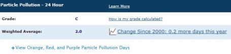
Minneapolis Gets A "C". Based on the 2011 State of the Air Report referenced above, Minneapolis/St. Paul gets a "C" for particle pollution. Click here to see the full report for the MSP metro area.
Facetime: Weather Channel Chief Paints Rosy Company Picture. Here's an excerpt of a recent article in the L.A. Times: "Mike Kelly oversees a cable network in nearly every one of the nation's 100-million cable homes and weather.com, a website with more than 40 million monthly visitors. Annual revenues top $500 million and 'digital offerings are going through the roof. The Weather Channel, which turns 29 on Monday, was initially a hard sell. After all, who would tune in for something they could find out by looking out the window? Conceived by "Good Morning America" meteorologist John Coleman, the idea was rejected by potential partners left and right until Landmark Communications and its then-owner Frank Batten backed him and launched the network. In 2008, Landmark sold the company to private equity firms Bain Capital LLC and Blackstone Group and NBC Universal for $3.5 billion, and the new owners tapped Kelly, who spent most of his career in magazine publishing at Time Inc., to run the company. Looking to change the perception that it is more than only about precipitation, the network has added original programming with shows such as "Storm Stories" and its latest series "From the Edge with Peter Lik," which follows the renown landscape photographer around the country as he battles the elements to find the perfect shot. The network has to be careful not to stray too far from its roots and alienate its core audience, as was the case a few years ago when its decision to telecast weather-themed movies ("The Perfect Storm") backfired."

Technology Advances; Humans Supersize. Here's a fascinating article from the New York Times about just how far we've come (as a species): "This “technophysio evolution,” powered by advances in food production and public health, has so outpaced traditional evolution, the authors argue, that people today stand apart not just from every other species, but from all previous generations of Homo sapiens as well. “I don’t know that there is a bigger story in human history than the improvements in health, which include height, weight, disability and longevity,” said Samuel H. Preston, one of the world’s leading demographers and a sociologist at the University of Pennsylvania. Without the 20th century’s improvements in nutrition, sanitation and medicine, only half of the current American population would be alive today, he said. To take just a few examples, the average adult man in 1850 in America stood about 5 feet 7 inches and weighed about 146 pounds; someone born then was expected to live until about 45. In the 1980s the typical man in his early 30s was about 5 feet 10 inches tall, weighed about 174 pounds and was likely to pass his 75th birthday."

Jobs Says Apple Made Mistakes With iPhone Data. Apple's top guy tries to get out ahead of a PR mess, as reported in the New York Times: "SAN FRANCISCO — Hoping to put to rest a growing controversy over privacy, Steven P. Jobs, Apple’s chief executive, took the unusual step of personally explaining that while Apple had made mistakes in how it handled location data on its mobile devices, it had not used the iPhone and iPad to keep tabs on the whereabouts of its customers. “We haven’t been tracking anybody,” Mr. Jobs said in an interview on Wednesday. “Never have. Never will.” Mr. Jobs said that Apple would fix the mistakes in a free software update that it would release in the next few weeks. Mr. Jobs, who is currently on medical leave, addressed the issue along with two Apple executives — Philip W. Schiller, the senior vice president of worldwide product marketing, and Scott Forstall, the senior vice president of iPhone software. A week ago, two researchers reported that they had discovered a file in Apple’s devices containing what appeared to be data of the locations visited by users over the previous 12 months. The discovery raised fears that Apple was tracking its users and prompted investigations by various European governments and demands for explanations from United States lawmakers."
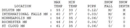

Getting Better (In A Hurry). After a gray, windy start the sun finally made a cameo appearance Thursday afternoon, tugging the mercury to 56 in the Twin Cities. Where the sun was out longer the mercury climbed higher: 61 at St. Cloud and Redwood Falls, 62 up at Grand Marais.
Paul's SC Times Outlook for St. Cloud and all of central Minnesota:
TODAY: Plenty of sunshine, pleasantly mild. High clouds arrive by afternoon. Winds: SE 10-20. High: 66
FRIDAY NIGHT: Cloudy, chance of showers, possible thunder late. Low: 49
SATURDAY: Showers taper in the morning, turning breezy and cooler with peeks of sun possible by late afternoon. Winds: NW 15-25. High: 56
SUNDAY: Nicer day of the weekend. Plenty of sunshine, still on the cool side, but much better. Low: 38. High: 55
MONDAY: More clouds than sun, cool. Low: 34. High: 56
TUESDAY: Plenty of sun, warming up again. Low: 41. High: 68
WEDNESDAY: Unsettled, few showers, possible thunder. Low: 48. High: 63
THURSDAY: Cool, damp. Light showers linger. Low: 42. High: 56
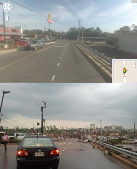
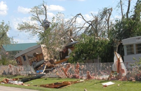
A Grim Before And After Sequence. Steve Miller has some extraordinary photos of the tornado aftermath on his weather blog, including this before/after photo of Tuscaloosa. The area is almost unrecognizable after the EF-4 tornado.
Lessons Learned
"If you don't have a basement you may not be able to survive this tornado." The warnings that went out late Wednesday in Alabama were dire. In spite of Doppler radar, 20-45 minutes warning, local media providing continuous coverage - hundreds died. How could this happen? Nothing can withstand a mile-wide, EF-4 tornado with 200 mph winds. Basements are rare, due to bedrock & high water tables. Since 1950 1 in 3 tornado-deaths have been people living in mobile homes, especially vulnerable to tornado winds. WeatherNation PhD researcher Patrick Francis, warns "the laws of fluid dynamics states that people would be safer sitting in their car, outside of the trailer, than IN the trailer." I've heard whispers (not confirmed yet) that government officials may soon tell residents of mobile homes to get into their vehicles and try to outrun a tornado. Controversial? You bet, but all options are poor when a mile-wide landfill swirling at 200 mph is moving in your direction.
Sunny 60s return today. Soak it up; .50+" rain may fall Saturday (but nothing severe is expected). Some sun returns Sunday, more 60s next week. Odds may favor an unusually severe 2011 for Minnesota; more on my blog.
"Loading The Dice" - A Cost Of Denying Climate Change: Accelerating Climate Disruptions, Death and Destruction. Climate scientist Peter Gleick attempts to answer the question I heard a lot on Thursday. "Is there a link between all these extreme weather events and climate change?" "Is this just normal weather?" "Is this the NEW normal?" All great questions; here's his article in Huffington Post. "Violent tornadoes throughout the southeastern U.S. must be a front-page reminder that no matter how successful climate deniers are in confusing the public or delaying action on climate change in Congress or globally, the science is clear: Our climate is worsening. More extreme and violent climate is a direct consequence of human-caused climate change. There is a reason it isn't called global warming anymore. Higher temperatures are only one -- and not the most worrisome -- of the consequences of a changing climate. Climate science tells us unambiguously that we are changing the climate and trapping more energy on the planet. Trapping more energy will cause more extreme events and worsen extreme events that would otherwise happen. In the climate community, we call this "loading the dice." Rolling loaded dice weighted toward more extreme and energetic weather means more death and destruction. And it is only going to get worse and worse, faster and faster, the longer our politicians dither and delay and deny. Climate deniers who have stymied action in Congress and confused the public -- like the tobacco industry did before them -- need to be held accountable for their systematic misrepresentation of the science, their misuse and falsification of data, and their trickery.
NASA Study Predicts More Severe Storms With Global Warming. Scientists have been warning of a possible link for many years now. Was Katrina a smoking gun? Will we ever be able to prove, scientifically, that Wednesday's extreme tornado outbreak was triggered by climate change? Probably not. But as the atmosphere trends warmer and wetter over time we can expect more "global weirding", more weather events that leave us scratching our heads, trying to connect the dots. Here's a 1997 NASA study: "Previous climate model studies have shown that heavy rainstorms will be more common in a warmer climate, but few global models have attempted to simulate the strength of updrafts in these storms. The model developed at NASA’s Goddard Institute for Space Studies by researchers Tony Del Genio, Mao-Sung Yao, and Jeff Jonas is the first to successfully simulate the observed difference in strength between land and ocean storms and is the first to estimate how the strength will change in a warming climate, including “severe thunderstorms” that also occur with significant wind shear and produce damaging winds at the ground. This information can be derived from the temperatures and humidities predicted by a climate computer model, according to the new study published on August 17 in the American Geophysical Union’s Geophysical Research Letters. It predicts that in a warmer climate, stronger and more severe storms can be expected, but with fewer storms overall." (photo above courtesy of Weather Underground).
Outlook Dim For Climate Agreement By Year's End. The New York Times has the story: "BRUSSELS — Major greenhouse gas-emitting nations on Wednesday ruled out reaching a global agreement to limit such gases at a meeting this year in Durban, South Africa, but they pledged to continue working toward that goal in future. “I don’t think anyone thinks there’s going to be an actual, completed legally binding agreement in Durban,” Todd Stern, the U.S. special envoy for climate change, said at a news conference after a two-day meeting of the so-called Major Economies Forum on Energy and Climate in Brussels. The forum holds discussions on climate issues in parallel to formal negotiations under the auspices of the United Nations. Rather than aiming for an accord in Durban, negotiators participating in the forum, which includes the European Union, Japan, China, India and Brazil, discussed working on “decisions or language that would look toward negotiation of a legally binding agreement in the coming year” in South Africa, Mr. Stern said. Even so, he said there was no certainty that such a deal would eventually be reached."

The Truth Is Out There. Here's a timely editorial from the Stephan Lewandowsky at the ABC Network in Australia. When it comes to climate change, science isn't enough. No, we have to delve into psychology and the way people process and internalize information (they find threatening): "What motivates people to reject trivially simple facts - such as the President's place of birth - as well as more complex facts - such as insights from geophysics and atmospheric science? The peer-reviewed psychological literature provides some insight into this question. Numerous studies converge onto the conclusion that there is a strong correlation between a person's endorsement of unregulated free markets as the solution to society's needs on the one hand, and rejection of climate science on the other. The more "fundamentalist" a person is disposed towards the free market, the more likely they are to be in denial of global warming. But what do markets have to do with geophysics or the thermal properties of CO2? The answer is that global warming poses a potential threat to laissez-faire business. If emissions must be cut, then markets must be regulated or at least “nudged” towards alternative sources of energy—and any possibility of regulation is considered a threat to the very essence of their worldview by those for whom the free market is humanity's crowning achievement. It is this deep psychological threat that in part explains the hyper-emotionality of the anti-science discourse: the frenetic alarmism about a "world government", the rhetoric of "warmist" or "extremist" levelled at scientists who rely on the peer reviewed literature, the ready invocation of the spectre of "socialism"—they all point to the perception of threat so fundamental that even crazed beliefs can constitute an alluring antidote. Paradoxically, there is actually good reason to think of socialism in the context of the denial of climate science. It has been a long-standing source of puzzlement among outside observers how the Soviet Union and its satellites could bumble along for so long without reforming their sclerotic economies. Didn’t they notice that the shelves were empty? That Western workers enjoyed a far more comfortable life-style than their Soviet brethren? No, the Soviet ideologues didn't notice and they wouldn't have seen anything even if someone had forced them to look."
"Because ideology trumps facts."
(Stephan Lewandowsky is a Winthrop Professor and Australian Professorial Fellow at the University of Western Australia. His research addresses the distinction between skepticism, cynicism, and denial. Find him and his colleagues here.)

Acceptance Of Science And Ideology. Lewandowsky wrote another article tackling the subject of ideology and world-view, and how this impacts the ultimate acceptance or denial of climate science, this time for shapingtomorrowsworld.org: "The answer is that global warming, like many other environmental problems, poses a potential threat to laissez-faire business. If emissions must be cut, then markets must be regulated or at least “nudged” towards alternative sources of energy—and any possibility of regulation is considered a threat to the very essence of their worldview by those for whom the free market is sacrosanct. (As an aside, this fear of regulation can actually be counter-productive; there is evidence that regulation can have beneficial effects to the industry being regulated; Farzin, 2003. So rational self-interest is insufficient to explain the fear of regulation)."
No comments:
Post a Comment