62 F. average high for April 29.
51 mph wind gust at Hanley Falls (Yellow Medicine County) at 4:35 pm Friday (MnDOT weather station).
.66" rain predicted for St. Cloud morning/midday hours today (NAM model).
35 mph wind gusts possible in the metro area Sunday.
47 F. high predicted for tomorrow, May 1. Last year the high on May 1, 2010 was 64 F.
Blizzard Warning: posted for central/western North Dakota into Saturay evening for 3-9" snow and 55 mph. gusts.
2.5 earthquake on the Richter Scale near Fergus Falls reported at 2:20 am Friday morning.
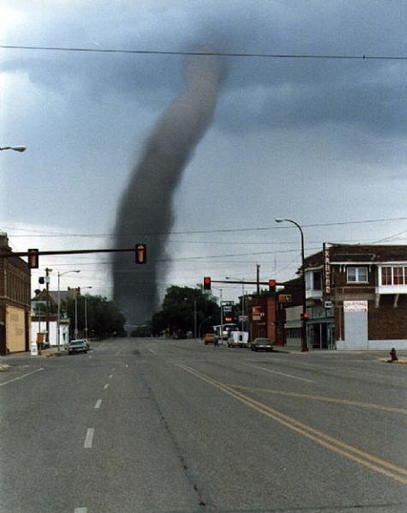
211 tornadoes reported last Wednesday (preliminary count from SPC).
Cars are now thought to be safer than ditches for riding out a tornado on the highway (details below).
1934: last year there was a greater loss of life from a single tornado outbreak than Wednesday's tragic outbreak.
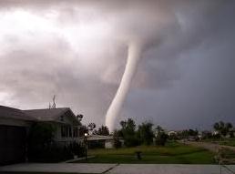
EF-5 tornado reported in Smithville, Mississippi at 3:44 pm. One half mile wide, the tornado produced estimated winds of 205 mph, killing 14, injuring 40.

Ah, The Memories! Friend and Mendota Heights weather spotter Sharon Bertrand poses next to the biggest pile of dirty snow I've ever seen, piled up near the State Capitol in St. Paul. Some locals predict that 25-30 foot pile of sludge won't be entirely gone until the first week of June. Memories of an 86.6" winter.
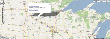
Minnesota Tremor. Minnesota had an earthquake at 2:20 am Friday morning. It was a 2.5 mag, located 39 miles southeast of Fergus Falls, or about 127 miles west- northwest of St. Paul. About 2 dozen residents around the epicenter said they felt the small quake, but no damage was reported. The last measured quake in the state was in 1994, a 3.1 mag in Yellow Medicine County. The most recent Twin Cities quake was on April 24, 1981, and was a 3.6 magnitude near Cottage Grove. More on the minor tremor from KARE-11.
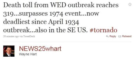
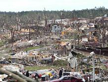
Deadliest Tornado Outbreak Since 1934. Wednesday's outbreak produced the greatest loss of life in 77 years, in spite of Doppler radar, SKYWARN spotters and local media providing continuous coverage of the unfolding horror.
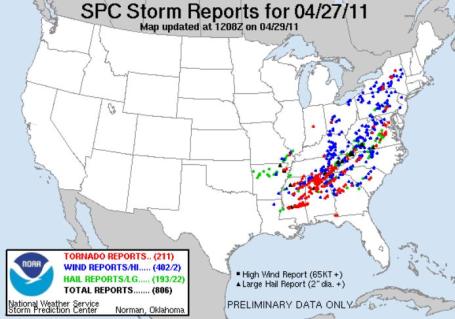
A Staggering Number. The preliminary tornado count for Wednesday's outbreak has risen from 170 (Thurday evening) to 211 (Friday evening). Again, this is a preliminary number. The final count may be lower - many of these tornado reports may be multiple observers seeing the same tornado from different vantage points. SPC details here.
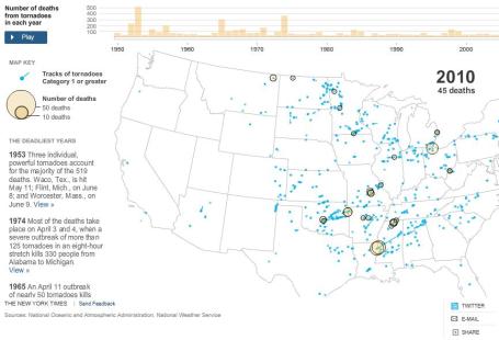
The Deadliest Years. The New York Times has an excellent, interactive graphic showing the recent flurry of tornado touchdowns, and the subsequent death toll: "More than 280 people were killed in Wednesday’s tornado outbreak, bringing the year’s total to over 330 and making it the deadliest year since 1974, when 366 people were killed."
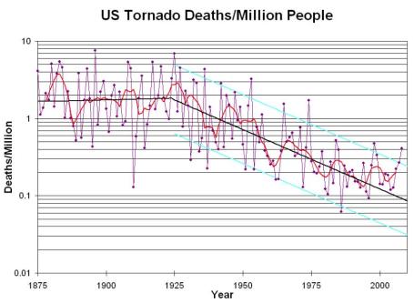
Bucking The Trends. As you can see, the average annual death toll from tornadoes has been on a steady decline since the 1950s. The advent of weather radar (borrowed from the military to track storms), professional storm spotters, improved NWS warnings, implementation of emergency sirens and live media coverage has all contributed to a steady drop in tornado-related fatalities since 1875. More data from the U.S. Severe Weather Blog: "The first dataset is the number of deaths per year from tornadoes in the United States. The National Weather Service archive goes back to 1950. Brooks and Doswell (2002) discussed the long-term history of tornado deaths, drawing on the work of Grazulis (1993) (Grazulis, T. P., 1993: Significant Tornadoes, 1680–1991. Environmental Films, 1326 pp.). Reasonably reliable estimates of deaths per year can be made back to about 1875 by using the Grazulis data. The Brooks and Doswell paper had a graph of the annual death toll normalized by population of the US through 2000. Here is an updated version (through 2008) of that figure, showing that the death toll per million population appears to have leveled off in the last decade or so. The purple points are the annual death rates, the red line is a simple smoother, the solid black line is a long-term trend in two sections (1875-1925, 1925-2000) and the cyan lines are estimates of the 10th percentile and 90th percentile from 1925-2000. Brooks and Doswell (2002) have an extensive discussion of the record and its possible implications."
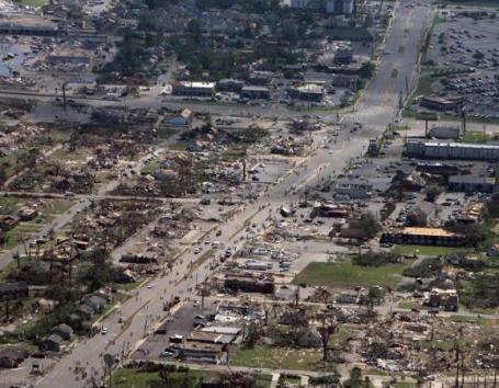
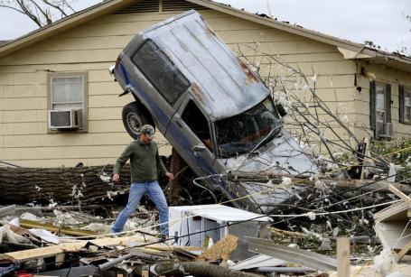
A Chaotic Flurry Of Twisters That Spread Devastation Fast And Wide. A summary of the devastation across the Deep South, focusing on Alabama: "PLEASANT GROVE, Ala. — William Cannon, 46, a maintenance worker in this Birmingham suburb, said everyone knew on Wednesday that a big storm was coming. “The news had been telling us about it for two days,” he said. About 5:15 p.m., his sister called from Mobile, telling him that it looked like a tornado was headed his way. “I’m looking at the TV and the radar said the tornado’s hitting Pleasant Grove right now,” she told him. Then the phone went dead. His windows started to shatter. Part of the roof flew off. His daughter prayed while he grabbed his wife’s godmother, who is 75, and tried to carry her downstairs. But the wind was too strong. It picked him up, blew him down the stairs and nearly carried him out of his house. Meanwhile, his daughter clung to a stair rail and grabbed his wife’s godmother with one hand. He doesn’t know how long the tornado lasted. Some said it was only a minute, but he thought it felt much longer. When he went outside, the sun was shining. The scene of devastation was repeated throughout Alabama, which took the brunt of violent storms that carved a path of destruction through the South on Wednesday. Usually, when tornadoes strike, they will devastate a single town or small area of a state. What was unusual in Alabama was that a mass of twisters ravaged the entire northern half of the state."
PUBLIC INFORMATION STATEMENT
NATIONAL WEATHER SERVICE MEMPHIS TN
812 AM CDT FRI APR 29 2011

...PRELIMINARY RARE EF-5 TORNADO IN MONROE COUNTY MISSISSIPPI...

AFTER A REVIEW OF THE DAMAGE PHOTOS TAKEN DURING THURSDAY/S GROUND
SURVEY AND CONSULTATION WITH NATIONAL EXPERTS...THE NATIONAL
WEATHER SERVICE IN MEMPHIS HAS UPGRADED THE SMITHVILLE TORNADO
RATING TO EF-5 DAMAGE. THIS IS THE HIGHEST RATING FOR TORNADO
DAMAGE AND THE FIRST EF-5 OR F-5 IN MISSISSIPPI SINCE THE
CANDLESTICK PARK TORNADO NEAR JACKSON ON MARCH 3RD 1966.

* COUNTY/COUNTIES: MONROE

* LOCATION/TIME OF EVENT: SMITHVILLE AT 344 PM EDT

* BEGINNING POINT: 34.0517, -88.4236

* ENDING POINT: 34.0731, -88.3814

* RATING: EF-5

* ESTIMATED PEAK WIND: 205 MPH

* PATH LENGTH: 2.82 MILES

* MAXIMUM WIDTH: 1/2 MILE

* FATALITIES: 14

* INJURIES: 40

* SUMMARY OF DAMAGES: 18 HOMES DESTROYED...2 BUSINESSES /POST
  OFFICE AND POLICE STATION/ DESTROYED...8 HOMES WITH MAJOR
  DAMAGE...7 BUSINESSES WITH MAJOR DAMAGE...44 HOMES WITH MINOR
  DAMAGE...AND WATER SYSTEM DESTROYED. MOST TREES EITHER SNAPPED
  OR TWISTED AND DEBARKED. MOST THE HOMES DESTROYED WERE WELL
  BUILT...TWO STORIES...LESS THAN TEN YEARS OLD AND BOLTED DOWN TO
  THEIR FOUNDATIONS. AN 1965 CHEVY PICKUP TRUCK PARKED IN FRONT
  ONE OF THE DESTROYED HOMES HAS NOT BEEN FOUND. ALL APPLIANCES
  AND PLUMBING FIXTURES IN THE MOST EXTREME DAMAGE PATH SHREDDED
  OR MISSING.
What Is An EF-5 Tornado? ABC News has more details on the monstrous tornado that
ripped into Smithville, Mississippi Wednesday afternoon:

"EF-5 tornadoes are extremely rare, but LaDue believes that once
more of the damage is surveyed it is likely that multiple EF-5s touched down in
the South during the tornado outbreak. "The last time ... where more
than one EF-5 was reported in a day was back in 1990," said LaDue. "And if
we have more than two EF-5s out of this then the last time before that was
probably in 1974." The chances of surviving the most powerful tornado possible
without a concrete reinforced safe room or a basement are "pretty slim" LaDue
told ABC News. "People are not trained and prepared," LaDue said. "There is
very little collective knowledge or history, and certainly most people don't have a
memory of what these things can do."
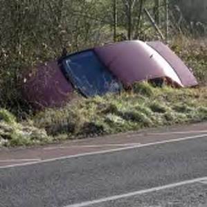
Tornado Safety - Cars Vs. Ditches: A Controversy. Dr. Greg Forbes from The Weather Channel takes a look at a growing debate: is it safer for commuters to ride out a tornado in their cars (with all the built-in safety equipment) or go into a nearby ditch: "About two weeks ago I came back to work after a rare day off and found a letter on my desk from the American Red Cross. It indicated that their organization was changing some of their tornado safety rules. Some of those changes are at odds with safety rules advocated by the National Weather Service (NWS), and that has created a controversy! Click here for the new American Red Cross tornado safety rules. Click here for the NWS tornado safety rules , found within this brochure. Part of the basis for the change in American Red Cross policy was studies by researcher Tom Schmidlin, who found that a relatively small percentage of vehicles are overturned, tossed, and demolished in tornadoes. The NWS recommends that if you are being overtaken in your car by a tornado, then you should get out of the car and into a nearby building or ditch. The new American Red Cross recommendation is that if no building is available, stay in the car - get out of the car and into a ditch only as a last resort. Crouch down with your seat belt on and your head below the windshield level. (That may be hard to do with your seat belt on!)
What are the pros and cons? Here is a partial list.
Hazards of getting out of the car and into a ditch:
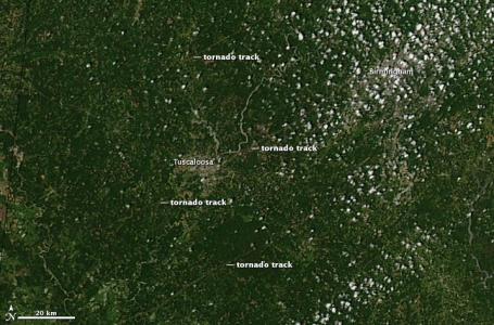
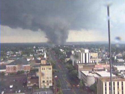
Tornado Tracks From Space. NASA's Earth Observatory web site has high-resolution imagery that shows the paths carved out by Wednesday's tornadoes near Tuscaloosa, including the EF-4 that went right through town. Some of these tornadoes were a mile wide, leaving brown-colored scars on the ground below: "Deadly tornadoes raked across Alabama on April 27, 2011, killing as many as 210 people as of April 29. The hardest-hit community was Tuscaloosa. The top image, acquired on April 28 by the Moderate Resolution Imaging Spectroradiometer (MODIS) on NASA’s Aqua satellite, shows three tornado tracks through and around the city. The lower image, from April 12, shows the area before the storm. The tracks are pale brown trails where green trees and plants have been uprooted, leaving disturbed ground. Though faint, the center track runs from southwest of Tuscaloosa, through the gray city, and extends northeast towards Birmingham. Two other tracks run parallel to the center track. The northernmost track lies in an area where the National Weather Service reported a tornado, but no tornado was reported in the vicinity of the more visible southern track. In the southern region, strong winds were reported."
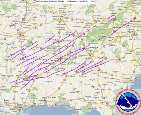
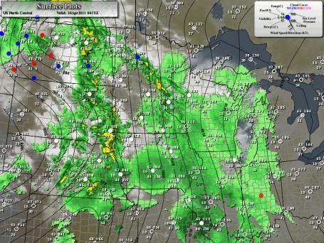
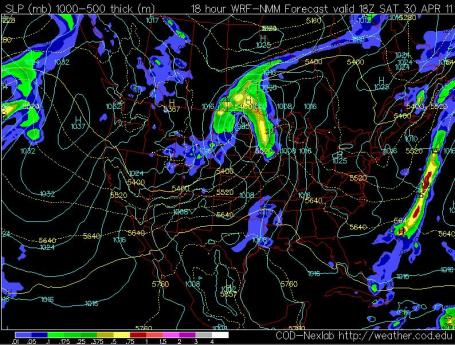
Preliminary Storm Tracks. An almost unimaginable number of long-track tornadoes last Wednesday, according to NOAA.
Storm Chaser Witnesses Alabama Tornadoes. Fox in Tampa documents the storm-chasing adventures of Jimm Edds in this article: "TAMPA - When most of us are running away from deadly tornadoes, Jim Edds is running toward them. He's a storm chaser and happened to be in Tuscaloosa when the string of twisters hit. "Imagine something worse than a category 5 hurricane going through your town, and that's what I saw," Edds said. Jim has been chasing storms for 12 years and does it to capture the awesome force of Mother Nature. "The hail may get you. You're fighting through heavy rain, you're trying to bust out before the part the tornado gets to you -- it's scary," Edds said. Throughout the years, he's become some what of a tornado expert. Jim says he's had some close calls in the past, but knows when to pack up and leave. "You have to know a little bit about their track, and you should be watching it on radar. And you should have your position on radar," Edds explained."
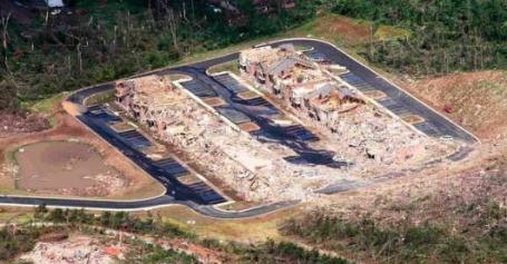
South Assesses The Toll After Deadly Barrage Of Tornadoes. Another good overview of Wednesday's tornado outbreak from the New York Times: "TUSCALOOSA, Ala. — A day after enduring a terrifying bombardment of storms that killed hundreds across the South and spawned tornadoes that razed neighborhoods and even entire towns, people from Texas to Virginia to Georgia searched through rubble for survivors on Thursday and tried to reclaim their own lives. At least 285 people across six states died in the storms, with more than half — 195 people — in Alabama. This college town, the home of the University of Alabama, has in some places been shorn to the slab, and accounts for at least 36 of those deaths. Thousands have been injured, and untold more have been left homeless, hauling their belongings in garbage bags or rooting through disgorged piles of wood and siding to find anything salvageable. While Alabama was hit the hardest, the storm spared few states across the South. Thirty-four people were reported dead in Tennessee, 33 in Mississippi, 15 in Georgia, 7 in Virginia and one in Kentucky. With search and rescue crews still climbing through debris and making their way down tree-strewn country roads, the toll is expected to rise."
University of Louisville Professor Pushes For Storm Prevention To Save Lives. In spite of breathtaking technology we will probably never be able to bring the ultimate death toll down to zero, but further refinements in Doppler radar, GPS-centric smart phone warnings and easier access to reinforced storm shelters will all help to save lives in the years ahead. Here's an article from WAVE-TV: "LOUISVILLE, KY (WAVE) - With all the lives lost in Alabama, a University of Louisville professor is pushing for everyone to be more pro-active in preparing for severe weather. David Simpson is director of the university's Center for Hazard Research. Simpson has been involved in several major studies involving natural disasters, including Hurricane Katrina. He says with all the technology available, the loss of life in the south is unacceptable. Now, he is pushing for change. "What's unique about tornadoes in some sense is that we have some warning that you don't have with earthquakes and say flash floods," said Simpson. "With the available technology, there is less and less reason that we should have anybody that can't get the word from a warning, than what we had say 10 years and 20 years ago." With an outbreak like the one on April 27, Simpson said we may never get to zero deaths. But he says the closer we can get, the better."
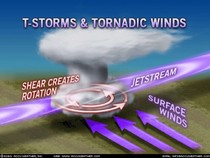
Deadly Storms: What's Driving The Surge? Emily Sohn from Discovery News files a story on the ingredients necessary for the kind of (historic) tornado outbreak we witnessed earlier this week - and whether climate change may be one (of many) contributing factors: "For better and for worse, experts say, these are questions that they can't answer with certainty. Climate change doesn't act in any particular way on the level of tornadoes. What's more, the frequency of tornadoes in one month does not predict how many twisters will strike in the months that follow. Instead, this month's turn of events is a result of a sort of perfect atmospheric storm. Unusually strong winds have been persistently blowing eastward out of the southwest, leading to a layer of relatively cool and dry air lingering aloft above the Midwest and southeast. Beneath that layer, stalled cold fronts have pushed a mass of warm, moist air further north than usual. This particular mixture of conditions -- with cool, dry winds consistently gusting above warm, moist air -- has produced an environment that is ripe for the formation of tornadoes. "It's sort of your classic combination that can produce large death tolls," Brooks said. "Large tornadoes that are very strong are moving through populated areas in a part of the country that has a high mobile home population. It's a combination of factors that we fortunately don't see very often." A weakening La Niña may explain much of this April's damaging nature, said Paul Douglas, meteorologist and founder of Weather Nation, a weather outsourcing company in the Twin Cities, Minn. The natural and cyclical phenomenon, which begins with cooler than normal waters in the eastern equatorial Pacific, has energized the jet stream. For late April, overhead winds are now blowing faster and further south than usual. Meanwhile, water temperatures in the Gulf of Mexico are high for this time of year, which has helped push more warm, moist air into the lower atmosphere. There is also currently an unusually sharp temperature gradient between a colder than normal north and a hotter than average south. Together, these phenomena set the stage for supercell thunderstorms, along with large and violent tornadoes, Douglas said. The La Niña springs of 1974, 1999 and 2008 likewise featured an excessive number of destructive tornadoes."
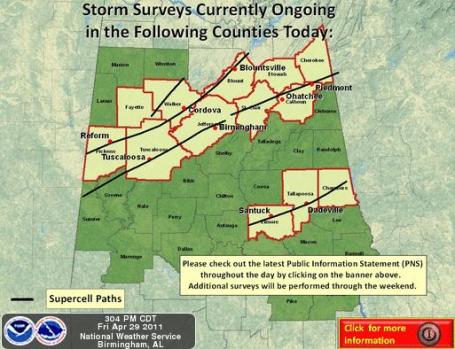
Storm Survey. From the Birmingham office of the NWS:
Storm Surveys will be ongoing throughout the day today across much
of central Alabama. The paths that you see above in Black indicate
the radar indicated tracks of the tornadic supercells, not the
actual tracks of the tornadoes. Track information will be posted as
it arrives. See the latest Public Information Statement regarding the
latest information received from the survey crews throughout the
day.
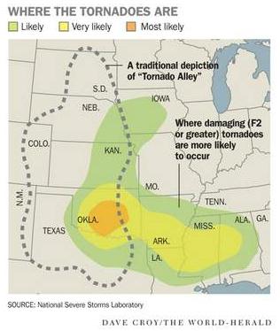
Will Twisters Head Our Way? Omaha.com has a story about the possible implications of the recent tornado outbreak, and whether a weakening La Nina may increase the odds of a severe late spring/summer season over Nebraska (and the rest of the Upper Midwest): "Peak tornado season arrives in Nebraska and Iowa in May and June — so does the violent weather in the South bode ill for this region? After all, Iowa has seen about double the normal number of tornadoes for this point in the year, and the western Iowa town of Mapleton was devastated by a twister on April 9. “It's going to be the luck of the draw, so to speak,” said Harry Hillaker, Iowa state climatologist. “You never know how it's going to play out. But we do expect, for the nation as a whole, it will be a bad year — and that's certainly what's happened already.” A waning La Niña weather pattern is the reason scientists expect a busier-than-normal season, said Adam Houston, a University of Nebraska-Lincoln meteorologist and assistant professor. “It's not a slam dunk, but it's a situation where it's more likely that there will be more tornadoes,” he said. During a La Niña, temperatures across the northern United States tend to be lower than usual, and temperatures across the South tend to be higher than normal. That sets up a sharper contrast between the two air masses and contributes to more instability. Jeff Johnson said 2008 was the last La Nina-influenced tornado season — and that was the year that brought deadly tornadoes to the Little Sioux Scout Camp and Parkersburg, Iowa."
Lessons From The Storm Lost In Florida. Here's an editorial at tampabay.com: "President Barack Obama plans to travel to Alabama today to survey the terrible damage from this week's deadly tornadoes, comfort families and promise federal help. That's how Americans respond following natural disasters: We offer compassion, send volunteers and share the financial pain through private insurance and government assistance. One way or another, the burden is spread. In the South, the death toll from dozens of tornadoes passed 280 and keeps climbing. Neighborhoods have been leveled by winds far stronger than minimal hurricanes, and the costs to rebuild will be steep. Meanwhile, flooding along the Mississippi and Ohio rivers and their tributaries have forced residents in Missouri, Illinois and other Midwest states to flee their homes and businesses. Some damage will be covered by federal flood insurance, but many property owners will have to rely on government loans or other assistance to recover. It takes a mix of community spirit, private insurance and government help to put lives back together."
April Recap. Professor Mark Seeley has a timely review of what has been a pretty forgetable month for Minnesota in his WeatherTalk blog: "For many climate observers in Minnesota, April was cool with mean monthly temperatures ranging from 1 to 3 degrees below normal. Extreme values for the month ranged from 84 degrees F at Preston on the 11th to just 9 degrees F at Embarrass on the 19th. Minnesota reported the coldest temperature reading in the 48 contiguous states just once, on April 14th when Grand Marais recorded a morning low of 14 degrees F. Except for some western Minnesota communities, nearly all observers in the state reported above normal April precipitation. Many had over 3 and 4 inch totals for the month. La Crescent, Grand Meadow, Rushford, and Austin reported over 5 inches in April, more than twice the normal amount. Some locations in northeastern Minnesota reported up to a foot of April snowfall as well."
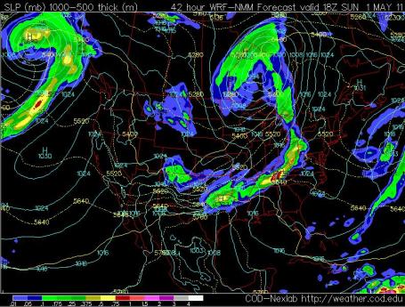
Looks Like Mid March. The pace of weather systems, and the velocity of jet stream winds howling high overhead, remind me more of mid or late March than the last day of April. It may be the lingering effects of La Nina, but it still seems as if Mother Nature has picked up a giant DVR and put our maps into fast-forward. An unusually deep area of low pressure will create a tight pressure gradient (strong contrast in barometric pressure), meaning gusty winds today through midday Sunday - as temperatures fall to Marchlike levels.
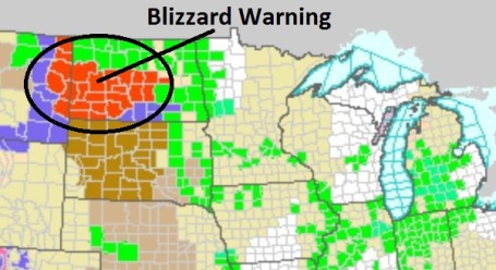
Blizzard Warning On April 30? I must be hallucinating - Bismarck, North Dakota is expecting 3-6" of snow (up to 10" far western North Dakota), with winds gusting as high as 55 mph, creating white-out conditions. Surreal, considering the sun is as high in the sky as it was in mid August.
Saturday Showers. The best chance of rain today comes during the morning and midday hours, a wind shift to the west/northwest begins to dry us out this afternoon - the sun may peek through by eveing. Outdoor events after 3 pm should be mostly-dry, but expect lingering clouds and a damp wind. Wish I had better news.
Sunday: Marginally Better (But Chilly For May). Cool, Canadian exhaust on the backside of a strong storm over Ontario will keep most of Minnesota in the 40s tomorrow, 50 possible far southern counties. Clouds will dominate, winds slowly easing during the day - the best chance of showers (rain and wet snow) over far northern Minnesota.
Reluctant Spring of 2011 Back On Track? I'm expecting 4, maybe 5 days above 60 next week, and the GFS pulls 70-degree air into the metro area around May 10-11. Seems kind of pathetic, making a big deal out of 60s and 70s, doesn't it? I'd love to see an 80 in here, but after last Wednesday's tornado-carnage in the Deep South, I'm fearing what other (unwelcome) weather might accompany the first few surges of 80s. Based on the trends I'm expecting another unusually severe summer for Minnesota. Don't fight the trends, and right now the trends are worrisome.
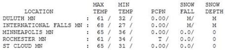

An All-Too Brief Glimpse Of Spring. Well, we had spring, for about 4-5 hours from 9 am until about 2 pm, when clouds thickened, leaking rain on much of the area by evening. Highs ranged from 47 at Grand Marais to 65 in St. Cloud and the Twin Cities.

RIP Max. 1996-2011. We picked up Max when our boys were still small, during my stint in Chicago. He was a gentle, loving pup - barked a little too much, but we got used to it. We couldn't train him to do much of anything (most likely our fault). Again, it didn't matter. He had character, spunk - loved to chase rabbits and squirrels, followed us around everywhere, loved to cuddle on the couch. A Cavalier King Charles Spaniel, Max was the friendliest dog you'd ever want to meet - he'd probably lick an intruder to death - not a violent bone in his furry, little black & tan body. He provided me with late-night weather intelligence, scratching our bed furiously when lightning was barely visible on the horizon. No, he didn't like lightning - thus, the expression "Doggie Doppler." Max was a good soul; we all became very attached to this wonderfully hairy little creature, more than we thought possible. Yes, dogs and cats become an inseparable part of our families, and we mourn their passing as we might a sibling or favorite uncle - as odd as that sounds. Max passed on yesterday in a tragic accident, a real blow for our family. We've loved him mightily for 15 wonderful years. He filled our lives with joy. Hope to see you on the other side Max. We miss you more than you'll ever know...
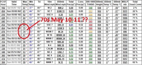
Paul's SC Times Outlook for St. Cloud and all of central Minnesota:
TODAY: Showers through midday. Windy and drier by afternoon - some clearing by evening? Winds: SW 15-25. HIgh: 57
SATURDAY NIGHT: Partial clearing, chilly. Low: 33
SUNDAY: Mostly cloudy, windy and raw for the first day of May. Few sprinkles possible. Showers of rain (and wet snow) over far northern MN. Winds: W 15-30+. High: 47
MONDAY: Sun returns, getting better again. Low: 34. HIgh: 58
TUESDAY: Plenty of mild sun. Low: 37. High: 63
WEDNESDAY: More clouds, stray T-storm? Low: 44. High: near 60
THURSDAY: Unsettled, risk of a T-shower. Low: 43. High: 61
FRIDAY: Cooler, few PM pop-up showers. Low: 42. High: 56
Tornado Safety
Wednesday's historic (horrific) tornado outbreak triggered the greatest loss of life since 1934. It was a wake-up call for the rest of us. A La Nina-energized jet stream may increase the potential for more severe storms here this summer. According to the local National Weather Service office, "A year that has had an April with a top ten number of tornadoes in the country has led to an above normal number of tornadoes in MN and WI six of those ten years. We have to be ready. The safest place: in your basement, under the stairs. Otherwise a small, windowless room on the ground floor is the best place to ride out a tornado (closet, bathroom, even a bathtub). For 3-6K you can construct a concrete and steel-reinforced "safe room" - able to withstand winds over 150 mph. Mobile homes are most vulnerable: make sure there's a shelter nearby.
Nothing severe in sight, just a showery Saturday morning, giving way to partial clearing by evening. Clouds and an annoyingly cool breeze (gusting to 30 mph) linger Sunday, but as many as 4 days in a row above 60 are shaping up for next week. I'm cheering on these long-overdue warm fronts, but I have a gut feel that this may be another rough severe storm season.
Top Climate Scientist On The Monster Tornadoes: It's Irresponsible Not To Mention Climate Change. Is there a scientifically verifiable link? Here's an update from the Wonk Room: "In an email interview with ThinkProgress, Dr. Kevin Trenberth, one of the world’s top climate scientists, who has been exploring for years how greenhouse pollution influences extreme weather, said he believes that it is “irresponsible not to mention climate change” in the context of these extreme tornadoes, adding that the scientific understanding of how polluting our atmosphere with billions of tons of greenhouse gases affects tornadic activity is still ongoing: It is irresponsible not to mention climate change. … The environment in which all of these storms and the tornadoes are occurring has changed from human influences (global warming). Tornadoes come from thunderstorms in a wind shear environment. This occurs east of the Rockies more than anywhere else in the world. The wind shear is from southerly (SE, S or SW) flow from the Gulf overlaid by westerlies aloft that have come over the Rockies. That wind shear can be converted to rotation. The basic driver of thunderstorms is the instability in the atmosphere: warm moist air at low levels with drier air aloft. With global warming the low level air is warm and moister and there is more energy available to fuel all of these storms and increase the buoyancy of the air so that thunderstorms are strong. There is no clear research on changes in shear related to global warming. On average the low level air is 1 deg F and 4 percent moister than in the 1970s. Climate scientist Michael Mann explains further that “climate change is present in every single meteorological event”: The fact remains that there is 4 percent more water vapor–and associated additional moist energy–available both to power individual storms and to produce intense rainfall from them. Climate change is present in every single meteorological event, in that these events are occurring within a baseline atmospheric environment that has shifted in favor of more intense weather events."
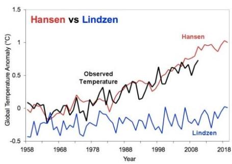
Which Side Of The Global Warming Debate Has Been Right? An estimated 97.4% of peer-reviewed climate scientists believe that climate change is real, and man is a large contributing factor in AGW. So who's predictions have been closer to reality, Dr. James Hansen (NASA's Goddard Institute for Space Studies) or Dr. Richard Lindzen (MIT)? Skeptical Science has a good overview here: "With policymakers and the public receiving such diametrically opposed messages from these two prominent scientists, it's understandable that many people simply don't know what to believe. One way to compare the credibility of the two sides is to look back at the history of their research, comments, and predictions, and see how accurate they've turned out to be. Here we look at Dr. James Hansen of NASA's Goddard Institute for Space Studies (GISS) and Dr. Richard Lindzen of the Massachusetts Institute of Technology (MIT) who have both been researching climate science since the field of climatology really began to develop in the early 1970s--and while both agree that humans are causing climate change, they disagree on how bad the impacts will be. Over the past four decades, Dr. Hansen, who is now widely considered one of the foremost climate scientists in the world, has grown increasingly concerned about the threat posed by man-made global warming and climate change, and our failure to seriously address this threat. Dr. Lindzen, on the other hand, has consistently been skeptical that human-caused global warming is anything to worry about. Although he does not currently dispute that our greenhouse gas emissions have caused a measurable amount of warming, Dr. Lindzen believes the climate is not very sensitive to changes in atmospheric greenhouse gases. The message from Dr. Hansen has consistently been that global warming is a growing threat which we're running out of time to address, while the message from Dr. Lindzen has consistently been that it's nothing to worry about. Dr. Hansen was the lead author of a famous study in 1988, whose results he presented to US Congress that year, using a climate model to project how much the planet would warm over the next few decades in three different scenarios. In Scenario A, human greenhouse gas emissions accelerated rapidly. In Scenario B, which has turned out to be closest to reality, greenhouse gas emissions increased at a steady rate. In Scenario C, greenhouse gas emissions rose until flattening out in 2000, basically assuming the world would take major steps to reduce our emissions by that time."
No comments:
Post a Comment