1-2" slushy snow possible Friday night and early Saturday morning.
2/10th's of an inch of snow makes this the 4th snowiest winter on record for MSP.
45 F. high predicted on Saturday. Any snow that falls early Saturday will have melted by late morning.
46 number of tornadoes reported in Iowa so far in 2011.
9 number of tornadoes reported in Wisconsin so far in 2011.
0 tornadoes so far in Minnesota (17 reports of 1"+ hail, 12 reports of damaging winds so far statewide). Details from SPC below.
On Our Way To #4? At 84.7" so far this winter season the Twin Cities metro area is already holding at #5 on the list, another 2/10th's of an inch of snow brings us up to #4 on the list. That appears likely late Friday night and Saturday morning in the metro area. Will we get to the #3 spot: 88.9"? Doubtful with this next system, but I wouldn't rule it out entirely. Source: NOAA.
Slushy Possibilities. The good news: we won't see a foot of snow (at least in or near the metro area). The bad news: you may do a double-take when you wake up Saturday morning and see a fresh coating of white on your (once-green) lawn, maybe 1-2". It won't last - any slush will melt within a few hours. No worries.
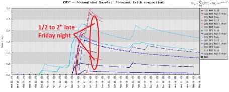
Heaches, Migraines and Gray Hairs. O.K. The "snow event" is (in theory) 24-36 hours away. And yet there is still a considerable spread in the model output, anywhere from a coating (1/2") to nearly 3". I don't think this will be "plowable", more of a nuisance snow event late Friday night and early Saturday.
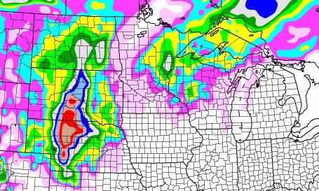
Projected Track. An ideal storm track for heavy snow (or rain for that matter) runs from near Des Moines to La Crosse to Eau Claire, close enough to pull the heaviest precipitation bands into the metro, yet far enough south/east for a steady supply of cold air to keep precip falling as snow. Friday night the track is about 200 miles too far south/east for the heaviest bands to set up close to home.
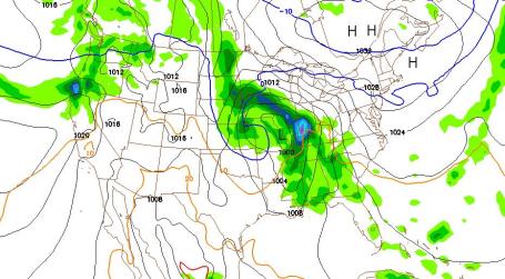
Friday Evening. The NAM model shows an area of low pressure centered near St. Louis, a swirl of moisture approaching from Iowa, spreading into southern Minnesota (probably as a cold rain) Friday afternoon or evening.
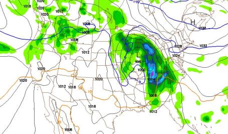
Saturday Morning. By 7 am Saturday the storm is forecast to be near Rockford, Illinois, moving rapidly north and east. It looks like a fairly quick "burst" of wet snow late Friday night - I'm leaning toward an inch of slush, give or take.
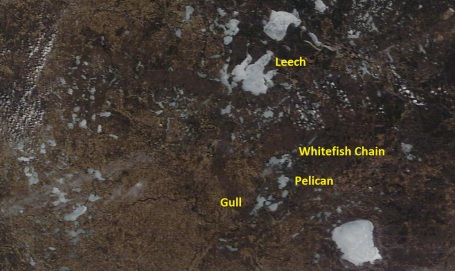
Imminent Ice-Out. Ice is off Lake Minnetonka and White Bear Lake, a few days away from coming off Lake Mille Lacs, Gull, Pelican and the Whitefish Chain. 250 meter resolution image taken Wednesday courtesy of NASA's "Terra" satellite.
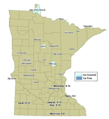
Ice-Out Update. If you're keeping score (and who among us isn't?) ice officially came off White Bear Lake and Minnetonka on April 13. At the rate we're going ice will be off most lakes in the Brainerd Lakes area within the next week. Source: MN DNR.

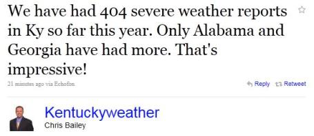
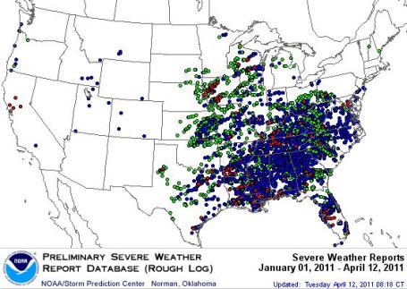
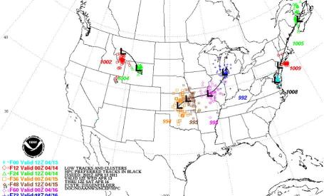
Lucky So Far. These are the latest severe weather observations so far in 2011 from SPC, the Storm Prediction Center in Norman, Oklahoma. So far Iowa has seen 46 tornadoes, 9 in Wisconsin, none so far in Minnesota. Look at the concentration of severe wather reports across the southeast. A total of 310 tornadoes have been observed nationwide as of April 13.

U.S. Lagging In Using Technology, Study Says. Some troubling news from the New York Times: "The United States continues to lag other nations in its use of computing and communications technology, according to an annual study issued Tuesday by the World Economic Forum. For the second consecutive year, the United States finished fifth in the study’s comparison of 138 countries that make up 98.8 percent of the world’s total gross domestic product. Sweden was first, followed by Singapore, Finland and Switzerland. These rankings, for 2010, are based on an index of 71 economic and social indicators, as diverse as new patents, mobile phone subscriptions and availability of venture capital. The annual reports began in 2001, after the collapse of the Internet bubble. The World Economic Forum, based in Davos, Switzerland, holds that technological progress is the principal driver of innovation, productivity and efficiency.


Reinventing Television? Syzygy Labs imagines a universal app that will augment the TV, so users can get info related to what they’re watching, see what their friends are watching or even buy advertised products instantly. Post courtesy of theawesomer.com.
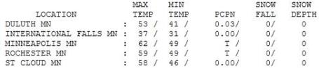
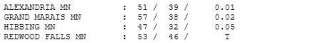
Cooling Down. Highs held in the 50s across most of Minnesota Wednesday, inching up to 62 in the Twin Cities, 58 at St. Cloud, a brisk 47 at Hibbing, where .05" rain fell.
Paul's SC Times Outlook for St. Cloud and all of central Minnesota:

TODAY: Lot's of clouds, cool breeze. Winds: E 10-20 High: 48
THURSDAY NIGHT: LIngering clouds, still cool and damp. Low: 35
FRIDAY: Windy, cold rain arrives PM hours. High: 44
SATURDAY: Slushy coating - coating to 1 or 2" early? PM sunshine. Low: 30. High: 45
SUNDAY: Sunny intervals. Any snow should be long gone. Low: 29. High: near 50
MONDAY: Light rain or drizzle possible. Low: 32. High: 46
TUESDAY: Storm passes south, gray sky. Low: 34. High: 49
WEDNESDAY: Clouds increase, late PM rain possible. Low: 33. High: 51

4th Snowiest?
Not sure my heart, back (or psyche) can take another heavy, wet snowfall. But 2/10th's of an inch? I can handle that. That's all we need for this to become the 4th snowiest winter on record for the Twin Cities.
Early model runs were a bit horrifying, hinting at some truly outrageous (double digit) snowfall totals. But between a dry breeze much of Friday from a stubborn high pressure system, a temperature profile warm enough for mostly-rain Friday night, and a storm track 200 miles too far south/east, I suspect we'll escape with a coating to an inch, maybe 2" north/east of St. Paul. But 3-6 " may fall on the Duluth area, with over a foot for parts of the Dakotas.
Here's the deal: any slush in your yard at dawn on Saturday melts within 3 hours; highs near 50s next week as storms pass south of Minnesota. Another significant storm (more rain than snow) is shaping up for Saturday, April 23.
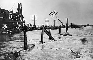
Finally, today marks the anniversary of Minnesota's deadliest tornado. 72 people in Sauk Rapids died from a 1/2 mile wide, EF-4 tornado on April 14, 1886, 11 deaths in one wedding party in Rice. The tornado helped to make St. Cloud central Minnesota's dominant city; Sauk Rapids was leveled in under 15 minutes.
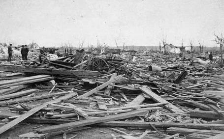
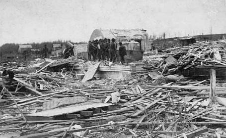
Tornado Disaster. Photos from Sauk Rapids taken after the April 14, 1886 tornado that leveled much of the city, killing 72 people. The bottom image is from the court house in Sauk Rapids. The EF-4 tornado (1/2 mile wide) set the city of Sauk Rapids back for years, ultimately allowing St. Cloud to become central Minnesota's largest city. Source: Wikipedia.
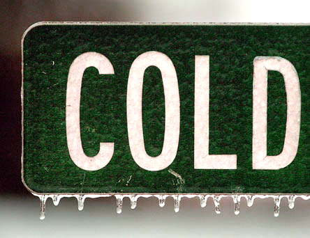
Chilling: Cold Snaps Will Persist In A Warming World. Here's a story from ouramazingplanet.com: "Although the planet is warming overall, events of extreme cold are still likely to persist on each continent for the next century, researchers say. The Southeast and Northwest in the United States may be especially vulnerable to these chills, scientists added. Investigators at Oak Ridge National Laboratory used nine global climate models assuming moderate levels of greenhouse gas emissions (the gases that build up in the atmosphere and trap heat) to compare the climates of 1991 to 2000 with 2091 to 2100. All nine models found that climate would overall experience warming at the end of the century. However, they forecast that events of extreme cold would still happen, although they would occur less frequently. "The fact that future extreme cold events will continue to be at least as intense and long-lasting in many regions of the world, even under warming scenarios, may not seem intuitive," researcher Auroop Ganguly, a civil and environmental engineer at Oak Ridge National Laboratory, told OurAmazingPlanet.


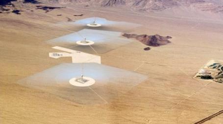
Google Invests $168 Million In World's Largest Solar Power Tower Plant. An update from gizmag.com: "Google has chipped in a US$168 million investment in what will be the world's largest solar power tower plant. To be located on 3,600 acres of land in the Mojave Desert in southeastern California, the Ivanpah Solar Electric Generating System (ISEGS) will boast 173,000 heliostats that will concentrate the sun's rays onto a solar tower standing approximately 450 feet (137 m) tall. The plant commenced construction in October 2010 and is expected to generate 392 MW of solar energy following its projected completion in 2013. Although solar power tower development is currently less advanced than the more common trough systems, they offer higher efficiency and better energy storage capabilities. Parabolic trough systems consist of parabolic mirrors that concentrate sunlight onto a Dewar tube running the length of the mirror through which a heat transfer fluid runs that is then used to heat steam in a standard turbine. Solar power tower systems such as the ISEGS on the other hand focus a large area of sunlight into a single solar receiver on top of a tower to produce steam at high pressure and temperatures of up to 550 ° C (over 1,000° F) to drive a standard turbine and generator. The ISEGS also uses a dry-cooling technology that reduces water consumption by 90 percent and uses 95 percent less water than competing solar thermal technologies. Water is also recirculated during energy before being reused to clean the plant's mirrors."
No comments:
Post a Comment