49 F. high on Friday in St. Cloud.
40 mph: peak wind gust reported yesterday.
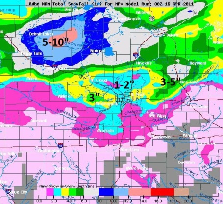
1-3" slushy snow possible across central Minnesota this morning - should melt within 3-4 hours.
4-8"+ possible closer to Detroit Lakes, Brainerd and the Duluth area.
Winter Weather Advisories posted up north, warnings for the North Shore of Lake Superior.
80 tornadoes reported from Illinois to Alabama and Mississippi on Friday.
.38" of additional rain predicted next Tuesday (GFS
model).
49 F. predicted high for Sunday afternoon.
60 degree highs expected to return to the Twin Cities after Monday, April 25.
 Flashback: April 15, 1983
. Things could be worse. Much worse. On April 15, 1983 13.6" of snow fell on the Twin Cities, setting an all-time record for April snow in the metro area. I
had just gotten to Minnesota one month earlier, and I distinctly remember thinking, "what have I gotten myself into?"
 Nuisance To Plowable.
 Although amounts will be close to 1-3" in the St. Cloud metro (mainly on lawns and fields), as much as 5-10" of snow is possible from Detroit Lakes to the Brainerd area. A little April snowmobiling anyone? Didn't think so.
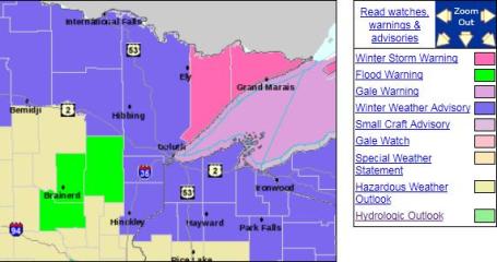 Winter Weather Advisory
. Not sure why a watch isn't issued up north. Duluth may wind up with 4-8" snow from this fast-moving storm. Warnings are posted for the North Shore of Lake Superior, where some 10" amounts are expected.
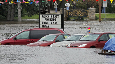 Flood Update
. I asked local National Weather Service Meteorologist In Charge, Dan Luna, for a quick update on Minnesota's flood potential. Here was his response: "
Rivers will continue to recede and I don't expect will see a third crest from this current storm system and with a relatively dry three days ahead (meaning less than 0.35 inches of precipitation, we will see a continued fall. With the system on days 4 and 5, well, we will have to see. Too early at this point in the game. At any rate, we have and continue to be very fortunate with the precipitation patterns." Latest from NOAA:
* FLOOD WARNING FOR RAIN AND PREVIOUS SNOW MELT IN...
EXTREME NORTH CENTRAL SIBLEY COUNTY IN CENTRAL MINNESOTA...
MCLEOD COUNTY IN CENTRAL MINNESOTA...
NORTHWESTERN CARVER COUNTY IN EAST CENTRAL MINNESOTA...
WESTERN HENNEPIN COUNTY IN EAST CENTRAL MINNESOTA...
WRIGHT COUNTY IN CENTRAL MINNESOTA...
* UNTIL 400 PM CDT MONDAY.
* LAW ENFORCEMENT AND EMERGENCY MANAGEMENT OFFICIALS CONTINUE TO REPORT LOCALIZED FLOODING PROBLEMS.
* SOME LOCATIONS THAT WILL CONTINUE TO HAVE FLOODING PROBLEMS
INCLUDE AREAS ALONG THE BUFFALO CREEK...SOUTH FORK OF THE
CROW...NORTH FORK OF THE CROW AND THE CROW RIVER.
Minnesota WeatherTalk. Professor Mark Seeley has an update on Minnesota weather in his always-insightful blog post: "Thanks to last weekend's thunderstorms several northern Minnesota observers now report above normal precipitation for the month. Some of these include:
Warroad 2.11 inches, 0.90 inches above normal
Cass Lake 2.33 inches, 0.50 inches above normal
Little Fork 2.23 inches, 0.31 inches above normal
International Falls 1.99 inches, 0.61 inches above normal
Kabetogama 2.17 inches, 0.67 inches above normal
Southeastern Minnesota observers also reported heavy rainfall last weekend, some totaling over 2 inches. Grand Meadow (Mower County) reported 2.44 inches on April 10th, breaking the all-time state record for the date of 2.40 inches at Bricelyn (Faribault County) in 1947. Warmer than normal temperatures during the first two weeks of April have helped speed along the ice out on southern Minnesota lakes. Many lakes from Albert Lea to White Bear Lake have seen the ice disappear over this past week. A cooling trend from now until the last week of the month will likely slow this process and the state's remaining lakes."
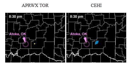
On Target. A friend of mine, Andrew Revering, has created an innovative online service (
Tornado Target) that attempts to pinpoint, many hours in advance, where a tornado may touch down. A tall task, but on Thursday his algorithms correctly placed a large, violent tornado over Atoka, Oklahoma,
9 hours in advance! Some details: "
At 10:16 a.m. the forecast graphics for Thursday April 14, 2011 became available on the TornadoTarget.com web site. They indicated that a tornado may strike the small town of Atoka, OK at between 7:15 and 7:30 p.m....over 9 hours later a large, violent tornado did hit Atoka, OK at 7:23 p.m. The custom computer model run indicated a tornado outbreak in parts of Kansas and Oklahoma. Two proprietary indices; APRWX TOR developed by Andrew Revering and CEHI by Shawn Hewitt focused on two areas in particular. One was northern Oklahoma and one was southern Oklahoma. Both areas did confirm tornadoes very near their respective target areas, but this case study focuses on the southern target. Above are animations of the forecast output issued at 10:16 am. The city hit by the tornado, Atoka, OK, is marked. Note the forecast has the tornado going through Atoka at between 7:15 and 7:30 p.m."
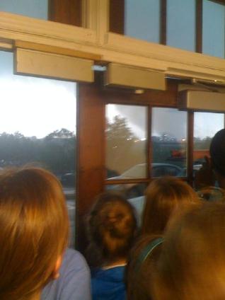
Hey Kids, Let's Run To The Window And Watch The Tornado! Bad idea. This is one of the first things they tell you: avoid large rooms, auditoriums (mobile homes) and windows, which can be (instantly) turned into shrapnel when a tornado approaches, due to high wind speeds AND a sudden drop in air pressure. Thanks to
yfrog.com and "ChristianGuy" who tagged the photo with: "
Well, a tornado just strolled on by. No biggy." Uh huh.
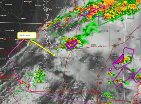
A Link Between "Gravity Waves" And Tornadoes? Brad Panovich from WCNC
tweeted a radar composite that clearly shows gravity waves helping to initiate major tornadogenesis. More on the phenomenon from NASA
here, another explanation
here from Universe Today. We're still learning how ingredients in the atmosphere converge to produce the largest, most violent, long-lasting tornadoes.
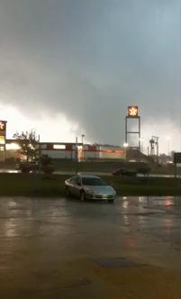
Clinton, Mississippi Tornado. Check out this
YouTube footage of the tornado that hit Clinton Friday afternoon. It touched down around 11 am local time.
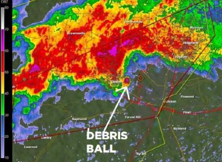
Tornado "Debris Ball". Usually tornadoes are too small to show up on Doppler radar. We can detect the (spinning) parent thunderhead, the mesocyclone that spawns the tornado. But in the case of yesterday's (large/violent) tornado that hit Clinton, Mississippi the actual
debris cloud - the tornado itself - showed up on Doppler radar. Amazing.
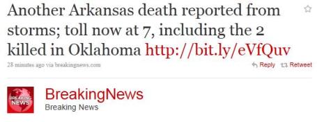
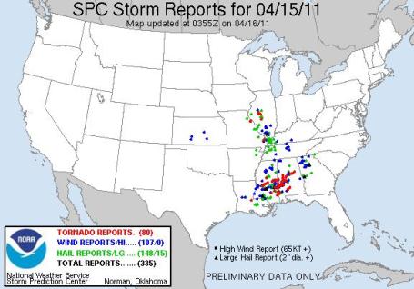 Major Outbreak - At Least 80 Tornadoes Reported Friday
. From Illinois southward to Mississippi and Alabama, SPC counted 80 tornadoes as of 11 pm Friday night. A complete rundown of the tornado oubreak is
here.
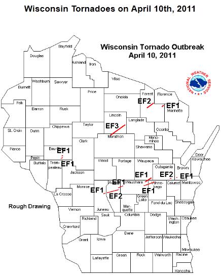
April 10 Tornado Outbreak Sets New Record For Wisconsin. Last Sunday was a volatile day for the Badger State, a total of
12 tornadoes reported across Wisconsin.
More from the Chanhassen office of the NWS: "
On Sunday April 10th, early season severe thunderstorms with tornadoes, winds, and hail developed across western Wisconsin and southeast Minnesota and evolved eastward. For western and northern Wisconsin, the 12 tornadoes for an early season event were quite anomolous, making this event the largest April outbreak on record in Wisconsin."
 TV Meteorologist Thrives In Social Media Tornado.
 I have to hand it to James Spann, by far the #1 on-air meteorologist in the state of Alabama. He combines live Doppler with a steady stream of tweets, photos, video clips, FB posts and weaves together an amazing commentary as he tracks tornadic storms across the state. Here's the
story from Lost Remote: "
To get an idea of the popularity of James Spann, all you have to do is look at his Facebook and Twitter accounts. As far as I can tell, Spann has more combined Twitter fans (19,837) and Facebook followers (42,376) than any local TV talent in the country. For a meteorologist in Birmingham, Alabama — the nation’s 40th TV market — that’s downright impressive. As tornadoes swirled through Alabama today, Spann was live on ABC 33/40, two radio stations and UStream, tracking storms (like “bullets from a gun,” he said) and urging residents to take cover. While on the air, Spann wasn’t able to post on Facebook or Twitter very often, but the social conversation around him was a storm of its own — and he kept an eye on it on his laptop. On both Facebook and Twitter, fans and viewers sent him a steady stream of messages — sometimes several per minute — of damage reports, weather questions and general praise."
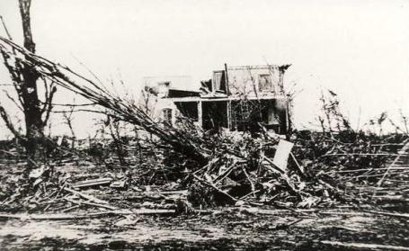
125 Years Later, "Cyclone" Still Felt In Sauk Rapids. Up until the 1950s any storm (from a synoptic scale low pressure system 1,000 miles wide to a tornado, was referred to as a "cyclone". Minnesotans had "cyclone shelters". The reality: up until 1952 forecasters were prohibited from using the term "tornado" for fear of inciting public panic that might be worse than anything the actual tornado could do. I know, looking back it was an odd restriction, and may have ultimately increased the loss of life in some cases. Stephanie Dickrell from the SC Times has a
terrific story about the massive tornado that hit Sauk Rapids and St. Cloud on April 14, 1886 - it still has the distinction of being Minnesota's deadliest tornado on record: "
Showing the strength of the storm, a 1-ton safe in Sauk Rapids was reported as lifted and carried. Witnesses could not see any drag marks, supposing the safe had actually been lifted by the storm. A 300-pound attorney, Thomas Van Etten, was reportedly picked up and carried several feet, and found covered in clay and mud but safe, save for a few bruises. Physicians arrived from St. Paul, Minneapolis, Anoka and Brainerd to help the wounded and dying. Provisions, clothing, lumber and building materials poured in. Nurses arrived from St. Paul and Minneapolis.It was reported that 109 buildings in St. Cloud were damaged, valued at $176,000. In today’s dollars, that’s more than $4 million, according to measuringworth.com. In Sauk Rapids, 49 buildings were destroyed, with damages amounting to $300,000, or more than $7 million today."
* The Schwartz house (photo above) was one of the first houses to be hit by the tornado in St. Cloud (courtesy of the Benton County Historical Society).
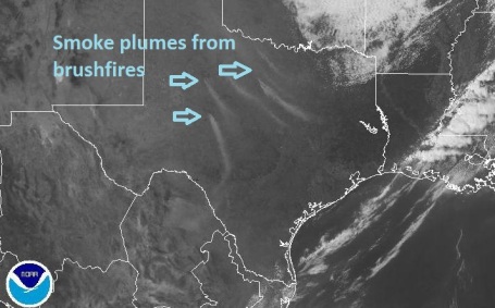 Texas Brushfires From Space
. Thanks to
high-res NOAA visible satellites you can see the smoke plumes from wildfires in Texas, smoke being swept hundreds of miles downwind.
 Public Education Is Biggest Need In U.S. Tsunami Prepardness
. Barbara Scholl is the Chair of the Division of Earth and Life Sciences. She shares some
insights from the Japan disaster and what that means for coastal residents of the USA, especially in the Pacific Northwest, where the tsunami risk is greatest: "
My heart goes out to the people of Japan as they clean up and rebuild following the devastating earthquake and tsunami. The earthquake struck with almost no warning, and reports indicate that tsunami waves as high as 33 feet in some areas reached Japan’s northeast shores within 30 minutes of the 8.9 magnitude quake. Many of us have seen the incredible videos that show waves of water and debris tragically washing away homes, businesses, and schools, and tossing cars, ships, and planes as if they were toys. Because the Japanese tsunami formed close to shore and traveled to land quickly, there was simply not adequate time to evacuate everyone from such a large area before the waves hit the coast. Similar conditions prevailed in the Indian Ocean tsunami of 2004 with the added problem that people were not well educated about the warning signs and dangers of a tsunami. It was widely reported that many people in Sumatra and other areas even rushed towards the receding waves to gather fish from the sea floor. Japan is among the most prepared of all nations for earthquakes and tsunamis. A relatively high percentage of its buildings are engineered to withstand earthquakes with shock absorber-like features that give buildings flexibility to move with seismic waves instead of collapsing. Japan has lined about 40% of its coastlines with concrete seawalls, breakwaters or other structures meant to protect the country against high waves and typhoons, or even tsunamis. But perhaps the single most important survival factor of all is that Japan’s people are well educated from a young age on how to respond to both earthquakes and tsunamis. This is likely the reason that, despite significant losses of human life, even more lives were not lost, given that 30-foot high waves swept over an area with about 1 million people, and pushed more than 2-miles inland. Many of the people knew what to do."
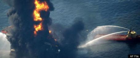
Experts Fear Another Oil Disaster. Was the 200 million gallon BP oil spill into the Gulf of Mexico last year the tip of an oily iceberg? Here's an excerpt from a Friday
article at Huffington Post: "
NEW ORLEANS -- With everything Big Oil and the government have learned in the year since the Gulf of Mexico disaster, could it happen again? Absolutely, according to an Associated Press examination of the industry and interviews with experts on the perils of deep-sea drilling. The government has given the OK for oil exploration in treacherously deep waters to resume, saying it is confident such drilling can be done safely. The industry has given similar assurances. But there are still serious questions in some quarters about whether the lessons of the BP oil spill have been applied. The industry "is ill-prepared at the least," said Charles Perrow, a Yale University professor specializing in accidents involving high-risk technologies. "I have seen no evidence that they have marshaled containment efforts that are sufficient to deal with another major spill. I don't think they have found ways to change the corporate culture sufficiently to prevent future accidents."
Do Cell Phones Cause Brain Cancer? I just installed a hands-free Bluetooth system for my car - looking for excuses now not to hold my trusty iPhone 4 up to my head. There seems to be enough evidence, anecdotal and otherwise, to exercise caution with mobile phones, and limit the time they're inches away from our brains. Here's an
exhaustive story about the state of the science from the New York Times: "
On Jan. 21, 1993, the television talk-show host Larry King featured an unexpected guest on his program. It was the evening after Inauguration Day in Washington, and the television audience tuned in expecting political commentary. But King turned, instead, to a young man from Florida, David Reynard, who had filed a tort claim against the cellphone manufacturer NEC and the carrier GTE Mobilnet, claiming that radiation from their phones caused or accelerated the growth of a brain tumor in his wife.“The tumor was exactly in the pattern of the antenna,” Reynard told King. In 1989, Susan Elen Reynard, then 31, was told she had a malignant astrocytoma, a brain cancer that occurs in about 6,000 adults in America each year. To David Reynard, the shape and size of Susan’s tumor — a hazy line swerving from the left side of her midbrain to the hindbrain — uncannily resembled a malignant shadow of the phone (but tumors, like clouds, can assume the shapes of our imaginations). Suzy, as she was known, held her phone at precisely that angle against her left ear, her husband said. Reynard underwent surgery for her cancer but to little effect. She died in 1992, just short of her 34th birthday. David was convinced that high doses of radiation from the cellphone was the cause."
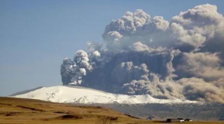
New Coatings Could Protect Jet Engines From Volcanic Ash. Pilots routinely fly around threats, like thunderstorms, and regions of extreme turbulence over moutainous areas, but volcanoes present a unique challenge, and threat. Ash pulled into jet turbines can cause them to freeze up (and stop working altogether), which can quickly turn a jet aircraft into a giant paperweight with potentially tragic results. Gizmag.com
reports on a new product which may reduce the risk of volcano-related headaches: "
Following last April's historic eruption of the Eyjafjallajökull volcano in Iceland, commercial flights were cancelled within most of Europe for several days – it was the largest disruption of air travel since the Second World War. Well, while no one is suggesting that airliners could now merrily fly right through clouds of ash, researchers from Ohio State University (OSU) have developed a coating that they say could allow jet engines to better withstand small amounts of volcanic ash that are ingested over time. The metallic parts of jet engines are already coated with a ceramic thermal barrier coating, that allows them to withstand the 2500F (1371C) temperatures that occur during regular operations. When volcanic ash is sucked into an engine, however, it melts onto the coating and penetrates it. That ash becomes a brittle glass upon cooling and it flakes off, taking the coating with it."
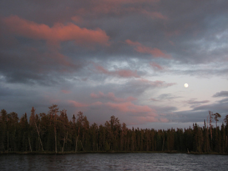
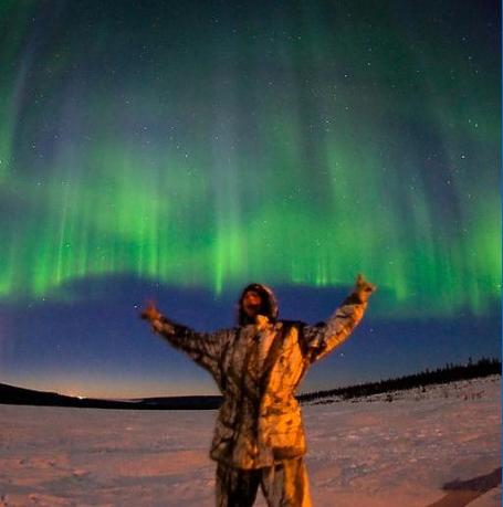
April Auroras.
Spaceweather.com has an entry on the Aurora Borealis, which has been quite spectacular in the last week or so over far northern latitudes, visible as close to us as Wisconsin: "
The display came at the tail end of a geomagnetic storm sparked by solar wind hitting Earth's magnetic field on April 12th. The event was so strong, it sent Northern Lights spilling over the Canadian border into US states such as Michigan and Minnesota. It could happen again on April 18-20 when another solar wind stream is expected to reach our planet."
Why Did Cisco Kill The "Flip"? As a Cisco stock holder (and happy Flip owner) the recent move to dump Flip altogether had me scratching my head. Why on Earth? An
explanation from gizmag.com: "
In one of the most astonishing bits of news we've seen in a long time, the iconic Flip video camera was officially pronounced dead earlier this week. Cisco, which paid US$590 million for the business from Pure Digital just two years ago, has decided to kill the entire company. In an unprecedented scenario, the Flip has been killed outright while holding United States video camera sales market leadership (marginally ahead of Sony and roughly double the share of third-placed Kodak). Why Cisco didn't sell the brand rather than kill it is probably more to do with showing analysts it is serious about remedying its ailments, though if I were a shareholder, I'd be asking why some effort wasn't made to extract value from a market leading brand and retaining the jobs of hundreds of people. The good news is that the Flip 4GB Ultra HD is already down to US$130, which makes it a worthwhile buy if your phone doesn't yet shoot 1080p video. This topic took more time in internal Gizmag editorial discussions this week than anything else. The Flip is still selling roughly one in four of all video camera sales in the United States of America – the world's largest single consumer electronics marketplace. Has a market leading brand ever been killed outright before? Not that anyone could think of! Surely there's some responsibility to shareholders to attempt to extract value from a brand with such recognition? What about all those jobs? Is any standalone product that can be duplicated in a multi-purpose smartphone doomed?"
 Cameras That (Automatically) Scan The Crowds For Criminals?
 It sounds like something right out of Robocop, but it's beta technology being tested right now in Brazil, according to an
eye-opening article at Engadget: "
In advance of the 2014 World Cup (and the thousands of visitors it'll draw), military police in São Paulo and Rio de Janeiro are testing glasses topped with cameras capable of scanning crowds for criminals. The camera analyzes 46,000 biometric points on up to 400 faces per second -- data that then gets compared with a database of up to 13 million people. If a mug happens to match a wanted person or known troublemaker, a red light will appear on a small screen connected to the glasses. And, in a twist particularly befitting Robocop, the glasses can be calibrated to zoom in from 12 miles away, though they'll typically be used to manage crowds at a much more personal 50 meters (164 feet). For now, local cops will use them to tame crowds (and likely brawls) at soccer matches and even concerts, but hope to eventually monitor those crowded World Cup stands. As for us, we're all kinds of curious. Where do those tens of millions of faces come from -- Santa's naughty and nice list? What if people wear masks? Or sunglasses at night?"
 How Twins Are Made
. Thanks to my dear wife of 26 years, 9 months, 17 days, 3 hours and 22 minutes (also a twin) for passing this photo along...
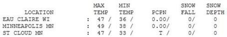
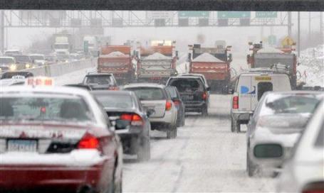
 Raw Friday.
 Yesterday was fairly unpleasant - a gray sky spitting a few sprinkles, winds gusting to 30 mph - you could feel a storm brewing. Highs ranged from 39 at Alexandria to
47 in St. Cloud, 49 in the Twin Cities.
Paul's SC Times Outlook for St. Cloud and all of central Minnesota:
TODAY: 1-23slushy snow early. PM clearing. Windy and unseasonably cool. Winds: NW 15-25. High: 44
SATURDAY NIGHT: Partly cloudy - some wet, slushy roads may become icy. Low: 28
SUNDAY: Intervals of sun, feels like spring again. Winds: NW 8-13. High: 49
MONDAY: Light rain/drizzle arrives late. Low: 35. High: 47
TUESDAY: Heavier rain possible, especially south/east of the Twin Cities. Low: 35. High: 45
WEDNESDAY: Fleeting sun returns, best day of the week? Low: 36. High: 49
THURSDAY: Light rain, drizzle returns. Low: 35. High: 48
FRIDAY: A cold rain, rapidly greening lawns. Low: 37. High: 47
Extended "Weather Trend"
Saturday (April 23): Damp start, then slow clearing, cool breeze. High: 50
Sunday (April 24): Nicer day of the weekend? Partly sunny and milder. High: 58
Groan-worthy
This is why Minnesota will never have a population of 10 million. "Accumulating snow in mid April? Where are you living?" Just as well. Consider this weather-insurance; we'll never become Chicago (with lakes).
It could be worse. Much worse. 13.6" of snow delighted residents of the Twin Cities on April 15, 1983. Almost 10" fell on April 30, 1984. Character-building indeed. Any slush in your yard should melt by afternoon as temperatures rise into the 40s; the sun may peek through later.
Up north snow may linger a few days - the Duluth area could wind up with 4-7" of snow. A little April skiing up at Lutsen?
Sunday will feel more like spring as temperatures rise above 50, but a cooler than average week is shaping up next week. The jet stream will be locked over Minnesota, meaning rapid weather changes and frequent storms. The lowest mile of the atmosphere should be warm enough for a little rain late Monday, mixed with wet snow up north. Another southern storm may spread heavier rain into town Tuesday, more rain possible next Friday.
Take a bow; if we pick up at least 2/10ths of an inch of snow today (likely), this will become the 4th snowiest winter on record. Ugh.
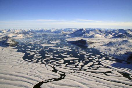
Arctic Climate Change A "Crucial Foreign Policy Issue." Here's the challenge: at the same time the Arctic is warming rapidly, ice melting faster than supercomputers were predicting a decade ago, there's a mad scramble underway to unlock some of the oil reserves under the North Pole. Who owns the oil under the Arctic? Great question. Canada, the USA and Russia are all claiming dibs on some of that oil. The
story from the Vancouver Sun: "Arctic climate change is one of the most crucial foreign and environmental policy issues facing Canada, but it has largely been ignored by all parties in the current federal election, says former foreign minister Lloyd Axworthy, president and vice-chancellor of the University of Winnipeg, speaking at a Toronto event to discuss a report on Arctic climate change released this week by U.S.-based Aspen Institute. "As Canadians once again go to the polls to choose a new Parliament, the future of the Arctic needs to be part of the election debate. So far, no one is talking about it," said Axworthy, who served on the Aspen Institute's commission on Arctic climate change. "With the implications of climate change on the Arctic ecosystem, for indigenous and northern communities or for Canada's sovereignty, the Arctic will be one of Canada's most important foreign policy priorities in the 21st century. Canadians need to know where all of their political parties stand on this critical issue."
 On Global Warming Our Best May Not Be Good Enough
. A rather sobering
article from newstimes.com: "
If every light bulb was florescent, if we stopped every coal-burning power plant in the United States, China and India, we'd still have a long way to go,'' Shellenberger said this week in Hartford, beginning a year-long lecture series that will mark the 40th anniversary of the state Department of Environmental Protection. Here's the laundry list the world would need to seriously address global warming, Shellenberger said: 30 new nuclear plants; 17,000 wind-powered generators; 400 biomass plants; two huge hydroelectric dams the size of the massive Three Rivers Gorge plant in China; and 42 natural gas plants."
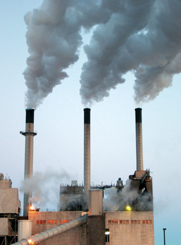
TVA Agrees to Shudder 18 Generators That Use Coal. The New York Times has the details of a sweeping decision by the Tennessee Valley Authority to move away from coal-fired plants: "
In a sweeping legal settlement, the Tennessee Valley Authority has agreed for the first time to reduce its overall capacity to generate coal-fired electricity, promising to close 18 of its coal-burning generators over the next six years while spending $3 billion to $5 billion on pollution controls on any remaining units that use coal. The accord, announced Thursday by the Environmental Protection Agency, will bring about one of the most significant cuts in coal-fired power generation by any utility that relies heavily on coal in its fuel mix. The closings will eliminate 16 percent of the authority’s coal-fired capacity, and the accord holds out the prospect that some or all of another 18 units will shut down as well, for a total loss of as much as a third of the authority’s coal-burning capacity."
*
T.V.A. Considers Upgrades For 6 Nuclear Reactors. In response to the nuclear disaster in Japan the Tennessee Valley Authority is proposing upgrades/improvements to prevent the risk of catastrophic problems resulting from earthquakes or flooding. The New York Times
reports: "
The Tennessee Valley Authority said Thursday it was considering millions of dollars of improvements to protect its six nuclear reactors from earthquakes and floods.
It is the first American reactor operator to announce safety changes that it is weighing since an earthquake and tsunami set off a nuclear crisis at the Fukushima Daiichi plant in Japan last month. Other operators have said publicly that they might have to make changes, but they have avoided saying what those were."


No comments:
Post a Comment