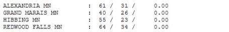
+15 F. Sunday temperatures are expected to average 10-20 degrees above normal.
65 F. predicted high later today, 15 degrees above average.
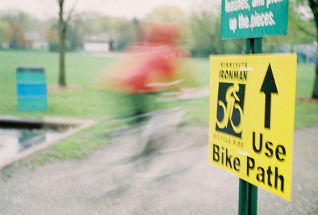
Twins Fans can expect a partly sunny sky, southeast breeze - odds favor dry weather for the Home Opener vs. the A's.
50s expected Saturday as a warm front stalls nearby, keeping us mostly cloudy and damp. If the sun comes out we should see 60s, but right now I'm pessimistic about that scenario.
Upper 60s possible Sunday. Those temperatures are typical for mid May.
80+ F. from Albert Lea to Rochester by Sunday? If the sun is out for even a couple of hours 80s are possible south/east of MSP.
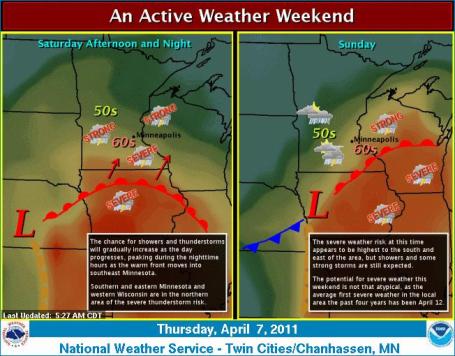
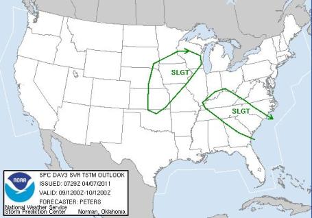
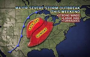
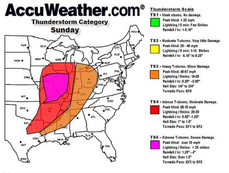
Slight Severe Risk. SPC has southeastern Minnesota in a "slight risk" of isolated severe storms. The best chance of hail and potentially damaging winds will come from late Saturday into Sunday. St. Cloud will be on the fringe of any strong/severe storms - a greater risk closer to the Twin Cities Sunday.
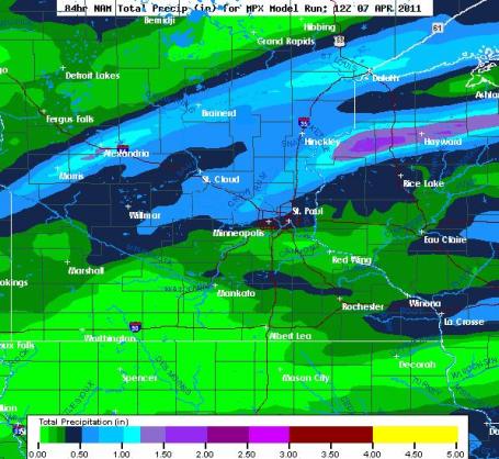
Saturday: frontal boundary may get "stuck" over central/southern Minnesota with low clouds and a cool east wind. My hunch (based on the latest NAM model) is that highs may hold in the 50s in the metro area, 60s possible south of the Minnesota River. A shower is possible, but much of the day will be dry with a little drizzle.
Sunday: warmer, wetter day of the weekend with higher humidity levels (dew points rising above 60), muggy and unsettled with more numerous showers/T-storms, a few may turn severe later in the day.
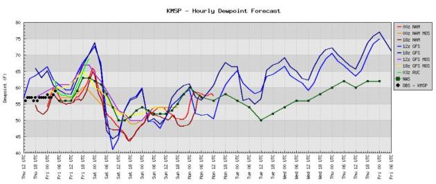
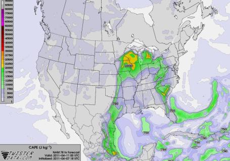
Muggy Sunday? In a little over 2 weeks we will have gone from neighbors whining about 4-8" of slush to neighbors complaining about the 'dang dew point. Models are hinting at dew points above 64 by Sunday evening at 7 pm - moisture levels you'd expect to see in June. This surge of moisture may set the stage for an outbreak of strong to severe storms, best chance PM hours on Sunday.
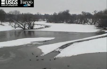
Fargo Time-Lapse. Check out the rising Red River near Fargo, courtesy of the USGS and the City of Fargo. The timeline goes up to April 7.
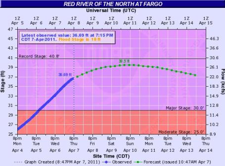
Weekend Crest. According to NOAA river forecasters the Red River in Fargo is predicted to crest sometime this weekend at 39.5 feet, a little more than a foot below the all-time record crest set in March, 2009. A close call indeed.
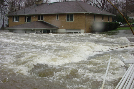
Turn Around, Don't Drown! Tacky, but memorable, right? Only extreme heat claims more lives in the USA than flooding. More important factoids from NOAA: "Did you know fast moving water just above your ankles can knock you off your feet? Most people do not! That’s why each year, more deaths occur due to flooding than from any other thunderstorm related hazard. Many of the deaths occur in automobiles as they are swept downstream. Of these drownings, many are preventable, but too many people continue to drive around the barriers that warn you the road is flooded. You will not know the depth of the water nor will you know the condition of the road under the water. Whether you are driving or walking, if you come to a flooded road, Turn Around Don't Drown!"
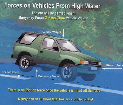
Flash Flood Details. An average of 140 Americans lose their lives to flooding every year. Only 6" of rapidly moving water can knock you off your feet, just 2 feet of water can turn your vehicle into a boat. This is where people get into trouble - they underestimate the depth of water on the highway (easy to do at night) and before they know it their vehicle is floating downstream! NOAA has more facts about flash flooding here.
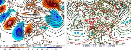
Ripe For Watches/Warnings? The European ECMWF solution predicts an intense area of low pressure near Sioux Falls, South Dakota Sunday morning, a warm front draped over southern Minnesota. South of this boundary 80s are likely over Iowa, possible far southeastern Minnesota. I still think we'll see 70s here in the metro area. The more sun (and higher the mercury rises) the greater the potential for a severe storm outbreak later in the day.
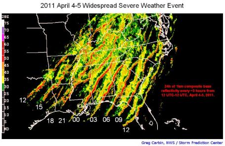
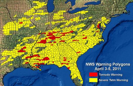
I've Never Seen This Before. An entire state covered in warnings? That was the case from Alabama to Georgia and South Carolina, and a significant percentage of every state from Arkansas and Mississippi to Virginia - a few warnings as close to us as central Wisconsin. Data courtesy of NOAA.
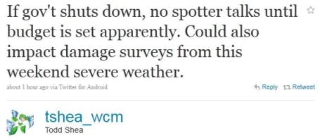
Impact On The National Weather Service? I don't pretend to know how or even if National Weather Service operations might be impacted if the federal government does in fact shut down - I've been assured that any budget impasse would not affect the issuance of day to day forecasts or warnings. Time will tell.
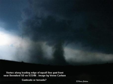
Tornado or Gustnado? Jon Davies has a look at the severe storm of April 3 near Perry, Kansas. Was it a true tornado, or a "gustnado", formed along the periphery of a powerful outflow boundary? And do you care at this point? Only the most true-blued weather geeks may be interested, but I thought I'd include this post (for educational purposes): "My analysis (previous blog post) of the setting for Sunday's "gustnado" on 4/3/11 near Perry KS stirred up different reactions and opinions as to whether Sunday's vortex actually was a "tornado" or not. Nature certainly defies categories made by man, and there are definite gray areas in classifying tornadoes and small-scale atmospheric vortices. Sunday's "gustnado" was not associated with a mesoscyclone. But a "landspout" (a non-supercell _tornado_ according to the AMS glossary) isn't associated with a mesocyclone, either, and is considered a tornado because the vortex (along a nearly stationary or slow-moving boundary) extends well up into the cloud of the parent thunderstorm, with dust typically extending in a vertical column all the way to cloud base, often under a condensation funnel aloft. Gustnadoes always occur along thunderstorm gust fronts and are more shallow; the AMS glossary definition also categorizes them as "weak" and "short-lived".
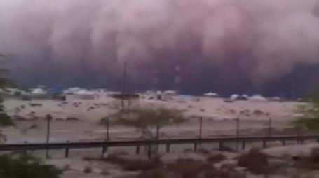
Perspective. There are a lot of things we DON'T have to worry about here in Minnesota: earthquakes, tsunamis, volcanoes, hurricanes and sandstorms. Check out this YouTube clip of a massive sandstorm that swept across the deserts of Kuwait in late March. It lasted over an hour, visibilities dropped to zero in choking dust/sand; the act of breathing became nearly impossible out in the open. The photographer who shot the video adds: "We were fine inside the car especially that we had the closed circuit A/C, no external air. Could you imagine that we picked up a guy who was walking before the storm hits, and when it did he lost his way and he could not see a thing. he was in the storm for an hour or so, he only saw the lights and flashers of our car and he ran toward us. he freaked us out when he hit the glass of the car, cuz we could not see him coming and we were driving sooooo slow."
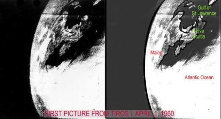
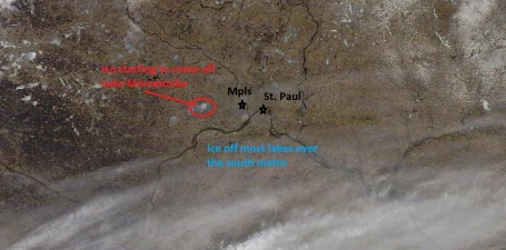
Before & After. The top photo is the first, grainy, black and white image from the world's first weather satellite, Tiros-1, launched by the National Weather Service on April 1, 1960. The bottom image is from NASA's low-orbitting "Terra" satellite with 250 meter resolution. The detail is remarkable - showing ice already off most lakes in the south metro, just starting to come off on Lake Minnetonka, roughly 2 weeks later than 2010.
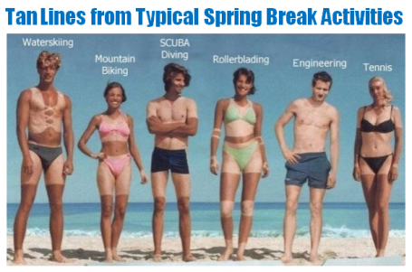
How To Recognize A Minnesotan On The Beach. What I'd give for a tan line right about now. I know - bad for the skin. But still....
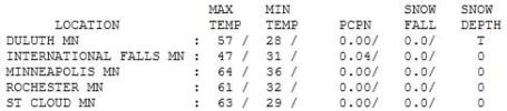
Feeling Feverish. A few weeks ago we were talking about a "chance of 60s" for the second week of April, but I didn't think it would get quite this warm - this fast. Yesterday the mercury peaked at 63 in St. Cloud and 64 in the Twin Cities.
Paul's SC Times Outlook for St. Cloud and all of central Minnesota:
TODAY: Spring Fever Alert. Partly sunny and mild (probably dry for the Twins Home Opener). Winds: SE 10. High: 65
FRIDAY NIGHT: Partly cloudy, relatively mild. Low: 49
SATURDAY: Warm front stalls nearby. Mostly cloudy and damp with a little drizzle. High: 55 (60s likely over southern Minnesota).
SATURDAY NIGHT: Growing chance of a shower, maybe a few heavy T-storms over southern MN. Low: 50
SUNDAY: May-like. Becoming warm and muggy with showers, even a few severe T-storms? High: 68
MONDAY: Windy, turning cooler with showers - tapering later in the day. Low: 48. High: 56 (falling during the day)
TUESDAY: Sunny start, increasing clouds - rain possible late Tuesday. Low: 42. High: 57
WEDNESDAY: Showers taper, patchy clouds. Low: 40. High: 55
THURSDAY: Some sun, probably dry. Low: 38. High: 57
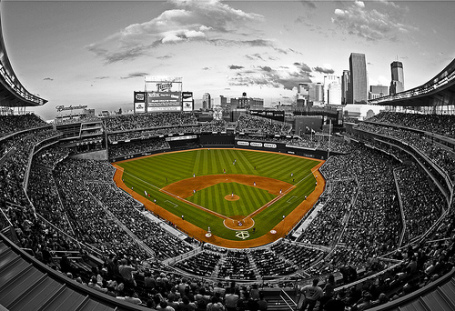
Play Ball!
Mother Nature must be a Twins fan. Considering we could be knee-deep in slush and cowering beneath heavy parkas, mid 60s (with peeks of sun) on April 8 is downright reasonable. A few ambitious fans may even show up in shorts. Who would have predicted THAT a month ago?
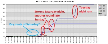
With a surge of warmth (and humidity) will come a growing thunder threat this weekend, the best chance of 70-degree warmth (and rumbles of thunder) coming Sunday. According to National Weather Service records the average date of the first "severe weather day" is April 12. Although the best chance of hail and damaging winds will probably set up south/east of the Twin Cities, a few rough storms can't be ruled out late Saturday into Sunday. A vigorous storm tracks close to MSP by Sunday, yanking a plume of moisture direct from the Gulf of Mexico. From 40s at Duluth to near 80 in Rochester, a huge temperature contrast may set the stage for T-storms; a few could pack hail and .5"+ rainfall amounts. The impact on flooding? "At this point additional rain forecast Sunday will not add to the crest, only delay the rivers/streams from falling," NWS chief Dan Luna explained.
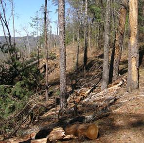
The soil is frozen & saturated; more run-off likely.
Check the blog for updates, peel off a few layers & say hello to spring!
Today's Weather Affects Attitudes On Global Warming. Maybe we're hard-wired to look out the window and make assumptions for the planet. "It's snowing - so the entire world must be cold!" Absurd? Absolutely, but you'd be amazed how many bright, otherwise logical adults are swayed by what's happening outside their windows. You've heard it before: weather is CNN, climate is the History Channel. Weather is "will I need shorts or a heavy jacket today?" Climate is the ratio of shorts to jackets in your closet. Here's an article from Live Science: "Whether people accept manmade global warming as real may depend on the weather outside that particular day, a new study finds. Social scientists have been puzzled over the disconnect between solid evidence showing that humans are causing the planet to warm and public acceptance of these findings, which seems to waver. (Poll: Are Humans Causing Global Warming?] The study results suggest that because global warming and climate are complex and long-term trends, people may be more likely to grasp onto a simpler, more easily accessible explanation — the weather. "Global warming is so complex, it appears some people are ready to be persuaded by whether their own day is warmer or cooler than usual, rather than think about whether the entire world is becoming warmer or cooler," Ye Li, a postdoctoral researcher at the Columbia Business School's Center for Decision Sciences, said in a statement. "It is striking that society has spent so much money, time and effort educating people about this issue, yet people are still so easily influenced."

Tennessee House OK's Bill Shielding Teachers Who Doubt Evolution, Global Warming. A recent article from the timesfreepress.com: "NASHVILLE — The House voted 70-23 today for a bill backers say shields teachers from being disciplined if they discuss alternatives to evolution and global warming theories with students. The debate ranged over the scientific method, “intellectual bullies,” hair spray and “Inherit the Wind,” a 1960 movie about the 1925 Scopes Trial in Dayton, Tenn. Rep. Bill Dunn, R-Knoxville, said the bill’s intent is to promote “critical thinking” in science classrooms. Critics contend it’s a shield to allow the teaching of evolution alternatives such as intelligent design and creationism. Bill supporter Rep. Richard Floyd, R-Chattanooga, said that “since the late ‘50s, early ‘60s when we let the intellectual bullies hijack our education system, we’ve been on a slippery slope.” “This is a common-sense bill,” Floyd said. “Thank you for bringing this bill to protect our teachers from the other intellectual bullies.”
Intellectual bullies? A long time ago, during a saner period of our history, we called these people "scientists".
No comments:
Post a Comment